Abstract
This Editorial lead article for the Journal of Location Based Services surveys this complex and multi-disciplinary field and identifies the key research issues. Although this field has produced early commercial disappointments, the inevitability that pervasive location-aware services on mobile devices will emerge means that much research is needed to inform these developments. The article reviews firstly: the science and technology of positioning, geographic information science, mobile cartography, spatial cognition and interfaces, information science, ubiquitous computing; and secondly the business, content and legal, social and ethics aspects, before synthesising the key issues for this new field.
1. Introduction
In this opening article of the Journal of Location Based Services (JLBS) we aim to assess the scope of a new and highly interdisciplinary field, to pull together a diverse literature and to define a research agenda. At a high level of abstraction location based services (LBS) are computer applications that deliver information depending on the location of the device and user, but beyond this generality it is hard to find a consensus on scope or definition. This is often an indication that a new technology has an extremely wide domain of applicability and impact, and the enormous interest in the concept and early implementations of LBS seem to bear this out. This then, is the moment when a scientific journal can provide a focus for the debate and an authoritative source of rigorously reviewed research contributions.
We would like to extend this invitation even to those engaged in the intense software development activity around the next generation of location-aware applications. Documenting how applications were designed and built at the appropriate point in the development cycle can help trace the design assumptions embedded in the systems, can help with future patent disputes and protects the community from losing its ‘institutional memory’ when documentation or staff are lost from key developments. Though there is an Editorial blog for this journal (http://isblogs.soi.city.ac.uk/staff/raper/), blogging and ‘white papers’ are not tested openly and rigorously the way that scientific publication is and so cannot be relied upon in the same way, especially in the long term. This is then why we are founding a scientific journal in an area experiencing very rapid change and development.
It is perhaps appropriate to begin by asking what key questions LBS raise that require research work in addition to the commercial development going on in parallel? In broad terms researchers can:
-
Envisage and embody ‘blue sky’ innovations;
-
Explore user experiences and social implications outside commercial implementation;
-
Tackle technical problems that lead to system developments without an early return.
We are also interested in publishing the implementation details of foundational technologies for LBS: we hope that some commercial players will use the Journal to publish their design, technology and business models when it is commercially feasible to do so.
The early history of LBS offers an illustration of the value of the role of research: mobile telecom operators worldwide rushed to market with a variety of LBS that did not meet with widespread user acceptance. Research undertaken in parallel with this commercial ‘gold rush’ showed that there were many potential applications in areas not explored by the mobile operators, that location privacy was a greater issue than initially appreciated (Raper Citation2001), and that users had stringent requirements of location technology that were not realised by the early implementers. The JLBS aims to identify and capture this research in a wide range of fields to enable LBS developers, researchers and observers to advance the technology and user experience.
LBS pose particular challenges to developers by virtue of the complex technological infrastructures required to support them. LBS generally require mobile devices with network access and positioning technologies, both of which typically require support infrastructures with high reliability and low latency performance on a wide range of user devices. Devices are specified either by original equipment manufacturers (OEMs) delivering at the cutting edge of technology, or by mobile telecom operators who look for device capabilities matching the profile of users in different markets. In an environment where the systems are complex and require a high level of inter-operability, it is rare for LBS software developers to be able to specify mobile devices. This means that the value chain often produces ‘devices looking for a use or user’, and there are significant challenges for service providers and software developers to design and implement LBS in this environment. The JLBS aims to provide a communication space for all the technological players in the value chain, to help in the optimisation of device specifications. Ultimately, this should improve the utility of such devices and services to the user: this is the highest objective in this field. In the end, the user simply wants to make good decisions, and wants the information that can support this. As yet we know little about mobile decision-making, and how it is different from generic decision-making. For example, what are the characteristics of a location-based decision system (Rinner and Raubal Citation2004).
Unlike many computer applications LBS are intrinsically service-oriented, meaning that streams of location-sensitive information to the user have to be supplied and maintained. LBS are sometimes delivered as stand-alone devices with inclusive information architectures, e.g. global positioning system (GPS) receivers with on-board maps; in other cases they are exclusively network-delivered with information maintained in real time, e.g. mobile phone LBS. In both cases the information needs to be delivered against a service specification. At present, such specifications are in their infancy and users have to assess the services by direct experience or by testimonials, rather than by objective analysis of metadata or quality indicators. JLBS can be a forum for the discussion of service-oriented questions, by bringing together the perspectives of data collector, ‘e-tailer’ and the user.
The implications of LBS also extend outside the technical scope of their implementation and their delivery as services. New technologies with potentially wide usage also bring significant social implications, and LBS may be an extreme example. LBS by their nature identify and process location data, which is often stored on servers either due to legislative requirements or operational necessity. This location data can be used to monitor behaviour (e.g. by tracking movement) or enhance participation (e.g. through ‘mobile voting’). The implications of this new stream of location data could be far-reaching: if this data is put under user control it could have many emancipatory effects (e.g. monitoring personal exercise regimes), but the potential for privacy abuse by states and corporations is also ever-present. The JLBS would like to publish papers that contribute to this debate.
One final question for this introductory survey of the issues: to what extent are LBS ‘special’ and deserving of this particular research focus? There are many specific reasons for this; however, one general point may suffice as a justification. In the ‘digital transition’ of the last decade almost all artefacts that people use have been re-invented in digital form. Among these artefacts, the most important are those that produce information for the most crucial forms of human knowledge. If we use Ranganathan's famous dictum (Citation1931) that all knowledge can be divided into one of five fundamental categories–personality, matter, energy, space and time–we can see that all except space have established digital artefacts in mass distribution. LBS may be the field from which a ‘space’ artefact can emerge.
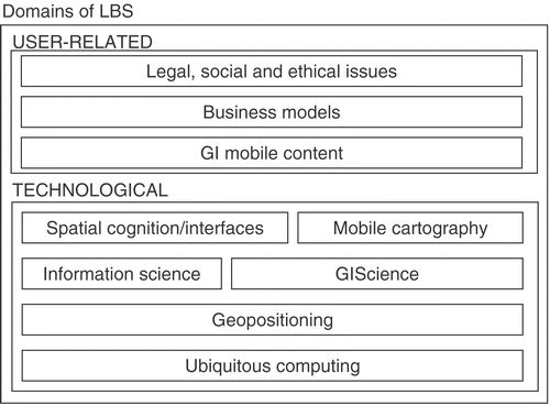
This article reviews firstly: the science and technology of positioning, geographic information science, mobile cartography, spatial cognition and interfaces, information science, ubiquitous computing; and secondly the business, content and legal, social and ethics aspects, before synthesising the key issues for this new field ().
Figure 1. The domains of LBS.
2. The scope of LBS
2.1. Science and technologies of importance to LBS
In this section, we review the science and technologies of key importance to LBS in order to derive key research issues and findings.
2.1.1. Geopositioning
Location or position determination, or ‘geopositioning’, is a crucial technology for LBS, as is the contextual mapping of the natural and built environment. Invariably any LBS application must answer canonical questions such as ‘where am I, the user’, ‘where is X, the target object, place, person’, as well as more complex questions such as ‘how do I go from A to B using a route optimised against certain criteria’? The first question requires the use of position determination technology (PDT) that is either carried by the person initiating the query, e.g. a GPS receiver, or is accessed over a network connection, e.g. as in the case of mobile phone-based positioning. The second question may be posed in several ways. In one mode this could be a question asked by a service provider, an employer, an emergency management worker, who wants to track or find an object or person for a range of reasons. This kind of query is dependent on both geopositioning and the availability of ‘point of interest’ databases. In another mode, this request may have been initiated by the object or person who needs help, or needs to receive information dependent on place. The third question answers the standard navigation query, and requires not only the positions of the two places/points ‘A’ and ‘B’, but also a knowledge of the possible routes between them and the points of interest in their neighbourhoods.
2.1.1.1. Global navigation satellite systems
Unquestionably, the US Global Positioning System has played a profound role in making PDT accessible to all (http://www.navcen.uscg.gov/). Prior to GPS, position determination for the layperson was little more than describing where they stood, or lived, or worked, or the road they were travelling on, depending on the context. It is impossible to understand the growth in LBS, or even ‘infomobility’ in a wider context, without acknowledging the crucial role of GPS. GPS technology can be used anywhere in the world, operates 24/7, costs nothing to use, uses comparatively cheap hardware with a small form factor, and, surprisingly, is now quite a mature technology. Since it was declared fully operational in mid-1990s, GPS has revolutionised navigation, as well as the high accuracy engineering construction, mapping, surveying and geoscience fields. In fact, although GPS is currently the only fully operational global navigation satellite system (GNSS), its very success has spawned imitators such as Russia's GLONASS (to reach full deployment by the end of this decade) (http://www.glonass-ianc.rsa.ru/) and the EU's planned GALILEO (expected to be fully operational in 5–6 years) (http://www.esa.int/esaNA/galileo.html). GPS itself is also undergoing a ‘modernisation’ process that will make it even more useful than it currently is (http://www.navcen.uscg.gov/gps/modernisation/default.htm).
GPS is currently the ‘first choice’ PDT for almost all consumer, professional and scientific applications of geopositioning. Why is there a need to improve it? The reason is simple, its greatest shortcoming is that it doesn’t work well (more precisely, the satellite signals are too weak to track) in urban environments amongst buildings and trees, and is even less available indoors. Availability of a geopositioning capability is a vital performance parameter for LBS, perhaps even more so than positioning accuracy. Approximately 50% of the world's population now lives in urbanised areas, hence GPS's (and to a significant extent, also other GNSSs’) low availability in such environments is a significant blow to the GPS user technology industry. On the other hand, this shortcoming has spurred considerable research since the mid-1990s (Rizos Citation2005). How to increase the sensitivity of GPS receivers to track weak signals inside buildings? How to discriminate among multiple reflected signals (or multipath)? How to increase the speed of positioning using aiding information provided by the mobile phone airlink (assisted-GPS, or A-GPS)? How to improve the design of next generation satellite signals to make urban GNSS more reliable? These questions are part of the research agenda for GPS (and GNSS) designers that address the urban/indoor positioning challenge. It could be argued that the development of ‘assisted GPS’ and high sensitivity receiver technologies over the last decade have been the most significant innovations in GPS user equipment since the differential GPS and carrier-phase-based GPS positioning techniques emerged in the 1980s (Bryant Citation2004). One of the most important assisted GPS platforms is the BREW development environment for the Qualcomm gpsOne chip which is used in CDMA2000 third generation networks in a number of countries, notably Japan, China and the US.
It must be emphasised that the enormous interest in GPS for consumer applications such as LBS was something never envisaged by its designers. A future where every individual, vehicle and significant asset will have a ‘ubiquitous positioning’ capability is only possible if GNSS is universally adopted, as the developers of the EU's GALILEO programme hope. This remains to be seen that the case for GNSS to support infrastructures like road pricing is still not fully accepted given the possibility of multipath errors, as Germany's GNSS-based lorry traffic pricing has shown. More research needs to be done on the cost/benefits of different positioning infrastructures for key applications.
Recognition that GNSS, and regional navigation satellite systems (RNSSs), have a myriad of civilian and military functions (they are often described as ‘dual-use’ technologies) has also elicited announcements from
-
China that it would develop its own GNSS known as COMPASS (or BEIDOU)
-
India that it would develop its own Indian RNSS, and
-
Japan that it is undertaking R&D into RNSS
Given the existence of these different systems, the challenge is going to be to ensure that as many of these signals are as ‘inter-operable’ as possible, meaning that a low-cost multi-GNSS receiver can be built that uses:
-
signals from independent GNSS to increase accuracy, availability and integrity
-
any available compatible GNSSs/RNSSs (i.e. satellite signals from one system do not jam other satellite signals, or deny or interfere with services based on such signals.
-
common geodetic standards
The future of GNSS/RNSS is more satellites broadcasting many more signals and frequencies than the current GPS. But can signal availability really be so markedly improved that urban and indoor geopositioning, at all times, will be possible? These are key questions on which the future of LBS will also depend.
2.1.1.2. Terrestrial wave-based positioning systems
Despite improvements in GNSS user equipment, many researchers and technologists believe that poor urban/indoor positioning is in fact the ‘Achilles Heel’ of GNSS, and that the challenge of ubiquitous geopositioning can never be satisfactorily addressed using GNSS alone. The search for other PDTs with all of the advantages of GPS (low cost, global reach, high accuracy), but with increased urban availability, has been well and truly on for many years (Mountain and Raper Citation2000a). Unfortunately, there does not appear to be a clear winner. Some alternative PDTs use signals not designed for positioning, such as those intended for wireless communications or broadcasting. These include mobile phone signals themselves (Chen et al. Citation2006), radio or TV signals (Krumm et al. Citation2003, Youssef et al. Citation2005a) and a host of short-range communications signals such as WiFi (Bellavista et al. Citation2004, Krumm and Horvitz Citation2004), Bluetooth (Madhavapeddy and Tse Citation2005), Zigbee, UWB (Cadman Citation2003), RFID (McCarthy and Curran Citation2007) and so on. There are a range of mathematical techniques that can be applied based on the measurement type. These include TOA, TDOA, AOA, cell-ID/beacon/proximity, as well as combinations of these (McGuire et al. Citation2005).
Research into determining position from mobile phone signals and measurements has a long history, but received a particular boost as a result of the E-911 mandate in the US (http://www.fcc.gov/911/enhanced/). Nevertheless, to date, the mobile operators have been extremely unwilling to implement any but the most rudimentary, lowest accuracy techniques (based on cell-ID) as they have been reluctant to make the necessary investments. There is still considerable scepticism in mobile operators that LBS is ready for mainstream mobile phone users. Therefore, mobile operators in many parts of the world are increasingly pressuring the handset manufacturers to incorporate PDT technology that does not require an upgrade or augmentation of the terrestrial mobile phone network. In such circumstances it is not surprising that they are adopting A-GPS/GNSS technologies in preference to those based on the mobile phone signals themselves. Nevertheless, it is unlikely that A-GPS/GNSS will be the only PDT embedded within mobile phones, as there is the need to address the positioning requirements of legacy handsets–there are only a few countries (such as Japan) where the vast majority of mobile phone handsets are being delivered with inbuilt GPS (De La Fuente et al. Citation2005).
But it is unlikely that GNSS technology will be used for most future applications. GNSS receivers are complex, draw significant power, and do not work well in urban/indoor environments. The future would therefore appear bright for well-designed PDTs based on wireless communications ‘signals of opportunity’. What makes these attractive options is that many of them are (or will be) built into personal devices that people carry, fitted into vehicles, or attached to objects. Hence in such scenarios geopositioning can be considered a by-product of the ‘wired world’. WiFi and RFID are two technologies that have particularly good prospects. The former because of the increasing ubiquity of WiFi access points in urban areas to support wireless Internet connectivity. The latter because of the revolution currently underway in the logistics, asset tracking and inventory industries. However, in reality, the level of performance (as measured in terms of availability, accuracy, repeatability) is often disappointing and their adoption may be (at least initially) restricted to niche applications. For example, they could play a role in the delivery of certain types of LBS, e.g. ‘hot zone’ deployments in convention centres, shopping malls, museums or densely populated CBD areas.
There has also been considerable research into the development of local-area positioning systems based on specially designed signals, transmitters and receivers (Kolodziej and Hjelm Citation2006). These PDTs tend to have higher performance, but are more expensive than those based on communications signals – as they cannot take advantage of the economies of scale in the development and manufacture of personal communications devices. It is therefore likely that most of these will be deployed only in areas where geopositioning must satisfy stringent accuracy and availability requirements, such as in factories, warehouses, etc. What they share with PDTs based on communications signals is the need for terrestrial ‘infrastructure’ of signal transmitters or transceivers. GNSS infrastructure is essentially the constellation of orbiting satellites themselves (the cost of deployment being largely met by taxpayers of the US, Russia or the EU). Who will underwrite the deployment of terrestrial infrastructure? Will there be a primary (well-cashed) user base that is prepared to sink the initial investment? What business models, in terms of revenue generation to provide a return-on-investment, are feasible? However, easily accessible – in a ‘global roaming’ sense–mobile phone or WiFi-based geopositioning is many years away, primarily due to differences in standards in hardware, service architecture, business models, and so on, across countries and regions. Hence, local positioning systems are likely to be implemented on an ad hoc basis–here and there as the need arises–without concern for inter-operability of PDTs across large geographical areas or user communities.
2.1.1.3. Non-signal based PDTs
What about PDTs that do not need any installed infrastructure? In this class of technologies are the inertial sensors (accelerometers, gyroscopes), digital compasses, barometers and pedometers. Many of these are undergoing rapid improvements in accuracy, lowering of manufacturing costs and increased miniaturisation. There are two basic directions of research. One is focused on Micro-Electro-Mechanical Systems (MEMS), sensors or devices fabricated by techniques used in microelectronics, that integrate mechanical and electrical functions (Niu et al. Citation2006). These include accelerometers and gyroscopes, which can be integrated with GPS (Scott-Young and Kealy Citation2002). Research into the use of digital compasses to provide orientation while the user is stationary is still small-scale (Simon et al. Citation2005), though this area may have to grow significantly if orientation is shown to be a ‘must-have’ consumer need for LBS. The quality of MEMS sensors is rapidly improving due to significant R&D being invested to address the strong demand for such sensors in a wide range of consumer devices (mobile phones, video cameras, MP3 players and so on) and vehicles (ABS, stability control, etc). In the research direction, basic research is being undertaken to develop novel inertial sensors of incredibly high fidelity based on some esoteric properties of Quantum Mechanics. While MEMS research is undertaken by both commercial firms and the military, the more ‘blue sky’ navigation sensor research is being conducted or underwritten by the military–in fact the development of GPS itself was originally driven by the needs of the US military. By the end of the next decade, ‘dead reckoning’ relative position determination technologies may challenge GNSS (and other RF-based PDT) for urban/indoor applications.
Included in this category are a range of techniques that give position information as a by-product of other operations. One important group of techniques are based on surveillance technologies such as CCTV and similar scanner and imaging systems. These are fixed in location and when a person or object comes within range, its position is defined as being the location of the fixed CCTV or imaging system. This is identical in concept to cell-ID, in that a mobile phone's location is determined to be that of the centre of the ‘cell’ (the mobile tower). Research is also being undertaken into the automated recognition scenes from image databases (Xu et al. Citation2003, Mai et al. Citation2004). Another method is ‘map matching’ where positioning information derived from a navigation sensor is then augmented by map data that constrains a vehicle's position to the road network as defined by road centreline data contained within a GIS. This is a key technique for in-car navigation (‘satnav’) systems.
2.1.1.4. The ‘universal positioning’ device
Current research into a broad range of PDTs is a healthy trend. But is this interest in geopositioning merely reflecting the unmet demand of LBS developers and implementers for a ‘universal’ PDT? Yes and no. PDT R&D is largely driven by military, professional navigation and scientific applications. Development of GNSS in particular is increasingly part of national political agendas. The US wants to preserve its leadership in satellite-based positioning, navigation and timing technologies such as GPS, both to support its high-tech industries as well as to ensure that its military has complete control over its own PDTs (and is able to deny them to its adversaries). Given the well publicised vulnerability of GPS (and GNSSs in general) to RF interference as signalled by the US Department of Transportation Volpe Report (2001), back-up systems such as are afforded by combinations of inertial sensors are increasingly being incorporated into smart weapons and warfighting platforms (ships, aircraft, vehicles) that previously were only fitted with GPS receivers. On the other hand, the development of local-area positioning systems based on a variety of wireless communications technologies, or using dedicated RF-based systems, is generally being driven by business-to-business applications such as health/hospital, manufacturing, asset tracking, logistics, machine automation/robotics, and office innovations. However, LBS will ultimately be the beneficiary of advances in PDT R&D.
While the hunt for the ‘universal’ PDT continues, most investigators will concede that some sort of integrated or hybrid geopositioning system is likely to be the interim solution. It will consist of several position (or relative position) sensor technologies, invariably with GPS/GNSS at its heart, with a data fusion algorithm blending the data from each individual sensor so as to provide the best possible estimate position (Fox et al. Citation2003, Kargl and Bernauer Citation2005). Hence a fertile area of research is ‘multi-sensor integration’, not merely in the mathematical sense of a Kalman filter, but also the definition of appropriate frameworks of primary and secondary PDTs in which graceful degradation of geopositioning output is possible as one or more sensor data is unavailable or unacceptably degraded in quality. The Location Stack was proposed (Hightower et al. Citation2002) and implemented (Graumann et al. Citation2003) modelled on seven-layer OSI networking model to promote positional fusion at the following levels, from bottom up:
-
Sensors, exporting raw data values
-
Measurements, raw sensor data plus the uncertainty intrinsic to the sensing technology
-
Fusion, of measurements, definition of geodetic frame
-
Arrangements, reasoning about location information produced
-
Contextual fusion, merging location and non-location data, e.g. sensor states
-
Activities, relating location to semantic states
-
Intentions, cognitive desires of users
What is certain is that despite the significant advantages of satellite-based PDTs such as GNSS, it will not be the only geopositioning technology that will benefit from the considerable R&D being invested in ‘ubiquitous positioning’.
2.1.2. GIScience
Once positioned, LBS applications need to manage the streams of spatial data, represent the data acquired, provide compelling applications for navigation, search and information, and model the geography of the environment around the user. Each of these objectives poses exceptional challenges given the characteristics of the mobility experience and the typical user profile.
2.1.2.1. Mobile spatial data management
The first of these challenges is mobile spatial data management, both managing the incoming positional streams (and integrating them as required), and marshalling the various data sources to which the user may need access. The solutions to these challenges depend on the implementation environment, whether transaction-oriented mobile operator databases, experimental spatio-temporal databases or client-server environments.
Relatively little has been published on mobile operator databases holding user movements due to their commercially sensitive nature, however, Varshney (Citation2003) reviewed the major location management schemes in use on mobile operator networks. Location management aims to maintain details of user location while minimising bandwidth usage and network-wide searches. Location management schemes keep track of mobile terminals (MTs) within location areas (LAs) by monitoring when the MT moves to another LA, thereby generating a location update. Most location updating uses a dynamically generated LA (composed of multiple service area cells) based on the mobility properties of the MT (either a standard distance or time threshold, or an individually generated metric). Lam et al. (Citation2005) showed that by using their Handoff-velocity prediction (HVP) scheme to assess which LA may contain the MT, they can outperform existing distance and direction-based algorithms, e.g. those suggested by Koukoutsidis and Theologou (Citation2004). Choi and Tekinay (Citation2003) noted that another key parameter in location update is maintaining the quality of service under different operating conditions.
Prakash and Baldoni (Citation2004) highlighted network timing infrastructure as a crucial issue for certain mobile applications where the order and location of events need to be preserved for decision-making. With the exception of CDMA 2000 networks, most mobile networks do not transmit precise timing, and hence applications requiring synchronisation, such as mobile gaming or mobile event payment, need an alternative source of timing, such as a GPS receiver time. This issue is bound to become progressively more important as mobile devices are used more and more for real-time interactions with services.
A wide range of work has been done on spatio-temporal databases (Abraham and Roddick Citation1999) and, more recently, moving point storage within them (Mouza and Rigaux Citation2005). Accordingly, a number of studies have examined how spatio-temporal databases can handle streams of location data from mobile devices. Blunck et al. (Citation2006) abstracted the problem by suggesting that the stream of positional data should be converted to a kinetic data structure for efficiency, and so a class of algorithms can be developed to handle it, e.g. to provide constraints or services such as collision detection. Kim et al. (Citation2006) outlined the design of TMOM, a system for indexing moving points using the spatial data model of the OpenGIS ‘Simple Features Specification for SQL’, thereby making data handling more efficient. Myllymaki and Kaufman (Citation2003) proposed a classification of moving point queries for LBS including proximity queries (range queries), k-nearest neighbour queries and sorted-distance queries, and they develop performance metrics for them.
Optimising mobile spatial data management for location queries is also a major focus of research in LBS. Gratsias et al. (Citation2005) taxonomised LBS queries by the status of the user (static/moving) and the object to be found (static/moving) in order to define classes of query, i.e. static–static, mobile–static (and vice versa) and mobile–mobile, and to identify representative algorithms. This is a promising approach, but it needs to be extended by adding the dimensionality of the spatial representation of user and object so that the intersections can be computed more fully. Wu et al. (Citation2005) suggested that incremental range queries can be continually re-evaluated to locate user devices and drive pre-computed searches, while Ding et al. (Citation2006) developed a location-sensitive pre-fetching algorithm that uses a moving footprint around the user to optimise the response to queries. It remains an open question whether such architectures and algorithms will be adopted by mobile operators, who have both legacy systems and scalability issues to address.
Much of the research on mobile spatial data management has focused on mobile operator databases or experimental spatio-temporal databases that aim to use and optimise transaction-oriented DBMS accessible over a network. By contrast, some researchers have explored stateless web-based client-server models, as they are less vulnerable to network unavailability and permit ‘instant-on, instant off’ operation of clients (Kim et al. Citation2005b). Tsou (Citation2004) conducted an early mobile spatial data experiment using a WiFi-equipped laptop in a car running ArcIMS to serve spatial data to mobile Personal Digital Assistant (PDA) clients. Dias et al. (Citation2004) outline the fully web-based architecture of the WebPark system operating in several European National Parks based on the use of a mini-webserver on the client device that communicates using http protocols, and which is extended for vector data using a Scalable Vector Graphics (SVG) plugin. Follin (Citation2005) outlined how a client-server approach to mobile data management can be optimised using a multi-resolution database to transmit increments to the client when needed for a scale change. Doyle et al. (Citation2005) developed personalised maps for mobile users using web technologies to avoid the user interface complexity of a proprietary interface. Kjeldskov and Paay (Citation2006) developed a location-based web site for a public city square in Melbourne, Australia providing its users with information about surrounding places, people and activities delivered through a mobile web browser over the http protocol.
A limited amount of research on semantic web-based LBS has been proposed in which all the content and applications would be referenced to a set of ontologies. Yu et al. (Citation2003) made one of the earliest specific proposals to develop a hierarchy of spatio-temporal ontologies with a mediator to integrate them; however, this proposal was not implemented. Tryfona and Pfoser (Citation2005) presented a more formal model of domain (space, time), content and application ontologies and its implementation in the Protege open source ontology tool. Tryfona and Pfoser (Citation2005) suggested that the domain ontology for LBS should include envelopes for geographic relevance and time horizons for movement so that content could be selected in relation to these concepts, and they report that this methodology will be used for the IXNHΛATHΣ Athens Traffic Management project. Kim et al. (Citation2005a) proposed an architecture for a semantic LBS based on the OMA Open Location Services Geomobility Server, with RDF metadata and Jena API to handle the semantic expression of location-based information. This is an innovative approach; however, the semantics of the location-based information were not developed beyond typical LBS concepts of a POI: the real potential of the semantic approach is to encode intelligence in the data so both human and machine can ‘understand’ the content. This seems to be a natural way forward for LBS and will be an important research topic for the future.
2.1.2.2. Tracking
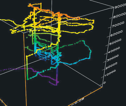
Mobile spatial data management seen from the user's point of view is ‘tracking’, and a growing number of studies have begun to focus on this topic in light of LBS. Tracking moves beyond data management into representation and interpretation of the tracks (or ‘traces’, or ‘trajectories’) in order to make a service more efficient or to make inferences about the behaviour of the user of the mobile device (Mountain and Raper Citation2000b) ().
Figure 2. Three-dimensional representation of a one-month self-tracking experiment by the lead author, showing patterns of repeated behaviour at the same time every day (x, y are geographic coordinates, z is seconds per day).
On mobile operator networks, user tracking is a necessity for managing call routing and delivery, and a number of algorithms have been developed to represent and analyse tracks (in the form of cell transition graphs). A key tracking representation in location management is the call-to-mobility rate (CMR), which can be computed by dividing the number of calls per second (usually a small fraction) by the time taken to cross an average cell in the neighbourhood. Location management algorithms must be able to perform well under a wide range of CMRs (Lam et al. Citation2005). Bhattacharya and Das (Citation1999) used an information-theoretic approach to characterise the entropy of the user's track and thus model their mobility. Samaan and Karmouch (Citation2005) applied Dempster–Shafer evidential reasoning to the challenge of predicting future locations from previous user behaviour.
Non-operational analysis of user tracks focuses on efficient characterisation and recognition of user movement patterns. Casares Giner et al. (Citation2002) found that stochastic activity networks (Petri nets) outperform Markov models in the characterisation of logged tracks. Yanagisawa et al. (Citation2003) aimed to characterise the shape of the track so that activities may be identified from them, e.g. traffic jams, and so that similarities between tracks can be detected by combining a spatial indexing technique (R+-Tree) and a dimension reduction technique called piecewise approximate aggregate (PAA). By contrast Mouza and Rigaux (Citation2005) conceptualised track analysis as a set of moves through a set of discrete zones at regular time intervals, which could be captured by a parameterised sequence of moves. Sohn et al. (Citation2006) used tracking data to carry out coarse-grained user mobility assessments, and were able to achieve reasonable comparability with pedometers in the calculation of daily step counts from mobile tracking data.
Studies of tracking have been carried out for decades: the first international conference on travel behaviour was held in 1973 (http://www.iatbr.org/). However, until the era of LBS and lightweight handheld GPS (from the mid-1990s) travel diaries were used to collect tracking information, with all the limitations that post-hoc self-recording implies. LBS and handheld GPS have allowed streams of automatically collected data to be brought together for large numbers of individuals and journeys, which could then be analysed (Kwan Citation2004). In one classic example of this methodology Wolf et al. (Citation2004) developed methods for the automated analysis of over 240, 000 tracks collected by GPS units in cars in Sweden. The most difficult problem identified was the partitioning of the stream of location data, e.g. recognising start and end points of journeys, which required the use of buffered searches to find candidate points of interest. Others such as Krumm and Horvitz (Citation2006) have made simplifying assumptions to solve this problem: in this case that an absence of movement of 5 minutes divides one journey from another. Liu et al. (Citation2006) in their methodology (1) looked for ‘stays’ (cessations of movement) in the tracking data, assisted by additional information in diaries, web pages visited by the user, and transactions, (2) searched for candidate points of interest, and then (3) checked with the user for confirmation. Koile et al. (Citation2003) defined activity zones from patterns of location and motion in tracks.
The key objectives of tracking analysis are the inference of past travel behaviour and the prediction of real-time destinations. Past travel behaviour recorded in tracking data can be analysed in several ways: Ashbrook and Starner (Citation2003) looked for clusters of points in GPS tracking data in order to characterise ‘places’ and to make Markov chain models of connected places for each user. In this model destination prediction is a function of the transition likelihood between places in each user's tracking history. Krumm and Horvitz (Citation2006) developed a methodology to predict destinations for car journeys by deriving Bayesian destination probabilities for a raster model of the study area (minus uninhabited areas) from a training data set of journeys undertaken by 169 subjects over a two-week data collection period. They distinguish between a ‘closed world’ experiment where probabilities were only assigned to previously visited destinations, and an ‘open world’ experiment where probabilities are assigned to unvisited locations by buffering visited locations, adding in a background value for all other ‘visitable’ (inhabitable) location, and an ‘efficient driving’ assumption. This approach is useful for filtering points of interest and verifying that a driver is still heading to a specified destination. However, this approach requires access to empirical data on prior mobility.
2.1.2.3. Wayfinding on mobile devices
Wayfinding studies have a long history of research dating back 50 years as researchers have explored the cognitive, linguistic and geographic aspects of a very complex problem. Progress has been made in understanding the influence of frames of reference, scale, landmarks, routes, orientation and cognitive maps (Golledge Citation1999); however, wayfinding is still recognised as a ‘hard problem’. Before (say) 2000 much of this research was conducted by designing experiments on the perception and spatial behaviour of subjects in controlled environments using paper maps as no digital device was capable of rendering the environment or giving directions. Within the last half decade there has been an explosion of new GPS-based mobile devices, ‘satnav’ for drivers and LBS for pedestrians that have begun to deliver ‘you are here’ maps, directions and contextual points of interest. Many (most?) of these satnav services have been developed commercially by major hardware manufacturers to meet a rapidly growing market without substantial scientific input from researchers. Though they have been successful in the market, many users have had concerns about the interface and content (see user forums on satnav supplier websites, and letters pages in specialist magazines).
The most researched aspects of wayfinding on mobile devices are the directions given by in-car navigation systems (‘satnav’). May et al. (Citation2003) argued that the design of such systems should begin with the driver's information needs, rather than the provision of a moving map display with spoken turn-by-turn directions. There is much dissatisfaction with the adequacy of the directions, which are based on distances to turns rather than landmarks (Sefelin et al. Citation2005). Patel et al. (Citation2006) argued that poorly designed instructions guiding the user along a poorly chosen route is adding to the cognitive load of the driver rather than reducing it, and they developed a prototype ‘personalised route’ system called MyRoute that re-routes users along familiar routes. Burnett et al. (Citation2004) argued that the use of mobile device wayfinding while driving can lead to increased visual, manual and cognitive demands on the driver, and suggest that novel user interfaces are needed to avoid the imposition of ‘reactionary legislation’ to ban their use.
One of the wider concerns about mobile device wayfinding is that the routine use of such tools may inhibit the development of a cognitive map of the environments through which people pass. Burnett and Lee (Citation2005) contrasted the traditional map user (initial task demands high, but drops with experience in the area to a point of independence from the map), with the ‘satnav’ user (low task demands but ongoing dependence on the system). They show how the satnav user has less time to look at the map, pays less attention to the environment and spends less time on navigational decision-making. This is confirmed by the personal experience of the first author, who finds that such systems can only be truly useful when used as ‘operational confirmation’ of the traditionally gathered ‘landmark’ and ‘route’ knowledge. Hence, note that Krüger et al. (Citation2004) found that users tested with a pedestrian navigation LBS built up route knowledge well, but never survey knowledge.
There is also considerable research to suggest that mobile device wayfinding would be more effective if the systems incorporated landmarks in the direction-giving. Hence, May and Ross (Citation2006) assessed the performance of both older and younger drivers tested on the road with landmark-based directions or distance-based directions, finding that for both older and younger drivers good landmark-based directions reduced driving and navigation errors and reduced the time taken looking at the display. Given the clear need for landmarks the practical problem is how to choose good ones that work for a wide audience of drivers. Burnett et al. (Citation2001) and May and Ross (Citation2006) suggested that ‘street furniture’ landmarks (such as traffic signals, crossings and service stations) were the most salient for drivers. Sefelin et al. (Citation2005) suggested several ways to find the best driving landmarks: picture recognition, analysis of route commentaries, eye-movement detection and simulated walkthroughs. Elias and Brenner (Citation2005) focused on the map data mining process needed to extract landmarks and surface modelling methods useful for landmark visibility assessment. Raubal and Winter (Citation2002) developed a method for automatically extracting personalized landmarks and integrating these with wayfinding instructions (Nothegger et al. Citation2004). This approach also takes spatio-temporal context (e.g. day versus night) into account, which leads to different selections of salient features (Winter et al. Citation2005).
As mobile devices have become more powerful and lightweight it has become possible to deliver wayfinding support to pedestrians. De la Fuente et al. (Citation2005) outlined the history and operation of the EZ Naviwalk pedestrian navigation system on the KDDI UMTS network in Japan, which was the world's first mobile wayfinding system (released in October 2003). The system (developed by Navitime) uses A-GPS positioning via the UMTS network and gives voice directions on turns and distances as a low-cost service. Ross et al. (Citation2004) showed that the experience of adding landmarks to pedestrian wayfinding applications parallels the ‘satnav’ experience in making the system more effective. Tscheligi and Sefelin (Citation2006) suggested that these systems are in their infancy (cf. satnav) and that to improve them, the critical research agenda is to:
-
integrate landmarks
-
develop work ‘in context’
-
provide compelling content.
There are also open questions about the most effective representations for pedestrian wayfinding: whether 2D or 3D (Wood et al. Citation2005), whether augmented reality or virtual reality (Liarokapis et al. Citation2006).
2.1.2.4. Space–time models for LBS
LBS pose some spatio-temporal representation and modelling problems that need novel solutions for the situated, real-time LBS environment. The challenge of delivering truly location-sensitive applications relies at a conceptual level on the characteristics of the space–time embedding used and the partitioning of space. These issues have been explored on a number of levels.
Schlieder et al. (Citation2001) posed the problem in a very abstract form: what sort of partonomy is needed to model intentional mobile behaviour, concluding that user motion is the sine qua non for locational models. Malek and Frank (Citation2006) proposed a spatio-temporal partonomy for the solution of general mobile computing problems. Hsieh et al. (Citation2004) preferred to focus on the duality of geometric and symbolic representation for mobile applications, arguing that simultaneous processing of both are needed to model mobile behaviour and querying.
Brimicombe and Li (Citation2006) focused on the modelling of a space–time envelope extending forward from the user in their direction of travel. They suggested that such envelopes can provide ‘event brokerage’, soft clipping for pre-fetching and triggering for alerts. The envelopes contain three parts (core, extension and limit): examples of envelopes calculated post-hoc for a GPS track are shown. Chon et al. (Citation2003) calculated time-dependent shortest paths for moving objects.
In the design of LBS implementations, generalisation becomes an issue when presenting information on a small screen. Sarjakoski and Sarjakoski (Citation2004) outlined the approach to generalisation taken by the GIMODIG project in which National Mapping Agencies experimented with the re-purposing of their topographic map content for mobile devices. The GIMODIG application for a PDA is based on the web feature server specification of Open Geospatial Consortium (OGC) with SVG presentation, and implements a range of generalisation operators including feature selection by class, area/line selection, contour selection by interval, line smoothing and building outline simplification. By contrast, the WebPark project (Edwardes et al. Citation2003, Burghardt et al. Citation2005) focused on the generalisation of natural species data for use by the public on rented mobile devices. Both model generalisation (e.g. filtering) and view generalisation (e.g. aggregation) are implemented in a web feature server environment so that the html pages present readable, useful output to the user.
The Time Geography of Hägerstrand (Citation1970) also provides useful heuristics for the space–time representation needed by LBS. Raubal et al. (Citation2004) proposed a theory of LBS which links time geography with a theory of affordances to model the actions that are possible for a user from any given place and any given time. This approach allows the spatial (using positioning and geo-coding), temporal (using time geographic constraints), social (using affordances) and cognitive (using decision making theory) aspects of a LBS to be modelled. This framework also implicitly challenges LBS thinking that is overly focused on space and geometric representations; however, this model has not been implemented as a LBS platform. Winter and Raubal (Citation2006) also utilised time geographic theory to model ad hoc shared trip planning where individuals are looking for rides and vehicles are looking for passengers (e.g. in an on-demand bus service). Time geography can allow individuals to determine the vehicles local to them (in time or space) and vehicles can locate individuals who want to go to their current destination. An implementation of this approach using a real street network can be found in Raubal et al. (Citation2007).
2.1.2.5. Place and location concepts for LBS
Most, if not all implemented, LBS are essentially mobile GIS applications with no semantic understanding of places, unless it is explicitly encoded in the application logic or content (Raubal et al. Citation2004). This is a big challenge for the research community as it is apparent from user testing with LBS that place knowledge is a core requirement for many users. Hightower et al. (Citation2005) approached the problem by real-time data mining the GSM cells and WiFi networks detected by a mobile device to document the user's mobility, and so the user can recognise them when they return. This approach leaves it to the user to assign names and semantics to the ‘places’ found in this way, and improves its recognition performance from 63% (one previous visit or visits lasting <10 minutes), to 80% (for places visited twice) and 90% overall. Nurmi and Koolwaaij (Citation2006) took a similar approach with their ContextWatcher application that sends a GPS position to a server every time a cell transition takes place. They review four algorithms for recognising places from this data: graph clustering, spectral clustering, duration-based grid clustering and frequent transitions. Each algorithm recognises different ‘places’, not all of which the user considers significant. Liu et al. (Citation2006) presented an algorithm for extracting ‘places’ from tracking data.
Lehikoinen and Kaikkonen (Citation2006) developed a mobile presence system and then studied the way that users employed location information. Users created on average 20 significant locations to share with their friends, which were then classified into generic locations, points of interest and geographical areas. Location was considered the most significant mobile presence attribute as it was thought to signify the status and activities of the other users.
2.1.3. Mobile cartography
Imparting spatial information in a mobile context usually involves cartographic forms of presentation; where they do involve mapping they can be called ‘map-based LBS’. The term TeleCartography can be used to refer to the distribution of cartographic forms of presentation via wireless data transfer interfaces to mobile devices (Gartner Citation2000). This field can, in turn, be subsumed under the broader methodology of Ubiquitous Cartography, as proposed by Morita (Citation2007), which defines the ability for users to create and use maps in any place and at any time to resolve geospatial problems. All of these map-based processes are linked to the foundational Cartographic Model: presentation model of geospatial data, derived from a geo-data model by means of cartographic generalisation and symbolisation.
In modern cartography, the main focus is on understanding the processes and methods for ‘communicating spatial information efficiently’. In this research, the scope of cartography goes beyond the creation of cartographic presentation forms, and has become rather focused on understanding the relations within the ‘whole system’ of spatial information communication, including the user, the models and the transmission processes. The engagement of modern cartography in fields like LBS and TeleCartography, and the various multidisciplinary approaches including cartography have to be seen in this context (Dillemuth Citation2005).
Mobile telecommunication infrastructure, geopositioning methods, mobile input/output devices and multimedia cartographic information systems are pre-requisites for developing applications that incorporate the user's position as an input to an information system. As cartographic forms of presentation are crucial to the use of LBS the resulting system can be termed as a map-based location based service.
2.1.3.1. Elements of a map-based LBS
The types of applications within LBS are extremely heterogeneous, and range from simple text-based applications using cell-ID positioning (based on unique identification of the cell of a wireless telecommunication network) for rough positioning (e.g. ‘which petrol stations are there around me?’), to map-based multimedia applications that include routing functionality (e.g. show me a 3D view of the next intersection on my route). Many different names have been applied to this range of systems. In a cartographic context the most inclusive term for these applications is the term TeleCartography, to be understood as the range of issues involved in the distribution of cartographic presentation forms via wireless data transfer interfaces and display on mobile devices.
2.1.3.2. Modelling and visualisation
Unlike on a personal computer the scope of geovisualisation is heavily influenced by the properties of the mobile device in use. However, to provide effective geovisualisation the basic conditions of the cartographic communication process have to be fulfilled when using map-based LBS. The cartographic model is highly scale-dependent and has to present appropriate task-dependent geometric and semantic information. This fact, in combination with the limitations in the size and format of current mobile devices, produces a range of different solutions for presenting information within map-based LBS:
-
Cartographic presentation forms without specific adaptions
-
Cartographic presentation forms adapted to specific requirements of small-screen display
-
New and adapted cartographic presentation forms
-
Multimedia add-ons, replacements and alternative presentation forms
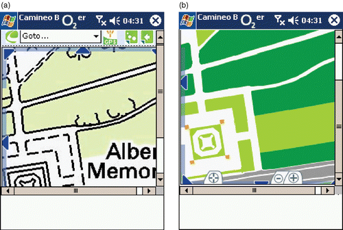
Rules and guidelines have been developed during the last few years to adapt cartographic presentations to the specific requirements of screen displays (Neudeck Citation2001). A lively discussion about new and special guidelines for map graphics regarding the very restrictive conditions of TeleCartography and the mobile internet has produced a variety of new proposals in this area since the earliest work on adaptive tourism guiding (Malaka and Zipf Citation2000, Reichenbacher Citation2003) ().
Figure 3. Topographic map (a) with no adaptations for mobile device, note fixed resolution labelling © Crown Copyright/database right 2007. An Ordnance Survey Digimap Supplied Service, and (b) topographic map in SVG with colour adaptation for mobile device © Crown Copyright/database right 2007. An Ordnance Survey Digimap Supplied Service.
Common rules or standards for cartographic presentations on screen displays are not defined yet, although some guidelines have been identified, such as in Rinner et al. (Citation2005), due in part to the continuous change in this area. Display size and resolution of state-of-the-art devices are increasing, and colour depth is no longer a restricting factor. Parameters of external conditions during the use of the application (weather, daylight) are hard to model. The needs of an interactive system have to be incorporated into the conception of the user interface, which includes soft keys as well as functionalities for various multimedia elements. As a general approach for including the various parameters within a model of map-based LBS, the concept of ‘adaptation’ (in the sense of user-dependent adaptation of a cartographic communication process) has been proposed (Reichenbacher Citation2003). This concept involves describing the links or mutual dependencies between various parameters involved and the results are connected to impacts on data modelling and cartographic visualisation. Furthermore, new cartographic presentation forms especially designed for restricted and small screen displays have been developed e.g. ‘focus-map’ (Zipf and Richter Citation2002).
For the presentation of geospatial information within LBS and on small displays, additional multimedia elements and alternative presentation forms may give potential improvements. Methods of augmented reality (AR) link cartographic presentation forms (e.g. 3D graphic) to a user's view of reality, e.g. for applications such as navigation systems. Cartographic AR applications aim to create a more intuitive user interface (Reitmayer and Schmalstieg Citation2003, Höllerer Citation2007). Kolbe (Citation2003) proposed a combined concept of augmented videos, which realises positioning and information transfer by means of video.
2.1.3.3. Users and adaptation
Experiences with LBS developments have led to various suggestions for a more user-centred system conception. Modelling parameters in the context of the user and the user's situation are seen as the fundamental elements of such user-driven approaches, which can be summarised as concepts of adaptation. The adaptation of cartographic visualisations in this context can be understood as, for example, the automatic selection of adequate scales, algorithms for adequate symbolisation, or even the change to text-only output of information in case of shortcomings in size or resolution of the output device. Adaption to the needs of the user can be expressed in the user profile or selected in advance from a list, or even entered manually so that the user can directly influence the graphical presentation (size of lettering, colours to be used, etc.) and pre-define specific map elements. Adapting the visualisation to the current situation would also include the current day and time, and the speed of travel.
2.1.3.4. Towards ubiquitous cartography
In the mapping world, the interest in ubiquitous cartography has been formalised with the International Cartographic Association's Commission on Ubiquitous Mapping (http://ubimap.net/). Currently, most ubiquitous mapping is being delivered via mobile phone systems, through the use of wireless internet zones and sensors that upload current data such as train timetables to users who have subscribed to a service. Such services are deemed to be ubiquitous when a user does not need to ‘log-in’ or consciously connect to a service.
Most recently researchers have begun to explore the possibility of using the omnipresent computer landscape for exploring our spatial environment. Fairbairn has recently described the term ‘Ubiquitous Cartography’ as a technological and social development made possible by mobile and wireless technologies (http://www.ceg.ncl.ac.uk/news/newsarchive1.htm) that receive, present, analyse and act upon map data that is distributed to a user in a remote location. Furthermore, he predicted that this new approach to maps will revolutionise the way many people interact with maps. To Ota (Citation2004) ‘the definition of ubiquitous mapping is that people can access any map at [sic] anywhere and anytime through the information network’ (p. 167).
An important application in the context of ubiquitous cartography is support for orientation and navigation functions. Yet research is still at the early development stage that must address many new challenges. The improper use of ‘ubiquitous systems’ could easily lead to information overload. A lot of different information delivered independently could overload the user and hinder effective information extraction. To avoid this the primary aim of such a system should be to concentrate on providing information about the environment without overload. At key decision points the information loading should be clarified, but everywhere else, where guidance is not implicitly necessary, additional information should be provided in an unobtrusive way. ‘User friendliness’ must be the main ambition of ubiquitous cartography applications.
The concept of ‘ubiquity’ requires an intensive analysis of appropriate forms of presentation for particular contexts. Besides new forms of visualisation like the depiction of three-dimensional space on a two-dimensional display, additional visualisation techniques need to be considered that evolve from the possibility of interconnected data exchange. The basic assumption in this context is that a harmonised combination of active and passive systems with various forms of presentation each supporting the navigation process will be productive. Radoczky (Citation2007) has shown that various presentation forms used for navigating a mixed indoor/outdoor environment lead to different mental representations, and therefore, different levels of understanding.
The development of ubiquitous cartography so far gives an indication that although maps will play a prominent role in ubiquitous environments, the nature of quick and individually tailored presentations of location-based and time-dependent information will lead to a wide variety of different cartographic forms of presentation, from schematic 2D-graphics to interactive 4D-presentations. In terms of the content delivered by these various forms, the concept of ubiquitous cartography implies individually tailored contents, which remains a major challenge for contemporary cartography.
Finally it can be argued that the term ‘ubiquitous cartography’ can encompass a wider variety of systems than the paper antecedents. Thus, the ‘UbiGIS’ conferences (http://www.ubigis.org/) have captured work on new forms of GI for communication like text directions and schematics (Ware et al. Citation2006).
2.1.4. Spatial cognition and interfaces
Mobile devices require new modes of interaction given their small screens and the likelihood that users will be outside the home/office when using them. These tough constraints on mobile computing have led to research on interaction, innovative interfaces and personalisation of LBS. Leong (Citation2004) likened the interaction with a mobile device to a conversation to which the Gricean Cooperative Principle should apply. A conversation should be sufficiently informative, true, relevant and understandable, and Leong (Citation2004) argued that these maxims apply equally to interfaces. For example, a mobile device interface that has deeply nested menus requiring many button presses to carry out a function, and which is inconsistent in its response, is not conversationally effective. This is a powerful frame of analysis to which all LBS should be subjected. In one of the few studies of this kind for LBS, Chae and Kim (Citation2004) found that task complexity significantly influenced user perceptions and behaviour in relation to information depth (in nested menus) and screen size.
2.1.4.1. Interaction with LBS
A key question when developing a LBS interface for a mobile device is the appropriate mode of interaction, given the difficulty of using keyboards and mice while mobile. The standard assumption is that LBS can use screens and buttons for interaction, in a direct analogue of a desktop computer interface. Grossniklaus et al. (Citation2006), however, experimented with digital pens that allow users to point and click on paper maps to get information and directions. The system uses the Anoto approach to reference a huge virtual space, parts of which can be reserved by developers for links to digital content, presentations, maps and so on. Ordinary paper is overprinted with a spatially unique, semi-invisible patterns of dots to link the surface of the paper with the virtual space, and therefore to link to the selected resource placed there by the developer. Audio feedback allows the system to direct users to the right place on the map to see the results of a search. Given the ease of use of pen and paper, such interfaces could be important in the development of mobile applications, if the cost of the pen became low or the technology was incorporated in mobile devices. By contrast, Strachan et al. (Citation2005) developed a location-aware music player (‘gpsTunes’). Rogers and Muller (Citation2006) envisaged much richer interactions with sensor networks in the future, and explore the way that children interact with them. A further new challenge is the development of collaborative filtering of points of interest (Dunlop et al. Citation2004) based on previous user experiences.
2.1.4.2. VR/AR interfaces to LBS
A wide variety of research has been conducted on ‘standard’ interactions with mobile devices for LBS. Paterno (Citation2003) reviews progress, while MacKay et al. (2005) showed that scrollbars are much less effective than drag and go interfaces. However, a number of researchers have explored new virtual reality (VR), augmented reality (AR) and mixed reality (MR) interfaces for LBS beginning with Rakkolainen and Vainio (Citation2001) who developed an early web-based VRML-based 3D city model. Rietmayer and Schmalstieg (2003) developed an AR interface to building information, updating the information via visual tracking of pre-placed fiducial markers. Rehman et al. (Citation2005) developed an AR system using a head-mounted display (HMD) and a handheld ultrasound location system in which the location of terminals offering a personal virtual desktop was overlaid on the user's field of view, and the handheld tool allowed control over the virtual desktop. The lessons learned from post-test questionnaires showed that users’ mental models can be influenced by the LBS, that visualisation reduces the call on the user's working memory, and that complexity is an enduring inhibitor to LBS use.
Suomela et al. (Citation2003) tested Walkmap 2D and 3D, a navigation interface for HMD delivery, finding that 3D visualisations are not universally useful for navigation. By contrast Pingel and Clarke (Citation2005) found users indifferent to 2D and 3D map display in their Geographic Referenced Graphic Environment (GEORGE) system using a HMD around the UC Santa Barbara campus. Moore (Citation2006) developed a tangible AR application for browsing street map book pages in which the user rotates a cube as a substitute for finding the right page transition. Narzt et al. (Citation2006) suggested that the ubiquitous computing requirements of AR make the car the best focus for AR-oriented LBS.
Liarokapis et al. (Citation2006) developed AR and VR interfaces in the Locus project, which uses GPS positioning using the web-based Camineo platform. The AR application is based on ARToolkit and displays location-sensitive information over the camera preview image on the mobile device. The VR application uses the Cortona VR plugin for the Pocket Internet Explorer to present location-sensitive information in the virtual world as the user moves. Tokunaga et al. (Citation2004) blended AR and VR to make MR systems based on middleware that hides system complexity for developers.
2.1.4.3. Geo-presentation for mobility
Presentation of ‘you-are-here’ maps and navigation directions on mobile devices involve portrayal, generalisation and appropriate content questions with a GI dimension. May et al. (Citation2003) studied the information requirements of pedestrians when navigating, finding that 72% of the cues for navigating were landmarks and that the need for cues was most important at decision points, especially to develop trust in the system by the user. Bartie and Mackaness (Citation2006) developed the speech-based prototype ‘Edinburgh Augmented Reality System’ (EARS) to select and display features of interest (FOI) as they become visible (and not just physically close) to the user during their journey.
Presenting maps on mobile devices involves portrayal mechanisms designed for mobility. Yoshihide et al. (Citation2005) developed a location-based active map transformation system that brings current location and FOI into the screen display by automatically culling inappropriate objects. Ware et al. (Citation2006) developed a system to draw map schematics rather than fully representative maps as a way to reduce the cognitive overhead on the user.
Generalisation of GI in order to display data effectively on mobile devices is also vital to geopresentation. Follin et al. (Citation2004) developed a context-aware generalisation tool that simplified the map as required by the current user activity. Edwardes et al. (Citation2005) showed how the WebPark system could carry out model generalisation (e.g. filtering) and view generalisation (e.g. aggregation) from content databases so that the data was presented effectively. This technique was used by Edwardes et al. (Citation2003) to present species information to visitors using the WebPark LBS in the Swiss National Park.
2.1.4.4. Acceptance
A final key issue for spatial cognition and interfaces of LBS is acceptance by users. The key problem when studying acceptance is the question of whether to assess LBS use in a laboratory (controlled, safe, reproducible) or ‘in the wild’ (semi-controlled, unpredictable, unreproducible). Kallio et al. (Citation2005) compared the two methods of interaction testing, finding that non-contextual use, e.g. interface assessment on the service is less distinct between the two environments than contextual use, where the context or situation of use strongly influences use. This view was shared by Kangas and Kinnunen (Citation2005) who drew upon the experience of a large usability lab at Digia, where they carried out work for mobile operators and software developers.
Kaasinen (Citation2005) carried out a large study of attitudes to LBS, and she collated a set of recommendations for LBS design, including at a high level the need for usability, utility and user trust. Specifically users requested:
-
instant on/off
-
dynamic scale adjustment
-
well designed labelling (of landmarks)
-
push services that are under user control, and be refined or cancelled easily
-
reliable services, especially ones that are only used occasionally
-
support for content creation
Hinz et al. (Citation2004) argued that the key to acceptance was personalisation: mobile personalisation may be emerging as part of mobile social networking, where individuals may choose (or be collectively assigned) a specific role in the emergent community. Searby (Citation2004) reviewed concepts of (mobile application) personalisation and suggested that personal profiles might help avoid the limitations of ‘stovepipe’ systems each invented separately with their own monolithic workflow.
2.1.5. Information science
Information science is concerned with issues of information need, management and retrieval, all of which are taken to extremes in LBS. In an era before widespread information literacy (it seems to be lagging behind digital device distribution, and is still rarely taught), information design is of crucial importance (Jacobsen Citation1999). Information design requires an understanding of information needs as information overload readily sets in if needs are not carefully considered. In a study of organisational use of Blackberry push email clients, Allen and Shoard (Citation2005) showed that mobile information overload was mitigated by the better distribution of workload over the day, and by the use of filtering and approximation (responding in a non-precise way). Much further work is needed to understand information literacy needs for mobility.
Mobile information retrieval (‘mobile search’) is a crucial new information science that forms the focus of importance to LBS. Some early experiments on mobile search were conducted using simple assumptions about the document location (simple x, y point) and query domain (fixed size circular search), e.g. Kokono Search (Yokoji et al. Citation2001, Pramudiono et al. Citation2002). These experiences led Google to include location searches in Google Maps. However, the mobility of the user requires the use of dynamic concepts of document location and query domain. Tezuka and Tanaka (Citation2005) proposed a spatio-temporal approach in which attribute matching for addresses (space) and temporal interval expressions (time) were computed to find the best results for the (spatio-temporal) search criteria. Huang and Jensen (Citation2005) proposed a method for responding to ‘in-route nearest-neighbour skyline queries’, in which the query is constrained to the road network forward from the current position. Gedik and Liu (Citation2006) extended this approach by designing the distributed and scaleable MobiEyes system in which the processing of the query is partitioned between client and server using an optimisation method.
Mobile search will also need novel interfaces to allow the user to carry out searches on the move. Du and Crestani (Citation2004) suggested that voice-activated querying for mobile devices might offer the ideal interface, and the experimental outcomes suggested that this was feasible as queries were consciously vocally formulated ‘semantically’. Ryoko and Kazutoshi (Citation2006) designed a system to capture map panning and zooming operations for use as continuous range queries to define search zones. The key finding was that it is important to subdivide a sequence of map operations so that a search can be associated with an internally consistent semantic, e.g. zooming steadily into a single place.
Mobile search also requires new IR theory and practice to handle the characteristics of space and time in situated queries. Raper (Citation2007) proposed a theory of geographic relevance in which the query is modelled as a ‘span of attention’ and the information resource is modelled as an ‘area of influence’: new operations to explore the multidimensional intersections of these two zones are discussed. Purves and Clough (Citation2006) outlined the design of the SPIRIT, a prototype spatially aware search engine designed to evaluate queries with a theme, spatial relationship and location. Query results are produced by text ranking methods and geometric calculations based on footprints, though users found it difficult to assess ‘spatial relevance’ without local knowledge. Hattori et al. (Citation2006) suggested that query expansion could be carried out using the geographic properties of the context, e.g. absolute location, nearby objects or context history. This is an approach with significant potential.
Mobile search can be push or pull in nature, with the former sending updates to the mobile device automatically and the latter dependent on user generated queries. Push services were largely discredited in the late 1990s as users said they did not want to receive unsolicited content. However, push services have been re-invented as targeted ‘geo-intelligence’ with the arrival of more sophisticated devices and interfaces. Hence, Hariharan et al. (Citation2005) suggested that LBS are enhanced by associating web content with location by matching current (e.g. GPS) position or orientation (compass) with personalised GI content. Krumm (Citation2005) outlined the design of the interactive Geographic Context Browser that selects web content near to a GPS track by filtering recursively over the different aspects of content.
2.1.6. Ubiquitous computing
Ubiquitous computing was forecast to be the ‘third wave’ in computing, or ‘… the age of calm technology, when technology recedes into the background of our lives” by the ‘father of ubiquitous computing’, the late Mark Weiser (Citation1991). In ‘The Computer for the twenty-first Century’ he assumed that in the near future many computers would be omnipresent in our everyday life and that they would be interconnected in a ubiquitous network. We now see the reality of this vision in 2007 with every type of computing in the form of handheld PCs, mobile phones, wireless sensors, radio tags (RFID) and WiFi present in our lived environment. Designers of ubiquitous systems envision seeding private and public places with sensors and transmitters that are embedded into objects and hidden from view, providing for the deployment of things like ‘Audio Tags’, which play an infrared sensor-triggered message once a person is within a pre-determined proximity. Ubiquitous computing overlaps with location-based services and provides some foundational technologies that will be critically reviewed in this section.
The 2006 International Symposium on Ubiquitous Computing Systems characterised ‘UbiComp’ as any computing environment that can “efficiently support the 5C (Computing, Communication, Connection, Contents, Calm) with 5Any (Anytime, Anywhere, Any-network, Any-device, Any-service)’ (uKoreaForum Citation2006). End users of UbiComp should be able to acquire and deliver information through networks of many computers at the same time and have the sense of working in a single environment without being overburdened with reconfiguration issues. Saha and Mukherjee (Citation2003) identified four broad areas of pervasive computing: devices, networking, middleware and applications, each of which will be discussed below.
UbiComp devices now span an extraordinary range of hardware devices, with more being released all the time. These devices can be divided into four main groups (excluding desktop equipment): embedded devices, tablet PCs and micro-laptops, PDAs and smartphones. Embedded devices are those that detect and maintain context and/or position on dedicated devices, e.g. safety of life beacons, tracking devices, active badges, personal navigation devices, cameras and the like. Tablet PCs or micro-laptops with context detection and/or positioning are increasingly used by parking attendants, ticket inspectors, meter readers and so on to pre-cache geographically relevant datasets. PDAs and smartphones can now participate in UbiComp architectures as both come with the necessary context (e.g. WiFi) or positioning (GPS) sensors, and have sufficient processing resources to exploit them. GPS is a classic example of UbiComp principles in its seamless integration with devices such as laptops, PDAs, mobile phones and cameras. Furthermore, the GPS satellite constellation has reliable and global coverage, thus complimenting the UbiComp goal of everywhere, anytime computing, though there are availability issues in urban and indoor environments, as previously noted.
In the UbiComp environment, networking is used as a means to seamlessly transmit information among interconnected devices. This type of networking, called inter-networking, is an interconnection between heterogeneous networks, and is becoming more important as the demand for shared resources increases. Here, data is transferred from one network to another through interface devices such as bridges, gateways or routers. An example of inter-networking is PervNet by Saha et al. (Citation2002), which is a heterogeneous network utilising multiple connection technologies such as Ethernet, FDDI, ATM and TCP/IP. Another area of developing importance in UbiComp is mobile ad-hoc networks (MANETS), when groups of mobile devices spontaneously interconnect. Dolev et al. (Citation2003) outlined the GeoQuorums algorithm for managing shared memory in ‘focal points’–places where many mobile clients are to be found such as road junctions or observation points. Tei et al. (Citation2005) introduced the geographically bound mobile agent (GBMA) concept to theorise the movement of a GBMA as it tracks its designated location.
As with distributed computing, the UbiComp environment requires middleware to interconnect the components that comprise the networking layer and the user application layer (Saha and Mukherjee Citation2003). The middleware's responsibility is to provide users with the computing and communication facilities for their current environment. Fujitsu research and development of software for internet and mobile networks is an example of such middleware for the UbiComp environment and is composed of optimum network selection, seamless roaming and plug-and-play services which enable users to access a variety of services anytime and anywhere (Kawai et al. Citation2004). The Fujitsu research has focused on how to select the most suitable network and automatically connect to it, how to transfer from one network to another, and how to implement plug-and-play functions for services. Meier and Cahill (Citation2002) introduced an event-based middleware service named scalable timed events and mobility (STEAM) that has been designed for mobile applications such as traffic management. STEAM asynchronously interconnects the components, which include a distributed application and heterogeneous environment.
By contrast Bellavista et al. (Citation2003) developed the SCaLaDE system that implemented mobile proxies to follow the user and device around so that context-specific services would always be provided. Claude et al. (Citation2006) designed the Geo-Located Web Services Architecture to permit the satisfaction of client service requests at the geographically closest server. At present there is a major dichotomy between mobile operator middleware geoservices offered to developers and innovation outside the disciplines of these networks. This will take time to change: costs and maintenance on mobile operator networks need to have immediate and proven returns on investment, which is hard to demonstrate with new technologies.
Over the last few years there has been much research both in academia and in industry being conducted on advanced UbiComp and pervasive computing projects. For example, project Aura, a campus-wide ubiquitous computing effort, was developed by the School of Computer Science at Carnegie Mellon University (Sousa and Garlan Citation2002). Aura aimed to design and implement a software architectural framework for user mobility in UbiComp environments. The Aura architecture is composed of a task manager, service suppliers, a context observer, an environment manager and connectors. All components’ functions aim to accommodate dynamically changing resources when a user moves from one computing environment to another (Sousa and Garlan Citation2002). The EasyLiving research project of Microsoft Research's vision group aimed to develop architecture and necessary technologies for UbiComp environments (Brummitt and Shafer 2001). This project focused on a geometric model for improving the user's experience of systems that are composed of multiple devices and heterogeneous services and information sources.
Two of the most significant developments in location-based UbiComp are the HP Cooltown project and the Intel PlaceLab initiative. Cooltown was one of the first architectures to be defined in this area (Kindberg Citation2000) and proposed to embed web servers in devices so that they could embody their function and surroundings, and respond appropriately. Hightower and colleagues at the Intel PlaceLab have developed architectures for positional fusion and the integration into applications (Hightower et al. Citation2002), initially through the Location Stack, a model based on the seven layer Open Systems Interconnect (OSI) model. PlaceLab has subsequently developed extensive software to allow mobile devices to discover their own location through the use of WiFi hotspot, GSM cells and FM radio footprints, which they have argued is sufficient for a certain class of applications (Chen et al. Citation2006, Hightower et al. Citation2006).
The term ‘context-aware computing’ in ubiquitous or pervasive computing has been a major research interest for many researchers and research institutes and was introduced by Salber et al. (Citation1999) with their work on the Context Toolkit. They defined the minimal set of necessary contexts with five W's (Who, What, Where, When and Why) and presented the knowledge of sensing, capturing and interacting with user mobility and location information. The Context Toolkit framework is being used by a number of applications. The goal of context-aware computing is ‘to acquire and utilise information about the context of a device to provide services that are appropriate to the particular people, place, time, events, and so forth’ (Moran and Dourish Citation2001). Beigl et al. (Citation2002) argued in favour of ‘spatially aware communication’ in which all mobile data is communicated based on the relative location of mobile devices in the network, and they introduced a semantic model of users and organisational structures called the ‘location tree’.
More recently full context architectures have been proposed (Coppola et al. Citation2005) that integrate sensors, user interface, personalisation and mobile search filtering. Siljee et al. (Citation2005) review and evaluate context architectures e.g. Context Awareness Subsystem, Context Toolkit and the Service-oriented Context Aware Middleware systems. On top of these architectures a variety of models have been proposed including how to form mobile communities with wireless devices in public spaces e.g. trains (Pichler Citation2004) and the construction of collaborative context models based on user movement trails (Spence et al. Citation2005). Finally, applications that take account of context are evolving including location-based reminders called PlaceIts (Sohn et al. Citation2005) and intelligent location-sensitive travel recommender systems (Ricci Citation2002) and a variety of mobile guides, e.g. WebPark with its ‘look ahead’ simulator for walkers to predict the ‘soon to come’ context for walkers, cyclists and drivers (Mountain and MacFarlane Citation2007).
Finally, there is an explosion of activity and interest in the use of Web 2.0 AJAX technology to build location intelligence applications. These applications use the Javascript engine in web browsers and lightweight calls to the server to provide efficient and highly interactive web applications. With the release of sophisticated web browsers like Opera for mobile devices and the availability of location services on the device, some of the next wave of LBS applications are likely to be AJAX-based.
The future research challenges in UbiComp focus on the development of all components to support intelligent UbiComp applications. Development of personalised adaptive service methodologies and dealing with data semantics through ontologies are examples of research challenges. Security and privacy in sharing personal information is also of interest to many researchers. As the number of users and devices on the network rapidly grows, the network infrastructure, smart sensors and various middleware pieces are open research topics for the development of distributed mobile computing.
2.2. User issues of importance to LBS
2.2.1. Business models
There are still very few substantive studies on LBS business models, partly because there are still very few successful deployments from which lessons can be learned, and partly because successful implementers want to capitalise on their competitive advantage. However, LBS are services like any other and so broadly the same range of business models are available, with the same success factors: LBS developers still need channels to reach customers and collect revenue; there still need to be demonstrable profit margins, given the cost of finance that applies in each case; and the service has to be compelling enough to drive repeat use or recommendations.
Many commentators on LBS have assumed that the dominant (or even the only) channel for business-to-consumers (b2c) services would be through existing mobile operators (Balaji et al. Citation2005). At present most mobile operators outside Japan (Grajski and Kirk Citation2003) are delivering applications to subscribers using web portals optimised for mobile device browsers. Given the small size of mobile device browsers, position on the portal menu is important to the likely use of the service (higher items get many more hits). However, without early success the operator may relegate a LBS to the bottom of the portal listing or a sub-menu. This can lead to negative feedback: a poorly designed or non-functional LBS may not achieve expected revenues; the service is then relegated to a less prominent position on the portal and performs even less well; and eventually the service is closed down due to poor performance. Beasley et al. (Citation2006) detailed the business and implementation requirements associated with the BREW LBS application development environment built around the gpsONE chip produced by Qualcomm. There are other channels available to LBS, and innovation in this area may be the key to eventual commercial success. For example, mobile devices that are pre-configured with the service can be rented by service providers at the point-of-sale for a related service, e.g. cycle hire or tour guide. LBS can also be downloaded to user devices as applications, e.g. java midlets from the mobile web, e.g. LoVEUS, Karagiozidis et al. (Citation2003). As there are security and payment implications for this process if done when mobile, this model may be more suitable for business-to-business (b2b) LBS. Finally, some b2b LBS, e.g. indoor positioning systems, are installed sensor systems (such as Ultra Wide Band, WiFi or RFID) that track items within a specific environment, and the channel to the customer is similar to those used by other facilities management business models (Cadman Citation2003).
LBS also need to realise appropriate profit margins through the delivery of added value. This is, however, difficult when users of b2c services expect ‘free’ services financed through advertising or sponsorship: there is no margin on free! Karagiozidis et al. (Citation2003) argued that the key requirements that a consumer has for a value-added service are benefit, speed, price and ease of use. Location is a kind of benefit, which means that LBS developers have been looking for innovative ways to add value with location. A variety of solutions have appeared on the market leveraging location, such as golf course guiding (http://www.sureshotgps.com/) and exercise monitoring (http://www.allsportgps.com/). It is also possible to add value to location with exclusivity, e.g. by partnership with an organisation with ownership of, or access to, a specific area such as a theme park or protected area (http://www.camineo.com/). This kind of LBS proposition and its precise value to users is crucial to the sustainability of b2c LBS. For b2b LBS the profit margin is a more conventional function of costs and revenues, although Cadman (Citation2003) argued that business users are more focused on dependability than functionality.
The goal of compelling applications is a crucial one for LBS. There are no direct competitors for location-sensitive device-delivered services: LBS have to ‘substitute’ existing analogue approaches, e.g. the use of cheap, durable and easy-to-use paper maps for the most part. If there are competitors already in the market, at least this demonstrates the viability of the service; if there are none then the first to market has to educate customers and bear the costs. The best way to address this requirement is to innovate in an application area where users are willing to experiment.
2.2.2. GI mobile content
There are also a number of challenges for the production of GI mobile content that are important to LBS. Firstly, there are some standardisation activities of importance to LBS in both internet and telecommunications. In the internet standardisation field the internet engineering task force (IETF) debated a Spatial Location Protocol in 2000 to define the way that applications would spatially reference resources, but this was not adopted (Korkea-aho and Tang Citation2001). However, the subsequent IETF GeoPriv Task Force (RFC 3693) has developed a protocol-free approach to the authorisation of GI release in client-server environments that is integrated with the presence information data format (PIDF) (Tschofenig et al., Citation2006). GeoPriv RFC 3693 is mainly focused on the way that the location of a human being using a connected device is released to others through LBS or presence services such as chat or internet telephony. In the World Wide Web Consortium (W3C) arena the Mobile Web Initiative has defined MobileOK protocols to ensure that web applications work properly on mobile devices. Finally, the Web3D consortium has an X3D-Earth Working Group to develop geo-referenced 3D models accessible over the web.
Although IETF, W3C and Web3D all have working groups concerned with data relevant to LBS, they have ceded leadership in GI standardisation to the OGC who have in turn developed technology that is conformant with web standards. OGC is responsible for the development of the Geography Markup Language (GML), Web Feature Servers (for vector data), Web Map Servers (for geo-referenced imagery) and Open Location Services (openLS) (with the Open Mobile Alliance, OMA), which is of direct relevance to LBS. The OpenLS core services (also known as the GeoMobility server) is a platform for the delivery of LBS over telecommunication networks and consists of the five Directory, Gateway, Location Utility, Portrayal and Route services (Mabrouk Citation2005). Hansen et al. (Citation2006) defined a further sixth OpenLS navigation service that represents landmarks in a cognitively rich form for systems that generate route directions. Zipf and Häussler (Citation2004) also proposed extensions to OpenLS to enrich the semantics available for routes and tours. This opens the way for more sophisticated LBS that are also delivered using the robust and standardised web service approach.
One key function that is rarely discussed is geospatial content management. Large-scale LBS delivered through mobile operator web portals are served through LBS platforms like deCarta's Drill Down Server or Geodan's Movida and backed by large database management systems. Small-scale LBS are rarely built on geospatial content management systems (geoCMS): typically the data is stored in file structures on the client because of the limited number of repositories capable of storing geospatial and multimedia data. There are some geoCMS like TikiMaps and PrimaGIS that are integrated closely with the Mapserver Web Feature Server; others such as the Camineo geoCMS are built in java.
Shafer (Citation2003) argued for a common way to access location data and suggested that a generic ‘location authority’ providing an API, a generic location reference and federation of location authorities would be useful for LBS. However, in the rush to develop LBS there has not been time to develop new fundamental concepts: most LBS use application-specific location referencing. Boucelma and Colonna (Citation2005) suggest that online geoservice mediation is required to permit spatial data integration, and that it cannot be done satisfactorily by logic.
Finally, there are some forms of new GI mobile content such as spatially encoded video (McCarthy et al. Citation2007) that have not become commodities at this time and yet could drive considerable change as and when released. Sato and Masunaga (Citation2005) outlined a novel approach to LBS data capture by collecting gyro-stabilised video of city tower blocks, recognising the buildings in the image by ‘location association’ from GPS, looking them up in a database and creating location-indexed video.
2.2.3. Legal, social and ethical dimensions
The introduction of handheld, internet-connected devices capable of positioning, tracking and navigating the user potentially changes a great deal in social and business affairs: such a device is a new personal artefact for managing ‘space and place’ equivalent to a watch or a diary for ‘time and events’. As such it is clear that the effects of the introduction of such an artefact will be wide-ranging, especially when combined with mobile communications. Hitherto most people have been unable to position themselves precisely outside the places they know well, and no one has been able to find their location remotely. This new situation has both negative and positive implications: negative because of the potential for surveillance and the exercise of power over individual movement (Dobson and Fisher Citation2003), and positive because of the potential to guide and the new social possibilities. This subject has already attracted a huge range of research, but much remains to be done as services and regulations develop hand-in-hand.
At present most LBS are offered by service providers with a well-defined relationship to their customers, to serve specific needs such as a mobile guide. These services are often provided by renting devices in formalised settings (e.g. National Park or museums), and the legal, social and ethical implications are not severe. Current data protection legislation (in Europe) and contract terms and conditions provide specific legal protection for users, though these have some limitations (Price Citation2004, Wong Citation2004). However, the likely extension of these services to personal devices and generalised social settings will bring new challenges as the consequences of location disclosure or errors in guiding may become serious. MacGregor (Citation2003) asked the question ‘Customer service or invasion of privacy’ in respect of services like LBS: ensuring that this balance is right is the secret to progress in this area.
Some researchers have focused on technical measures to ensure that users are protected in the event of a failure of management or regulation. Krumm (Citation2007) carried out an experiment to identify the home locations of LBS users from tracklogs with only limited success (finding around 5%), and compared ‘last destination’, ‘dwell time’ and ‘largest cluster’ algorithms (similar performance). Kido et al. (Citation2005) suggested the use of location ‘dummy data’ to spatially blur the location of the user. Cheng and Prabhakar (Citation2004) investigated the relationship between location uncertainty and privacy, suggesting that the level of location disclosure should be precisely related to the need. Duckham et al. (Citation2006) developed a formal model of location ‘obfuscation’ in which they explore the options for an ‘attack’ on location information through global or local refinement. Others have suggested that the way to preserve privacy is to ‘anonymise’ location in an ‘identity disconnect’ process using access control (Youssef et al. Citation2005b) or authentication (Jorns and Bessler Citation2004). Kindberg et al. (Citation2002) considered the opposite problem, i.e. the ‘spoofing’ of presence and suggested that ‘Presence should be proved by proximity to a known reference point within a place’ (p. 14).
Privacy is also an important issue in UbiComp and may be the one that significantly impacts its long-term success. Westin defined information privacy as ‘the claim of individuals, groups or institutions to determine for themselves when, how, and to what extent information about them is communicated to others’ (Westin Citation1967). Hong and Landay (Citation2004) described an analysis of end-user needs and application developer needs for privacy-sensitivity on UbiComp environments and developed Confab, a toolkit for building the privacy-sensitive UbiComp applications by providing a framework and mechanism for managing privacy.
A number of case studies in privacy and LBS have produced valuable insights into users’ views. Many of these studies have found that if the capability of the LBS is attractive and the protection acceptable to them, then their privacy concerns reduce (Barkhuus Citation2004). Kaasinen (Citation2005) conducted a comprehensive survey of LBS services with users in Finland, commenting in conclusion that ‘the users turned out to be quite trusting towards service providers in issues related to privacy protection and reliability of the services. User acceptance of push services was high. These user attitudes form a good basis for introducing location-aware mobile guides’ (p. 48). Kotaro et al. (Citation2006) reported experiences in the setting up of the Geo Note social network, and Iachello et al. (Citation2005) outlined an experiment with Reno (a location-enhanced messaging application for the Nokia Series 60 phones) in which they explore the apparent need for individuals to engage in various sorts of deception about location to manage their relationships with others. This behaviour will have to be modified substantially in a world where location information is commodified and exchanged freely, though not all the changes would be for the worse! All these studies illustrate the need for the development of trust relationships with providers as a key element in increased acceptance of LBS.
Ahas and Mark (Citation2005) introduce the social positioning method (SPM) in which they explore the use of mobile phone positioning data in public surveys, e.g. in the use of a bridge or (aggregate) tourist destination surveys. Dearman et al. (Citation2005) carried out a study of rendezvousing with LBS, finding that location information changed the behaviour of the waiting partner: ‘when their partner appeared to be lost or not making progress, it was very disconcerting to the waiting partner because they did not have enough information to determine what the problem was. This uncertainty was strong enough in some cases to actually draw the waiting partner away from the rendezvous location.’ This is one small example of the way that mobile location information could re-draw social interactions on a wide scale.
There is also a broader analysis of the role and implications of LBS focused on the relationship between agency and space in society that follows from the ‘digital transition’ of the last decade (Pickles Citation1999). Dodge and Kitchin (Citation2005) studied the development of life-logging, suggesting that the technology needs to incorporate the ability to selectively forget, and that this is a vital emancipatory process in a society potentially moving towards greater surveillance and individual ‘sousveillance’. McCullough (Citation2006) suggested the need for ‘socially centred’ situated computing so that LBS users could contribute to social capital through providing ‘urban markup’. Laurier (Citation2000) wondered ‘Why people say where they are during mobile phone calls’, suggesting the importance of location in conversational ordering.
2.3. Synthesis
From the foregoing review and analysis it is clear that there is already a huge and sophisticated body of research on LBS. However, it is poorly integrated, and this article aims to provide a synoptic view to all the research communities that are critically engaged with this work.
A few researchers have attempted design statements or taxonomic overviews of LBS, which are reviewed here. Lopez (Citation2004) defined LBS as ‘consist(ing) of a broad range of services that incorporate location information with contextual data to provide a value-added experience to users on the Web or wireless devices’. He also charted the very wide range of players required in most LBS applications, including:
-
Infrastructure providers
-
Network and handset positioning
-
LBS platform vendors
-
LBS service providers
-
Content providers
-
Wireless and web portals
Lopez (Citation2004) suggested that the key development with LBS was the ‘transformation of telecommunications networks to IP-based service environments’, although it has become clear subsequently that LBS have been developed in a wider range of contexts, e.g. indoor positioning.
Jiang and Yao (Citation2006) reviewed LBS from a GIS perspective, noting that LBS are much more demanding in hardware and software terms than GIS, that they are much more dynamic and that they need to integrate more data types. They note that user needs modelling, location modelling, context modelling and geospatial data modelling all that are required to develop LBS. Jiang and Yao (Citation2006) presented a research agenda in which they argue that the key challenges for LBS are developing for naïve users, spatio-temporal data mining, real-time generalisation, inter-operability and privacy/social issues. They speculate that GIS may become more like LBS in time as computer applications become more ubiquitous and distributed in nature.
The challenges of LBS have inspired a wide range of research initiatives, some of them very large in scale. One of the first was the Guide project (Davies et al. Citation1999) in which portable Guide units were able to obtain location-specific information for a hierarchy of service scopes through wireless beacons placed around the City of Lancaster, UK. The HP Cooltown system was described by Kindberg (Citation2000) and focused on associating web pages with real entities. Schilit et al. (Citation2003) outlined the founding principles of the interdisciplinary PLACE Lab which aims to bring LBS to the largest number of people, in as many situations as possible, through the fusion of position determination technologies and the development of new applications. In a later work Canny (Citation2006) outlined ‘immersive’ approaches for developing LBS that prototypes applications and then exposes them to users to help evolve the applications towards greater usability. Such approaches offer LBS developers great potential for developing highly egocentric applications.
There are relatively few surveys of LBS experiences to inform service design and development. Zipf and Joest (Citation2004) surveyed potential LBS users about their concepts of ‘nearness’, the map presentation and the type of content likely to be of interest. Few definitive judgements were clear at this stage. Raper (Citation2006) reviewed the operational constraints on successful LBS deployment based on experience from ‘live’ LBS implementations, and highlighted context systems, positional fusion and application development platforms for LBS as key challenges for LBS. Raper (Citation2006) contrasted proprietary (and optimised) systems such as that used to deliver the Japanese KDDI EZ Naviwalk system with the more open client-server web services framework used to deliver the Camineo Guide application.
There is also a critique of LBS that divides into two parts. Firstly there are some authors who argue that LBS are misconceived and simplistic and that much richer models of place are needed before they will be of use (Harris Citation2006). Secondly, some have argued that LBS open the way for ‘geoslavery’ (Dobson and Fisher Citation2003) through the potential for tracking and controlling individuals. Such a critique is a valuable driver for LBS research, and opportunities to engage social theorists and sociologists in LBS research, e.g. Urry (Citation2006) who writes about the sociabilities of travel and the role of mobile communications technology.
3. Conclusion
The outstanding research issues are many and interdependent in this field. A non-exhaustive list of topics of significance is presented in the table below:
As indicated by this extensive review, LBS are extremely complex applications. This complexity lies in the inter-dependencies of the many elements of LBS architectures and in their real-time nature. Significant research, development and commercial challenges remain, and the number of deployed LBS is still low globally. However, as computing moves off the desktop, location will become a critical driver of ubiquitous and situated services, and a whole generation of new applications are on the horizon. The long-term goal of the Journal is to document and drive these changes by informing the debate and stimulating the growth of a new community.
Acknowledgements
The Editorial team of JLBS wish to thank the publishing team at Taylor and Francis for their support in establishing the Journal, the members of the Editorial Board who have reviewed this article and current and prospective reviewers, whose work is essential to the success of the Journal.
Related Research Data
References
- Abraham , T and Roddick , JF . 1999 . Survey of spatio-temporal databases . GeoInformatica , 3 : 61 – 99 .
- Ahas , R and Mark , Ü. 2005 . Location based services–new challenges for planning and public administration? . Futures , 37 : 547 – 561 .
- Allen , DK and Shoard , M . 2005 . Spreading the load: mobile information and communications technologies and their effect on information overload Paper 227 . Information Research , 10 : 1 – 16 .
- Ashbrook , D and Starner , T . 2003 . Using GPS to learn significant locations and predict movement across multiple users . Personal and Ubiquitous Computing , 7 : 275 – 286 .
- Balaji , TS , Landers , B , Kates , J and Moritz , R . 2005 . A Carrier's Perspective on Creating a Mobile Multimedia Service . Communications of the ACM , 48 : 49 – 53 .
- Barkhuus , L . 2004 . “ Privacy in location-based services, concern vs. coolness ” . In Workshop On Location Systems Privacy And Control (MobileHCI 2004) Glasgow, , UK
- Bartie , PJ and Mackaness , WA . 2006 . Development of a speech-based augmented reality system to support exploration of cityscape . Transactions in GIS , 10 : 63 – 86 .
- Beasley , D , Ross , B and Salmon , M . 2006 . “ getGoingwith Verizon Wireless. ALBS platform: 3rd Party Developer Program and Technical Overview ” . In BREW Conference 2006 , San Diego, CA : Qualcomm .
- Beigl , M , Zimmer , T and Decker , C . 2002 . A location model for communicating and processing of context . Personal and Ubiquitous Computing , 6 : 341 – 357 .
- Bellavista , P , Corradi , A and Giannelli , C . 2004 . “ Mobility prediction for mobile agent-based service continuity in the wireless internet ” . In First International Workshop on Mobility Aware Technologies and Applications: MATA 2004 , Florianopolis, , Brazil : Springer .
- Bellavista , P , Corradi , A , Montanari , R and Stefanelli , C . 2003 . “ Policy-driven binding to information resources in mobility-enabled scenarios ” . In 4th International Conference on Mobile Data Management 2003 , Melbourne, , Australia : Springer .
- Bhattacharya , A and Das , SK . 1999 . “ LeZi-Update: an information-theoretic approach to track mobile users in PCS networks ” . In 5th Annual ACM/IEEE International Conference on Mobile Computing and Networking , New York : ACM .
- Blunck , H , Hinrichs , KH , Sondern , J and Vahrenhold , J . 2006 . “ Modeling and engineering algorithms for mobile data ” . In 12th International Symposium on Spatial Data Handling Edited by: Riedl , A , Kainz , W and Elmes , G . Wien, , Austria
- Boucelma , O and Colonna , F-M . 2005 . “ Mediation for online geoservices ” . In 4th International Workshop on Web and Wireless Geographical Information Systems: W2GIS 2004 , Goyang, Korea : Springer .
- Brimicombe , A and Li , Y . 2006 . Mobile space-time envelopes for location-based services . Transactions in GIS , 10 : 5 – 23 .
- Brumitt , B and Shafer , S . 2001 . Better living through geometry . Personal and Ubiquitous Computing , 5 : 42 – 45 .
- Bryant , R . 2004 . “ Lessons learnt in assisted GPS ” . In 2004 International Symposium on GNSS/GPS Sydney, , Australia
- Burghardt , D , Neun , M and Weibel , R . 2005 . Generalization services on the web- classification and an initial prototype implementation . Cartography and Geographic Information Science , 32 : 257 – 268 .
- Burnett , G , Smith , D and May , A . 2001 . “ Supporting the navigation task: characteristics of ‘good’ landmarks ” . In Annual Conference of the Ergonomics Society
- Burnett , GE and Lee , K . 2005 . “ The effect of vehicle navigation systems on the formation of cognitive maps ” . In Traffic and Transport Psychology: Theory and Application , Edited by: Underwood , G . Amsterdam : Elsevier .
- Burnett , GE , Summerskill , SJ and Porter , JM . 2004 . On-the-move destination entry for vehicle navigation systems: unsafe by any means? . Behaviour and Information Technology , 23 : 265 – 272 .
- Cadman , J . 2003 . “ Deploying commercial location-aware systems ” . In Proceedings of the 2003 Workshop on Location-Aware Computing (UbiComp 2003) Seattle, WA, , USA
- Canny , J . 2006 . “ A “technology probe” approach to designing location-based services ” . In BREW Conference 2006 , San Diego, CA : Qualcomm .
- Casares Giner , V , Garcia Escalle , P and Mataix Oltra , J . 2002 . Modeling mobility tracking procedures in PCS systems using stochastic activity networks . International Journal of Wireless Information Networks , 9 : 213 – 226 .
- Chae , M and Kim , J . 2004 . Do size and structure matter to mobile users? An empirical study of the effects of screen size, information structure, and task complexity on user activities with standard web phones . Behaviour and Information Technology , 23 : 165 – 181 .
- Chen , MY , Sohn , T , Chmelev , D , Haehnel , D , Hightower , J , Hughes , J , Lamarca , A , Potter , F , Smith , I and Varshavsky , A . 2006 . “ Practical metropolitan-scale positioning for GSM phones ” . In UbiComp 2006
- Cheng , R and Prabhakar , S . 2004 . “ Using uncertainty to provide privacy-preserving and high-quality location-based services ” . In Workshop on Location Systems Privacy and Control (MobileHCI 2004) Glasgow, , UK
- Choi , W-J and Tekinay , S . 2003 . Location-based service provisioning for next generation wireless networks . International Journal of Wireless Information Networks , 10 : 127 – 139 .
- Chon , HD , Agrawal , D and Abbadi , AE . 2003 . “ FATES: finding a time dependent shortest path ” . In 4th International Conference on Mobile Data Management 2003 , Melbourne, Australia : Springer .
- Claude , A , Linwa , B and Pierre , S . 2006 . Discovering the architecture of geo-located web services for next generation mobile networks . IEEE Transaction on Mobile Computing , 5 : 784 – 798 .
- Coppola , P , Mea , VD , Gaspero , LD , Scagnetto , I , Selva , A , Vassena , L and Rizo , PZ . 2005 . “ MoBe: a framework for context-aware mobile applications ” . In Workshop on Context Awareness for Proactive Systems Helsinki, , Finland
- Davies , N , Cheverst , K , Mitchell , K and Friday , A . 1999 . “ ‘Caches in the air’: disseminating tourist information in the Guide system ” . In Second IEEE Workshop on Mobile Computing Systems and Applications , New Orleans, Louisiana : IEEE .
- De La Fuente , C , Raper , JF , Stanley , M , Norris , P and O’Donnell , M . 2005 . Location-based services: understanding the Japanese experience , UK : Department of Trade and Industry .
- Dearman , D , Hawkey , K and Inkpen , K . 2005 . Rendezvousing with location-aware devices: enhancing social coordination . Interacting with Computers , 17 : 542 – 566 .
- Dias , E , Beinat , E , Rhin , C and Scholten , H . 2004 . “ Location aware ICT in addressing protected areas’ goals ” . In Research on computing Science, vol. 11 (Special edition on e-Environment) , Edited by: Prastacos , P and Murillo , M . 273 – 289 . Mexico : Instituto Politécnico Nacional .
- Dillemuth , J . 2005 . Map design evaluation for mobile display . Cartography and Geographic Information Science , 32 : 285 – 302 .
- Ding , H , Yalamanchi , A , Kothuri , R , Ravada , S and Scheuermann , P . 2006 . “ QACHE: query caching in location-based services ” . In 12th International Symposium on Spatial Data Handling Edited by: Riedl , A , Kainz , W and Elmes , G . Wien, , Austria
- Dobson , J and Fisher , P . 2003 . Geoslavery . IEEE Technology and Society , 22 : 47 – 52 .
- Dodge , M and Kitchin , R . 2005 . The ethics of forgetting in an age of pervasive computing . CASA Working Papers , 92 : 1 – 24 .
- Dolev , S , Gilbert , S , Lynch , NA , Shvartsman , AA and Welch , JL . 2003 . “ GeoQuorums: implementing atomic memory in mobile ad hoc networks ” . In DISC 2003
- Doyle , J , Han , Q , Weakliam , J , Bertolotto , M and Wilson , D . 2005 . “ Developing non-proprietary personalized maps for web and mobile environments ” . In 4th International Workshop on Web and Wireless Geographical Information Systems: W2GIS 2004 , Goyang, , Korea : Springer .
- Du , H and Crestani , F . 2004 . “ Spoken versus written queries for mobile information access ” . In Mobile and Ubiquitous Information Access , Udine, , Italy : Springer .
- Duckham , M , Kulik , L and Birtley , A . 2006 . “ A spatiotemporal model of strategies and counter strategies for location privacy protection ” . In 4th International GIScience Conference 2006 Edited by: Raubal , M , Miller , HJ , Frank , AU and Goodchild , MF . Münster, , Germany
- Dunlop , M , Morrison , A , Mccallum , S , Ptaskinski , P , Risbey , C and Stewart , F . 2004 . “ Focussed palmtop information access combining starfield displays with profile-based recommendations ” . In Mobile and Ubiquitous Information Access , Udine, , Italy : Springer .
- Edwardes , A , Burghardt , D and Weibel , R . 2003 . “ WebPark–location based services for species search in recration area ” . In Proceedings of 21st International Cartographic Conference Durban, , South Africa
- Edwardes , A , Burghardt , D and Weibel , R . 2005 . “ Portrayal and generalisation of point maps for mobile information services ” . In Map-based Mobile Services , Edited by: Meng , L , Zipf , A and Reichenbacher , T . Berlin : Springer .
- Elias , B and Brenner , C . 2005 . “ Automatic generation and application of landmarks in navigation data sets ” . In 11th International Symposium on Spatial Data Handling , Leicester, , UK : Springer .
- Follin , J-M . 2005 . Multi-resolution extension for transmission of geodata in a mobile context . Computers and Geosciences , 31 : 179 – 188 .
- Follin , J-M , Bouju , A , Bertrand , F and Boursier , P . 2004 . “ Visualization of multi-resolution spatial data in mobile system ” . In UBIGIS 2004 , Sweden : Gävle .
- Fox , D , Hightower , J , Kauz , H , Liao , L and Patterson , DJ . 2003 . “ Bayesian techniques for location estimation ” . In Proceedings of the 2003 Workshop on Location-Aware Computing (UbiComp 2003) Seattle, WA, , USA
- Gartner , G . 2000 . TeleKartographie . Geo-Informations-Systeme , April : 21 – 25 .
- Gedik , B and Liu , L . 2006 . MobiEyes: a distributed location monitoring service using moving location queries . IEEE Transaction on Mobile Computing , 5 : 1384 – 1402 .
- Golledge , R . 1999 . “ Human wayfinding and cognitive maps ” . In Wayfinding behaviour: cognitive mapping and other spatial processes , Edited by: Golledge , R . Baltimore : Johns Hopkins University Press .
- Grajski , KA and Kirk , E . 2003 . Towards a mobile multimedia age: location-based services- a case study . Wireless Personal Communications , 26 : 105 – 116 .
- Gratsias , K , Frentzos , E , Dellis , E and Theodoridis , Y . 2005 . “ Towards a taxonomy of location based services ” . In 5th International Workshop on Web and Wireless Geographical Information Systems: W2GIS 2005 , Lausanne : Springer .
- Graumann , D , Lara , W , Hightower , J and Borriello , G . 2003 . “ Real world implementation of the location stack: the universal location framework ” . In Fifth IEEE Workshop on Mobile Computing Systems and Applications , Monterey, , California : IEEE .
- Grossniklaus , M , Norrie , MC , Signer , B and Weibel , N . 2006 . “ Putting Location-Based Services on the Map ” . In Proceedings to the Web and Wirelen Geographical Information Systems 2006 , 1 – 11 . Berlin : Springer .
- Hägerstrand , T . 1970 . What about people in regional science? . Papers of the Regional Science Association , 24 : 7 – 21 .
- Hansen , S , Richter , K-F and Klippel , A . 2006 . “ Landmarks in OpenLS—a data structure for cognitive ergonomic route directions ” . In 4th International GIScience Conference 2006 Edited by: Raubal , M , Miller , HJ , Frank , AU and Goodchild , MF . Münster, , Germany
- Hariharan , R , Krumm , J and Horvitz , E . 2005 . “ Web-enhanced GPS ” . In First International Workshop on Location- and Context Awareness LoCA 2005 , Edited by: Strang , T and Linnhoff-Popien , C . Oberpfaffenhofen, , Germany : Springer .
- Harris , R . 2006 . Between hot air and hot spot: placing location based services within GI science . Transactions in GIS , 10 : 1 – 4 .
- Hattori , S , Tezuka , T and Tanaka , K . 2006 . “ Query modification based on real-world contexts for mobile and ubiquitous computing environments ” . In Proceedings of the 7th International Conference on Mobile Data Management (MDM’06) , New York : IEEE Computer Society .
- Hightower , J , Brumitt , B and Borriello , G . 2002 . “ The location stack: a layered model for location in ubiquitous computing ” . In Fourth IEEE Workshop on Mobile Computing Systems and Applications , New York, , USA : IEEE .
- Hightower , J , Consolvo , S , Lamarca , A , Smith , I and Hughes , J . 2005 . “ Learning and recognizing the places we go ” . In UbiComp 2005
- Hightower , J , Lamarca , A and Smith , IE . 2006 . Practical lessons from place lab . IEEE Pervasive Computing , 5 : 32 – 39 .
- Hinz , M , Fiala , ZN and Wehner , F . 2004 . “ Personalization-based optimization of web interfaces for mobile devices ” . In 6th International Symposium on Mobile Human-Computer Interaction: MobileHCI 2004 , Glasgow, , UK : Springer .
- Höllerer , TEA . 2007 . “ Anywhere augmentation: towards mobile augmented reality in unprepared environments ” . In Location Based Services and TeleCartography , Edited by: Gartner , GEA . Berlin : Springer .
- Hong , JI and Landay , JA . 2004 . “ An architecture for privacy-sensitive ubiquitous computing ” . In Proceedings of the 2nd international conference on Mobile systems, applications, and services (MobiSys’04) Boston, MA, , USA
- Hsieh , W-T , Miller , N , Yang , Y-F , Chou , S-C and Steenkiste , P . 2004 . “ Calculating walking distance in a hybrid space model ” . In First International Workshop on Advanced Context Modelling, Reasoning And Management (at UbiComp 2004) Nottingham, , England
- Huang , X and Jensen , CS . 2005 . “ In-route skyline querying for location-based services ” . In 4th International Workshop on Web and Wireless Geographical Information Systems: W2GIS 2004 , Goyang, , Korea : Springer .
- Iachello , G , Smith , I , Consolvo , S , Abowd , GD , Hughes , J , Howard , J , Potter , F , Scott , J , Sohn , T , Hightower , J and Anthony , L . 2005 . Control, deception, and communication: evaluating the deployment of a location-enhanced messaging service. UbiComp 2005
- Jacobsen , R . 1999 . formation design , Boston, , MA : MIT Press .
- Jiang , B and Yao , X . 2006 . Location-based services and GIS in perspective . Computers, Environment and Urban Systems , 30 712 – 725 .
- Jorns , O and Bessler , S . 2004 . “ PRIVES: a privacy enhanced location based scheme ” . In Workshop on Location Systems Privacy and Control (MobileHCI 2004) Glasgow, , UK
- Kaasinen , E . 2005 . User acceptance of location-aware mobile guides based on seven field studies . Behaviour and Information Technology , 24 : 37 – 49 .
- Kallio , T , Kankainen , A , Kaikkonen , A , Kekaälaäinen , A and Cankar , M . 2005 . Usability testing of mobile applications: a comparison between laboratory and field testing . Journal of Usability Studies , 1 : 4 – 16 .
- Kangas , E and Kinnunen , T . 2005 . Applying user-centered design to mobile application development . Communications of the ACM , 48 : 55 – 59 .
- Karagiozidis , M , Markoulidakis , Y , Velentzas , S and Kauranne , T . 2003 . Commercial use of mobile, personalised location based services . Journal of the Communications Network , 2 : 15 – 20 .
- Kargl , F and Bernauer , A . 2005 . “ The COMPASS location system ” . In First International Workshop on Location- and Context Awareness LoCA 2005 , Edited by: Strang , T and Linnhoff-Popien , C . Oberpfaffenhofen, , Germany : Springer .
- Kawai , M , Takekawa , I , Wada , Y and Fujino , N . 2004 . Middleware for ubiquitous and seamless computing environments . Fujitsu Science and Technology Journal , 40 : 35 – 41 .
- Kido , H , Yanagisawa , Y and Satoh , T . 2005 . “ An anonymous communication technique using dummies for location-based services ” . In 2nd IEEE International Conference on Pervasive Services (ICPS). , Santorini, , Greece : IEEE .
- Kim , J-J , Hong , D-S , Kang , H-K and Han , K-J . 2006 . “ TMOM: a moving object main memory-based dbms for telematics services ” . In Web and Wireless Geographical Information Systems 2006 , 259 – 268 . Berlin : Springer .
- Kim , J-W , Kim , J-Y , Hwang , H-S , Park , S-S , Kim , C-S and Park , S-G . 2005a . “ The semantic web approach in location based services ” . In Computational Science and Its Applications–ICCSA 2005 , Singapore : Springer .
- Kim , M , Kim , M , Lee , E and Joo , I . 2005b . “ Web services framework for geo-spatial services ” . In 4th International Workshop on Web and Wireless Geographical Information Systems: W2GIS 2004 , Goyang, , Korea : Springer .
- Kindberg , TEA . 2000 . “ People, places, things: web presence for the real world ” . In Third IEEE Workshop on Mobile Computing Systems and Applications , Monterey, , California : IEEE .
- Kindberg , T , Zhang , K and Shankar , N . 2002 . “ Context authentication using constrained channels ” . In Fourth IEEE Workshop on Mobile Computing Systems and Applications , New York, , USA : IEEE .
- Kjeldskov , J and Paay , J . 2006 . Public pervasive computing: making the invisible visible . IEEE Computer , 39 : 60 – 65 .
- Koile , K , Tollmar , K , Demirdjian , D , Shrobe , H and Darrell , T . 2003 . “ Activity zones for context-aware computing ” . In UbiComp 2003: 5th International Conference on Ubiquitous Computing , Seattle, WA, , USA : Springer .
- Kolbe , T . 2003 . Augmented videos and panoramas for pedestrian navigation . Geowissenschaftliche Mitteilungen , 66 : 45 – 52 .
- Kolodziej , KW and Hjelm , J . 2006 . Local positioning systems: LBS applications and services , Boca Raton, , FL, USA : CRC Press .
- Korkea-Aho , M and Tang , H . 2001 . “ Experiences of expressing location information for applications in the Internet ” . In UbiComp 2001: 3rd International Conference on Ubiquitous Computing , Helsinki, Finland : Springer .
- Kotaro , N , Takuya , M , Hirokazu , T , Takahiro , H and Shojiro , N . 2006 . “ GeoNote.net: a social network system for geographic information ” . In Proceedings of the 7th International Conference on Mobile Data Management (MDM’06) , New York : IEEE Computer Society .
- Koukoutsidis , IZ and Theologou , ME . 2004 . A combination of optimal partitioning and location prediction to assist paging in mobile cellular networks . International Journal of Wireless Information Networks , 11 : 123 – 129 .
- Krüger , A , Aslan , I and Zimmer , H . 2004 . “ The effects of mobile pedestrian navigation systems on the concurrent acquisition of route and survey knowledge ” . In Mobile HCI 2004 , Berlin : Springer . 3160 ed.
- Krumm , J . 2005 . “ The geographic context browser ” . In ECHISE 2005 , Germany : Darmstadt .
- Krumm , J . 2007 . “ Inference attacks on location tracks ” . In Pervasive 2007 , Toronto, , Canada : IEEE .
- Krumm , J , Cermak , G and Horvitz , E . 2003 . “ RightSPOT: a novel sense of location for a smart personal object ” . In UbiComp 2003: 5th International Conference on Ubiquitous Computing , Seattle, WA, , USA : Springer .
- Krumm , J and Horvitz , E . 2004 . “ LOCADIO: inferring motion and location from Wi-Fi signal strengths ” . In Mobiquitous 2004 Boston, MA, , USA
- Krumm , J and Horvitz , E . 2006 . “ Predestination: inferring destinations from partial trajectories ” . In UbiComp 2006
- Kwan , M-P . 2004 . GIS methods in time-geographic research: geocomputation and geovisualization of human activity patterns . Geografisker Annaler , 86B : 267 – 280 .
- Lam , K-Y , Liang , B and Zhang , C . 2005 . On using handoff statistics and velocity for location management in cellular wireless networks . The Computer Journal , 48 : 84 – 100 .
- Laurier , E . 2000 . Why people say where they are during mobile phone calls . Environment and Planning D , 19 : 485 – 504 .
- Lehikoinen , JT and Kaikkonen , A . 2006 . “ PePe field study: constructing meanings for locations in the context of mobile presence ” . In Proceedings of the 8th conference on Human-computer interaction with mobile devices and services , Helsinki, Finland : ACM Press .
- Leong , M-K . 2004 . “ Conversational Design as a Paradigm for User Interaction on Mobile Devices ” . In Mobile and Ubiquitous Information Access , Udine, , Italy : Springer .
- Liarokapis , F , Mountain , D , Papakonstantinou , S , Brujic-Okretic , V and Raper , J . 2006 . “ Navigation methods for urban environments: using virtual and augmented reality interfaces ” . In ternational Conference on Computer Graphics Theory and Applications. Setubal , Portugal : Eurographics .
- Liu , J , Wolfson , O and Yin , H . 2006 . “ Extracting semantic location from outdoor positioning systems ” . In Proceedings of the 7th International Conference on Mobile Data Management (MDM’06) , New York : IEEE Computer Society .
- Lopez , X . 2004 . “ Location-based services ” . In Telegeoinformatics: location-based computing and services , Edited by: Karimi , H and Hammad , A . Boca Raton, , FA, USA : CRC Press .
- Mabrouk , M . 2005 . OpenGIS location services (OpenLS): core services , Worcester, Massachusetts : Open Geospatial Consortium .
- Macgregor , S . 2003 . Customer service or invasion of privacy . Journal of the Communications Network , 2 : 40 – 47 .
- Mackay , B , Dearman , D , Inkpen , K and Watters , C . 2005 . “ Walk ‘n scroll: a comparison of software-based navigation techniques for different levels of mobility ” . In Proceedings of the 7th International Conference on Human-Computer Interaction with Mobile Devices and Services , Edited by: Tscheligi , M , Bernhaupt , R and Mihalic , K . Salzburg, Austria : ACM Press .
- Madhavapeddy , A and Tse , A . 2005 . A study of bluetooth propagation using accurate indoor location mapping. UbiComp 2005 ,
- Mai , W , Dodds , G and Tweed , C . 2004 . “ A PDA-based system for recognizing buildings from user-supplied images ” . In Mobile and Ubiquitous Information Access , Udine, , Italy : Springer .
- Malaka , R and Zipf , A . 2000 . “ Deep map–challenging it research in the framework of a tourist information system ” . In 7th International Congress on Tourism and Communications Technologies in Tourism (ENTER 2000) , Barcelona, , Spain : Springer .
- Malek , MR and Frank , AU . 2006 . “ A mobile computing approach for navigation purposes ” . In Web and Wireless Geographical Information Systems 2006
- May , A , Ross , T , Bayer , S and Tarkiainen , M . 2003 . Pedestrian navigation aids: information requirements and design implications . Personal and Ubiquitous Computing , 7 : 331 – 338 .
- May , AJ and Ross , T . 2006 . Presence and quality of navigational landmarks: effect on driver performance and implications for design . Human Factors , 48 : 346 – 361 .
- McCarthy , S and Curran , K . 2007 . An RFID enabled middleware architecture for urban gaming . Journal of Location Based Services , 1 : 62 – 76 .
- McCarthy , T , Fotheringham , S , Charlton , M , Winstanley , A and O’Malley , V . 2007 . “ Integration of LIDAR and stereoscopic imagery for route corridor surveying ” . In Mobile Mapping Technology 2007 , Italy : Padua .
- McCullough , M . 2006 . On urban markup: frames of reference in location models for participatory urbanism . Leonardo Electronic Almanac , 14 : 1 – 5 .
- McGuire , M , Plataniotis , KN and Venetsanopoulos , AN . 2005 . Data fusion of power and time measurements for mobile terminal location . IEEE Transaction on Mobile Computing , 4 : 142 – 153 .
- Meier , R and Cahill , V . 2002 . “ STEAM:Event-based middleware for wireless ad hoc networks ” . In Proceedings of the International Workshop on Distributed Event-Based Systems (ICDCS/DEBS’02) Vienna, , Austria
- Moore , A . 2006 . “ A tangible augmented reality interface to tiled street maps and its usability testing ” . In 12th International Symposium on Spatial Data Handling Edited by: Riedl , A , Kainz , W and Elmes , G . Wien, , Austria
- Moran , T and Dourish , P . 2001 . Introduction to this special issue on context-aware computing . Human Computer Interaction , 16 : 87 – 95 .
- Morita , T . 2007 . “ Theory and development of research in ubiquitous mapping ” . In Location Based Services and TeleCartography , Edited by: Gartner , GEA . Berlin : Springer .
- Mountain , D and Macfarlane , A . 2007 . Meeting the needs of mobile users of information systems . Journal of Information Science , 33 to appear
- Mountain , D and Raper , JF . 2000a . Designing geolocation services for next generation mobile phone systems. Association of Geographical Information London
- Mountain , D and Raper , JF . 2000b . “ Modelling human spatio-temporal behaviour: a challenge for location based services ” . In Proceedings of GeoComputation 2001 Brisbane, , Australia
- Mouza , CD and Rigaux , P . 2005 . Mobility patterns . GeoInformatica , 9 : 297 – 319 .
- Myllymaki , J and Kaufman , J . 2003 . “ DynaMark: a benchmark for dynamic spatial indexing ” . In 4th International Conference on Mobile Data Management 2003 , Melbourne, Australia : Springer .
- Narzt , W , Pomberger , G , Ferscha , A , Kolb , D , Müller , R , Wieghardt , J , Hörtner , H and Lindinger , C . 2006 . Augmented reality navigation systems . Universal Access in the Information Society , 4 : 1 – 11 . 1–132
- Neudeck , S . 2001 . Gestaltung topographischer Karten für die Bildschirmvisualisierung . Schriftenreihe des Studienganges Geodäsie und Geoinformation der Universität der Bundeswehr München , 74
- Niu , X , Goodall , C , Nassar , S and El-sheimy , N . 2006 . “ An efficient method for evaluating the performance of MEMS IMUs ” . In IEEE/ION Position Location and Navigation Symposium , San Diego, CA, , USA : IEEE .
- Nothegger , C , Winter , S and Raubal , M . 2004 . Selection of salient features for route directions . Spatial Cognition and Computation , 4 : 113 – 136 .
- Nurmi , P and Koolwaaij , J . 2006 . “ Identifying meaningful locations ” . In Mobiquitous 2006 , San Jose, CA, , US : ACM .
- OTA , M . 2004 . “ Ubiquitous path representation by the geographic data integration ” . In Proceedings of the First International Joint Workshop on Ubiquitous, Pervasive and Internet Mapping Tokyo, , Japan
- Patel , K , Chen , MY , Smith , I and Landay , JA . 2006 . “ Personalizing routes ” . In 19th annual ACM symposium on User interface software and technology , Montreux : Switzerland .
- Paterno , F . 2003 . Understanding interaction with mobile devices . Interacting with Computers , 15 : 473 – 478 .
- Pichler , M . 2004 . “ Enabling communities in physical and logical context areas as added value of mobile and ubiquitous applications ” . In Mobile and Ubiquitous Information Access , Udine, , Italy : Springer .
- Pickles , J . 1999 . “ Cartography, digital transitions, and questions of history ” . In Proceedings of 19th International Cartographic Conference Ottowa, , Canada
- Pingel , TJ and Clarke , KC . 2005 . “ Assessing the usability of a wearable computer system for outdoor pedestrian navigation ” . In Autocarto 2005 , Las Vegas : ACSM .
- Prakash , R and Baldoni , R . 2004 . Causality and the spatial-temporal ordering in mobile systems . Mobile Networks and Applications , 9 : 507 – 516 .
- Pramudiono , I , Shintani , T , Takahashi , K and Kitsuregawa , M . 2002 . “ User behavior analysis of location aware search engine ” . In 6th International Conference on Mobile Data Management 2005 , New York : IEEE Press .
- Price , BA . 2004 . “ The law is not enough: legislation and privacy enhancing technology for location-aware computing ” . In Workshop on Location Systems Privacy and Control (MobileHCI 2004) Glasgow, , UK
- Purves , RS and Clough , PD . 2006 . “ Judging spatial relevance and document location for geographic information retrieval ” . In 4th International GIScience Conference 2006 , Edited by: Raubal , M , Miller , HJ , Frank , AU and Goodchild , MF . Münster, , Germany : IfGI prints .
- Radoczky , V . 2007 . “ How to design a pedestrian navigation system for indoor and outdoor environments ” . In Location Based Services and TeleCartography , Edited by: Gartner , G . Berlin : Springer .
- Rakkolainen , I and Vainio , T . 2001 . A 3D City info for mobile users . Computers and Graphics , 25 : 619 – 625 .
- Ranganathan , SR . 1931 . The five laws of library science, Madras, India and London, UK, Madras Library Association and Edward Goldston ,
- Raper , JF . 2001 . Mobile privacy- brave new world? GeoEurope, January 2001 , Available from: http://web.archive.org/web/20010306152226/ http://www.geoplace.com/ge/2001/0101/0101tt.asp (accessed 1 August 2007)
- Raper , JF . 2006 . “ Design constraints on operational LBS ” . In Location Based Services and Telecartography , Edited by: Gartner , G . 13 – 26 . Berlin : Springer .
- Raper , JF . 2007 . “ Geographic relevance ” . In Journal of Documentation in press
- Raubal , M , Miller , HJ and Bridwell , S . 2004 . User-centred time geography for location-based services . Geografisker Annaler , 86B : 245 – 265 .
- Raubal , M , Winter , A , Tessman , S and Gaisbauer , C . 2007 . “ Time geography for ad-hoc shared-ride trip planning in mobile geosensor networks ” . In ISPRS Journal of Photogrammetry and Remote Sensing in press
- Raubal , M and Winter , S . 2002 . “ Enriching wayfinding instructions with local landmarks ” . In Geographic Information Science 2002 , Boulder, , CO, USA : Springer .
- Rehman , K , Stajano , F and Coulouris , G . 2005 . “ Visually interactive location-aware computing ” . In UbiComp 2005
- Reichenbacher , T . 2003 . “ Adaptive methods for mobile cartography ” . In Proceedings of the 21st International Cartographic Conference , Durban, South Africa : International Cartographic Association .
- Reitmayer , G and Schmalstieg , D . 2003 . “ Location based applications for mobile augmented reality ” . In Proceedings of the 4th Australasian User Interface Conference Adelaide, , Australia
- Ricci , F . 2002 . Travel recommender systems . IEEE Intelligent Systems , 17 : 55 – 57 .
- Rinner , C and Raubal , M . 2004 . Personalized multi-criteria decision strategies in location-based decision support . Journal of Geographic Information Sciences , 10 : 149 – 156 .
- Rinner , C , Raubal , M and Spigel , B . 2005 . “ User interface design for location-based decision services ” . In 13th International Conference on GeoInformatics Toronto, , Canada
- Rizos , C . 2005 . “ Trends in geopositioning for LBS, navigation and mapping ” . In 4th International Symposium and Exhibition on Geoinformation 2005 , Penang : Malaysia .
- Rogers , Y and Muller , H . 2006 . A framework for designing sensor-based interactions to promote exploration and reflection . International Journal of Human Computer Studies , 64 : 1 – 15 .
- Ross , T , May , A and Thompson , S . 2004 . “ The Use of Landmarks in Pedestrian Navigation Instructions and the Effects of Context ” . In 6th International Symposium on Mobile Human-Computer Interaction: MobileHCI 2004 , 300 – 304 . Glasgow, UK : Springer .
- Ryoko , H and Kazutoshi , S . 2006 . “ A web search method using user operation on digital maps ” . In Proceedings of the 7th International Conference on Mobile Data Management (MDM’06) , New York : IEEE Computer Society .
- Saha , D and Mukherjee , A . 2003 . Pervasive computing: a paradigm for the 21st century . IEEE Computer , 36 : 25 – 31 .
- Saha , D , Mukherjee , A and Bandopadhyay , S . 2002 . Networking infrastructure for pervasive computing: enabling technologies and systems , Dordrecht : Kluwer .
- Salber , D , Dey , AK and Abowd , GD . 1999 . “ The Context toolkit: aiding the development of context-enabled applications ” . In Proceedings of the CHI 99 Conference on Human Factors in Computer Systems New York, NY
- Samaan , N and Karmouch , A . 2005 . A mobility prediction architecture based on contextual knowledge and spatial conceptual maps . IEEE Transaction on Mobile Computing , 4 : 537 – 551 .
- Sarjakoski , LT and Sarjakoski , T . 2004 . A Use Case Based Mobile GI Service with Embedded Map Generalisation. ICA Workshop on Generalisation and Multiple Representation Vol. 9 , Leicester, , UK Available from: http://ica.ign.fr/Leicester/paper/Sarjakoski-v2-ICA Workshop.pdf
- Sato , Y and Masunaga , Y . 2005 . “ A novel indexing method for digital video contents using a 3-Dimensional city map ” . In 4th International Workshop on Web and Wireless Geographical Information Systems: W2GIS 2004 , Goyang, , Korea : Springer .
- Schilit , BN , Lamarca , A , Mcdonald , D , Tabert , J , Cadag , E , Borriello , G and Griswold , WG . 2003 . “ Bootstrapping the location-enhanced World Wide Web ” . In Proceedings of the 2003 Workshop on Location-Aware Computing (UbiComp 2003) Seattle, WA, , USA
- Schlieder , C , Vögele , T and Werner , A . 2001 . “ Location modeling for intentional behavior in spatial partonomies ” . In UbiComp 2001: 3rd International Conference on Ubiquitous Computing , Helsinki, Finland : Springer .
- Scott-Young , S and Kealy , A . 2002 . An intelligent navigation solution for land mobile location-based services . Journal of Navigation , 55 : 225 – 240 .
- Searby , S . 2004 . An introduction to personalisation and identity . Journal of the Communications Network , 3 : 36 – 41 .
- Sefelin , R , Bechinie , M , Müller , R , Seibert-Giller , V , Messner , P and Tscheligi , M . 2005 . “ Landmarks: yes, but which? Five methods to select optimal landmarks for a landmark- and speech-based guiding system ” . In Proceedings of the 7th International Conference on Human-Computer Interaction with Mobile Devices and Services , Edited by: Tscheligi , M , Bernhaupt , R and Mihalic , K . Salzburg, Austria : ACM Press .
- Shafer , SAN . 2003 . “ Location authorities for ubiquitous computing ” . In Proceedings of the 2003 Workshop on Location-Aware Computing (UbiComp 2003) Seattle, WA, , USA
- Siljee , J , Vintges , S and Nijhuis , J . 2005 . “ A context architecture for service-centric systems ” . In First International Workshop on Location- and Context Awareness LoCA 2005 , Edited by: Strang , T and Linnhoff-Popien , C . Oberpfaffenhofen, , Germany : Springer .
- Simon , R , Kunczier , H and Anegg , H . 2005 . “ Towards orientation-aware location based mobile services ” . In Proceedings of the Symposium 2005 on Location Based Services and Telecartography , Edited by: Gartner , G . Vienna, Austria : Technische Universität Wien .
- Sohn , T , Li , KA , Lee , G , Smith , I , Scott , J and Griswold , WG . 2005 . “ Place-its: a study of location-based reminders on mobile phones ” . In UbiComp 2005
- Sohn , T , Varshavsky , A , Lamarca , A , Chen , MY , Choudhury , T , Smith , I , Consolvo , S , Hightower , J , Griswold , WG and Lara , ED . 2006 . “ Mobility detection using everyday GSM traces ” . In UbiComp 2006
- Sousa , JP and Garlan , D . 2002 . “ Aura: an architecture framework for user mobility in ubiquitous computing environments ” . In Proceedings of the 3rd Working IEEE/IFIP Conference on software architecture Montreal, , Canada
- Spence , M , Driver , C and Clarke , S . 2005 . “ Sharing context history in mobile, context-aware trails-based applications ” . In ECHISE 2005
- Strachan , S , Eslambolchilar , P and Murray-Smith , R . 2005 . “ gpsTunes-controlling navigation via audio feedback ” . In Proceedings of the 7th International Conference on Human-Computer Interaction with Mobile Devices and Services , Edited by: Tscheligi , M , Bernhaupt , R and Mihalic , K . Salzburg, Austria : ACM Press .
- Suomela , R , Roimela , K and Lehikoinen , J . 2003 . The evolution of perspective view in WalkMap . Personal and Ubiquitous Computing , 7 : 249 – 262 .
- Tei , K , Yoshioka , N , Fukazawa , Y and Honiden , S . 2005 . “ Geographically bound mobile agent in MANET ” . In Mobiquitous 2005 , San Diego, CA, , USA : ACM .
- Tezuka , T and Tanaka , K . 2005 . “ Temporal and spatial attribute extraction from web documents and time-specific regional web search system ” . In 4th International Workshop on Web and Wireless Geographical Information Systems: W2GIS 2004 , Goyang, , Korea : Springer .
- Tokunaga , E , Zee , AVD , Kurahashi , M , Nemoto , M and Nakajima , T . 2004 . “ A middleware infrastracture for building mixed reality applications in ubiquitous computing environments ” . In Mobiquitous 2004 Boston, MA, , USA
- Transportation, U.S.D.O. 2001 . Vulnerability Assessment of the Transportation Infrastructure Relying on the Global Positioning System Washington, DC, , USA
- Tryfona , N and Pfoser , D . 2005 . “ Data semantics in location-based services ” . In Journal on Data Semantics III , LNCS 3534 ed. , Berlin : Springer .
- Tscheligi , M and Sefelin , R . 2006 . Mobile navigation support for pedestrians: can it work and does it pay off? Interactions , : 31 – 33 .
- Tschofenig , H , Schulzrinne , H , Newton , A , Peterson , J and Mankin , A . 2006 . “ The IETF geopriv and presence architecture focusing on location privacy ” . In W3C Workshop on Languages for Privacy Policy Negotiation and Semantics- driven Enforcement , Ispra Italy : W3C .
- Tsou , M-H . 2004 . Integrated mobile GIS and wireless internet map servers for environmental monitoring and management . Cartography and Geographic Information Science , 31 : 153 – 165 .
- Ukoreaforum, 2006 . Purpose and scope of UCS 2006 . International Symposium on Ubiquitous Computing Systems (UCS 2006) ,
- Urry , J . 2006 . “ The sociabilities of travel ” . In 11th International Conference on Travel Behaviour Research Kyoto, , Japan
- Varshney , U . 2003 . Location management for wireless networks: issues and directions . International Journal of Mobile Communications , 1 : 91 – 118 .
- Ware , MJ , Taylor , GE , Anand , S and Thomas , N . 2006 . Automated production of schematic maps for mobile applications . Transactions in GIS , 10 : 25 – 42 .
- Weiser , M . 1991 . The computer for the 21st century . Scientific American , 265 : 94 – 104 .
- Westin , AF . 1967 . Privacy and freedom , New York, , NY : Atheneum .
- Winter , S and Raubal , M . 2006 . “ Time geography for ad-hoc shared-ride trip planning ” . In Proceedings of the 7th International Conference on Mobile Data Management (MDM’06) , New York : IEEE Computer Society .
- Winter , S , Raubal , M and Nothegger , C . 2005 . “ Focalizing measures of salience for wayfinding ” . In Map-based Mobile Services–Theories, Methods and Implementations , Edited by: Meng , L , Zipf , A and Reichenbacher , T . Berlin : Springer .
- Wolf , J , Schönfelder , S , Samaga , U , Oliveira , M and Axhausen , KW . 2004 . Eighty weeks of global positioning system traces . Transportation Research Record: Journal of the Transportation Research Board , 1870 : 46 – 54 .
- Wong , R . 2004 . “ Location data: the case for more regulation? ” . In Workshop on Location Systems Privacy and Control (MobileHCI 2004) Glasgow, , UK
- Wood , M , Pearson , DG , Calder , C , Miller , D and Tinto , A . 2005 . “ Comparing the effects of 2D and 3D representations on human wayfinding ” . In Proceedings of the Symposium 2005 on Location Based Services and Telecartography , Edited by: Gartner , G . Vienna, Austria : Technische Universität Wien .
- Wu , K-L , Chen , S and Yu , P . 2005 . “ On incremental processing of continual range queries for location-aware services and applications ” . In Mobiquitous 2005 , San Diego, CA, , USA : ACM .
- Xu , K , Prince , SJD , Cheok , AD , Qiu , Y and Kumar , KG . 2003 . Visual registration for unprepared augmented reality environments . Personal and Ubiquitous Computing , 7 : 287 – 298 .
- Yanagisawa , Y , Akahani , J-I and Satoh , T . 2003 . “ Shape-based similarity query for trajectory of mobile objects ” . In 4th International Conference on Mobile Data Management 2003 , Melbourne, Australia : Springer .
- Yokoji , S , Takahashi , K and Miura , N . 2001 . “ Kokono search: a location based search engine ” . In The Tenth International World Wide Web Conference Hong Kong
- Yoshihide , H , Naoki , K and Naohisa , T . 2005 . “ An implementation method of a location-based active map transformation system ” . In Proceedings of the 6th international conference on Mobile Data Management , Ayia Napa, Cyprus : ACM Press .
- Youssef , A , Krumm , J , Miller , E , Cermak , G and Horvitz , E . 2005a . Computing location from ambient FM radio signals [commercial radio station signals]. . IEEE Wireless Communications and Networking Conference (WCNC 2005) ,
- Youssef , M , Adam , N and Atluri , V . 2005b . Preserving mobile customer privacy: an access control system for moving objects and customer information. In: Proceedings of the 6th International Conference on Mobile Data Management , Ayia Napa, Cyprus: ACM Press .
- Yu , S , Aufaure , M-A , Cullot , N and Spaccapietra , S . 2003 . “ Location-based spatial modeling using ontology ” . In 6th AGILE Conference on Geographic Information Science Lyon, , France
- Zipf , A and Häussler , J . 2004 . Supporting multi-modal interfaces for adaptive tour planning- a comparison to OpenLS specifications . Journal of Geographic Information Sciences , 10 : 117 – 127 .
- Zipf , A and Joest , M . 2004 . “ User expectations and preferences regarding location-based services–results of a survey ” . In 2nd Symposium on Location Based Services and TeleCartography , Vienna : Austria .
- Zipf , A and Richter , KF . 2002 . Using focus maps to ease map reading. developing smart applications for mobile devices . Künstliche Intelligenz , 4 : 35 – 37 .