Abstract
A 1:20,000-scale geomorphologic map of the valley floor system of the Biferno River (Molise Region, Italy) is presented in this paper. Map analysis and aerial photography interpretation, in addition to field surveys, have allowed digital mapping of fluvial landforms and associated coastal, slope and anthropogenic forms which have characterised the valley floor in different periods. Comparative multi-temporal analysis performed in a GIS for the time-period 1869–2010 allowed the reconstruction of spatial-temporal relationships between most of the mapped landforms and acquisition of quantitative data on channel adjustments. The geomorphologic map provides an overall large-scale view of major channel adjustments over the past 150 years as well as the current morphological setting and dynamics of the Biferno valley floor. It provides a basic map for land planning policy with the observed distribution of active geomorphic processes to be used for landslide and erosion susceptibility assessment and the data obtained on channel adjustments essential in investigating land cover change over the same period. As the Biferno valley floor system is characteristic of major river systems in Central-Southern Italy, the reconstructed framework of valley floor transformations turns out to be useful when assessing a representative channel evolution model and potential scenarios concerning near future dynamics of similar river systems.
1. Introduction
As highlighted in several recent studies (Aucelli & Rosskopf, Citation2000; Aucelli, Cinque, & Rosskopf, Citation2001; Aucelli, Faillace, & Rosskopf, Citation2009a; Aucelli, Fortini, Rosskopf, Scorpio, & Viscosi, Citation2011b), the major rivers in Molise (Volturno, Biferno and Trigno), like many rivers in Italy (e.g. Surian & Rinaldi, Citation2003, Citation2004, Citation2008; Surian, Ziliani, Cibien, Cisotto, & Baruffi, Citation2008, Surian et al., Citation2009; Comiti et al., Citation2011 and references herein) and in other European countries (e.g. Gurnell et al., Citation1997; Keesstra et al., Citation2005; Kondolf, Piégay, & Landon, Citation2007; Liébault & Piégay, Citation2002; Marston et al., Citation1995; Rovira, Batalla, & Sala, Citation2005; Winterbottom, Citation2000; Wyzga, Citation2008) have been affected by major channel adjustments over the last two centuries and, above all, after the mid 1950s.
This paper presents a geomorphologic map of the Biferno River valley floor located in the Molise Region in Southern Italy (). The Biferno River, as highlighted by Aucelli et al. (Citation2011b) concerning some channel stretches located in the lower valley sector, has undergone a shift towards a wandering sinuous single thread pattern over the past 55 years, with considerable channel narrowing, reaching out locally to 97% of the initial channel width, and channel lowering of ∼ 3.5 m.
Figure 1. Location of the Biferno River catchment.
The map is the result of an extensive large-scale analysis and serves the purpose of providing further insight into the subject, as discussed above, via a detailed framework of the geomorphic features and processes which characterise the current Biferno valley floor system and transformations which have affected the channel system and the river mouth area since 1869. The significance of the map is at least two-fold. Firstly, the Biferno valley floor system is representative of river systems of Central-Southern Italy: its detailed and extensive analysis contributes to the understanding of inter-related natural dynamics and anthropogenic influences as well as the development of potential scenarios concerning near-future dynamics of such valley systems. Secondly, the observed distribution of active geomorphic processes can be useful in assessing landslides and erosion susceptibility and its control by fluvial action. This is suitable for land-use planning strategies, whilst data concerning the valley floor's recent evolution and present-day setting is the basis for understanding land cover dynamics and cover changes ensued after the mid 1950s, as previously mentioned by Aucelli et al. (Citation2011b) for some stretches of the lower Biferno channel system.
2. Physiographic and geological setting of the study area
The Biferno River is a perennial seventh-order stream which originates from springs located at 485 m a.s.l. at the foot of the northern flank of the Matese carbonate massif ().
Figure 2. Lithologic sketch map of the Biferno River catchment.
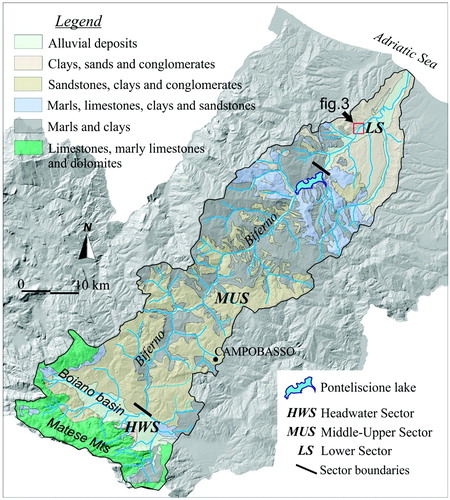
Along its length of ∼93 km towards the Adriatic Sea, the Biferno River cuts transversally the NE flank of the Apennine chain, crossing a sequence of folded and thrusting terrains of Tertiary age (Corrado, Di Bucci, Naso, & Butler, Citation1997; Patacca, Scandone, Bellatalla, Perilli, & Santini, Citation1992) as well as the minor uplifted and tectonically modified sedimentary successions of the last Apennine foredeep of Plio-Pleistocene age (Amorosi, Bracone, Di Donato, Rosskopf, & Aucelli, Citation2009; Bracone et al., Citation2012). Its catchment (drainage area 1316 km2) is strongly elongated in a SW-NE direction () and characterised by a dendritic drainage pattern.
From a physiographic perspective, the Biferno River catchment can be subdivided into three sectors: the headwater sector, the middle-upper sector and the lower sector, indicated as abbreviations HWS, UPS and LS, respectively, in and on the Biferno River longitudinal profile figure reported on the main map. Differences between these sectors concerning valley bottom and channel gradients are illustrated in the table included in the Biferno River longitudinal profile figure.
The headwater sector (HWS) coincides with the intra-montane tectonic Boiano basin () with the surrounding mountainous and hilly slopes predominantly composed of Limestones, marly limestones and dolomites and of Sandstones, clays and conglomerates, respectively (). The evolution of this sector was strongly determined by extensive tectonics which gave rise to the progressive subsidence of the Boiano basin as early as the Middle Pleistocene (Amato et al., Citation2010; Aucelli et al., Citation2011a) and its progressive filling with a lacustrine to fluvio-palustrine succession which terminates with fluvial gravels and sands (Alluvial deposits, ). This sector has not been included in the geomorphologic map because the Biferno River channel, though completely unconfined, lacks evidence of significant morphological changes during the time-period we investigated.
Immediately downstream of the Boiano basin, the Biferno River enters the middle-upper valley sector (UPS) which is characterised by a hilly to sub-mountainous landscape with maximum altitudes of ∼1300 m a.s.l. and etched into rocks of variable lithology, mainly Sandstones, clays and conglomerates, Marls, limestones, clays and sandstones and finally Clays and marls (). The latter unit is mainly composed of vari-coloured clays (Sannio Unit, Cesarano et al. Citation2011) which are particularly prone to landslides (Aucelli et al., Citation2001, Aucelli, Brancaccio, Ravera, & Rosskopf, Citation2004; Aucelli et al., Citation2010) and widespread in this area. The valley floor develops at elevations of 460 to 475 m a.s.l. and is made up of alternatively narrow and wide sub-reaches, reflecting variable conditions of resistance to bedrock erosion. The valley floor's end length of 7 km is submerged by the Ponteliscione artificial lake (see the Biferno River longitudinal profile figure on map), which was completed in the mid 1970s.
The lower sector (LS) is located between the Ponteliscione dam and the river mouth. Valley slopes in this area are predominantly composed of Clays, sands and conglomerates () which form the Plio-Pleistocene infill of the Southern Apennine foredeep (Amorosi et al., Citation2009). The valley floor progressively widens downstream from ∼500–700 m to ∼2 km with the Biferno River characterised by a sinuous to meandering/straight pattern.
The Biferno catchment is under the influence of a temperate-warm humid climate (Aucelli, Izzo, Mazzarella, & Rosskopf, Citation2007). Along a transect from the upper mountainous zone to the coastal zone, there is a marked decrease in precipitation and a progressive increase both in temperature and aridity. Consequently, while the headwater sector is characterised by a temperate-warm humid climate with hot summers lacking a dry season (Aucelli et al., Citation2007), the upper to lower valley sectors are characterised by very hot and dry summers. Because of such climate conditions, in particular the variable rainfall inputs, both in terms of annual totals and seasonal distribution, the Biferno River is characterised by a torrential regime with alternatively high and low discharges during autumn-winter and spring-summer, respectively.
3. Methods
The geomorphologic map focuses on fluvial processes and related landforms inferred on the basis of a multi-temporal analysis based on topographic maps, aerial photos and orthophotos covering the time-period 1869–2007, along with a data review from the literature and field surveys conducted in 2009 and 2010.
The multi-temporal analysis was performed in a geographic information system (GIS) environment using the ESRI's ArcGIS 9.3 and based on (1) large to medium-scale aerial photos from 1954, 1977 and 1992, (2) orthophotos from 2007, certified by the Molise regional authority, (3) 1:50,000 topographic maps of 1869 and 1907 (Italian Military Geographic Institute) and (4) the Carta Tecnica Regionale (CTR) 1:5,000 map sheet (edited by the Molise Region, 1992). Aerial photos from 1954 and 1977 were scanned at a resolution of 800 dpi and rectified adopting a number of control points selected from the CTR map of the Molise Region, also clearly visible on aerial photos (i.e. crossing, constructions, etc.). For each year assessed, a digital layer containing mapped landforms was set up. During digital mapping, two sources of potential errors were evaluated as originating from the rectification of aerial photos and editing itself (Comiti et al., Citation2011; Gurnell, Citation1997; Hughes, McDowell, & Marcus, Citation2006; Winterbottom, Citation2000). Firstly, the digitalization error (attributed to map scale and pixel dimensions of aerial photos) estimated at ∼2.5 m for the 1:5,000 scale map, 1.5 m and 0.6 m for aerial photos from 1954 and 1977, respectively. Secondly, the error related to the correction process, which originates from co-registration and rectification and corresponds, as for aerial photos of 1954 and 1977, to an RMSE declared value of ∼7.0 m and 5.0 m, respectively. Overlaying the single geomorphologic layers, it was possible to document the gradual evolution and related morphological changes which affected the valley floor from 1869 to 2007 and attribute relative age and chronological order to the mapped landforms.
For the final map, the mapped elements were transferred to a topographic map base derived from the 1:5,000-scale CTR sheets. To avoid confusion and enhance map readability, the topographic base was then reduced to selected elevation points. To illustrate relationships and interferences between valley bottom and slope features, up to 500 m large portions of the confining valley slopes were included in the map and differentiated in relation to (1) slope characteristics by means of contour lines spaced at 25-meter and (2) dynamics by mapping the outcropping slope deposits. The 25-meter contour lines were obtained using a 40 m resolution digital elevation model, edited by Molise Region.
The legend uses coloured symbols and surfaces to represent various group forms and related deposits, mostly following the mapping systems proposed by Brancaccio et al. (Citation1994) and Castiglioni et al. (Citation1999): forms of fluvial origin in green, slope forms in red, coastal and aeolian forms in blue and anthropogenic forms in black. Different shades of the same colour were used to distinguish forms of the same origin (e.g. fluvial terraces, shorelines) but of different age. In the case of channel relicts, age information was given by simply adding dates to the symbol. For those fluvial forms such as an active channel in 1954 and 2007, respectively, and channel relicts, colours other than green were used to highlight them.
To provide quantitative data on channel adjustments after 1954, a GIS-analysis was carried out by sub-dividing the Biferno channel in to stretches and calculating for each stretch the average channel narrowing (in percentage) and incision (in meters), reported on the main map. Comparing the 2007 average channel width of each stretch against that in 1954 (initial channel width), the amount of narrowing was determined in percentage and declared values were classified as per the given range: < 60%, 60% to 80%, > 80%. The average channel width was obtained by calculating, according to Surian et al. (Citation2008), the ratio between area/length of the channel stretch for each year considered. The bed incision rates were estimated by determining height differences of similar geomorphic surfaces of different age (such as those between floodplain areas active in 1954 and 2007, respectively) by means of topographic data extracted from maps and data acquired through global positional system measurements at field sites in 2009 and 2010. The amount of channel incision obtained was classified, according to Rinaldi (Citation2008), as: moderate (1–2 m), intense (2–4 m) very intense (> 4 m).
For final layout, the map was reduced to a scale of 1:20,000 and graphically sub-divided into four folios, representing four distinct reaches, as indicated by progressive numbers in the downstream direction. Reaches 1, 2 and 3 refer to the middle-upper sector of the Biferno valley (), whilst Reach 4 represents the valley floor sector located downstream of the Ponteliscione dam. Location and related boundaries of these reaches are shown on the Biferno catchment scheme and on the Biferno River longitudinal profile figures reported on the main map.
4. Geomorphologic features
The mapped landforms are aimed at providing a detailed framework on recent evolution and present-day dynamics of the Biferno River valley floor system. They include mainly fluvial, but also associated coastal, slope and anthropogenic forms, processes and deposits.
4.1 Fluvial landforms
The mapped fluvial landforms provide information on both the current morphologic setting and the dynamics and evolution of the Biferno River valley floor from 1869.
In particular, Fluvial terraces are present all along the studied valley floor. They are more widespread and better preserved in the lower reaches and highlight various phases of valley floor dissection. The multi-temporal analysis has led to the identification of four orders of fluvial terraces: the I-order terraces formed prior to 1869, the II-order terraces formed between 1869 and 1954, and the III-order and IV-order terraces formed during time-periods 1954–1977 and 1977–1992, respectively. The II, III and IV-order terrace remnants generally formed at the expense of the former alluvial valley floor and are so of alluvial origin.
Other important fluvial features are the mapped Alluvial fans, presently all dissected and lacking any evidence of recent dynamics. It is evident that their dissection accompanied channel incision and this dissection occurred in part prior to 1954, and also in part from 1954 to 1992 when the III- and IV-order terraces were formed.
A representative case of major channel adjustments which have characterised the Biferno valley floor from 1869 to 2007 is illustrated in which refers to a sub-reach ∼3 km in length located in the lower valley sector (for location refer to ). It demonstrates that the channel system has undergone a progressive and overall intense narrowing from 1954 and that this narrowing was accompanied by the formation of III and IV order terraces. It also demonstrates that I and II order terraces are generally of alluvial origin in the lower sector.
Figure 3. Major transformations of the Biferno River valley floor illustrated comparing fluvial forms characterising a small sub-reach located in Reach 4 (for location see also ) in 1954, 1977, 1992 and 2007, respectively.
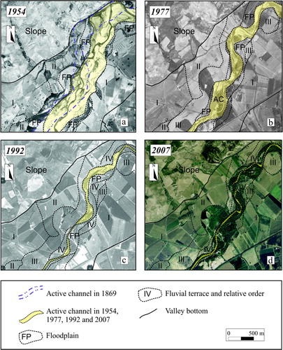
The map also includes quantitative data on Channel adjustments, i.e. channel narrowing and incision, which have affected the Biferno channel system from 1954 to 2007/2010 within the marked channel stretches (see Limit of channel stretch).
4.2 Coastal landforms and deposits
The mapped coastal landforms provide evidence of the coastal alluvial plain and coastline evolution in the Biferno mouth area since 1869. In particular, shorelines are mapped from 1869 to 2007 (see Shoreline and relative age). The most advanced shoreline dates to 1869 and 1907 when the Biferno mouth was characterised by a well-developed cuspate delta. Younger shorelines dating to 1954, 1992 and 2007, respectively, depict erosion of the delta and general progressive shoreline retreat up to 375 meters in to the Biferno mouth area (Aucelli et al., Citation2009b). This shoreline retreat occurred in unison with adjustments affecting the Biferno channel system and is most likely linked to an insufficient sediment delivery to the coast (Aucelli et al., 2009b).
4.3 Slope landforms and deposits
Within the upper and more or less confined fluvial reaches of the Biferno River, the narrow width of the valley bottom together with the weak nature of the confining slopes favour an intense interaction between fluvial and slope processes as evidenced by numerous landslide deposits descending the valley flanks and partially infilling the valley floor. Landslide deposits are frequently associated with fluvial erosion and, in particular, with current erosion dynamics (see Slope presently affected by fluvial erosion). They are either triggered by fluvial undercutting or they are responsible for the shifting of the active channel system to the opposite valley flank inducing its undercutting.
4.4 Anthropogenic landforms
The mapped anthropogenic landforms illustrate the main interventions on the river system, most of which were carried out in order to prevent flooding. Flood prevention interventions began in the early twentieth century when artificial levees were constructed within Reach 4 (Aucelli et al., Citation2009a). The completion of the Ponteliscione artificial lake in the mid 1970s, mainly aimed at hydro-electric and irrigation purposes, has significantly altered the natural flow regime by preventing particularly large flow and peak flow events thus contributing to flood prevention in Reach 4. A flood prevention effect is also attributed to the artificial Meander-cut off which was set up in the industrial zone in the 1970s.
As highlighted both by photo-interpretation and direct observations from field sites, the valley bottom is characterised by various zones which have been or are currently affected by mining of fluvial sands and pebbles (Mining area) which, locally, have significantly contributed to altering the original morphology of the valley floor.
5. Conclusions
The 1:20,000 scale geomorphologic map of the Biferno River valley floor, Molise Region, Southern Italy, has been illustrated. Fluvial landforms and related processes represent the main focus of this map. It illustrates recent and major transformations of the valley floor due to relevant channel adjustments (especially channel narrowing and incision) which have given rise to a differentiated and extensively terraced morphologic setting which characterises the current valley floor system. Within the lower reaches the interventions on the river system aimed at preventing fluvial erosion and flooding and the construction of the Ponteliscione dam, together have significantly contributed to alter the natural fluvial dynamics and to stabilize large portions of the valley floor.
The reconstructed valley floor transformations depict a sequence of stages which are in line with stages I–III of the channel evolution model for braided rivers proposed by Surian and Rinaldi (Citation2004), due to increasing channel narrowing and incision. They provide no evidence for Stage IV of the model characterised by channel widening, the significance of which is still an open question (Comiti et al., Citation2011).
The map includes numerous data on the relationships between recent and current fluvial dynamics and slope processes which can be used to create landslide, flood or erosion susceptibility maps, in order to support local land planning policies and sustainable land management. In particular, it is a valid supporting document for river restoration projects and environmental restoration as a whole. It also serves as a base for investigation of major land cover changes (e.g. Aucelli et al., Citation2011b). Finally, since the reconstructed evolution of the Biferno valley floor system is fairly representative of the fluvial systems of Central-Southern Italy, the data produced can be useful in developing potential scenarios of near-future dynamics of such fluvial systems.
Software
ESRI's ArcGIS 9.3 was used to create the geomorphologic layers to be superimposed and subject of analysis. Final map design was obtained using Corel Draw X5.
Supplemental Material
Download PDF (4.8 MB)Acknowledgements
The authors wish to thank reviewers for their helpful suggestions in particular C.P.J.M. van Elzakker for his cartographic review. Thanks also to Pietro Aucelli for his support in GIS analyses.
References
- Amato, V. , Aucelli, P. P.C. , Cesarano, M. , Pappone, G. , Petrosino, P. , Rosskopf, C. M. , and Russo Ermolli, E. , 2010. New chrono-stratigraphic data on the Boiano basin infilling (Molise, Italy) , Rendiconti Online Società Geologica Italiana 11 ((II)) (2010), pp. 616–617.
- Amorosi, A. , Bracone, V. , Di Donato, V. , Rosskopf, C. M. , and Aucelli, P. P.C. , 2009. The Plio-Pleistocene succession between Trigno and Fortore rivers (Molise and Apulia Apennines): stratigraphy and facies characteristics , Geoacta 8 (2009), pp. 35–46.
- Aucelli, P. P.C. , and Rosskopf, C. , 2000. Last Century valley floor modifications of the Trigno river (S. Italy): A preliminary report , Geografia Fisica e Dinamica Quaternaria 23 (2000), pp. 105–115.
- Aucelli, P. P.C. , Cinque, A. , and Rosskopf, C. , 2001. Geomorphologic map of the Trigno basin (Italy): Explanatory notes , Geografia Fisica e Dinamica Quaternaria 24 (2001), pp. 3–12.
- Aucelli, P. P.C. , Brancaccio, L. , Ravera, F. , and Rosskopf, C. M. , 2004. "Landslide susceptibility along the Adriatic flank of Southern Apennines (Italy): The case of Molise Region". In: Singh, In Savindea , Sharma, H. S. , and Kr De, Sunil , eds. Geomorphology and environment . Kolkata, India: ACB Publications; 2004. pp. 168–181.
- Aucelli, P. P.C. , Izzo, M. , Mazzarella, A. , and Rosskopf, C. M. , 2007. La classificazione climatica della regione Molise , Bollettino della Società Geografica Italiana, XII (2007), pp. 615–638.
- Aucelli, P. P.C. , Faillace, P. I. , and Rosskopf, C. M. , 2009a. Evoluzione geomorfologica del tratto finale del fondovalle del fiume Biferno (Molise) dal 1800 ad oggi , Bollettino della Società Geografica Italiana 87 (2) (2009a), pp. 367–378.
- Aucelli, P. P.C. , Iannantuono, E. , and Rosskopf, C. M. , 2009b. Evoluzione recente e rischio di erosione della Costa Molisana (Italia Meridionale) , Italian Journal of Geosciences 128 (2009b), pp. 759–771, doi:10.3301/IJG.2009.128.3.759.
- Aucelli, P. P.C. , Robustelli, G. , Rosskopf, C. M. , Scarciglia, F. , Di Paola, G. , and Lucà, F. , 2010. Geomorphologic map of the area between Frosolone and Trivento (Molise, Italy) , Journal of Maps 6 (1) (2010), pp. 423–434, doi:10.4113/JOM.2010.
- Aucelli, P. P.C. , Amato, V. , Cesarano, M. , Pappone, G. , Rosskopf, C. M. , Russo Ermolli, E. , and Scarciglia, F. , 2011a. New morphostratigraphic and chronological constraints for the Quaternary evolution of the Molise Apennine (southern Italy) , Geologica Carpathica 62 (1) (2011a), pp. 17–26, doi:10.2478/v10096-011-0002-2.
- Aucelli, P. P.C. , Fortini, P. , Rosskopf, C. M. , Scorpio, V. , and Viscosi, V. , 2011b. Recent channel adjustments and riparian vegetation response: Some examples from Molise (Italy) , Geografia Fisica e Dinamica Quaternaria 34 (2) (2011b), pp. 161–173, doi:10.4461/GFDQ.2011.34.15.
- Bracone, V. , Amorosi, A. , Aucelli, P. P.C. , Rosskopf, C. M. , Scarciglia, F. , Di Donato, V. , and Esposito, P. , 2012. The Pleistocene tectono-sedimentary evolution of the Apenninic foreland basin between Trigno and Fortore rivers (Southern Italy) through a sequence stratigraphic perspective , Basin Research 24 (2012), pp. 213–233, doi:10.1111/j.1365-2117.2011.00523.x.
- Brancaccio, L. , Castiglioni, G. B. , Chiarnini, E. , Cortemiglia, G. , D'Orefice, M. , Dramis, F. , and … Pellegrini, G. B. , 1994. Carta geomorfologica d'Italia - 1:50.000 , Guida al Rilevamento, Quaderni del Servizio Geologico Nazionale, serie III 4 (1994), pp. 1–42.
- Castiglioni, G. B. , Biancotti, A. , Bondesan, M. , Cortemiglia, G. , Elmi, C. , Favero, V. , and Tellini, C. , 1999. Geomorphological map of the Po Plain, Italy, at a scale of 1:250000 , Earth Surface Processes and Landforms 24 (1999), pp. 1115–1120, doi:10.1002/(SICI)1096-9837(199911)24:12<1115.
- Cesarano, M. , Pappone, G. , Amato, V. , Aucelli, P. P.C. , Baranello, S. , Casella, A. , and … Rosskopf, C. M. , 2011. Stratigrafia ed assetto geometrico dell'unità del Sannio nel settore settentrionale dei monti del Matese , Rendiconti Online Società Geologica Italiana (2011), pp. 35–38.
- Comiti, F. , Da Canal, M. , Surian, N. , Mao, L. , Picco, L. , and Lenzi, M. A. , 2011. Channel adjustments and vegetation cover dynamics in a large gravel bed river over the last 200 years , Geomorphology 125 (2011), pp. 147–159.
- Corrado, S. , Di Bucci, D. , Naso, G. , and Butler, R. W. , 1997. Thrusting and strike-slip tectonics in the Alto Molise region (Italy): Implication to the neogene-quaternary evolution of the Central Apennines Orogenic System , Journal of Geological Society of London 154 (1997), pp. 679–688.
- Gurnell, A. M. , 1997. Channel changes of the river Dee meanders, 1946–1992, from the analysis of air photographs , Regulated Rivers: Research and Management 13 (1997), pp. 13–26.
- Hughes, M. L. , McDowell, P. F. , and Marcus, W. A. , 2006. Accuracy assessment of georectified aerial photographs: Implications for measuring lateral channel movement in a GIS , Geomorphology 74 (2006), pp. 1–16.
- Keesstra, S. D. , Van Huissteden, J. , Vandenberghe, J. , Van Dam, O. , De Gier, J. , and Pleizier, I. D. , 2005. Evolution of the morphology of the river Dragonja (SW Slovenia) due to landuse changes , Geomorphology 69 (2005), pp. 191–207.
- Kondolf, G. M. , Piégay, H. , and Landon, N. , 2007. Changes in the riparian zone of the lower Eygues River, France, since 1830 , Landscape Ecology 22 (2007), pp. 367–384.
- Liébault, F. , and Piégay, H. , 2002. Causes of 20th century channel narrowing in mountain and piedmont rivers of southeastern France , Earth Surface Processes and Landforms 27 (2002), pp. 425–444.
- Marston, R. A. , Girel, J. , Pautou, G. , Piegay, H. , Bravard, J. , and Arneson, C. , 1995. Channel metamorphosis, floodplain disturbance, and vegetation development: Ain River, France , Geomorphology 13 (1995), pp. 121–131.
- Patacca, E. , Scandone, P. , Bellatalla, M. , Perilli, N. , and Santini, U. , 1992. La zona di giunzione tra l'arco appenninico settentrionale e l'arco appenninico meridionale nell'Abruzzo e nel Molise , Studi Geologici Camerti, Vol. Spec. (1991/2), CROP 11 (1992), pp. 417–441.
- Rinaldi, M. , 2008. Schede di rilevamento geomorfologico di alvei fluviali , Italian Journal of Quaternary Sciences 21 (1B) (2008), pp. 353–366.
- Rovira, A. , Batalla, R. J. , and Sala, M. , 2005. Response of a river sediment budget after historical gravel mining (the lower Tordera, NE Spain) , River Research and Applications 21 (2005), pp. 829–847.
- Surian, N. , and Rinaldi, M. , 2003. Morphological response to river engineering and management in alluvial channel in Italy , Geomorphology 50 (2003), pp. 307–326.
- Surian, N. , and Rinaldi, M. , 2004. "Channel adjustments in response to human alteration of sediment fluxes: Examples from Italian rivers". In: Golosov, V. , Belyaev, V. , and Walling, D. E. , eds. Sediment transfer through the Fluvial System, Publication 288 . 2004. pp. 276–282, IAHS.
- Surian, N. , and Rinaldi, M. , 2008. Variazioni morfologiche degli alvei fluviali in Italia: stato dell'arte e prospettive , Italian Journal of Quaternary Sciences 21 (1B) (2008), pp. 233–240.
- Surian, N. , Ziliani, L. , Cibien, L. , Cisotto, A. , and Baruffi, F. , 2008. Variazioni morfologiche degli alvei dei principali corsi d'acqua veneto friulani negli ultimi 200 anni , Journal of Quaternary Sciences 21 (1B) (2008), pp. 279–290.
- Surian, N. , Rinaldi, M. , Pellegrini, L. , Audisio, C. , Maraga, F. , Teruggi, L. , and … Ziliani, L. , 2009. "Channel adjustments in northern and central Italy over the last 200 years". In: James, L. A. , Rathburn, S. L. , Whittecar, G. R. , and Management and restoration of fluvial systems with broad historical changes and human impacts, , eds. Geological Society of America Special Papers, 451 . 2009. pp. 83–95, doi:10.1130/2009.2451(05).
- Winterbottom, S. J. , 2000. Medium and short-term channel plan form changes on the Rivers Tay and Tummel, Scotland , Geomorphology 34 (2000), pp. 195–208.
- Wyzga, B. , 2008. "A review on channel incision in the Polish Carpathian rivers during the 20th century". In: Habersack, H. M. , Piégay, H. , and Rinaldi, M. , eds. Gravel-bed rivers VI: From processes understanding to river restoration. Developments in earth surface processes, 11 . Amsterdam, The Netherlands: Elsevier; 2008. pp. 525–555.