
Abstract
This paper compares the emergence of urban regions around European second-tier cities based on population data between 1890 and 2011. It asks whether a characteristic trajectory of formation exists for those urban regions distinguishing them from the centrifugal growth typical of the early expansion stages of larger cities. The results are consistent with existing research and contribute to a spatial-historical characterisation of second-tier urban region formation. Their dominant long-term urbanisation mode lies somewhere between centrifugal and polycentric models of development, suggesting a more nuanced interpretation of urbanisation timelines and stressing the legacy of past urban growth in current urbanisation dynamics.
1. Introduction
A growing body of research, building upon a renewed interest in second-tier cities in Europe, has been offering contributions about their specific spatial, socio-economic and cultural characteristics (Hodos Citation2011; OECD Citation2012; ESPON Citation2012; Cardoso and Meijers Citation2016). Second-tier cities are defined here simply as non-capital, medium-sized cities, which do not play dominant roles in their countries but are economically, culturally and demographically significant (ESPON Citation2012). Researchers have established relations of similarity between different cases and defined features that help categorise such cities. However, relatively few studies have expanded their analysis to the urban region scale and even fewer have used a historical perspective to understand the long-term trajectories of spatial formation of second-tier urban regions. The question whether they follow particular and broadly similar processes of urbanisation remains unanswered.
Nevertheless, some directions are provided by earlier research. Although urban growth in general has become more polycentric, dispersed and fragmented in the last 50 years, longer term perspectives recognise essential differences in the way urban regions start taking shape. The literature about urban spatial structures refers to contrasts between centralised and hierarchic versus fragmented and networked models (Heynen, Loeckx, and Smets Citation1991; Anas, Arnott, and Small Citation1998; Hohenberg Citation2004; Schneider and Woodcock Citation2008), stressing the many ways to build polycentric urban regions (PURs). An important contribution, adding greater precision to these distinctions, is Champion’s classification of ‘centrifugal’, ‘fusion’ and ‘incorporation’ modes (Citation2001). The first two modes are associated, respectively, with the dominant outward expansion mode of large conurbations, like Paris or Madrid, and with the merger of smaller centres into PURs (Parr Citation2004). The third is an ‘in-between’, non-hierarchical mode, mixing the outward expansion of a leading core with the semi-autonomous growth of other nearby centres, all eventually densifying into a single urban region.
Associating such dominant forms of development with specific types of city distinguishes, respectively, ‘first-order’ cities (often large capitals), which have played a historically dominant role in their urban region, decentralising activity from the core to the periphery and projecting their expansion agenda over a relatively passive hinterland; and, on the opposite end, PURs, consisting of similarly sized, proximate and connected urban centres, with no primate city. But somewhere in between lie the medium-sized, second-tier cities, equally embedded in large urban regions of which they are the main centres (unlike PURs), but lacking the size and power to redistribute functions and activities throughout the territory, override local spatial configurations and define large-scale hierarchies like their first-order counterparts. This further distinction raises the question whether urban regions formed around such second-tier cities also tend to be closer to a particular development mode.
Indeed, while their spatial structure will vary according to local demographic regimes, administrative divisions and the legacy of past urban growth, many such cities do not seem to comply with the centrifugal, core-to-periphery model associated with the dominant forms of early expansion of the largest cities. This can underlie the findings by Cardoso and Meijers (Citation2016) about the more polycentric distribution of urban functions in second-tier urban regions, compared to first-tier urban regions. It also follows the arguments by Hohenberg (Citation2004) about the ‘central place’ mode of growth of large capitals versus the ‘networked’ mode of smaller cities, as well as the distinction by Heynen, Loeckx, and Smets (Citation1991) between hierarchic ‘spiderweb’ structures around dominant core cities and ‘networked’ metropolises elsewhere.
However, these cities equally depart from PUR models, as they may be the leading – though not the dominant – cities in the urban region. Therefore, an intermediate model, such as Champion’s ‘incorporation mode’ (Citation2001), may be appropriate to describe the typical mode of formation of many second-tier urban regions. The aim of this paper is to explore whether it is possible to identify such specific trajectories by exploring commonalities and differences in a set of second-tier urban regions representing different socio-economic and historical contexts in Europe: Porto (Portugal), Antwerp (Belgium) and Bristol (the United Kingdom).
This is important for a variety of reasons: first, finding patterns in different cases may add important elements to the growing scholarship about ‘second-tier cities’ as a specific research and policy concern (Hodos Citation2011; ESPON Citation2012; Parkinson, Meegan, and Karecha Citation2015; Cardoso and Meijers Citation2016). Second, except for strictly PUR cases, non-centrifugal forms of urbanisation have been mostly attributed to the second half of the twentieth century, seen as regime changes following earlier stages of centrifugal growth (van den Berg, Drewett, and Klaasen Citation1982; Schmid Citation2006). Champion’s triple classification has been used in research but often to argue that cities have progressed in time along centrifugal, incorporation and fusion modes (Solis, Mohino, and Urena Citation2015). But some urban regions have experienced early forms of multi-centric and non-hierarchical growth, gradually populating the territory with semi-autonomous urban fragments, without going through earlier core-periphery expansion stages (Portas, Domingues, and Cabral Citation2007).
Finding evidence of these processes helps us reconsider assumptions about the emergence of ‘edge cities’, or similarly recent phenomena, as if ‘appearing from nowhere’ (Batty Citation2001), or whether to qualify specific locations in urban regions as ‘suburbs’ or as much older and complex urban fragments. Applying this perspective to the case of second-tier cities also suggests other questions, such as whether they have a weaker impact than larger cities on the urbanisation of their hinterlands, and thereby more traces of early urban morphologies could be kept, or whether the suggested dominant development mode is typical of a specific subset of second-tier urban regions. All of this will be included in the discussion section.
The paper will analyse the progression of urbanisation in three cases, based on population data between 1890 and 2011, relying on the relation between population change and urbanisation proposed in literature (Batty Citation2001; Turok and Mikhnenko Citation2007). Although population data do not capture many dimensions of urban change, such as land use and flows, restricting the scope of the analysis, it is one of the few indicators available for such a long timeframe. The judgements will be based on empirical criteria such as the persistence of the settlement structure (rank-size based), the mapping of population density changes, the parallel growth trends of core cities, agglomerations and remote areas in the urban region, and the growth rates of individual places as a function of distance to the core. The results are likely to be different from what we would observe in an overwhelmingly centrifugal or polycentric process.
The next section will argue the importance of the historical dimension in analysing urbanisation and discuss why research has generally disregarded that aspect. This is followed by a description of the methodology used, including data sets, indicators and criteria of distinction. The results are then presented for three case studies and their implications are discussed. Finally, some conclusions are offered about the features of second-tier urban regions, their historical similarities and future directions of research.
2. The different routes towards urban regions
[The South West region] is full of rivers and towns and infinitely populous […] interspersed with a great number of villages, I had almost said innumerable villages, hamlets and scattered houses […]. (Daniel Defoe, cited in Barry, Citation2000, 81)
The province [northwest Portugal] […] has no more than three cities and twenty-five towns; however, the villages and hamlets are so numerous, that it looks like a continuous city. (Silveira Citation[1789] 1990)
The long-term spatial processes shaping urban regions left behind physical, cultural and infrastructural traces over which contemporary forms are imprinted (Batty Citation2001), and a diachronic analysis of urbanisation trajectories can offer insights that a snapshot of current configurations does not provide (Lambregts Citation2006). Yet, that historical dimension is not always recognised by comparative studies. One of the outcomes of this neglect is an adherence by policymakers to generic normative concepts applied to urban regions as a ‘remedy for all kinds of urban and regional problems’ (121). This disregards that experiences of development have historical and local explanations and may be exemplary only for specific types of urban region, which changed over time in different ways, often shifting trajectories and blending different forms of growth (Solis, Mohino, and Urena Citation2015).
To understand the reasons behind this neglect, it is useful to retrace the assumptions of existing theories. A growing set of literature emerged in recent decades describing the end of cities as bounded and discernible entities and the generalisation of undirected, fragmented and dispersed urbanisation processes of territorial scale, shifting the matter of concern of urban studies from the ‘city’ to the city-region, city-territory, urban field, and other neologisms defining the new entities taking shape (Gottmann Citation1961; Friedmann and Miller Citation1965; Soja Citation2000; Schmid Citation2006; Brenner Citation2014). This stage of extensive urbanisation, overriding the urban–rural divide and coalescing their meanings into a ‘new kind of space’ (Piorr, Ravetz, and Tosics Citation2011, 10), is broadly associated to the second half of the twentieth century. However, much older descriptions by observers of populous ‘continuous cities’ made of ‘innumerable villages and hamlets’ (see the quotes earlier) remind us that urban areas which ‘appear from nowhere’ (Batty Citation2001, 636) are rare. While the scale and scope of urbanisation has changed in the last 50 years, in many cases the seeds of the current fragmented urbanisation processes, creating places and landmarks and overriding clear boundaries, were sown earlier than much urban literature assumes.
The further we go back in time, the more difficult it becomes to tell the story of territories outside core cities. Data are scarce, mapping and imagery are inaccurate, and the history of their urbanisation falls outside the proper history of urbanism (Grosjean Citation2010). Such territories were not, until recently, seen as an urban studies’ problem. Urbanisation outside core cities lacked proper planning and consequently an interpretative framework as a (proto-)urban setting. Mapping such places was more the concern of military authorities than urban scholars. Only in the twentieth century has the problem of urbanisation been applied to the territory as a whole, which led to assumptions that extensive urbanisation is recent only because it appeared recently in research contexts (Grosjean Citation2010). This perpetuated the dominant representation of urban growth as a city expanding over an assumed and unproblematic spatial-historical void, gradually filled by ‘suburbs’, equally devalued as a historical and unproblematic, something lesser than ‘the city’ (Phelps et al. Citation2006). Brenner has called this approach ‘methodological cityism’ (Brenner Citation2014, 15), a tendency to focus on cities and their outward expansion, disregarding the remaining territory.
Largely ignoring the role of places outside core cities as something more than empty spaces awaiting urban expansion, core-periphery models become the default trajectory of urban growth. In fact, urban regions outside strict PUR cases are often treated as the outcome of the diffusion and relocation of core city activity, ‘a long process of very extended decentralisation from big central cities to adjacent smaller ones, old and new’ (Hall and Pain Citation2006, 3). But a centrifugal expansion process from a monocentric into a polycentric configuration is not the only possible route to an urban region, as Champion’s model (Citation2001), discussed earlier, shows.
In that model, the centrifugal mode roughly expresses the progressive outward expansion of large cities over a comparatively ‘empty’ hinterland, arguably the initial form of expansion of large, dominant cities (see Mogridge and Parr Citation1997, for an account of centrifugal expansion as the dominant growth mode in London until the mid-twentieth century (Solís, Ureña, and Ruiz-Apilánez Citation2012, for the case of Madrid). These authors describe a succession of stages towards more polycentric forms of growth but rely on an initial monocentric and centrifugal configuration. However, historical–geographical research (Hohenberg and Lees Citation1995; Hohenberg Citation2004) and studies about the spatial structure of contemporary urban regions (Burger et al. Citation2011; Cardoso and Meijers Citation2016) suggest that different origins led to different outcomes.
This makes the historical analysis of urban region formation relevant for planners today: Champion offers some corollaries to his classification, writing how urban centres emerging from different modes of growth build different socio-economic and functional configurations, and can thereby explore different paths to economic development. This has clear implications for policy and spatial planning, which many scholars have stressed (Lambregts Citation2006; Burger et al. Citation2011; Harrison and Heley Citation2015). Notably, centrifugal and hierarchic forms of expansion from dominant core cities onto hinterlands with little history of prior urbanisation are likely to produce different functional and socio-economic arrangements, as well as political and cultural relations, than a mix of fragmented growth processes, emanating from a main core and other centres, with greater local divergences and coexisting contradictory trends. Despite the mixed patterns over time that characterise most cases, the analysis that follows tries to test the hypothesis, as far as population change is a good indicator, that non-dominant second-tier cities formed urban regions more according to the latter model.
3. Methodology
To achieve these purposes, a diachronic analysis of long-term urbanisation patterns based on population change (1890–2011) in three European second-tier urban regions will be used. A view covering such a long period confronts the notion that dispersed, undirected and fragmented urban expansion is a ‘recent’ phenomenon, highlighting place-specific processes that were influencing urbanisation before the discipline of urban studies started to look outside core cities.
3.1. Data and indicators
The historical study of urban regions has embedded difficulties of precision and data availability. The problem is how to observe large urban regions with the same level of precision as core cities, with data that can be compared for different cases. Indicators normally used in comparisons of urban development, like land use changes or extension of built up fabric, only exist with sufficient accuracy since the 1950s (EEA Citation2002; Kasanko et al. Citation2006). However, population data go much further back to the time when national authorities started systematically gathering census data.
Using population to understand urban change has advantages and limitations. While absolute numbers say little about the problem, population change is both an influence in and consequence of urban conditions: ‘Migration is a response to differences in employment or the quality of life between places, even if the process of adjustment is inefficient.’ (Turok and Mikhnenko Citation2007, 167). Batty (Citation2001) uses the location and change of population settlements to argue the continuity and persistence of European urban systems. Population change can be used as a proxy to map the spatial progression of urbanisation, allowing direct and accessible comparisons between different contexts. The main problem is the arbitrary definition of spatial units (administrative areas), which can be mitigated by focusing on the smallest possible unit (LAU2): extreme variability of unit size and inaccuracies from density and settlement pattern variations within large units are thus kept under control. Naturally, more precise units used in current measurements, such as 1 km2 grids, are also unavailable for a long-term analysis.
3.2. Case studies
The case studies emerged from the list of 126 second-tier cities recently produced by ESPON (Citation2012). The cities of Porto, Antwerp and Bristol were chosen according to two criteria related to the preliminary discussion:
They should be second-tier cities, that is, not political capitals or the largest national cities, preferably in countries where the contrast with a dominant capital is visible from significant political, economic or functional imbalances. The ESPON report on second-tier cities (Citation2012) clearly situates the three cases in this context.
They should be embedded in larger urban regions, being their main core but not functionally and demographically hegemonic – that is, neither dominant core cities nor part of a ‘polycentric urban region’. Porto and Antwerp have been similarly described as part of an extensive ‘diffuse city’ (De Meulder et al. Citation1999; Portas, Domingues, and Cabral Citation2007); Bristol is the UK city-region where the shift to polycentricity has been stronger in recent years (Burger et al. Citation2011).
While other cases would qualify, the final selection contributes to bridge the gap between northern and southern Europe in comparative research. Moreover, there are historical similarities between the three cities – their role as outward-looking port cities and the early forms of (proto-)industrialisation in their hinterlands – which provide additional themes for discussion, as Section 5 will show.
3.3. Study area
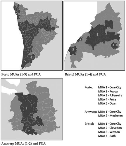
The study area is defined following the ESPON 1.4.3 report (Citation2007) that determines functional urban regions (FUAs) and morphological urban regions (MUAs). The ESPON definition was chosen due to the access to population data at LAU2 level, kindly sent by the IGEAT team at Université Libre de Bruxelles, and the fact that it considers the existence of several MUAs (morphological agglomerations) in any given FUA, unlike other definitions (see the 2012 EU-OECD definition), which make a distinction between a main core and the periphery. Highlighting the presence of multiple MUAs rather than only the dominant one is closer to the theoretical arguments of this paper. The urban regions are depicted in . Their basic data appear in .
Table 1. Description of urban regions (ESPON Citation2007) and number/average area of LAU2 units in the analysis.
Figure 1. Porto, Bristol and Antwerp urban regions, as defined by ESPON (Citation2007). Dark colour: morphological urban regions (MUAs); light colour: functional urban region (FUA).
While LAU2 units in Porto and Antwerp have remained rather stable throughout the years, the successive administrative boundary changes in the UK make the Bristol case less reliable. Nevertheless, an effort was made to access historical data for each parish/ward/local government district and to attribute the most extreme population changes to boundary changes rather than explosive urban growth. Therefore, a few values for Bristol are estimates: when the LAU2-equivalent data were inaccessible for a given area, the averages of the higher boundary were used.
Five census years with approximately 30-year intervals are used from 1890 to 2011. Data were gathered from a variety of publicly available sources: for Porto, all census documents are available online from the National Statistics Institute. Data exist at the lowest sub-municipal division (freguesia) for the whole study period. For Bristol, data at ward level for 2011 are available from the Office for National Statistics, while the 1981 data were accessed through NOMIS, the official labour market database (small area statistics); older data were mainly gathered from the ‘A Vision of Britain’ database, run by the University of Portsmouth. For Antwerp, data exist only at the municipality level and were gathered as published online by municipalities and other sources, remitting to the National Census data owned by StatBel, the Belgian Statistics Institute.
The analysis follows four steps, based on the following indicators and empirical distinctions, applied to the five study periods:
A rank-size distribution of population by LAU2 unit, to assess the permanence or change of the settlement pattern in each urban region by evaluating changes in the shape of the distributions. For example, a shift from a centrifugal to a polycentric regime at a given time would reveal more contrasting distributions, with formerly low-ranked places suddenly springing up, while more similar curves suggest greater stability of the settlement structure (Batty Citation2001).
Population density change by LAU2 unit, allowing the detection of population growth ‘hotspots’ according to their location in the urban region. A centrifugal expansion mode would show early phenomena of gradual density change – suburbanisation – at increasing distances from the core, while other modes provide a more complex picture of densification across the region with no obvious core-periphery structure.
Population growth by geographical area (core city, MUA, FUA), checking the coexistence, succession and interaction between core expansion, urban fringe growth and peri-urban densification. Again, a centrifugal mode would reveal interrelated trends of decline and growth in different places (e.g. core city vs. surrounding agglomeration; see Mogridge and Parr Citation1997, 102), while in an incorporation mode, growth in the core agglomeration or in more remote parts of the region does not necessarily correspond, respectively, to core city decline or dispersion of suburbs to the peri-urban scale.
Population density change as a function of distance to core city (according to geographical area, and comparing the 1890–1950 and 1950–2011 periods), assessing how the distance to the core city influenced the pace of urbanisation elsewhere, whether specific areas followed independent agendas and how this changed over time. Here, a centrifugal mode would show a strong influence of the core, although diminished over time, while other forms of growth may reveal early manifestations of multi-centric urbanisation.
4. Results
4.1. The early seeds of the urban region
This step of the analysis plots the log distribution of population and rank of LAU2 units in descending order for the five study periods (see ). Unlike the assessment of the relative size of individual cities usually obtained by rank-size relations, here the units considered are not distinct cities but subdivisions covering the totality of each urban region, providing an overview of the settlement pattern across the territory. So, what matters for the results is not whether the distribution follows Zipf’s law (Gabaix Citation1999), because we are not comparing the fortunes of individual, competitive, cities, but how much the shape of the distribution has changed over time (see Batty Citation2001, for a similar approach).
The results confront the notion of a dominant city expanding over a void and reveal that the seeds of the present dispersed and polycentric patterns were to a degree visible in earlier periods. In Porto and Antwerp, the general population increase does not mask the fact that the settlement structure has remained relatively stable, with places largely keeping their ranks and growing in some consonance (except for a ‘bumpier’ 2011 curve in Antwerp). No settlements sprung up, marking a regime shift, and urbanisation advanced through the continuous densification of existing morphologies across the region. In Antwerp, we can also observe the curve getting increasingly flatter, suggesting that less-populated areas have grown quicker than the largest settlements, reducing the contrasts between degrees of urbanisation and leading to a convergence of regional densities as argued by Soja (Citation2011), although the process seems more ingrained in existing structures than in Soja’s view of a radical regime transition.
The curve shapes in Bristol reveal more oscillations, especially since 1950, indicating that some places sprung up at certain points in time following stronger mode changes. The curves are also steeper than in Porto and Antwerp, revealing greater differences between more- and less-urbanised places. While the different sizes of LAU2 units in this case may hide some internal variation in the larger units, affecting the shape of the curves, there is less evidence than in the other cases of a smooth densification of existing structures, which can partially be explained by the stronger role of planning regulations regarding urban containment, adopted earlier than in Portugal or Belgium.
4.2. Mapping population density change
When both core cities and ‘hinterlands’ are analysed with similar accuracy, metropolitan growth departs from the dominant laboratorial view of progressive spatial expansion along a linear timeline. )–() depicts this multi-centricity and fragmentation by showing, based on population change, where and when urban growth occurred in the region.
Figure 2. Rank-size population distribution per LAU2 unit in Porto, Antwerp and Bristol, 1890–2011.
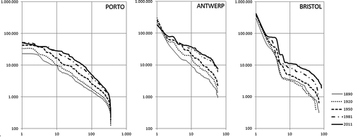
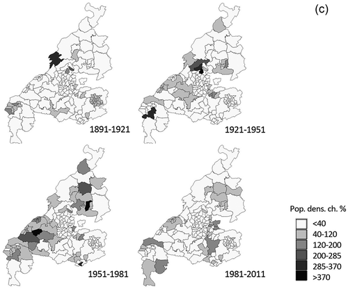
Figure 3. (a) Population density variation per LAU2 unit in Porto 1890–2011; (b) population density variation as per LAU2 unit in Antwerp 1890–2011; (c) population density variation as per LAU2 unit in Bristol 1890–2011.
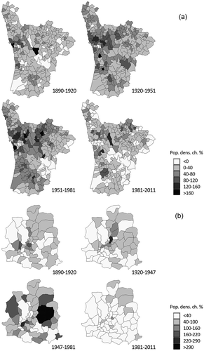
Figure 3. (Continued).
) shows an initial period of similar density increase all over the Porto region, followed by stronger growth north of the core city between 1920 and 1951. Small growth areas had begun to appear in more remote areas, mainly due to the development of local industry. This fragmented pattern is not restricted to the impact of centrifugal core city expansion. 1951–1981 marked the strongest increase virtually everywhere in the region (except for the core city), especially in the Porto MUA, stressing the emergence of the smaller urban centres that build the core agglomeration, as well as the densification of the FUA outside predefined centres. The core MUA gradually integrated with other MUAs, and a continuous pattern of similarly high growth rates can be read across a wide area.
In Antwerp, high densification of isolated patches is an even stronger trend, mostly visible in the east of the urban region, where several fragments, both in the core MUA and the FUA, were experiencing early growth. 1947–1981 corresponds to a strong population increase everywhere, with many municipalities more than doubling their population, both in the core city periphery and further away in the FUA, suggesting a relative autonomy from core city influence. No special growth was detected in the south, closer to Brussels; the greatest change tends to be in the eastern fringe. Since 1981, growth rates have decreased substantially.
Some of the older data for individual LAU2 units in Bristol are unreliable, and, by resorting to the values of higher-level units, the indications of similar growth in large parts of the urban region can be deceiving. In any case, we can observe that generalised population density increases at the significant levels found in Porto and Antwerp came later to Bristol, and even then only affected some parts of the urban region. Between 1891 and 1921, that increase occurred mainly around established secondary centres. 1921–1951 marked a higher growth tendency in connective areas outside the main centres, namely north and south of the core city. This trend continued in the next period, with a more fragmented pattern of densification expanding further north and south. The more remote areas in the region enjoyed highest growth in recent times, but the general pace has decreased everywhere.
4.3. Population growth by geographical area
Models based on successive stages of sub-, de- and re-urbanisation (van den Berg, Drewett, and Klaasen Citation1982) assume that different growth modes dominate in different periods and that they are sequential, in the sense that a metropolitan area will achieve a certain state – for example, dispersion – by having experienced all prior phenomena – for example, suburbanisation. This obscures simultaneity and contradictory trends that have been part of urban region formation for a long time. Locating indicators of such trends is the purpose of this section, by comparing population change according to geographical location ().
Figure 4. Population change in Porto, Antwerp and Bristol, 1890–2011 according to geographical areas (core city, remaining core MUA, other MUAs, remaining FUA).
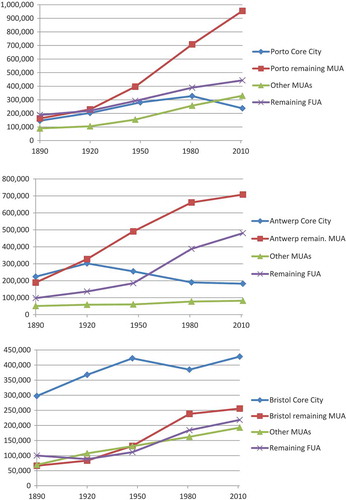
Porto is characterised by an early balanced distribution of population between core city, agglomeration and FUA (which was basically a densely occupied ‘rural’ typology). The core city was not very significant mainly because it was administratively bounded; but even considering the surrounding agglomeration (Porto MUA), there was no clear demographic dominance and many people lived in the remaining FUA. From 1920, the core MUA started to grow more, but that did not correspond to the emptying out of other MUAs or the FUA, whose growth rate was unaffected. The population loss in the core city since 1981 is also insufficient to justify the growth of other areas, suggesting a mix of core agglomeration expansion and general densification of dispersed settlements, with different parts of the region following largely autonomous dynamics.
The city of Antwerp was the main demographic core until 1950, but a tendency for population loss started from 1920. Note that, to avoid inconsistencies, the values refer to the city’s original nine districts, which are measured independently, and do not consider the annexation of several municipalities in 1983. While all other areas experienced some growth, the strongest trend has been the great population increase in the lower-density FUA, which lacks dense morphological cores but now concentrates one-third of the total population. Considering the early distribution of dense areas visible above and the location of the fastest growing municipalities, this suggests a strong densification of a pre-existing dispersed pattern.
In Bristol, the core city remained the largest population centre throughout the whole study period. The population density of the city of Bristol increased strongly until 1951 then suffered a gradual loss and has been growing again recently. The remaining core MUA was comparatively unimportant until 1951 but then experienced strong growth at the same time that the core city was losing population. Unlike the more mixed growth processes in Porto and Antwerp, this correlation may be considered as closer to a classic suburbanisation process. Other MUAs and the remaining FUA also increased their pace in the post-1950 period, but not at the rates of the other two case studies. The core-periphery hierarchy has been less affected.
4.4. Proximity to core city and population density change
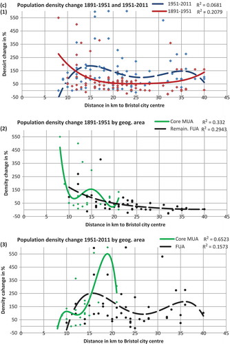
The last indicator analyses whether being geographically close to the core city had an impact on the population density variation of individual LAU2 areas, by depicting their growth rate as a function of distance to the core city. The graphs evaluate this from two perspectives: the general trend of the urban region for 1890–1950 and 1950–2011, and the trends of individual areas within the urban region (FUA and MUAs) for the same two periods ()–(c)). Note that in Porto only two secondary MUAs have a sufficient number of LAU2 units with data for all periods to produce a relevant trend line. Secondary MUAs in Bristol and Antwerp lack these features and are therefore not individualised. Despite the generally low R2 values, the figures provide some interesting indications.
Figure 5. (a) Population density variation as a function of distance to the core city in Porto: (1) for the whole urban region, 1890–1951/1951–2011; (2, 3) by geographical area (FUA/MUAs). (b) Population density variation as a function of distance to the core city in Antwerp: (1) for the whole urban region, 1890–1951/1951–2011; (2, 3) by geographical area (FUA/MUAs). (c) Population density variation as a function of distance to the core city in Bristol: (1) for the whole urban region, 1890–1951/1951–2011; (2, 3) by geographical area (FUA/MUAs).
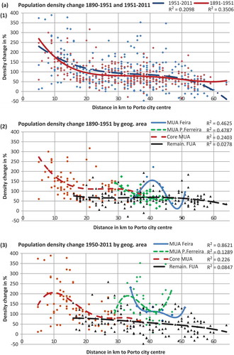
Figure 5. (Continued).
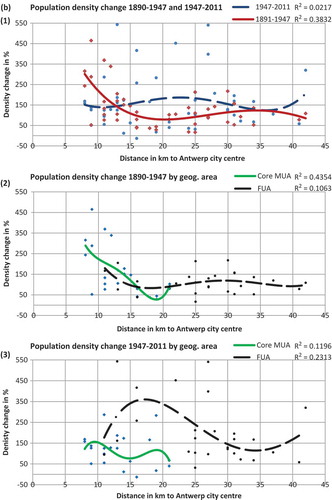
Figure 5. (Continued).
In Porto, the influence of core city proximity was similar in 1890–1951 and 1951–2011. Both regression lines fall as distance increases with no major peaks affecting that trend. The next two graphs illustrate the trends in individual geographical areas. Here, we can see how the pattern of the core MUA changed over time, peaking in 1951–2011 further away from the core city than in 1890–1951 (around 10 km distance). The FUA areas show relatively stable values regardless of distance to the core, except for the truly remote areas. However, the other two MUAs considered – both quite industrialised – reveal an independent agenda throughout the whole study period, and their regression lines cannot be linked to the dominant influence of Porto. They were constrained by their own sub-centres, suggesting greater polycentricity, but in a less hierarchical form.
The influence of proximity to Antwerp in the density increase of the urban region changed significantly from 1890–1947 to 1947–2011. The first period shows the impact of the core city, possibly due to the development of the Port of Antwerp. The second period illustrates the role of economic diversification and relocation throughout the region, and the proximity to the core city no longer corresponds to stronger population density change. The same pattern is visible if we distinguish the Antwerp MUA and the surrounding FUA – the MUA is strongly influenced by core city proximity in 1890–1947 and not particularly in 1947–2011, while the FUA timidly follows a similar pattern in the former period but mostly detaches from it in the latter, peaking at around 18 km and rising again in the most distant areas, probably influenced by the juxtaposition of relations with Brussels (south), Ghent (west) and the Netherlands (north-east).
In Bristol, many equally distant LAU2 units show disparate values. This is in part due to the administrative boundary changes in the UK affecting the stability of LAU2 units, but also to the relatively compact growth of urban centres – unlike Porto and Antwerp, it is possible for an individual unit to increase 500% while the next unit shows no growth. Between 1891 and 1951, population density increased closer to the core city and around 40 km distance, arguably reflecting the influence of Bath. This was inverted in the 1951–2011 period, with lower growth rates in the areas closer to Bristol and increase around the 15 km distance. This is clearer in the division by geographical areas: the 1951–2011 trend in the core MUA shows greater density increase as the distance to the core city grows, illustrating the ‘leapfrogging’ of development over the Green Belt adopted in the late 1950s, and the rapid growth of commuter towns like Yate. The FUA curve peaks around the 15 km and rises again in more distant areas, stressing the importance of alternative centres outside the core MUA.
5. Discussion and interpretation
Despite the neglect of the role of places outside core cities in regional urbanisation, there is more to say about their history than merely seeing them as empty space awaiting expansion. ‘Non-city’ territories were part of early extensive urbanisation processes, often following an autonomous agenda invisible to urban studies concentrated on core cities and centrifugal expansion: in Belgium, ‘late nineteenth-century urban dispersal was indeed much more about autonomous urbanisation within the countryside than about the suburban expansion of established cities’ (Fisher Citation2013, 334). In fact, even before the period analysed here, this was already clear to some observers, as noted in the descriptions of north-west Portugal as a ‘continuous city’ or of the Bristol region punctuated by ‘innumerable villages’. Barry adds that the south-west is not usually associated with the sudden urban growth of the main centres in the nineteenth century, like the Midlands, ‘in part because of the strong urban infrastructure already in place, with over a quarter of the region’s people living in towns by 1660’ (Citation2000, 67).
These insights question the generic models that often underpin research on urbanisation and address the recent concerns of Brenner (Citation2014) or Harrison and Heley (Citation2015) about the city-centric bias of city-regional research and policy. As the role of places outside core cities in the development of current configurations is recognised, core-periphery and spatially selective perspectives are replaced by the consideration of the full scale of the urban. In this sense, an interpretative lens that recognises the urban region as an ‘extensive city’ with urban qualities and problems, supports integration strategies at that scale, and sees planning as a tool to ensure liveability at any point of the territory rather than in predefined centres, including the interstitial spaces between ‘proper’ cities, seems appropriate to deal with this urban form.
Alongside these general arguments, we can now summarise the results and implications of the analysis and explore some further hypotheses it suggests about the historical factors contributing to this type of urbanisation trajectories.
5.1. Summarising the results
The strongest feature of the Porto region is the largely autonomous development process of its different sub-regions, more erratic and fragmented than Antwerp, which converged quicker into density homogeneity. The core city lacked a strong influence over the region, which underwent forms of dispersion and peri-urbanisation without prior periods of centrifugal expansion and suburbanisation. The findings illustrate this: early patterns of polycentric and generalised urbanisation; simultaneous and continuous population growth in MUAs and FUA regardless of the dynamics in the core(s); densification of isolated patches across the region with no indication of a centrifugal process (even the core MUA growth emerges from the multi-centred dynamics of nine municipalities); and some influence of core city proximity in peripheral growth, but with strongly independent trends in sub-regions around smaller centres.
In Antwerp, the decline of the core city came with a strong densification of the core MUA but even more of the FUA. While this could be expected for the former, as a consequence of centrifugal expansion and relocation of population, the FUA is more remote and lacks important morphological cores. The urbanisation of Antwerp has also been more about the densification of an existing dispersed structure than expansion of established centres, ‘to a large extent a parasite of the pre-existing network of rural roads which undergoes no restructuring during urbanisation.’ (De Meulder Citation2008, 28) An early and dense coverage of public transport, small cadastral divisions and a multitude of municipalitiesFootnote1 – the latter two aspects similar to Porto – also played a role. The attraction of the core city was initially significant, but the simultaneous growth in several places stresses the role of alternative, even if incipient, urban areas, which gradually gained importance, as suggested by the changing impact of core city proximity in population change.
Porto and Antwerp have been embedded very early in a spatially extensive process of dispersed growth that led to a ubiquitous urbanised landscape, rather than a system of discrete urban cores. Bristol was from the beginning a more polycentric region, in the sense that there were several discernible centres, but their individual growth patterns remained more compact until recently. This supports Barry’s (Citation2000) description of the region since the seventeenth century as consisting of numerous small towns rather than concentrated in a single core city, this latter aspect being similar to Porto and Antwerp. But Bristol is the only case where the core had a higher population share throughout the whole study period, even if sometimes losing people. That loss has been consistent in time and scale with the growth of the immediate MUA – thus closer to a classic ‘edge-of-city’ expansion model – mainly due to the economic success of the north fringe after the 1970s (Boddy et al. Citation2004). Unlike the apparent ‘naturalness’ of dispersion and densification dynamics in the other cases, based on factors intrinsic to the territory, growth in Bristol was more directed and supported by investment and infrastructure.
5.2. ‘The land is a palimpsest’
The relevance for spatial planners of a long-term analysis of the urban region hinges on the fact that new and old forms and scales of urbanisation often coexist. This is a general feature of the European urban system (Batty Citation2001). The land is a palimpsest (Corboz Citation1983), and the problems faced by planners dealing with current urban forms relate to where such forms come from and what was there before. There are differences between intensive expansion processes, spreading outward through large patches of suburban growth, functional nodes and massive infrastructure, overriding older, local morphologies, and trajectories in which the core has less power and mass, and by consequence less impact on the development of the urban region. In the latter type, the ancient occupation of the territory was often consolidated, rather than erased, throughout the years and left behind a porous mesh of spatial fragments and networks providing support for contemporary urban growth (Portas, Domingues, and Cabral Citation2007).
Planning strategies in these territories must address, for instance, the dissociation between large-scale infrastructural networks (hierarchical and focused on discrete centres) and existing morphologies (isotropic and extensive, a continuous capillary fabric rather than a sequence of nodes). In Antwerp, the lack of such knowledge was criticised by De Meulder et al. (Citation1999), seeing the 1997 Regional Master Plan for Flanders as an unfit model borrowed from Dutch experiences, imposing a ‘compact city’ policy on a ‘totally contrary’ (Citation1999, 80) spatial structure. In Porto, Domingues (Citation2008) has stressed the dead ends encountered by generic policy aims, such as urban containment, when applied to the urbanisation patterns of the region.
5.3. Looking for traces of early urbanisation in second-tier urban regions?
Contextualising planning strategies is perhaps more necessary in places where spatial homogenisation forces played a weaker role and place-specific contexts retained their importance. Processes like the ones explored here leave behind loose spatial traces of early urbanisation (roads, buildings, infrastructure, land divisions) which were often countered, and sometimes obliterated, by large-scale suburbanisation and contemporary development dynamics. However, the extent to which these traces could be overridden, and how much they have disappeared, is related to the scale and intensity of expansion of the largest centres and their influence on the development of the surrounding urban region. In other words, and while the analysis cannot be conclusive in this respect, it is likely that the different routes towards urban regions theorised by Champion (Citation2001) had variable impacts on these fragile forms of urbanisation, changing their role in contemporary configurations.
Indeed, a commonly argued feature of ‘first-order’ cities is their historically dominant role over the hinterland, characterised by core-dependent, intensive and progressive spatial expansion processes, that only cities large enough to first attract or aggregate a large amount of functions, people and activity were later able to trigger. Such cities could influence accordingly the functional and spatial configuration of the urban region, forming hierarchic links with smaller centres (Barry Citation2000; Phelps et al. Citation2006). This process, closer to Champion’s centrifugal mode, relies on deep spatial changes – suburbanisation of territorial scale, major infrastructural interventions, so on – and is likely to erase existing and smaller-scale forms of urbanisation in the surroundings.
Conversely, in cities lacking the attractive pull to gather and redistribute functions and activities, as well as the ability to determine functional and spatial hierarchies, such processes may have constrained less the formation of the urban region, whose growth is likely to remain more multi-centric and undirected. Unlike primate cities, core city expansion in this case did not have the reach and strength to erase historical peculiarities and place-specific configurations. These may therefore have been retained for longer, giving them a bigger role in subsequent transformations.
An example is Porto, whose trajectory has been related to two phenomena denoting fundamental differences between that city and a large, dominant capital: first, unlike Lisbon, that concentrated political and economic power and high-end functions in the core while squeezing vast swaths of housing and lower-order activities to the periphery (Domingues Citation2009), Porto lacked the role of the state and economic headquarters as producers of centrality to produce similar core-periphery contrasts. Second, the settlement patterns in the region were based on small cadastral divisions, a ‘rhizomatic’ collection of roads and paths connecting dispersed housing and activities (Portas, Domingues, and Cabral Citation2007), and a network of centres supporting a mix of rural lifestyles and small-scale industrialisation, which were unaffected by the spatial expansion or the economic demands of the core city. There was a progressive densification of urbanisation but no functional clustering, therefore little incentive for new functions, infrastructures or intensive spatial interventions on the territory.
5.4. The explanation of proto-industrialisation
Similar descriptions have been associated to regions experiencing early (proto-)industrialisation. These regions were characterised by a dispersed network of small industrial units inserted into rural typologies that did not tend to cluster into large complexes or promote the emergence of important functional and demographic cores. Proto-industrialisation adapted to existing cadastral and topographic constraints, and, as long as there was sufficient population density, could recruit the workforce from people living nearby who would literally walk to work,Footnote2 with no need for major infrastructural or functional changes to existing settlements. As argued by Mendels for eighteenth-century Flanders, ‘industrial growth was induced and promoted by population growth. […] The highest levels of rural industrialization […] were found in areas with the highest population density and land fragmentation’ (Citation1971, 269). Proto-industrialisation also developed early in south-west England, mainly in the form of heterogeneous and deconcentrated units of cloth industry, ‘each with specific urban networks’ (Barry, Citation2000, 81), and north-west Portugal, where ‘diffuse industrialisation’ was characteristic of regions with high population density but low rates of urbanisation (Santos Citation1992).
This insight – population without urbanisation – suggests a hypothetical relation between core city typologies and the structure of industrialisation in their hinterland. This paper does not go as far back as the emergence of proto-industrialisation, nor does it cover its multiple explanations. However, Barry (Citation2000) argues that one of the reasons why the city of Bristol did not grow as much as its northern rivals is that it did not forge hierarchic ties with its industrial hinterland, consolidating fragmented nodes and promoting (through political power and economic policy) the emergence of denser and larger complexes in the region. Instead, the city left the development of the emerging textile industry to its own devices and focused on its main economic priority of being a colonial port city. There was a functional differentiation and little contact between the workforce in Bristol and the workforce spread across the region.
Therefore, it is interesting to note that Porto and Antwerp were also port cities, relying on related mercantile activities, and have equally failed to consolidate dense industrial nodes in their surroundings. Arguably, this can be a case of need and ability to do so. Cities less concerned with an outward-looking economy and more dedicated to exploit the emergent economies of its own hinterland would forge stronger ties with that region, promote its agglomeration economies by upscaling industrial concentration, gradually insert infrastructural and functional changes in pre-existing settlements, attempt to control decision-making and ultimately build a more hierarchic political, functional and socio-economic structure at the urban region scale. This process is likely to be mirrored by an intensive mode of expansion, more destructive of pre-existing structures, but needs a core city which is large, politically powerful and gathers a dominant part of the region’s economic activity. This was not the case of our three case studies. Hence the view by Barry, following his argument about the detachment between Bristol and its industrial hinterland, is that, despite population growth, there was little sign of ‘a growing Bristol [demographic] domination of the region’ (Barry, Citation2000, 79).
This is strikingly similar to the description of ‘dominant’ primate cities as opposed to ‘weaker’ second-tier cities discussed earlier, namely concerning their need and ability to constrain the economic, spatial and functional development of the urban region. The question whether outward-looking, mercantile medium-sized cities are less concerned with and less able to urbanise and control their surroundings, and also tend to be those whose spatial patterns were less affected by large-scale consolidation of industry and therefore the traces of early urbanisation are more visible, provides another path for further research on comparative urban history.
6. Conclusions
This paper addressed the historical trajectory of urbanisation in three European second-tier urban regions. It looked for insights about the sequence and coexistence of different modes of urban expansion and evaluated the role of core cities and other centres in the process. By doing that, the analysis confronts the dominant core-periphery view of cities ‘decentralising’ into urban regions and proposes to situate their development somewhere between the centrifugal expansion mode typical of primate cities and the fusion mode of PURs.
The results help sustain the claim that the routes to urban region formation show simultaneous and contradictory features of expansion, dispersion and densification. Bristol evolved from a progressive expansion of multiple urban nodes, large and small, while Porto and Antwerp followed a more isotropic process of dispersion and densification often detached from existing cores. In all cases, place-specific factors influenced development modes, which did not follow a clear sequence or chronology. Dispersed, fragmented and undirected dynamics are in many ways intrinsic to ancient territorial conditions, rather than based on recent changes such as suburban lifestyles or the advent of the private car. Strong and continuous core city dominance, either by exerting centripetal and centrifugal forces or influencing the pace of growth in their proximity, could not be detected.
Overall, and despite their differences, this situates the long-term development form of the three cases closer to Champion’s incorporation mode (Citation2001) than to the other two modes. Of course, the limitations of the approach must be mentioned. The association to the incorporation mode is made only as much as population change reflects trajectories of urbanisation, based on the results mentioned earlier and on what we would arguably observe if a dominantly centrifugal or fully polycentric process had been the case. Nothing is said about Champion’s further insights about the different economic and functional relations between centres and their potential socio-economic fortunes, which other research can address. However, the analysis has shown that Porto, Bristol and Antwerp are neither monocentric cities scattering ‘suburbs’ over a previously unoccupied territory nor the outcome of similar centres gradually fusing through individual expansion and infrastructural linkages. They are the cores of complex and fragmented regions of generalised urbanisation, generating both secondary centres and scattered areas lacking a morphological core, well before becoming an urban region.
Future research can explore whether this type of processes are particularly common around second-tier cities. In fact, while the findings do not claim generalisability, the common features of the case studies stand in opposition to the core-periphery contrasts assumed as the ‘original state’ of many hegemonic, primate cities. Cities lacking this ‘capital effect’ (i.e. the historical role of the state and the economy as producers of functional centrality) have arguably failed to counteract the tendency for dispersion, fragmentation and autonomy of urbanisation in their hinterland. Population and activities have not so much ‘decentralised’ but densified and clustered across the urban region. This is consistent with the findings by Cardoso and Meijers (Citation2016) about the spatial distribution of urban functions in first- and second-tier cities in Europe, and, together with the literature discussed earlier, suggests correlations between the functional, demographic and morphological configurations of urban regions.
While these arguments and the existing literature seem to suggest so, future research can verify whether capital cities would present contrasting results strictly under the same methodology to those obtained by the second tiers. But the discussion section opens up other hypotheses: it may be that these are not qualities of second-tier urban regions per se, but rather emergent features of the type of relations that outward-looking, medium-sized port cities develop with their industrialising hinterlands. Or they may be characteristic features of regions experiencing early processes of dispersed industrialisation. Comparative work in other second-tier urban regions in different conditions may shed some light over these questions.
Acknowledgement
The author wishes to thank Fundação para a Ciência e a Tecnologia (FCT) for the financial support of this research (grant SFRH/BD/80157/2011).
Disclosure statement
No potential conflict of interest was reported by the author.
Additional information
Funding
Notes
1. See Harrison and Heley (Citation2015) about how the ‘non-city’ spaces in an urban region actually gather not only population but also an important part of the region’s decision-making powers and therefore need to be considered when envisioning a governance framework for the urban region. In Belgium and Portugal, all municipalities have formally the same powers over their territory, regardless of their size or urban–rural typology.
2. This also relates to the fact that population dispersal throughout the nineteenth century is only partially explained by the effects of the extension of railway. Although a correlation between increasing population densities and the extension of rail (more based on number and proximity of stations than length of lines) has been detected, for example, for England and Wales (Felis-Rota, Henneberg, and Mojica Citation2011), in some cases, like north-west Portugal, the railway would often follow previous demographic dispersal rather than the other way round.
References
- Anas, A., R. Arnott, and K. A. Small. 1998. “Urban Spatial Structure.” Journal of Economic Literature 36: 1426–1464.
- Barry, J. 2000. “South-West.” In The Cambridge Urban History of Britain – Volume II 1540-1840, edited by P. Clark, 67–92. Cambridge: Cambridge University Press.
- Batty, M. 2001. “Polynucleated Urban Landscapes.” Urban Studies 38 (4): 635–655. doi:10.1080/00420980120035268.
- Boddy, M., K. Bassett, S. French, R. Griffiths, C. Lambert, A. Leyshon, I. Smith, M. Stewart, and N. Thrift. 2004. “Competitiveness and Cohesion in a Prosperous City-Region: The Case of Bristol.” In City Matters, edited by M. Boddy and M. Parkinson, 51–70. Bristol: Policy Press.
- Brenner, N. 2014. Implosions/Explosions: Towards a Study of Planetary Urbanization. Berlin: Jovis Verlag.
- Burger, M., B. de Goei, L. Van der Laan, and F. J. M. Huisman. 2011. “Heterogeneous Development of Metropolitan Spatial Structure: Evidence from Commuting Patterns in English and Welsh City-Regions.” Cities 28 (2): 160–170. doi:10.1016/j.cities.2010.11.006.
- Cardoso, R., and E. Meijers. 2016. “Contrasts between First-tier and Second-tier Cities in Europe: A Functional Perspective.” European Planning Studies 24 (5): 996–1015. doi:10.1080/09654313.2015.1120708.
- Champion, A. G. 2001. “A Changing Demographic Regime and Evolving Polycentric Urban Regions: Consequences for the Size, Composition and Distribution of City Populations.” Urban Studies 38 (4): 657–677. doi:10.1080/00420980120035277.
- Corboz, A. 1983. “The Land as Palimpsest.” Diogenes 31 (121): 12–34. doi:10.1177/039219218303112102.
- De Meulder, B., J. Schreurs, A. Cock, and B. Notteboom. 1999. “Patching Up the Belgian Urban Landscape.” Oase 52: 78–113.
- De Meulder, B. 2008. “Old Dispersions and Scenes for the Production of Public Space.” In Architectural Design: Cities of Dispersal, edited by R. Segal and E. Verbakel. New York: Wiley.
- Domingues, A. 2008. “Urbanização Extensiva – uma nova escala para o planeamento.” CITTA 1st Annual Conference on Planning Research, Porto, May.
- Domingues, A. 2009. “Como tornar Lisboa uma cidade amigavel, segura e inclusiva para todos?” Keynote address to ‘Seminarios da Carta Estrategica’, Lisbon.
- EEA (European Environment Agency). 2002. Towards an Urban Atlas: Assessment of Spatial Data in 25 European Cities and Urban Areas. Copenhagen: EEA.
- ESPON. 2007. 1.4.3 - Study on Urban Functions. Final Report. Brussels: ESPON and IGEAT.
- ESPON. 2012. SGPTD - Second Tier Cities in Territorial Development in Europe: Performance, Policies and Prospects. Final Report. Liverpool: ESPON and European Institute of Urban Affairs.
- Felis-Rota, M., J. Henneberg, and L. Mojica. 2011. “A GIS Analysis of the Evolution of the Railway Network and Population Densities in England and Wales 1851-2000.” Economic History Society Annual Conference; 2011 April 1-3; Cambridge.
- Fisher, A. 2013. “Urbanisation sans urbanisme. Une histoire de la ‘ville diffuse” (Book Review). Planning Perspectives 28 (2): 333–335. doi:10.1080/02665433.2013.774564.
- Friedmann, J., and J. Miller. 1965. “The Urban Field.” Journal of the American Institute of Planners 31 (4): 312–320. doi:10.1080/01944366508978185.
- Gabaix, X. 1999. “Zipf’s Law for Cities: An Explanation.” The Quarterly Journal of Economics 114 (3): 739–767. doi:10.1162/003355399556133.
- Gottmann, J. 1961. Megalopolis: The Urbanized Northern Seaboard of the United States. New York: The Twentieth Century Fund.
- Grosjean, B. 2010. Urbanisation sans Urbanisme: une histoire de la ‘ville diffuse’. Wavre: Madraga.
- Hall, P., and K. Pain. 2006. The Polycentric Metropolis: Learning from Mega-City Regions in Europe. London: Earthscan.
- Harrison, J., and J. Heley. 2015. “Governing beyond the Metropolis: Placing the Rural in City Region Development.” Urban Studies 52 (6): 1113–1133. doi:10.1177/0042098014532853.
- Heynen, H., A. Loeckx, and M. Smets. 1991. “La péripherie: Reconnaissance d'une problématique.„ In Environnement Urbain- contribuitions d'experts, edited by Commission des Communautés européennes,19–29. Luxembourg: Office des publications officielles des Communautés européennes.
- Hodos, J. 2011. Second Cities: Globalisation and Local Politics in Manchester and Philadelphia. Philadelphia: Temple University Press.
- Hohenberg, P. 2004. “The Historical Geography of European Cities: An Interpretive Essay.” In Handbook of Regional and Urban Economics, edited by J. Henderson and J. Thisse, Vol. 4, 3021–3052. Amsterdam: Elsevier.
- Hohenberg, P. M., and L. H. Lees. 1995. The Making of Urban Europe, 1000-1994. Cambridge: Harvard University Press.
- Kasanko, M., J. Barredo, C. Lavalle, N. McCormick, L. Demicheli, V. Sagris, and A. Brezger. 2006. “Are European Cities Becoming Dispersed? A Comparative Analysis of 15 European Urban Areas.” Landscape and Urban Planning 77 (1–2): 111–130. doi:10.1016/j.landurbplan.2005.02.003.
- Lambregts, B. 2006. “Polycentrism: Boon or Barrier to Metropolitan Competitiveness? The Case of the Randstad Holland.” Built Environment 32 (2): 114–123. doi:10.2148/benv.32.2.114.
- Mendels, F. 1971. “Industrialization and Population Pressure in Eighteenth-Century Flanders.” The Journal of Economic History 31 (1): 269–271. doi:10.1017/S0022050700111428.
- Mogridge, M. 1997. “Metropolis Or Region: On The Development And Structure Of London.” Regional Studies 31 (2): 97–115. doi:10.1080/00343409750133233.
- OECD. 2012. Redefining “Urban”. A New Way to Measure Metropolitan Areas. Paris: OECD.
- Parkinson, M., R. Meegan, and J. Karecha. 2015. “City Size and Economic Performance: Is Bigger Better, Small More Beautiful or Middling Marvellous?” European Planning Studies 23 (6): 1054–1068. doi:10.1080/09654313.2014.904998.
- Parr, J. 2004. “The Polycentric Urban Region: A Closer Inspection.” Regional Studies 38 (3): 231–240. doi:10.1080/003434042000211114.
- Phelps, N., N. Parsons, D. Ballas, and A. Dowling. 2006. Post-Suburban Europe: Planning and Politics at the Margins of Europe’s Capital Cities. Basingstoke: Palgrave Macmillan.
- Piorr, A., J. Ravetz, and I. Tosics. 2011. Peri-Urbanisation in Europe: Towards a European Policy to Sustain Urban-Rural Futures. Copenhagen: University of Copenhagen/Academic Books Life Sciences.
- Portas, N., A. Domingues, and J. Cabral. 2007. Políticas Urbanas: Tendências, estratégias e oportunidades. Lisbon: Fundação Calouste Gulbenkian.
- Santos, M. 1992. “Processos de industrialização difusa: breves notas.” Sociologia 2: 121–144.
- Schmid, C. 2006. “Networks, Borders, Differences: Towards a Theory of the Urban.” In Switzerland: An Urban Portrait, edited by R. Diener. Basel: Birkhäuser.
- Schneider, A., and C. Woodcock. 2008. “Compact, Dispersed, Fragmented, Extensive? A Comparison of Urban Growth in Twenty-Five Global Cities Using Remotely Sensed Data, Pattern Metrics and Census Information.” Urban Studies 45 (3): 659–692. doi:10.1177/0042098007087340.
- Silveira, A. [1789] 1990. “Racional Discurso sobre a Agricultura e População da Provincia de Alentejo.” In Memórias Económicas da Academia Real das Ciências de Lisboa 1789-1815, edited by M. Nunes and J. L. Cardoso, 43–98. Lisboa: Banco de Portugal.
- Soja, E. 2000. Postmetropolis: Critical Studies of Cities and Regions. Oxford: Blackwell.
- Soja, E. 2011. “Regional Urbanization and the End of the Metropolis Era.” In The New Blackwell Companion to the City, edited by G. Bridge and S. Watson, 679–689. Oxford: Blackwell.
- Solis, E., I. Mohino, and J. Urena. 2015. “Global Metropolitan-Regional Scale in Evolution: Metropolitan Intermediary Cities and Metropolitan Cities.” European Planning Studies 23 (3): 568–596. doi:10.1080/09654313.2013.878691.
- Solís, E., J. Ureña, and B. Ruiz-Apilánez. 2012. “Transformación del Sistema Urbano-Territorial en la Región Central de la España Peninsular.” Scripta Nova, Revista Electrónica de Geografía y Ciencias Sociales 16: 420.
- Turok, I., and V. Mikhnenko. 2007. “The Trajectories of European Cities 1960-2005.” Cities 24 (3): 165–182. doi:10.1016/j.cities.2007.01.007.
- van den Berg, L., R. Drewett, and L. Klaasen. 1982. Urban Europe: A Study of Growth and Decline. Vol. 1. Oxford: Pergamon Press.