Abstract
The Digital Earth concept as originally proposed by former US Vice president Al Gore is now well established and widely adopted internationally. Similarly, many researchers world-wide are studying the causes, effects and impacts of Global Change. The authors commence by describing a five-step approach to the development of Digital Earth technologies. This is followed by a detailed account of Digital Earth research and developments in China. The authors then present the research results of Global Change studies carried out in China, based on the Digital Earth approach. These research results are based on a classification of global change regions. This covers the following global change situations:
Forest and grassland fires in Northern China, temperate region desertification and dust storms, underground coal fires, deforestation and carbon sequestration, protection and utilisation of wetlands, Avian Influenza and the spread of diseases, Tibet Plateau uplift and sub-tropical monsoon climate region, and sea-level rise. The research results show that the environment does not behave in a way easily understood by the traditional disciplinary approach. Although man is clearly a contributing factor to certain Global Change aspects, such as underground coal fires, desertification, land use changes etc., many of the aspects of Global Change are naturally occurring phenomena which have been changing over centuries, and will continue to do so, no matter what actions we undertake to reverse these processes. Hence, in their conclusions, the authors propose that the communities involved in Digital Earth modelling and in Global Change research co-operate closer to overcome the limitations inherent in the current ‘conventional’ scientific approach, where scientists have very much stayed within their respective scientific boundaries. Such an integrated approach will enable us to build the next level of scientific infrastructure required to understand and predict naturally occurring environmental changes, as well as that of coupled human–environmental systems.
Introduction
The Digital Earth concept as proposed by Al Gore (Citation1998) is well described, in terms of its early history, development, and societal impacts in other papers in this journal, (e.g. Foresman Citation2008, Goodchild Citation2008 and Ehlers Citation2008), and hence will not be repeated here. Similarly, global change research has benefited greatly over the past decades from simulations with quite advanced climate models, which are largely based on the analysis of meteorological and other earth observation satellite and in-situ data (Stern Citation2006).
However, global change involves significantly more components than only climate. Changes in the Earth System, which refer to the suite of interacting physical, chemical, biological and human processes, can have significant consequences, without involving any major changes in climate (Steffen and Tyson Citation2001).
In this paper, the authors first describe a five-step approach to the development of Digital Earth technologies. This is followed by an account of the Chinese situation with regards to Digital Earth research and development. The authors then present a number of examples of global change research, based on the Digital Earth approach. These cover forest and grassland fires, desertification and sandstorms, deforestation, forest carbon sequestration, wetlands conservation, monitoring migratory birds for the spread of avian influenza (bird flu), Tibet Plateau uplift, sea level rise, and underground coal fires. The research results presented are based on a classification of Global Change regions in China developed by the authors and presented for the first time in this paper. Although the research results described in this paper relate mainly to China, the approach may also be applicable and relevant to other regions of the globe.
At the end of the paper, the authors draw some conclusions on the role that Digital Earth can play and contribute to global change studies at global, regional and local levels.
Developments in the science and technology of Digital Earth
The Digital Earth concept was the inevitable outcome of the space era. Ever since the first images of our planet Earth became available, earth observation has contributed greatly to the development of the information society. The 21st century is characterised by regular global coverage by data from geostationary satellites, detailed environmental information from polar orbiting satellites at a variety of spatial, spectral, and temporal resolutions, highly advanced computer, multi-media and virtual reality technology, as well as stable global positioning systems. In addition, geographic information systems, and broadband network communication technology enable highly accurate three-dimensional (3D) models, integration of multi-source, multi-resolution, multi-temporal global earth observation data sets to be produced. These, together with socio-economic spatial statistical data enable decision makers to use these technologies to benefit mankind (Fischer-Kowalski and Haberl Citation2007).
In concrete terms, Digital Earth can be considered in terms of the following five phases:
-
Data extraction;
-
Information extraction;
-
Knowledge extraction;
-
Modelling;
-
Decision making.
Data extraction
The first step is to extract the relevant data from the earth observation imagery. The relevant satellite sensor parameters, after radiometric, geometric and standardisation procedures have been applied, need to be extracted from the numerous satellite systems providing data on a daily basis. They then have to be transmitted, stored in large data bases, to enable data query and exploitation services. The imagery and the metadata associated with it, form the input for the next phase, namely the extraction of meaningful (useful) information.
Information extraction
Extracting relevant information from these huge data archives and data bases involves a number of technologies which are all undergoing rapid advancement. These include geo-statistical analysis, object-oriented image classification, graphical information analysis, data mining and especially the study of dynamic global change studies using change detection technologies. This implies that the data sets used are fully calibrated in step 1 above, so that quantitative comparisons of different regions of the globe can be compared.
Knowledge extraction
The third phase involves extracting ‘knowledge’ or real understanding of the information extracted from the earth observation data. Here various kinds of professional application models are applied to the imagery, data and information in order to extract some objective ‘laws’ which provide the scientific basis for engineering design, quality/reliability standards or for management information systems.
Modelling
Based on these objective laws and some reference boundary conditions, it is possible, by means of virtual reality modelling, to reconstruct past and present natural and social processes/situations, and then to predict future development trends for global change researchers, and thus to provide them with alternative scenarios (van Genderen Citation1999).
Decision making
The final steps in this process is to present the outputs of the models to the decision makers (e.g. on impacts of sea-level rise, deforestation, desertification, etc.) to enable them to select the best of the multiple options available from the models, most suited to their practical, political, geographical, socio-economic conditions.
From the above process, it can be seen that by promoting the Digital Earth strategy in relation to global change issues, we can contribute to the advancement of science and technology, sharing of information resources, and to improving global socio-economic and environmental development.
This concept is treated in depth by Fischer-Kowalski and Haberl (Citation2007), who argue that by concentrating on the biophysical dimensions of change, across multiple scales, social development issues can be explicitly linked to changes in the natural environment.
Digital Earth in China
Background
The central government and the community of science and technology in China have paid great attention to the development of Digital Earth. Since the emergence of the concept of Digital Earth in 1998, several workshops on Digital Earth have been held in China. At the first International Symposium on Digital Earth in Beijing in 1999, the Beijing Declaration on Digital Earth was approved (Ehlers Citation2008). An International Steering Committee of the Symposium was formed in 2000, and this was subsequently transformed into the International Society for Digital Earth in 2006, with its Headquarters in Beijing.
In 1999, scientists in China submitted a proposal on China's Digital Earth Development Strategy to the State Council. A Coordinating Committee of National Geographical Spatial Information was formed with participants from 11 ministries in 2000. This resulted in many initiatives by various agencies in the field of Digital Earth. Some of the main ones included the following:
-
A research team for ‘Constructing the Geographical Information Frame Overall Strategy for Digital China’ was formed in 2001 by the State Bureau of Surveying and Mapping.
-
In the same year, the Ministry of Construction published a ‘Technical Guideline of Demonstrative Application Engineering for Urban Information Based Technology’ and ‘Several Suggestions on Speeding up the Process of System Information’.
-
The Ministry of Land Resources set up the target of constructing a National Land Resources Information System.
-
The Chinese Academy of Sciences initiated several knowledge innovation projects of ‘Research on Digital Earth Basic Theory’ and ‘Digital Earth Prototype System’, and setup a new organisation called Centre for Earth Observation and Digital Earth (CEODE) in 2007.
-
Beijing University has established an Institute of Digital China.
-
The Ministry of Construction has organised several ‘China International Conference on Digital City’ and ‘China International Expo on City Construction Technology and Equipment’ in 2001 2006 and 2007, with the objective of discussing and promoting the applications of the Digital Earth concept for China's cities.
-
In June 2007, the 303rd Xiangshan Science Forum, a high level forum on scientific viewpoints, was held in Beijing. The themes of the forum included (1) Scientific meaning of Digital China and its developing strategy; (2) the technical system and innovation of Digital China, (3) the engineering strategy and industrial promotion; (4) the action plan for Digital China.
Currently, 20 provinces and autonomous regions are building digital provinces, and some 200 cities have initiated their programmes of digital city, and more than 100 cities have successfully built ‘Digital City’. For example, ‘Digital Fujian’ has integrated over 80 databases from 21 bureaus or departments, and provided consultative service to provincial, regional, and municipal governments. The Dongcheng District in Beijing has built up a large scale ‘grid network of 10 000 m’ information management system, and proposed a brand new version for city management. Some large cities, such as Beijing have built up digital areas and digital communities, for example, ‘Digital Zhongguancun’, ‘Digital Wangfujing’. In addition, for comprehensive treatment and management of major rivers, ‘Digital Yangtze River’, ‘Digital Yellow River’, and ‘Digital Hai River’ have also been initiated. All of them provide information services for coordinating resource exploitation and environment protection, and also for supplying information for regional sustainable development. (Chen and Guo Citation2000).
The following sections describe earth observation and geospatial data infrastructure in building Digital Earth, the Digital Earth Prototype System (DEPS) developed at the Chinese Academy of Sciences, and the application of DEPS in the 2008 Beijing Olympics.
Earth observation and geospatial data infrastructure
‘Digital Earth’ is an information integrative engineering system built upon global earth observing systems, satellite communication systems, the global internet and other cutting edge technologies of the 1990s. The vigorous development of Earth observation technology is an indispensable basis for Digital Earth. Chen and Guo (Citation2000) provide a more detailed discussion on the relation of Digital Earth and Earth observation.
Over the past 30 years, since the first launch of a Chinese satellite China has launched over 50 satellites and 6 Shenzhou spacecraft. Six satellite series are currently operational. These are:
-
Recoverable remote sensing;
-
‘Dongfanghong’ communication and broadcasting satellites;
-
‘Fengyun’ meteorological satellites;
-
‘Shijian’ scientific probing and technological experimental satellites;
-
‘Resources’ earth observing satellites;
-
‘Beidou’ navigation and positioning satellites.
In the newly established Centre for Earth Observation and Digital Earth (CEODE) of the Chinese Academy of Sciences, the Satellite Remote Sensing Centre (formerly the China Remote-Sensing Satellite Ground Station, established in 1986) is responsible for the reception and pre-processing of remote sensing satellite data. It includes three ground receiving stations: Miyun ground station in Beijing, Kashi ground station in Xinjiang Autonomous Regiuon, and Sanya ground station in Hainan Province. These cover all of central, eastern and south-east Asia. The Centre has already received data from some 16 satellites, including Landsat, SPOT, Radarsat-1, ERS-2, ENVISAT, IRS-P6, MODIS, CBERS etc, and has become one of the major international reception networks which deal with the reception, processing and dissemination of satellite data. It stores 15 TB data in its archives per year, (approximates 1.4 million remote sensing scenes). Together with the Centre for China Resources Satellite Applications, the Centre for China Meteorological Satellites and the Centre for China Ocean Satellite Applications, an operational remote sensing satellite data production system has been established.
The Airborne Remote Sensing Centre within CEODE owns and operates four remote sensing aircraft (two in service at present, and two new ones pending delivery) and maintain a variety of sensor systems dedicated to the support of Digital Earth research. The CEODE aircraft are used as test-beds for advanced sensor design, satellite simulation, and algorithms validation, as well as to support scientific and operational data collection campaigns. Numerous sensor systems are in use, and most of them were developed by the Chinese Academy of Sciences, including multispectral imaging devices, imaging spectrometer, Synthetic Aperture Radar (SAR) system, and a suite of large-format mapping cameras. Data are collected for the atmospheric, land, and ocean aspects of the Chinese Earth Science programme, as well as for academic institutions and other government agencies.
The Spatial Data Center (SDC) in CEODE is responsible for the aircraft and spaceborne earth observation data archives, processing and dissemination. It provides feedback to its client at every stage of the process to keep them informed of the status of their data request. The Earth Science Data Division is especially in charge of international science data sharing.
The Digital Earth Laboratory (DEL) in CEODE is responsible for developing geospatial science and Digital Earth technology. A high-performance Digital Earth platform has been established in DEL, which provides the public an easy to understand visualisation environment. DEL is also responsible for the provision of high level application research to help the decision makers to make the right decisions affecting both national and global interests.
China pays great attention to the building of a national spatial data infrastructure, and has already completed national basic geographic datasets with scales of 1:4 000 000, 1:1 000 000, and 1:250 000 as well as regional basic geographic datasets for key areas of flood prevention along seven major rivers. With the support of the Ministry of Science and Technology, a spatial information sharing and service platform ‘China Spatial Information Network’ at the national level was started in 1999 with the purpose of promoting spatial information technology and its industrial development. This has laid a firm scientific basis for ‘Digital China’ and obtained significant social and economic benefits. The relevant sectors of land resources, agriculture, forest, and hydrology have strengthened the building of resources and environmental databases as well as the fusion of management information systems, which also contributes to the construction of ‘Digital China’. As a part of the basic infrastructure of the national geographic spatial information, high precision national digital terrain models at a scale of 1:1 000 000 have been updated twice, and the Digital Elevation Models (DEM's) at scales of 1:250 000 and 1:50 000 are currently being constructed. The national digital geological maps at 1:500 000 scale have been completed. The national database of landcover and landuse, forest, pasture field, lake, glaciers, and historical records of earthquakes and so on has already been involved in the international science database programme (CODATA), and is regularly updated by FY, HY and CBERS satellite data.
Digital earth prototype system
As an example of building the Digital Earth systems in China, a project entitled ‘Digital Earth Prototype System (DEPS)’ for implementing the Digital Earth concept was set up by the Chinese Academy of Sciences in 1999. The main objective of this project is to develop the theoretical analysis of Digital Earth, construct the structure frame and model of Digital Earth, demonstrate its functions in earth science research and social development, provide the theoretical and technological support for the Digital Earth stratagem, and gradually form the data sharing and application platform (Digital Earth Prototype System Research Team Citation2005).
The current DEPS V1.0 is composed of subsystems with data reception, fast processing and grid computing, meta-data service, spatial information database, model base, map service and virtual reality. During the whole working procedure, from data acquisition to data analysis and display, subsystems are compactly linked up to form the working platform of Digital Earth. DEPS research mainly consists of three aspects: basic theoretical research, key technology development, and applications. Some 3TB data resources and dozens of database systems are integrated at present. DEPS has already begun to provide services and support to many fields, such as crop assessment, disaster monitoring, urban development remote sensing dynamic monitoring, digital city, digital Olympics, energy resources, archaeology and tourism.
The following key technologies are implemented in DEPS:
-
High-performance scientific computing ability. Grid computing is introduced into the present computing environment of DEPS. It organises distributed computers to cooperate and solve complicated science and project computing problems, and represents a flexible and expandable system framework.
-
Large data storage and updating technology. By using large data storage with advanced database platform, the links among the accumulated 3TB aerial, satellite database clusters have been realised.
-
Meta-data management technology. With the adoption of the meta-data management mode for many kinds of geosciences data, the fast querying and searching of the geographical data within the same grid, social economic data and property data have been greatly improved.
-
Multi-data fusion technology. By means of multi-source data fusion methods, using feature based and decision based methods, many inter-related problems can be studied from various perspectives.
-
Virtual-reality technology. Demonstrating 3D earth surface and 4D trends with virtual reality technology; implementing data analysis and processing functions in the virtual scene.
-
Data compressing and fast rewinding technology. The data management of Digital Earth needs data and information compression technology with powerful functions. This has been achieved by fast compression and rewinding of the wavelet different scale remote sensing data pyramids.
-
Data mining. This involves automatically or semi-automatically extracting the needed information in the vast spatial data and demonstrating this in an easily understandable way, with essential application value.
-
Web GIS and interactive operation technology. This is achieved by using a fast network connection and a browser database cluster through a network protocol and OpenGIS standards.
Digital Olympics: dynamic environment monitoring
Focusing on the concept of ‘Green Olympics, Scientific Olympics and Humanity Olympics’ for the 2008 Olympic Games in Beijing, and implementing the action for having Olympics with science and technology, dynamic remote sensing monitoring has been used for continuous observation of many Olympic targets so as to solve several key issues related to environment, traffic, pollution, and stadium construction, aimed at building Digital Earth, Digital Beijing, and Digital Olympics. The results have been very useful and supportive to the Local Organising Committee of the Olympics in the course of its planning, decision making and management.
The project of ‘Dynamic Environment Monitoring for Olympics’, as an indispensable part of DEPS, fully utilises multi-temporal high-resolution remote sensing data, global positioning system (GPS), geographic information system (GIS), virtual reality etc. The goal, in the spatial aspect, was to realise dynamic monitoring of the surrounding environment of all the main stadiums. In terms of the temporal aspect, the goal was to conduct three consecutive years of remote sensing observations. The observation and monitoring were mainly on the following three aspects.
Stadium related items: stadium distribution, construction status, old house demolition; | |||||
transportation engineering: road, metro, etc.; | |||||
environmental engineering: vegetation, water bodies, etc. | |||||
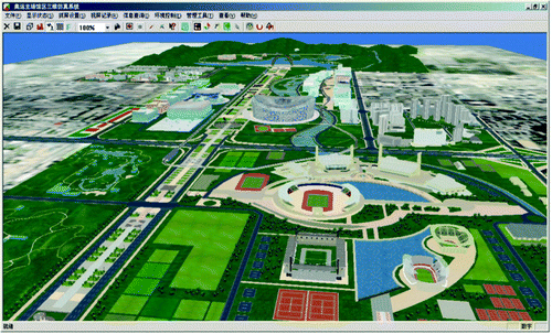
On the basis of virtual reality technology, the digital Olympic Games 3D simulation system is an environment information platform for the Olympic gymnasium and stadium by applying and integrating remote sensing, geographic information system, GPS and other technologies. According to the layout and design for the Olympic game sites and surrounding environment, 3D scenes of virtual reality and simulation were developed, and 3D models for the Olympic park, buildings of Olympic games and surround areas were also built. These scenes basically reflect the ideas of the Department of Planning of the organising committee of the 2008 Olympics ().
Figure 1. 3D virtual reality scene of the Beijing 2008 Olympic Park (image courtesy of CEODE).
Global change research based on digital earth
The development of the Digital Earth concept and related technologies, together with the results of Global Change research are two areas where rapid progress has been made over the past few years. This, together with developments in geoinformatics, are resulting in global spatial infrastructures now being used as Digital Earth models, to enable multiple attributes to be obtained from any location on Earth. At a recent Earth System Science Partnership (ESSP) Open Science Conference on: ‘Global Environmental Change: Regional Challenges’, held in Beijing, China from 9 to 12 November 2006, it was stressed that there was a need for a new system of global environmental science. This is where the Digital Earth approach as described in detail in several other papers in this issue, fits in. The research results discussed below, all related to the millennium development goals, show that topics such as forest fires, deforestation, desertification, wetlands, spread of diseases, sea level rise, etc. are all tied into the broader issue of global security. (German Advisory Council on Global Change Citation2007)
The country has been classified into five zones, mainly on the basis of latitude. In the far north, (zone 1), the area is characterised by taiga forests, westerly winds, and often experiences severe forest fires. Zone 2 consists mainly of Gobi desert, with occasional oases, large areas of wind blown loess deposits, and in this zone there are large problems with dust and air pollution, caused by deforestation, desertification, and numerous underground coal fires. Zones 3 and 4 are approximately at the same latitude, but because of the Tibet Plateau, have vastly different environmental conditions. Whilst Zone 3 is typified by high altitude, low oxygen, strong sunshine and glaciers, Zone 4, because of the blocking effect of the Himalayan mountains, has a sub tropical monsoon climate, with mixed evergreen forests and large areas of ricefields. Zone 5, in the south of the country is characterised by tropical rainforest, typhoons, and coral reefs. The following sections describe the main global change actions occurring in each of these five zones.
Global Change Zone 1: Forest and grassland fires in Northern China.
The Heilongjiang Province in North East China lying in the latitude range of N. 45° to N. 55° has the largest forest area in China. It is situated in the same high latitude zone as the taiga forest zones in Russia, Canada and Mongolia.
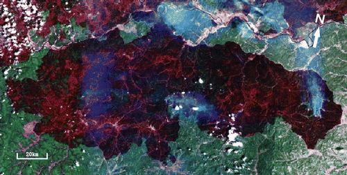
Some 20 years ago, a very large forest fire occurred in the Da Xing An Ling mountain area of this province, covering an area of more than 100 million hectares (Cahoon et al. Citation1994). It was first detected and subsequently regularly monitored by the Chinese Meteorological satellite Feng Yun.This fire stimulated considerable research into the causes and mechanism of forest fires (Corey et al. Citation2006, Keane et al. Citation2006). is a Landsat colour composite of the 1987 forest fire, covering parts of N.E. China, Russia, and Eastern Mongolia.
Grassland fires in western and central areas as well as in Mongolia, occur frequently, spreading out from the west in an easterly direction, fuelled by the prevailing westerly winds. The Chinese government, via the China Meteorological Administration has set up a monitoring system for the easy detection monitoring and control of forest fires using thermal infrared remote sensing methods. This model was first developed and tested in Jilin Province in eastern China and subsequently became the system adopted for the national forest fire monitoring system. One of the concrete results of this system has been the successful blocking of the Mongolian grassland fires in to China.
As a result of the research into the mechanisms of forest and grassland fires over the past 20 years, a better understanding into the causes and ecological effects efforts of such fires has been obtained. The phenomenon of fires is a natural process of forest metabolism, and is therefore clearly not only caused by human actions (Keane, et al Citation2006, Chen and Cheng, Citation2001).
Temperate region desertification and dust storms (Global Change Zone 2, Figure 2)
With the rapid urbanisation and increase in the welfare of Beijing, the Beijing Municipal government has invested much money and other resources to decrease the influence of sand and dust storms in the city, especially with a view to improve air quality before the Beijing Olympics in August 2008. Although forest shelter belts and wind breaks were set up, it soon became clear that these are useless to prevent dust from coming 3000 metres up in the atmosphere from western China.
In addition, the air currents from the Shanxi plateau also transport much dust to Beijing (Ren, et al. Citation2003). The book ‘Yellow Cloud from Thousands of Miles’ by Zeng Qingcun (Citation2006) provides many details and examples of dust transport in China, and showed how coal dust from Shanxi Province is transported to Beijing, especially in the autumn. The sand transport is mainly from northwest Mongolia, Gansu and Inner Mongolia regions (Derbyshire et al. Citation1998, Tsolmon et al. Citation2008). Joint research by Chinese and Japanese scientists on loess dust has shown that such dust reaches the Korean peninsula, Japan, Taiwan and even beyond to Hawaii (Naoko Iino and Kisei Kinoshita Citation2001).
Back in the 1950s, Russian scholars held the view that loess was principally driven by hydrology. However, research by the first author, together with Russian scientists Gerasimov and Kovda along the south bank of the Yangtze River, proved that there was loess accumulation underneath a basalt coverage, which provides strong evidence against the hydrological theory. Chinese researchers have made a systematic study of the loess along the Yellow River. Deposits of up to 600 m thick are clearly windborne. Thus, in contrast to the alluvial loess deposits in Europe, loess in Central Asia results mainly from sand deposition by wind transport, and is a process that has been going on for 10 000 years, during which time numerous humous interlayers of black soil have formed (Zhu and Zhu Citation1990, Zhu and Ren Citation1992).
Thus loess is a soil type formed by deposition of wind transported sand over long time periods. The idea of stopping shifting sand dunes in localised areas in China has been abandoned and replaced by a deeper understanding of this global change phenomenon, something probably already understood by the nomadic herdsmen on the grasslands of Inner Mongolia centuries ago (Genderen van and Squires Citation1994, Geist Citation2005).
Underground coal fires
The spontaneous combustion of coal seams is a major problem in most coal mining areas of the world. Underground coal fires are widely reported in countries such as the USA, Australia, India, and China. As the largest producer of coal in the world, China is particularly affected by this problem. The areas prone to spontaneous combustion of coal extends some 4000 km in West-East direction from the Xinjiang Autonomous region in the north west, to Heilongjiang Province in the far north east, and some 750–800 km in North-South direction, covering almost exactly the same areas as Global Change Zone 2 of .
Figure 2. Latitudinal zones of Global Change areas in China.
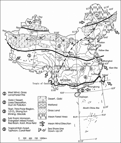
Figure 3. Landsat image segment of the major forest fire in N.E. China in 1987 (image courtesy of CEODE).
In a recent paper (Chen et al. Citation2007(b)), it was estimated that some 100 to 200 million tonnes of coal are burnt each year. Besides resulting in a major economic loss, the large amounts of CO2 and other harmful gases produced by these coal fires has a significant effect on global warming. (Genderen van and Guan Citation1997). Earth observation data has shown to be particularly useful for detecting the fires, measuring them (size, depth etc) modelling the fires (direction and speed of fire front, amount of coal burnt, etc.), and monitoring the effects and efficiency of the fire fighting efforts (Zhang et al. Citation1999, Peng et al. Citation1997). The fires contribute some 2–3% of global CO2 discharges. This is more than double the TOTAL CO2 production of the Netherlands (Rosema et al. Citation1995)
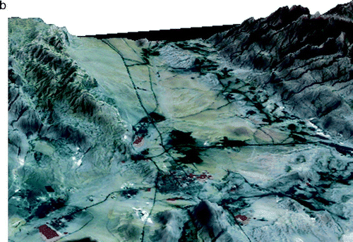
Again, the Digital Earth approach of using multi-scale, multi-temporal, multi-resolution and fused data sets are most appropriate to study and understand this important topic in global change research. Figures and Figure show some 3D models of coal-fire areas in the Junghar Basin in the Xinjiang Autonomous region in N.W. China (Figure ), and in the Wuda area of Inner Mongolia (Figure ). On the cover of a recent issue of the International Journal of Remote Sensing, several more 3D models of coal fires in China are presented (Chen et al. Citation2007(a)).
Figure 4a. 3D model of coalfires in the Kelazha anticline in Xinjiang, N.W. China, with a thermal infrared image draped over a DEM of the area.
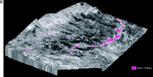
Figure 4b. 3D model of the Wuda coal fire area in Inner Mongolia, produced with ASTER data.
Deforestation and carbon sequestration
The Ministry of Forestry in China estimates that forests contribute about 89% to the reduction of CO2 discharges. However, forestry researchers are still not unanimous in their views on the role of forest carbon sequestration. (Metz et al. Citation2007, Yamagate Citation2006). Thus, similar to the discussion on whether shelter forests consume water or conserve water, experimental data on whether forests absorb large amounts of CO2 or absorb oxygen and discharge CO2 gases are still inconclusive. Of course, the overall ecological effects of forests, reforestation and having more green vegetation coverage are environmentally beneficial. Many large reforestation projects are being carried out in China, which have resulted in the percentage forest cover having increased from 17% in the 1950s to more than 35% in 2007. In some provinces such as Fujian, Jilin, and Heilongjiang, forest coverage is as high as 60% to 70%.
Many land use changes have occurred under this policy of returning farmland to forest and grasslands, whilst attempting to maintain the ‘red line’ of the minimum amount of farmland to provide the food for China's large population. This fits with many studies made on land use change internationally (Rudel Citation2005, Lambin and Geist Citation2006).
At present, one of the largest projects in China is the ‘Three North Shelter Forest’, consisting of the construction of a belt of trees extending over 2000 km from the west to the east of China, just south of the temperate desertification region
Protection and Utilisation of Wetlands
Wetlands are often refereed to as being ‘the lungs of the Earth’. Hence the Digital Earth approach to the protection of wetlands has become a major focus for global change research. In China, most of the wetlands occur in the Heilongjiang River basin and in the Ruoergai region, both in the high latitude areas of Zone I of . The other wetland areas are mainly along the coastal zone.(An et al. Citation2007). China only started its wetlands conservation programme some ten years ago, when it dedicated some 3% of its territory for national protection, with 14 key conservation areas as part of the ‘Wetlands International China Programme’ (Zhou Citation1996).
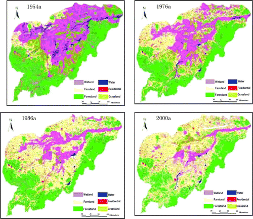
During the 1960s China embarked on a major programme to reclaim wetlands and convert them into agricultural land. The Three River Plain in N.E China was changed into the largest national grain and soybean producer.(Han and Tian Citation2005). The Ruoergai wetland in the upper reaches of the Yellow River was reclaimed, over-grazed and destroyed by digging ditches, with the purpose of increasing water volume. Since then, although some formerly reclaimed wetlands are being returned to wetlands (e.g. in the Dongting Lake and Poyang Lake areas), only small areas have really recovered their wetland functions. Wetlands are still being destroyed at a fast rate. Figure gives a dramatic example of this. Here, Zhang (2007) has mapped the areas of wetlands in the N.E. Plains of China, to show the large increase in agricultural land at the expense of the former wetland areas.
Figure 5. Destruction of wetlands in central part of Sanjiang Plain, in N.E. China (after Zhang 2007).
Over the past 20 years, some 160 lakes of the former 208 lakes in the Jianghan plain have disappeared. These processes can be quantitatively monitored by earth observation satellites.
Irrigated rice fields function as type of seasonal wetlands during part of the rice crop phenology. However, because of the ever greater shortage of irrigation water, the area under irrigated rice is decreasing rapidly (Yuan et al. Citation2002). In their research in the wetland area of the Yangtze River (which cover an area of 215.000 ha), they found that the rich biological resources of the area are under threat. Of the 136 species of vascular plants, 150 bird species and 68 species of benthic macro-inverterbrates, many are expected to disappear over the coming years because of land reclamation, water pollution, movement of sediments in the Yangtze River, and the effects of tides and waves.
Another type of wetlands disappearing rapidly are the coastal salt flats. These are frequently being converted to aquaculture. Under the 2007 strict national land management and protection policy, the coastal salt flats have become targets for coastal and offshore industrial zones. The Tianjin Development Zone is a clear case in point, and similar industrial developments in Suzhou, Hangzhou and Zhujiang deltas further threaten biodiversity (Zhang et al. Citation2006).
Another classical example of the destruction of natural wetlands is the case of the Dian Lake near Kunming in southeastChina. In the 1940s this area had a water body area of 320 km2, a wetland area of 100 km2, plus some 200 km2 of rice fields. However, rapid urban expansion and agricultural development have converted this area into the largest horticultural area of South East Asia. In addition, water quality has degraded because of waste water and ore waste due to the large-scale phosphate mining.
Thus the rapid loss of the natural wetland in China, due to conversion to agriculture, industrial development, urbanisation, aquaculture, etc is a serious threat to biodiversity and wildlife (Liu et al. Citation2004).To compensate for the loss of natural wetlands, a common practice is to construct artificial wetlands. To test whether artificial wetlands, as habitats for water birds are good alternative to natural wetlands, Ma et al. (Citation2004) compared species richness, abundance and seasonal dynamics of water bird communities of natural (tidal areas) and artificial (aquaculture ponds) wetlands on Chongming Island. The results of their research indicated that the habitat preference of water birds showed seasonal differences: most of the shorebirds were found on tidelands in spring, whereas most of the natatorial birds were recorded in aqua cultural ponds in winter. Water birds preferred the tidelands rather than aqua cultural ponds in both spring and autumn. They conclude that natural wetlands are better habitats for water birds than artificial wetlands on Chongming Island. The water birds only use artificial wetlands when natural wetlands are unavailable or of poor quality.
Avian Influenza and the spread of diseases
Due to the changes in climate and ecosystems, there are serious challenges to scientists to study the global spread of emerging diseases such as SARS, Avian Influenza (bird flu), dengue fever as well as the more traditional ones of malaria.
Especially in China, with its large territory, the spread of bird flu, caused by the movement of migratory birds is causing increasing concern. Globally, there are some seven major routes followed by the birds on their way to the Arctic (Figure ).
Figure 6. Map showing the global routes of migratory birds.
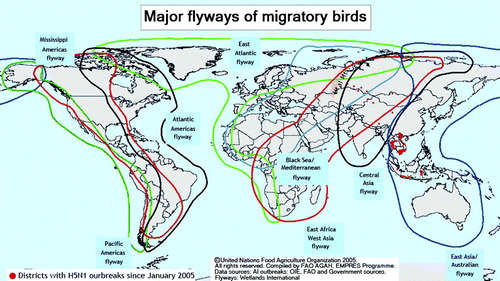
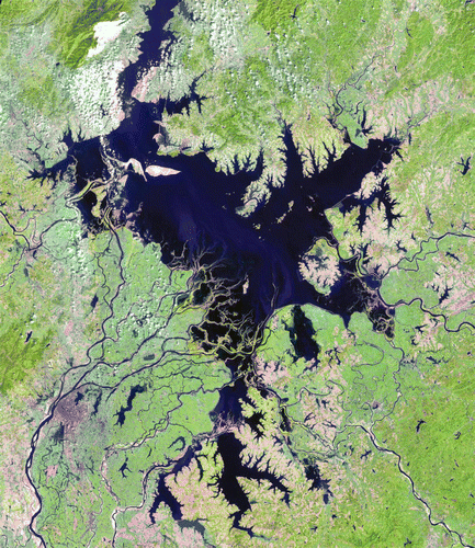
As can be seen, three of these routes cross China. To protect and monitor the population of the migratory birds and plot their movements on their trip south from North Earth Asia, the Chinese government has set up a series of protected ecological zones and national parks in the Yellow River delta, northern Jiangsu beaches, Chongming Island, Zhejiang, Nanji island, Poyong Lake in Jiangxi Province, Xiamen, Shenzhen and Hong Kong (Xiapu). Figure is a Landsat TM image segment of Poyang Lake, taken on 23 September 2000. This is one of the main wetland national parks specifically for migratory birds.
Figure 7. Landsat TM image (bands 5,4, 3 = RGB) of Poyang Lake, taken on 23 September 2000. (Image courtesy of CEODE).
Research results (during the period 2001–2005) from the monitoring of the birds as they fly south and then north again, showed that thousands of migratory birds were infected by the bird flu. When they congregate back in the Arctic area, they further spread the disease amongst themselves and then distribute it along the other global migratory routes across Europe to Africa and other parts of the world.(see ) The Digital Earth concept, looking at such effects at a multi- scale level, and using multiple sources of data and integrated technologies such as remote sensing ( to map some of the physical parameters such as soil temperature, humidity, evaporation rates, thermal inertia, vegetation indices, land use mapping) and GIS (for studying the spatial relationships, time-series modelling and production of alternative scenarios) can help prepare the strategy for a preparedness plan to combat the emergence and spread of such diseases. The research result presented by Oyana et al. in Citation2006, showing the spatio– temporal distribution of the reported cases of the Avian Influenza H5N1 in southern China during 2004, illustrate this approach.
Tibet Plateau uplift and subtropical monsoon climate (Zones 3 and 4 of Figure 2)
The uplift of the Qinghai-Tibet Plateau fundamentally changed the climate and ecological patterns in the south east part of the Eurasian continents. The uplifted Qinghai –Tibet Plateau (Zone 3 on ) formed an Alpine permafrost plateau climate region, dotted with glaciers and frozen soil, inland lakes and grasslands, and the Himalayas, which formed a monsoon climate barrier from the Indian ocean. This allowed the Western Pacific monsoon to have access to a much larger area of Eastern China,the Korean peninsula and Japan.(Zhang D.F. Citation2000).
As a result, the area south of the Yellow River (Zone 4 in ) is not desert as are other areas of the world at a similar latitude, but instead, because of the El Nino effects, mixed forest now cover previously existing desert basins. This has resulted in it becoming one of the world's green areas, thereby enabling the area to sustain a high population density, because of the high agricultural production capacity. (Clark et al. Citation2004). For example, the Sichuan Basin, West Lake Basin and the Yangtze and Pearl River deltas are regions, with high agricultural productivity and economic prosperity, compared to other regions in the world at the same latitude. This zone has also allowed the growth of some of the world's largest cities.
The Qinghai- Tibet Plateau, because of its altitude, acts as the’ Water Tower of Southeast Asia’, as most of the large trans-national rivers originate here. The recently complete Qinghai –Tibet railway line, the world's highest railroad, was one of the first major infrastructure projects where an environmental impact assessment (EIA) was carried out prior to construction, in order to protect the environment and ecology of the region. Issues such as the permafrost, protection of the grasslands and the movements of the Tibet antelope were taken into consideration (Li et al. Citation2007).
Results of detailed remote sensing research in this area has shown that the number of lakes larger than 2 km2 on the Plateau have increased from 200 to 800 over the past few decades. At the same time, temporal monitoring of satellite imagery of this region has shown the number and size of the glaciers to be decreasing Dai et al. (Citation2007) have shown by means of a long time series of NOAA-AVHRR data that despite all the environmental protection measures, the area of grasslands is decreasing, areas of deserts are increasing. Fielding (Citation1996) has also provided a detailed geological account of the uplift and erosion of the Tibet Plateau region.
Sea-level rise
Most of the world's population is located near the coastal zone, and many major cities are below 50 m above sea-level. Hence, sea-level rise, coupled with land subsidence are a major concern to Global Change researchers (Javier-Diez Citation2000).The Delta works in the Netherlands are well-known as an example of an infrastructure project to protect the country from sea-level rise. Similarly, the tidal protection embankment in Venice is an example of an infrastructure project to protect the city from flooding as a result of land subsidence.
The Division of Earth Sciences of the Chinese Academy of Sciences organised a team of experts to conduct a comprehensive survey on sea level changes since the Quaternary period. This survey was conducted from 1999 to end of 2002. The results of the survey showed that along China's 18 000 km long coastline, some parts of the coastal zone were rising, whilst in other places they were sinking. This is also reported by other international researchers (Fyfe. et al. Citation1999). Hence, it is important to consider not only the influence of melting of Polar ice-caps when studying sea level rise, but also long term geological influences which still cause many shorelines around the world to rise higher above sea level (Douglas and Pelther Citation2002). See also , which shows those parts of the Chinese coastline being up lifted.
The Yellow River Delta has seen an annual increase in the land area of 2–3km2 since 1855. Land reclamation from the sea has resulted in a large increase of fertile agricultural land. In addition, oil extraction from land areas is nine times cheaper than oil extraction offshore. The Shengli oil field in the Yellow River Delta and Bohai sea area is using this fact to aid in oil production. Similarly, large areas of the sea are being reclaimed in the Yangtze and Pearl river deltas (Huang et al. Citation2004, Chen and Stanley Citation1998).
However, the rapid process of urbanisation, resulting in the establishment of large cities in the alluvial delta plains, have resulted in land subsidence, due to extraction of ground water, coupled with other local factors such as geology (Chen and Wang Citation1999). Most of the large cities being affected by land subsidence, such as Shanghai and Tianjin are being closely monitored and controlled by a dense network of levelling and GPS stations together with the use of differential SAR interferometry, especially by the Permanent Scatterer/INSAR technique. In Suzhou, this method is used to artificially recharge the groundwater level, to prevent further land subsidence.
It is the Digital Earth approach of coupling global studies of sea-level changes with the detailed, sub-centimeter level measurements at the local level of individual cities that offer the best solution to a better understanding of the issues involved, so that the decision makers can plan appropriate measures such as infrastructure projects, re-siting of facilities etc., to minimise the impact of such changes.
Conclusions
The Digital Earth approach uses a variety of earth observation data from the global to the local scale, including information of the solid earth, of the global atmospheric circulation patterns, and detailed GPS data, which provide the Global Change community with a wealth of quantitative data for modelling global changes. By using quantitative spatial analysis methods, Digital Earth allows a deeper understanding of the global change mechanisms, allowing us to evaluate global change regional responses and zonal characteristics caused by the earth's rotation. Furthermore, the Digital Earth approach enables us to display and demonstrate the global change mechanisms and their temporal effects, in order for decision makers to make better regional and global based environmental protection schemes.
The research results of global change studies in the various latitudinal zones of China lead to the conclusion that the changes occurring are a complex mixture of naturally occurring processes and man-induced effects. Hence the authors propose that the communities involved in Digital Earth modelling and Global Change research, cooperate closer to overcome the limitations inherent in the current ‘conventional’ scientific approach where scientists have typically stayed within their respective scientific boundaries. Such an integrated approach will enable us to build the next level of scientific infrastructure required to understand and predict naturally occurring environmental changes, as well as that of coupled human-environmental systems.
Chinese scientists play an active role in many international research programmes and projects in the field of Digital Earth and Global Change studies, such as IGBP, IPCC, ISDE, Global Mapping, GSDI, Planet Action, to name but a few. It is only by means of such international co-operation that the research results of the local changes described in this paper occurring in the various Latitudinal Zones of Global changes, can be placed in a global context, as they impact other regions on the Earth.
About the authors
Shupeng Chen, born in 1920, graduated from Zhejiang University with an MSc degree in 1947. Professor Chen has initialised research into automated cartography, remote sensing and geographic information systems. Currently his main research interests are in earth observation, geoinformation science and Digital Earth. He is an Academician of the Chinese Academy of Sciences (1980), Fellow of the Third World Academy of Sciences (1992) and Academician of the International Eurasian Academy of Sciences (1993). He has published several books, including one on ‘Geoinformation Science and Digital Earth’(2005), as well as some atlases and dictionaries. These have won him over 30 national and international awards, including the national Award on Distinguished contribution to China (1991),special Golden Award for environmental Science (1993), the O.M. Miller Cartographic Award from the American Geographical Society (1998) and the Carl Mannerfelt Gold Medal from the International Cartographical Society (2001).
John van Genderen has been carrying out remote sensing research and projects in many parts of China for more than thirty years. During this long period he has witnessed and participated in the rapid developments in earth observation in the country. He has organised many training courses, workshops, seminars and conferences in China to promote the understanding of basic remote sensing theory and technology, by coupling this with problem solving in several major applications of global change. He has hosted numerous Chinese MSc., PhD and post-doctoral scholars at the ITC and has been involved in the Digital Earth movement since the first International Symposium held in Beijing in 1999. His major research field is earth observation data fusion.
Acknowledgements
The authors wish to thank the many Chinese researchers who have contributed their research results to this study. The authors also gratefully acknowledge the support of the Centre for Earth Observation and Digital Earth in Beijing, which kindly provided many of the satellite images used to illustrate the global change aspects.
Related Research Data
References
- An , S.Q. 2007 . China's natural wetlands: past problems, current status and future challenges . Ambio , 36 : 335 – 342 .
- Cahoon , D.R. 1994 . Satellite analysis of the severe 1987 forest fires in northern China and southern Siberia . Journal of geophysical research , 99 : 18627 – 18638 .
- Chen , Y . 2007(a) . Detection of coal fire . IJRS , 28 : 3171
- Chen , Y . 2007(b) . Detection of coal fire location and change based on multi-temporal thermal remotely sensed data and field measurements . IJRS , 28 : 3173 – 3179 .
- Chen , Z. and Stanly , D.J. 1998 . Sea-level rise on eastern China's Yangtze delta . Oceanographic literature review , 45 : 1334
- Chen , S.P. and Cheng W.M. , 2001 , World Forest Watch by Digital Earth . Journal of remote sensing , Vol. 5 . pp 321 – 326 (in Chinese)
- Chen , S.P and Guo , H.D. 2000 . Digital Earth and Earth Observation . Acta geographica sinica , 55 : 9 – 14 .
- Chen , Z.Y. and Wang , Z.N. 1999 . Yangtze Delta China : Taihy Lake-level variation since the 1950's, response to sea-level rise and human impact . Environmental geology , 37 : 333 – 339 .
- Clark , M.K. 2004 . Surface uplift, tectonics and erosion of eastern Tibet from large-scale drainage patterns . Tectonics , 23 ( 1 ) : 813 – 816 .
- Cory , G.J. 2006 . Comparison of the sensitivity of landscape-fire-succession models to variations in terrain, fuel pattern and climate . Landscape ecology , 21 ( 1 ) : 121 – 137 .
- Dai , J.G. et al. 2007 , Land cover change and climate vicissitude research in the headstream region of the Yellow Riwer in the nineties of the Twentieth Century . Proceedings of ISPRS Symposium ‘Mapping Without the Sun’ Archives of the ISPRS , Vol. 36. Part 7 (C54, pp. 174–179) .
- Derbyshire , E. 1998 . Provenance, transport and characteristics of modern Aeolian dust in western Gansu Province, China, and interpretation of the 310 Washington et al. Quaternary Loess record . Journal of arid environments , 39 : 497 – 516 .
- Digital Earth Prototype System Research Team , 2005 , Digital Earth Prototype System (DEPS CAS 1.0) , Unpublished Report for the Innovation Program of the Chinese Academy of Sciences, 159p .
- Douglas , B.C. and Pelther , W.R. 2002 . The puzzle of global sea-level rise- measuring the rate of sea-level rise over the past century requires modeling the behavior of Earth's crust over the past 20,000 years . Physics today , 55 : 35 – 41 .
- Ehlers , M. 2008 , Geoinformatics and Digital Earth Initiatives . International journal of digital earth , 1 ( 1 ).
- Fielding , E.J. 1996 . Tibet Uplift and Erosion . Tectonophysics , 260 : 55 – 84 .
- Fischer-Kowalshi , M. and Haberl , H. 2007 . Socio-ecological transitions and global change: trajectories of social metabolism and land use , Cheltenham, , UK : Edward Elgar Publishing .
- Foresman , T. 2008 Evolution and implementation of the digital earth vision technology and society . International journal of digital earth , 1 ( 1 ).
- Fyfe , J.A. 1999 . Erosion and sedimentation associated with the last sea level rise offshore Hong Kong, South China Sea . Quaternary international , 55 : 93 – 100 .
- Geist , H.J. , 2005 . The causes and progression of desertification . Ashgate studies in environmental policy and practice , London : Ashgate Publishing .
- Genderen , J.L. van , 1999 . The potential of virtual reality imagery to the digital earth concept . Proc. 1st International Symposium on Digital Earth , Beijing .
- Genderen , J.L. van and Guan , H.Y. , 1997 . Environmental monitoring of spontaneous combustion in the North China coalfields . European Commission Report INCO-DC .
- Genderen , J.L. van and Squires , V. 1994 . Monitoring and management of fragile ecosystems in Shanxi-Shaanxi , Inner Mongolia, PR China’ (Asian Development Bank publication, T/A: 1615-PRC, Vol. 1: Executive Summary, 27 pp; Vol. 2; Main Report: 188 pp; Vol. 3 Appendices, 80pp)
- German Advisory Council on Global Change . 2007 . World in transition: climate change as a security risk , Berlin : Springer-Verlag .
- Goodchild , M. , 2008 . The use cases of digital earth . International journal of digital earth , 1 ( 1 )
- Gore , A. , 1998 . The Digital Earth: Understanding our planet in the 21st Century . Presented at the Californian Science Center, Los Angeles, California, 31 January 1998 .
- Han , M. and Tian , X. 2005 . Wetlands study in China . IEEE instrumentation and measurement magazine , 8 : 40 – 43 .
- Huang , Z.G. 2004 . Coastal inundation due to sea-level rise in the Pearl river delta, China . Natural hazards , 33 : 247 – 264 .
- Javier-Diez , J. 2000 . A review of some concepts involved in the sea-level rise problem . Journal of coastal research , 16 : 1179 – 1187 .
- Keane , G. et al. , 2006 . A classification of landscape fire succession models: spatially explicit models of fire and vegetation dynamics . Ecological modelling . Produced by Fire Fast Track Initiative .
- Keane , R.E. 2006 . “ Understanding global fire dynamics by classifying and comparing spatial models of vegetation and fire dynamics ” . In Terrestrial Ecosystems in a Changing World , Edited by: Canadell , J. 139 – 148 . GCTE Synthesis Book .
- Lambin , E.F. and Geist , N.J. , 2006 . Land use and land cover change: local processes and global impacts . Berlin : Springer-Verlag , IGBP Book Series No. 9 .
- Li , Z. , et al. , 2007 . The detection of subsidence at permafrost frozen area in Qinghai-Tibet plateau . Proceedings of ISPRS Symposium 'Mapping without the Sun'Archives of ISPRS , Vol. 36, Part 7 (C54, pp. 130–134) .
- Liu , H.Y. 2004 . Impacts on wetlands of large scale land use changes by agricultural development . Ambio , 33 : 306 – 310 .
- Ma , Z.J. 2004 . Are artificial wetlands good alternatives to natural wetlands for water birds? A case study on Chongming Island, China . Biodiversity and conservation , 13 : 333 – 350 .
- Metz , B. , et al. 2007 . IPCC Special Report on Carbon dioxide Capture and Storage . Cambridge University Press .
- Naoko , I. and Kisei K. , 2001 . Properties of AVHRR images of Asian Dust in April 1997 . In: Satellite imagery of Asian dust events , Kagoshima University Press , Japan , pp. 23 – 28 .
- Oyana , T.J. 2006 . Spatiotemporal distributions of reported cases of the Avian influenza H5N1 (bird flu) in southern China in early 2004 . Avian diseases , 50 ( 4 ) : 508 – 515 .
- Peng , W.X. Genderen , J.L. Van . 1997 . Estimating the depth of underground coal fires using data integration techniques . Terra Nova , 9 : 180 – 183 .
- Ren , Z.H. 2003 . The regional characteristic of the atmospheric environment and the impact of dust storms in Beijing . Journal of remote sensing , 5 ( 2 ) : 49 – 56 .
- Rosema , A. , et al. , 1995 , Environmental monitoring of coal fires in North China . BCRS Report, No. 9329 .
- Rudel , T.K. , et al. , 2005 . Forest transitions: towards a global understanding of land use change . Global environmental change , 15 , 23 – 31 .
- Steffen , W. and Tyson , P. , 2001 . Global change and the Earth System: a planet under pressure . The Global Environmental Change Programme , IGBP Science, Elsevier, Vol. 4. 32 .
- Stern , N. , 2006 . The economics of climate change (the Stern review) . Cambridge University Press .
- Tsolmon , R. , et al. , 2008 . Monitoring the source of trans-national dust storms in North East Asia . International Journal of Digital Earth , 1 ( 1 ).
- Yamagate , Y. 2006 . Terrestrial carbon budget and ecosystem modelling in Asia . Global Change Newsletter. , 67 : 6 – 7 .
- Yuan , X.Z. 2002 . The ecological and environmental characteristics and conservation of the wetlands in the Changjiang Estuary, China . The environmentalist , 22 : 311 – 318 .
- Zhang , D.F. 2000 . Eco-environmental effects of the Qinghai-Tibet plateau uplift during the Quaternary in China . Environmental geology , 39 : 1352 – 1358 .
- Zhang , X.L. 2006 . Changes of hydrological environment and their influences on coastal wetlands . Environmental monitoring and assessment , 119 : 97 – 106 .
- Zhou , X.Y. 1996 . Wetlands International China Program established . Beijing review , 39 : 32
- Zeng , Q.C. 2006 . Yellow cloud from thousands of miles: research on East Asia sand storms , Beijing : Science Press .
- Zhang , S.W. 2006 . The land use and land cover spatial–temporal characteristics analysis for northeast China , Beijing : Science Press .
- Zhang , X.M. , Cassels , C.J.S. and Genderen , J.L. van . 1999 . Multi-sensor data fusion for the detection of underground coal fires . Geologie en Mijnbouw , 77 ( 2 ) : 117 – 127 .
- Zhu , X.M. and Zhu , Y.Z. 1990 . A preliminary study on Loess dust in China . Quaternary science , 10 : 234 – 239 .
- Zhu , X.M. and Ren , M.E. 1992 . The formation process of Loess Plateau in China and its management strategy . Journal of China water and soil conservation , 92 : 4 – 10 . http://www.fao.org/ag/againfo/subjects/en/health/diseases-cards/migrationmap.html