Abstract
The vast expanse of the Gobi desert across the Mongolian plateau experiences frequent dust storms. In this isolated region remote sensing techniques can provide an effective measurement of dust storms. Brightness temperature channels 4, 5 of AVHRR/NOAA satellite data, emissive bands of MODIS/TERRA satellite data and meteorological station measurement data were used and tested for dust and sandstorm mapping in the desert area of Mongolia and northern China. The differences between thermal bands in combination with geographic information system (GIS) layers were used for mapping in this study. The results show that dust and sand storm maps can be achieved from emissive bands for monitoring of dust and sandstorms. Most active dust storm sources can occur in truly remote areas where there is little or no human activity, although many sources are associated with areas where human impacts are well documented. Thus, on a regional scale dust mobilisation appears to be dominated by natural sources.
Introduction
Desert dust and related dust storms have major significance for the physical environment and the world's inhabitants. Deriving from surface material erosion in dryland regions the impacts of wind-blown desert dust are global in scope. Resulting dust storms can impact climate, air temperature, and influence ocean cooling (Goudie and Middleton Citation2006). Dust may affect soil formation, create geomorphologic formations in drylands, and remove cover from desert surfaces. At the same time, dust can transmit pathogens harmful to humans, impair respiratory function, cause air pollution, and disrupt communications and transport. Environmentally, such storms can accelerate soil erosion and encourage desertification. Rosenfeld et al. (Citation2001) identified that the effect of dust on cloud properties can be sufficient to inhibit precipitation. This reduction in precipitation can cause drier soil, which may lead to more dust, in a possible positive feedback loop. Such occurrences could potentially intensify drought conditions.In the Mongolian plateau of Inner Asia dust storms are recurring events (Middleton Citation1991).
Climatic variability and anthropogenic activities have led to an increase in dust storm activity in the region (Chen and Tang Citation2004). Debate continues over the source and changing frequency of dust storms along the northern China-Mongolian corridor (Natsagdorj et al. Citation2003). The impact of dust storms continues to be investigated as it affects land degradation and desertification processes in both countries (Wesche and Retzer Citation2005, Chen et al. Citation2005). Dust from this desert region becomes an international concern as it effects other nations, such as Japan and Korea, as it moves out to the Pacific Ocean as well as in a southwesterly direction towards Taiwan (Ma et al. Citation2001).
Dust activity is extremely sensitive to many environmental parameters, thus further research can address environmental and human concerns in this densely populated region. The identification methods of major sources in this study will enable us to focus on critical regions and to characterise emission rates in response to environmental conditions. With such methods, we will be better able to improve, global dust models and to assess the effects of climate change on emissions in the future. This can be done with remote sensing techniques.
Previously, satellite products have been useful in characterising dust transport over the oceans (Husar et al. Citation1997), although they cannot be readily used to identify sources because of difficulties associated with the large temporal and spatial variability of the albedo of land surfaces. Techniques based on measurements of upwelling thermal (infrared) emissions (Ackerman Citation1997), while useful, suffer from various difficulties including the effects of cloud and water vapour, so that it is difficult to detect coherent spatial patterns over dust source regions. It has recently been shown that the Total Ozone Mapping Spectrometer (TOMS) on the Nimbus 7 satellite yielded data that can be used to map the distribution of absorbing aerosols which largely comprised black carbon (i.e. soot) emitted primarily from biomass burning regions, and mineral dust most commonly emitted from sources in arid regions but also from occasional volcanic eruptions. The TOMS data show that on a global scale the dominant sources of mineral dust are all located in the Northern Hemisphere, mainly in North Africa, the Middle East, and Central Asia (Herman et al. Citation1997, Torres et al. Citation1998).
Satellite imagery clearly shows that dust aerosols often cover very large ocean areas. Indeed, the values of aerosol optical thickness associated with dust transport are much greater than those attributed to pollution aerosols transported from sources in North America, Europe, and Asia; furthermore, the dust plumes cover a much larger area, are more persistent, and occur more frequently than those associated with pollutant aerosols (Husar et al. Citation1997). Owing to the recognition of the importance of atmospheric aerosol properties (Tegen et al. Citation1996), interest in developing methods to retrieve such information from satellite data has increased. Several methods have been developed to identify the signal related to the radiative effect of atmospheric aerosols, including single and multiple channel reflectance, multi-angle reflectance, contrast reduction, polarisation, and thermal infrared (TIR) emission (King et al. Citation1999). Several other dust aerosol models are being used for the daily forecasting of dust storms. These models are similar to the CARMA-Dust model in that they use data from standard weather models such as ETA, NOGAPS or MM5. The University of Malta and the University of Athens use a modified version of the ETA weather model to make dust forecasts over northern Africa. The TOMS aerosol algorithm is described in detail by Herman et al. (Citation1999) and Torres et al. (Citation1998). MODIS satellite sensors can provide more quantitative information on aerosol optical depth and properties, for example aerosol optical thickness, fine model fraction etc. (King et al. Citation1999, Remer et al. Citation2005).
Although big dust events occur every spring, there is limited research work carried out on dust storm sources in southern Mongolia and northern China. The present paper discusses the synergy of MODIS and NOAA satellites for mapping sand storms and their occurrence in some parts of Asia. It has been observed that every year from March to April yellow sand originates from Mongolia and China flies to the North Pacific archipelago and the west coast of America. A dust and sand storm study of such a phenomenon has useful applications in the meteorological field.
The distribution of the number of dust storm days occurs mainly in south Gobi region which borders China. The number of annual days with dust storms is less than 5 days over the central and northern Khangai, Khuvusgul and Khentei mountainous areas of Mongolia, 10–17 days over the western area of Great Lakes, and 20–37 days over the desert and the semi-desert areas in Mongolia ().
Figure 1. Dust storm occurrence by number of days in Mongolia.
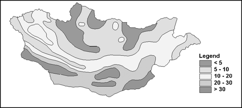
The highest frequency of dust storms is over three areas in the Gobi Desert in Mongolia. These include the south side of the Altai Mountains, around Ulaan-nuur Lake, and Zamiin-Uud. It should be noted that the distribution of dust storms has coincided well with the distribution of strong wind (Natsagdorj, Citation1982) and soil conditions.
Dust storms take on particular importance on the Mongolian plateau because of their significance for the formation of loess in China (Derbyshire et al. Citation1998). They also appear to have been a major source of the dust in Late Pleistocene ice layers in Greenland (Svensson et al. Citation2000). Moreover, according to Kes and Fedorovich (1976), the Tarim Basin has more dust storms than any other location on Earth, with 100–174 per year. There are stations to the northwest of the 750 mm annual rainfall isohyet that have dust storms on more than 30 days in the year (Goudie Citation1983). These storms can cover immense areas and transport particles to Japan and beyond (Ing Citation1969, Willis et al. Citation1980). Their frequency in Mongolia is most notable in the southern region of the Gobi, where Zamiin Uud has over 34 dust storms per year (Middleton Citation1991). Studies of dust loadings (Chen et al. Citation1999) and fluxes have suggested that there are two main source areas: the Taklamakan and the Badain Juran (Zhang et al. Citation1998). In all, it has been estimated that about 800 Teragrams of Chinese dust is injected into the atmosphere annually which may be as much as half of the global production of dust (Zhang et al. Citation1997).
Approach
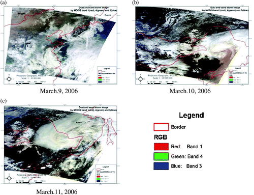
We attempted to monitor dust and sand storms using AVHRR/NOAA data from the NOAA receiving station of the National Remote Sensing Center (NRSC) and MODIS/TERRA data from LP DAAC/NASA. For this purpose we used brightness of temperature differences in the thermal infrared bands from AVHRR/NOAA and the emissive bands of MODIS/TERRA. For the monitoring true-colour display three bands of MODIS 1(red), 4(green) and 3(blue) by detecting yellow sand when RGB is displayed in . Brown colour represents sand and dust storm. The figure shows dust and sand storms in the northeast Asia, which are in brown, moving to the North Pacific archipelago. It moves from southeast Mongolia to China's northeast and after 2 days it reaches Korea, Japan and the Japanese sea.
Figure 2. Dust and sand storm true colour composite images using MODIS data.
Brightness temperature difference index (BTDI) of two bands can distinguish dust storms and the density of dust and sand. BTDI is related to the particle size of sand and dust. In this research dust and sand storm images were determined by the following equations.
Figure 3. Dust and sand storm images derived from BTDI approach using MODIS data.
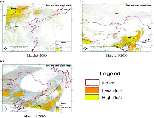
Figure 4. Dust and sand storm images derived from BTDI approach using NOAA/AVHRR data.
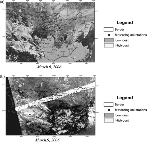
Equation Equation(1) was applied for MODIS data for March 6 and March 9, 2006 in Mongolia. The GIS layer of wind direction and meteorological stations were used in the Mongolian area (). Blue points mark locations of meteorological stations and black characters identify the wind direction ((a) and ). describes wind direction in Mongolia. The dust and sand storms area are represented in yellow (low dust) and orange (high dust) colour on the derived images from the approach (Figures ).
Figure 5. Dust and sand storm images derived from BTDI approach by MODIS data.
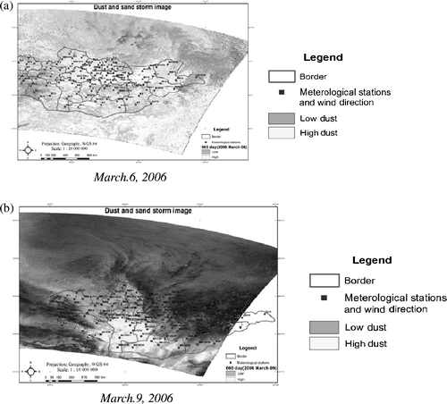
Table 1. Wind directions characters.
Digital values of temperature brightness images were converted into centigrade degrees. Selection for the dust storm area was based on brightness temperatures between −9 to 6°C, within the range where most Gobi spring dust events occur.
Southwesterly, westerly, northwesterly and northerly winds predominate during dust storms. If wind speed is less than 5 ms−1 a dust storm does not form. Wind speed was between 12 and 28 ms−1. Wind speed is usually from 6 ms−1 to 15 ms−1 during a dust storm. For the validation of our method we used meteorological station data that were recorded during sand storm occurrence in the study area.
There are 118 meteorological stations Mongolia; each day a different number of stations were covered by dust storms. outlines meteorological stations recording strong wind and describes how many dust storms occurrences are detected according to NOAA AVHRR and MODIS from 6 March to 9 March 2006. On 6 March from 22 potential stations seven were used to make records according to AVHRR data. Another 12 stations recorded with MODIS data have results similar to AVHRR in the dust and sand storm area. On 7 March 2006 strong wind was recorded at nine stations but the dust and sand storm area was out of Mongolian territory so data were not available. Daily records on 8 March 2006 showed strong wind at five out of twenty-two stations according to AVHRR data. Another seven stations recorded by MODIS data had similar results in the dust and sand storm area. Of 45 potential stations that documented dust occurrence in the area on 9 March 2006, ten were used by AVHRR data. The 14 stations that recorded by MODIS data showed similar results to the dust and sand storm area ().
Table 2. Meteorological stations recording strong wind according NOAA AVHRR and MODIS
Overall dust storm images derived from MODIS covered more stations than the images from NOAA for the same days.
Results
The results of the use of the two thermal infrared bands of AVHRR/NOAA data and emissive band of MODIS/TERRA data were compared with meteorological data from stations in southern Mongolia. The meteorological station data for dust and sand storm days was entered into the GIS format and investigated jointly with weather observed on those days.
Spring time dust and sand storms are common in the Gobi Desert of southern Mongolia and northern China and move to the Pacific Ocean. From the given approach we produced dust and sandstorm maps for the period 6 March to 9 March 2006. The true-colour images from MODIS bands of 1(red), 4(green) and 3(blue) were applied for detecting yellow sand (). Dust and sand storm images were made with GIS layers of wind speed and direction data at the meteorological station. This is most effective for dust and sand storm monitoring and modelling. Further quantitative studies using MODIS/TERRA emissive bands are important for a comparative study with other satellites and ground observation data from Lidar and numerical simulation based on meteorological models.
Many dust sources are associated with areas where human impacts are well documented, for example the Caspian and Aral Seas, the Tigris-Euphrates River Basin, southwestern North America, and the loess lands in China. Nonetheless, the largest and most active sources are located in truly remote areas where there is little or no human activity. Thus on a global scale dust mobilisation appears to be dominated by natural sources. Dust sources, regardless of size or strength, can usually be associated with topographical lows located in arid regions with annual rainfall under 125 mm. For this reason we selected the study area in the Gobi. Mapping reveals that the geometry of the dust distributions over specific regions can often be associated with geomorphologic features, in particular topographical lows in arid or semiarid regions, such as the Mongolian plateau.
A synergy between high-resolution MODIS and NOAA data may greatly enhance the operational success of satellite-based dust monitoring and mapping. This study represents an effective application of remote sensing techniques to create a dust and sandstorm map of the Mongolian plateau, concentrating on Mongolian station data. In the future information from China and other affected Asian regions can be examined for validation. The next step of dust research over Asia will integrate station data from across the region, and hence such trans-national dust storm studies will greatly contribute to the ‘Digital Earth’ concept.
About the authors
Tsolmon Renchin received her Bachelors degree in Applied Mathematics from Irkutsk University, Russia in 1989 and a Masters in Environmental Economics from the National University of Mongolia in 1997 and a PhD degree in Human Environmental Science from Chiba University, Japan in 2003. Currently she is a Professor at the National University of Mongolia and director of the NUM-ITC-UNESCO Remote Sensing/GIS laboratory. Her main interests are land cover monitoring and modelling, analysis of remotely sensed data, and recently human environmental economic analysis. She is currently co-chair of the ISPRS inter-commission working group VII/IV on derivation of global data, environmental change, and sustainability indicators for the period 2004–2008 and President of the Mongolian Geo-science and Remote Sensing Society.
Ochirkhuyag Lkhamjav works both for the Laboratory for Remote Sensing/GIS of NUM-ITC-UNESCO and Wildlife Conservation Society Mongolia Country Program. As a member of the Mongolian Geosciences and Remote Sensing Society, he is a graduate of the National University of Mongolia where he majored in meteorological engineering and completed Master course of Remote Sensing/GIS in this laboratory. After graduating five years working as a remote sensing specialist for the Mongolian Information and Computing Center where he processed NOAA and SeaStar satellite data to monitor snow and dust storms across the region. He also spent a short time with a Canadian-Mongolian mining company, QGX Co., Ltd. His research interests include image processing, spatial analysis and modeling, environmental monitoring and digital earth. He has published relevant research studies in journals and proceedings.
Troy Sternberg is a DPhil researcher at Oxford University studying the effect of water and land use change in the Mongolian environment. Focusing on the Gobi region work examines the relationship of drought with extreme winter events (dzuds), piosphere vegetation dynamics, water availability and quality, and herder interaction with the environment. NDVI values are applied to study areas to provide an ecological perspective over time. Work will contribute to the ongoing discussion of degradation and desertification in southern Mongolia and provide a point of comparison with environmental processes in Inner Mongolia, China.
Acknowledgements
The authors are grateful to EOS Gateway of LP DAAC/NASA for supplying MODIS/TERRA Level 1b data and the National Remote Sensing Center (Information Computer Center) of the Ministry of Nature and Environment and the Institute of Meteorology and Hydrology of Mongolia for providing NOAA-18 AVHRR data and their assistance in collecting ground truth data and pre-processing satellite data.
Related Research Data
References
- Ackerman , S.A. 1997 . Remote sensing aerosols using satellite infrared observations . Journal of geophysical research , 102 ( 17 ) : 69 – 79 .
- Chen , W. , Fryar , D.W. and Yang , Z. 1999 . Dust fall in the Takla Makan desert of China . Physical Geography , 20 : 189 – 224 .
- Chen , Y. and Tang , H. 2004 . Desertification in north China: background, anthropogenic impacts and failures in combating it . Land degradation development , 16 : 367 – 376 .
- Chen , Y. and Tang , H. 2005 . Desertification in north China: background, anthropogenic impacts and failures in combating it . Land degradation development , 16 : 367 – 376 .
- Derbyshire , E. , Meng , X. and Kemp , R.A. 1998 . Provenance, transport, and characteristics of modern aeolian dust in western Gansu Province, China, and interpretation of the 310 Washington Quaternary loess record . Journal of arid environments , 39 : 497 – 516 .
- Goudie , A. and Middleton , N. , 2006 . Desert dust in the global system . Berlin : Springer .
- Goudie , A.S. 1983 . Dust storms in space and time . Progress in physical geography , 7 : 502 – 530 .
- Herman , J.R. , Bhartia , P.K. , Torres , O. , Hsu , C. , Seftor , C. and Celarier , E. 1997 . Global distribution of UV-absorbing aerosols from Nimbus-7/TOMS data . Journal of geophysical research , 102 ( 16 ) : 911 – 922 .
- Herman , J.R. , Krotkov , N. , Celarier , E. , Larko , D. and Labow , G. 1999 . Distribution of UV radiation at the Earth's surface from TOMS-measured UV-backscattered radiances . Journal of geophysical research–atmospheres , 104 ( D10 ) : 12059 – 12076 .
- Husar , R.B. , Prospero , J.M. and Stowe , L.L. 1997 . Characterization of tropospheric erosols over the oceans with the NOAA advanced very high resolution radiometer optical thickness operational product . Journal of geophysical research , 102 ( 16 ) : 889 – 909 .
- Ing , G.K.T. 1969 . A dust storm over central China, April 1969 . Weather , 27 : 136 – 145 .
- King , M.D. , Kaufman , Y.J. , Tanre , D. and Nakajima , T. 1999 . Remote sensing of tropospheric aerosols from space: Past, present and future . Bulletin American meteorological society , 80 : 2229 – 2259 .
- Ma , C. , Kasahara , M. , Holler , R. and Kamiya , T. 2001 . Characteristics of single particles sampled in Japan during the Asian dust-storm period . Atmospheric environment , 35 : 2707 – 2714 .
- Middleton , N.J. 1991 . Dust storms in the Mongolian People's Republic . Journal of arid environment , 20 : 287 – 297 .
- Natsagdorj , L , 1982 . Atmospheric circulation and dangerous weather phenomenon over the territory of Mongolia . Publication of Hydro-Meteorological Research Institute of Mongolia, No. 6, Ulaanbaatar: 300 .
- Natsagdorj , L. , Jugder , D. and Chung , Y. 2003 . Analysis of dust storms observed in Mongolia during 1937–1999 . Atmospheric environment , 37 : 1401 – 1411 .
- Rosenfeld , D. , Rudich , Y. and Lahav , R. 2001 . Desert dust suppressing precipitation: A possible desertification feedback loop . Proceedings of National Academy of Science , 98 ( 11 ) : 5975 – 5980 .
- Remer , L.A , Kaufman , Y.J. , Mattoo , S. , Martins , J.V. , Ichoku , C. , Levy , R.C. and Kleidman , R.G. 2005 . The MODIS aerosol algorithm, products, and validation . Journal of the atmospheric sciences , 62 ( 4 ) : 947 – 973 .
- Svensson , A. , Biscaye , P.E. and Grousset , F.E. 2000 . Characterization of late glacial continental dust in the Greenland Ice Core Project ice core . Journal of geophysical research , 105 ( D4 ) : 4637 – 4656 .
- Tegen , I. , Lacis , A.A. and Fung , I. 1996 . The influence on climate forcing of mineral erosols from disturbed soils . Nature , 380 : 419 – 422 .
- Torres , O. , Bhartia , P.K. , Herman , J.R. , Ahmad , Z. and Gleason , J. 1998 . Derivation of aerosol properties from satellite measurements of backscattered ultraviolet radiation: Theoretical basis . Journal of geophysical research , 103 : 17099 – 17110 .
- Willis , D.M. , Easterbrook , M.G. and Stephenson , F.R. 1980 . Seasonal variation of oriental sunspot sightings . Nature , 287 : 617 – 619 .
- Wesche , K. and Retzer , V. 2005 . Is degradation a major problem in semi-desert environments of the Gobi region in southern Mongolia? . Erforsch. Boil. Ress. Mongolei , 9 : 133 – 146 .
- Zhang , X.Y , Arimoto , R. , An , Z. and Zhi , S. 1997 . Dust emission from Chinese desert sources linked to variations in atmospheric circulation . Journal of geophysical research , 102 ( 28 ) : 41 – 47 .
- Zhang , X.Y. , Arimoto , R. , Zhu , G.H. , Chen , T. and Zhang , G.Y. 1998 . Concentration, size-distribution, and deposition of mineral aerosol over Chinese desert regions . Tellus , 50B : 317 – 330 .