Abstract
The first pictures of the earth were taken from a balloon in the mid-19th century and thus started ‘earth observation’. Aerial missions in the 20th century enabled the build-up of outstanding photographic libraries and then with Landsat-1, the first civilian satellite launched in 1972, digital images of the earth became an operational reality. The main roles of earth observation have become scientific, economic and strategic, and the role of synthetic aperture radar (SAR) is significant in this overall framework. Radar image exploitation has matured and several operational programs regularly use SAR data for input and numerous applications are being further developed. The technological development of interferometry and polarimetry has helped further develop these radar based applications. This paper highlights this role through a description of actual applications and projects, and concludes with a discussion of some challenges for which SAR systems may provide significant assistance.
Introduction
The first pictures of the earth were taken from a balloon in the mid-19th century. The event was mentioned in an account by Gaspard Félix Tournachon, who took the first aerial photo of Paris in 1858, and thus started ‘earth observation’. Aerial missions in the 20th century enabled the build-up of outstanding photographic libraries. There was, however, a wait for Landsat-1, the first civilian satellite, launched in 1972, to obtain digital images of the earth from a height of about 900 km. At the time, many countries recognised the importance of having such satellite observation technology, as the new science of remote sensing supported assessments (e.g, soil management), analyses (e.g. meteorology) and prediction (e.g. agriculture). The main roles of earth observation have become scientific, economic and strategic, and the role of synthetic aperture radar (SAR) is significant in this overall framework. This paper highlights this role through a description of actual applications and projects, and concludes with a discussion of some challenges for which SAR systems may provide significant assistance.
Research and applications are developed by non-governmental organisations, research centres and industrial groups that aim to promote the use of computer programs, and especially remote sensing ones, for a better understanding of earth dynamics, and to prevent (and/or mitigate) natural and man-made disasters.
Remote sensing systems are classified as passive and active. Passive systems, which are based on optical sensors, capture radiation emitted from the earth's surface. Active systems, such as radar, transmit their own radiation and capture reflected data. Passive systems are classified as three types, depending on their sensors: multispectral, hyperspectral or infrared. Multispectral sensors capture radiation energy in various electromagnetic bands to produce images whose pixels are vectors (i.e. sets of scalar values, each associated with a band of the spectrum). Hyperspectral sensors are an extension of multispectral ones, as data are presented as a set of spectral band values, each corresponding to a very narrow band. Thus, hyperspectral images provide a spectral view of the reflected radiation at each pixel location of a given area. Comparing these data with the elements of a spectral signature library helps identify which kind of material has been identified for the corresponding pixel.
These passive systems enable the extraction of information for a given area, but all have an important drawback – they cannot capture data during darkness or in unfavourable weather conditions (e.g. rain, clouds, fog).
Active satellite systems have been developed on four principles:
-
The capacity for antennae to send out short electromagnetic pulses in a given direction;
-
The capacity for sensors to detect, also in a given direction, the reflected echo (that is greatly diminished);
-
The capacity for sensors to measure the time between emission and reception;
-
The capability of scanning a wide area.
Because they transmit their own radiation, and capture the returning echoes, radar systems are independent of solar illumination. Thus, they can be used night and day, and under whatever meteorological conditions may exist. Resolution depends on the size of the antenna – the larger the antenna, the better the resolution. SAR systems use platform movement to simulate a larger antenna. Emitted radiation used in SAR systems are centimetric ones and are classified into bands depending on their wavelength, λ:
-
X band: 2,40 cm < λ < 3,75 cm
-
C band: 3,75 cm < λ < 7,50 cm
-
S band: 7,50 cm < λ < 15 cm
-
L band: 15 cm < λ < 30 cm
-
P band: λ > 30 cm
These wavelengths have been chosen for two primary purposes:
-
They are not dissipated in the atmosphere and thus can penetrate clouds and other meteorological obstructions;
-
Their phase stability is sufficient to use them as coherent waves, and thus determine the distance of the target by comparing the transmitted radiation to the echo.
shows the features of some SAR systems. From , it appears that there is an evolution toward polarimetric systems with high-resolutions capabilities. The use of small SAR systems by emerging countries is also becoming more common. It also illustrates how the remote sensing field is dynamic, as shown by collaboration between countries.
Table 1. SAR features.
Although SAR imagery is not easily understood, even by scientists and technicians, it can contain important information which can be captured independently of meteorogical conditions. Consequently, SAR imagery has become indispensable for many applications.The following sections highlight the capabilities of SAR systems, compared to optical ones, for those applications that contribute to Digital Earth concepts. The challenges and possible improvements that could be considered for future satellites conclude the paper.
Polarisation and interferometry techniques
This background section summarises the basics of polarimetry and interferometry, as these technologies are key to the effective use of SAR systems, particularly in the framework of the applications presented in the body of this paper.
Polarimetry
SAR systems transmit electromagnetic waves that are almost completely polarised, with a given orientation and ellipticity. XY is a convention where X represents the emission orientation and Y the reception orientation.
-
Simple polarisation: HH, VV, HV, or VH;
-
Double polarisation: HH and HV, VV and VH, or HH and VV;
-
Quadrature polarisation: HH, VV, HV, and VH;
Some systems use a double polarisation technology to measure the phase difference between the two channels, which provides the polarimetric information. Quadrature-polarised radar systems measure the phase differences between all the channels, and also the signal magnitudes, which enables the evaluation of the target properties. This type of radar is considered ‘fully polarimetric’, and is called ‘polarimetric radar’.
By transmitting an electromagnetic wave with a given polarisation, receiving it through two orthogonal polarisation planes, and repeating this process with a second wave, the scattering matrix can be computed-a process is called ‘polarisation synthesis’. This matrix, that takes into account all the phase changes, is symmetrical for most targets when using a monostatic radar (i.e. emission and reception are carried out with the same antenna). The result (i.e. the scattering matrix) depends on the wavelength, but also on the acquisition angle. These two parameters have to be carefully chosen for each application. When using polarisation synthesis, one can determine which combination of polarisations (emission/reception) provides the best contrast between the target and its neighbourhood (e.g. ship versus sea).
It is also possible to represent the target-diffusing properties in terms of power, using the coherency matrix that can be computed from the same data as the scattering matrix. Its trace (sum of all diagonal elements) is equal to the total power diffused by the target (if one considers that this incident radiation has unit power). In addition, coherency matrix values are real numbers, (compared to scattering matrix ones which are complex numbers) that can be easily interpreted. In particular, they can be used to compute the polarimetric entropy, polarimetric anisotropy, and the α angle. Polarimetric entropy, H, quantifies the random feature of the diffusion process. H = 0 means that only one diffusion mechanism is involved in this process while H = 1 denotes that a set of such mechanisms are involved and thus the target depolarises the signal. The α angle is computed from the eigenvectors and gives the main diffusion mechanism. For example, α = 0° indicates that the scattering is dominated by the surface, α = 45° indicates that the scattering is bipolar or provided by a volume, and α = 90° indicates scattering by a dihedron or multiple reflections. Finally, it is possible to compute the polarimetric anisotropy from the ratio of the corresponding eigenvalues, which is a very useful parameter to indicate volume scattering targets.
The polarimetric signature is a function that shows the response from a target to a given set of polarised waves. In order to better understand this function, one only considers the backscattered waves that are polarised in the parallel direction (‘co-polarised’ signature), or in the orthogonal direction (‘cross-polarised’ signature) to the incident wave. Such a polarimetric signature does not give all the possible polarisation combinations between transmission and reception, but provides a visual model of the target-scattering properties.
The pedestal height is a useful parameter that can be evaluated from polarimetric signatures. It is the minimal intensity value of the normalised signature. In particular, it is efficient in characterising a component of the echo that is diffused but not polarised. Its value is zero when a wave is completely polarised, and increases when the signal is noisy, or results from multiple reflectors. Finally, the pedestal height provides a powerful way to estimate the various scattering mechanisms.
Interferometry
Interferometry is a class of techniques using several SAR images of the same area that have been captured from various viewpoints or at different times (Van Zyl Citation1997). The transmitting antenna receives the returning radar wave, but another antenna can also be used (a passive one) to capture the signal. By combining both signals in a coherent manner, the phase difference at each pixel of the image can be computed. The phase difference depends on the respective distances traveled by the two reflected signals, and thus, by knowing the respective positions of these two antennae (called the ‘baseline’), one can compute the corresponding height for each pixel. This technique is called ‘single-pass interferometry’.
A second technique consists of using a similar process (i.e. by signal comparison and phase difference evaluation), with data captured not in different locations, but at different times. As in the previous case, the phase difference between images is calculated. These images are supposed to have exactly the same geometry, or, the corresponding pixels are associated with a unique point on the ground. If the platform does not use exactly the same path, (as in the case of ‘cross-track separation’) and if the surface did not change between the two acquisitions, the scene topography can be computed. If the platform uses exactly the same path, we can measure the surface movements in the radar look direction. This technique, which evaluates radial movements, is called ‘repeat-pass interferometry’.
Usually, the ‘exact path’ condition is not verifiable and thus one cannot directly study radial movements. A solution to this problem is provided using the ‘differential interferometry’ technique. This consists of using three SAR images, two being captured at close intervals, and these provide support for computing the scene topography. By using one of these two images and the third one, the scene movement can be computed. When the time period between two image acquisitions is too long (e.g. several days or weeks), objects may be at another location or have another orientation. Errors resulting from such changes are considered a drawback in estimating ground variations, or an advantage if such information is to be used to conduct an image classification.
Other systems have been developed to produce interferometric images. One example of such a system is the multistatic radar systems, called the ‘interferometric wheel’ which uses one radar antenna for transmission, and several radar antennae for reception. As the information contained in a SAR image depends on its acquisition angle, more information is collected using such systems.
Another solution is provided by ‘tandem missions’. TerraSAR-X (launched in May 2007) and Tandem-X (to be launched in March 2009), will orbit between 500 m and 2 km apart, and provide interesting interferometric data. The project involves the German Aerospace Center (DLR) and EADS Astrium. One possible concern for this project is the precision of the satellite position determination (e.g. Envisat can provide such evaluations at centimetric accuracy).
Radar polarimetry and interferometry applications
In this section, descriptions of research results and applications that have been developed and demonstrated elsewhere are presented. The previous section provided details of polarimetry and interferometry including the principles terms, and techniques, as these are the most important ones for applications described in this section of the paper.
Ice
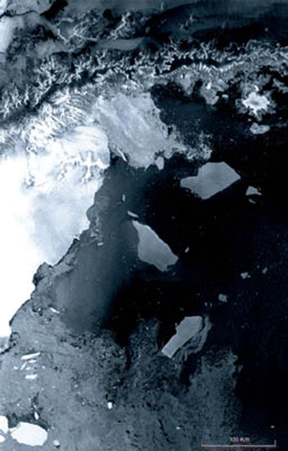
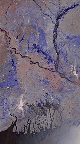
Clouds almost permanently cover many parts of both polar regions, and they are also in darkness (polar night) for almost half the year. Thus, optical systems cannot collect data, and SAR systems are used for remote sensing on these regions. In addition, many parts of the polar areas are flat, so that image capture is relatively easier. shows a typical scene along the Antarctic coast as an example.
Figure 1. Ice field collapse in the Antarctic (Larsen platform 3250 km2). Image from Envisat (ASAR), March 2002.
Polarimetry greatly improves information capture by clarifying ambiguities between water and ice (under a low incidence angle or high winds), as well as decreasing the confusion between water and thin ice (difficult to characterise ice signature in wet conditions and to identify the kind of ice). Two solutions to the ‘water and ice’ ambiguity problem are proposed:
-
Using a signal from orthogonal polarisation: knowing that earth, as well as ice, reflects waves in three dimensions, a signal in orthogonal polarisations (HV or VH one) will provide a higher contrast between sea water and ice (Scheuchl et al. Citation2001c).
-
Using H-A-a parameters: images computed from anisotropy (A) in C band and from entropy (H) in L band will also provide a higher contrast between sea water and ice (Scheuchl et al. Citation2001a).
The polarimetric signature is an efficient descriptor of ice structure, as ice evolves through four stages (Onstott and Gaboury Citation1989): new ice, grey ice, coarse grey ice, and desalinated sea ice. During this process, the maximum response received changes from that of HH to that of VV polarisation, owing to the change in dielectric constant of the ice (ice becomes coarser as its salinity decreases).
H-A-α parameters allow better classification of sea-ice (Scheuchl and Cumming Citation2002a): a low entropy (H) corresponds to ‘smooth ice’ as its diffusion is the most homogeneous (unlike earth which has high entropy). Anisotropy (A) is low for earth and high for ice, giving a higher contrast between earth and the four different types of ice. The value of α angle is low for ‘smooth ice’, confirming, with the low value of the entropy, that this result is provided mainly through surface scattering (coarser ice provides higher values for the α angle and for the entropy, associated with a greater volume scattering).
Fully polarimetric C and L band systems also provide important information, owing to their different penetration capabilities, that enable characterisation of surface and volume scattering properties. Differentiation of multi- and first-year ice types is possible using this difference.
Interferometry is capable of providing cartographic coverage of large ice areas (Joughin et al. Citation1996, Kwok and Fahnestock Citation1996), measurements of ice velocity (Goldstein et al. Citation1993, Joughin et al. Citation1995, Joughin et al. Citation1998, Mohr et al. Citation1998), and the evaluation of rates of glacial melting (Rignot et al. Citation1997, Joughin et al. Citation1999).
An objective of the Polar View program is to set up a system for Polar Region sea ice surveillance (Arctic, Antarctic, but also Europe, Russian, Canada, and the North Atlantic). This system uses eight satellites, including Envisat (ASAR) and Radarsat-1, as well as in-situ observations and digital models. Access to this program will be for a fee, and customers will be government agencies and private companies (e.g. the Norwegian Institute of Nature, the Royal Arctic Line, and the Volvo Ocean Race) as well as the Swedish Coast-Guard, the International Ice Patrol, and the European Agency for Environment, which can all access the information. As an example of the importance of this program, in 2003, some one hundred ships were damaged as a result of an interruption of the Polar View program.
It is projected that a significantly increased research effort will be done in these application areas with the declaration of the International Polar Year (for 2007/2008), during which SAR imagery will be used to study the stability and the thickness of the ice, and other problems mentioned above.
Agriculture and polarimetry
Much research and many applications using SAR imagery deal with agriculture, primarily for two reasons. Firstly, data can be collected at any time in the growing period, and thus help monitor growth. Secondly, a global overview of soils can be collected, providing better control for local and regional soil management (e.g. the direction of ploughing may accelerate soil erosion and modify preservation of organic matter).
Two polarimetric measures are able to distinguish ploughed fields from others. These are the polarimetric signature and the phase difference between two co-polarised bands.
-
Polarimetric signature (McNairn et al. Citation2002a):
-
Ploughed fields: with C band, the smoothest ploughed fields are characterised by a maximum scattering in VV polarisation (orientation angle: 90°); with L band, there is still a maximum response for a 90° orientation angle. The pedestal height is not very high, as the main mechanism is the surface scattering process.
-
Unploughed fields: with C band, the saddle-shaped signature is typical of a double reflection, and the pedestal height is higher (these fields provide a higher depolarisation of the incident waves). With L band, the scattering by double bounce is not very high and maximum signatures are with VV polarisation (surface scattering process), as in the case of wheat, barley and sunflower fields.
-
-
Differences between two co-polarised bands:The polarisation phase difference (McNairn et al. Citation2002a) makes it possible to distinguish fields whose crops have reached maturity (as these are characterised by a phase difference well above 0°), from the already-harvested fields. Studying the phase difference distribution characterises the ploughed-field ‘quality’ (Ulaby et al. Citation1987), as its standard deviation is lower than 30° for ploughed fields, with few residuals, and higher than 45° for others.
Polarimetric SAR is also used in agricultural productivity studies to identify variations within cultivated fields. For example, winter wheat fields can be monitored using HV polarisation (McNairn et al. Citation2004), as it reveals very high contrast (4.1 dB) between low- and high-productivity areas. Another example is given in Cloude and Pottier (Citation1997) where a H-A-α parameter classification helps in characterising the ‘intra-field’ variations using scattering mechanism identification.
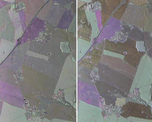
shows how it is possible to monitor temporal growth of crops using polarimetric radar data.
Figure 2. Two images taken by the C band DLR–SAR system (19 April and 24 May 2006),in Demmin, an agricultural site located in Mecklenburg–Vorpommern in North-East Germany.
Agriculture and Interferometry
Interferometry is also an important tool in monitoring plant growth. A study on the Âgrâ wheat fields in India (Srivastava et al. Citation2006) showed it is possible to determine the relationship between wheat height and image backscatter. When the stalks are high volume scattering dominates from the canopy and the correlation is weak. Wheat height has been calculated to within a few centimetres by using a straightforward linear relation with the image backscatter. L and C bands also provide interesting information related to biomass. L band is most sensitive to wide-leafed plant biomass, and C band to the small-leafed plants (Paloscia Citation2002).
In the field of interferometry, the ‘Rice Monitoring in China’ project is one of the most important projects to date. It was developed through collaboration between the ESA and the National Remote Sensing Center of China (NRSCC), and ended in 2006. Its goal was to develop a methodology to study and manage rice fields, especially as related to water management (the ASAR system of Envisat was used for this project).
Hydrology
Soil moisture can be estimated through analysis of SAR data owing to the relationship between moisture and the dielectric constant, when using centimetric electromagnetic waves. It has been shown that, for a given set of soil parameters (such as texture, roughness), there is a linear dependency (with a reliability of 80%-90%) between the radar backscatter and the volumetric moisture in the upper 2 to 5cm of the ground (Dobson and Ulaby Citation1986). But, this information may be masked by the surface roughness response that is the main component of the overall response, and which may be attenuated by vegetation. In order to minimise these effects, the use of incidence angles less than 30 degrees and C band data (Sokol et al. Citation2004) is recommended.
Polarimetric radar data can be used to study snow and to determine its type (Sokol et al. Citation2004). To do this, C band is used. For wet snow, the signature indicates a smooth surface (the pedestal height is low) and is quite independent from polarisation. For dry snow, the pedestal height is higher as the waves penetrate to the ground, which is coarser. In this case, the VV polarisation peaks indicating surface scattering. When the snow layer is thicker and has a nival coat, ice layers are developing inside it, and this causes changes to the polarimetric signature. In this case, the surface seems coarser, with a much higher pedestal height, and a significant scattering is produced using HH and VV polarisations.
Another application of polarimetric radar systems in the field of hydrology is wetland classification, using vegetation diversity (shape, size and repartition varieties, with a random distribution of trees among vertical plants, such as rushes). Vertical plants are identified by combining HH and VV polarisations, and vegetal or aquatic targets are detected through orthopolarisation (especially when their courses are winding).
Two projects, Aquifer and GlobWetland, deal with hydrology and use radar satellites. Aquifer aims to assist government organisations and international institutions in managing their ground water, especially in Africa, particularly when they are shared among several countries. Envisat (ASAR) is being used for this project. The GlobWetland project, which uses Envisat and Radarsat-1, aims to provide several national authorities with the capability of monitoring/controlling wetlands of their respective countries, and thus to help manage the soil/ground and water resources with respect to the Ramsar Convention on wetlands management and conservation.
Forestry
Radar imaging is a high-performing technology for studying the dynamics of forest ecosystems. As for both the polar regions, clouds often cover tropical forests and SAR systems are required to capture the necessary information from these areas.
Many structural parameters that characterise the forest canopy are closely related to ecosystem functions. These parameters include, for example, forest classification, detection of clear-cut or burned-out areas, extraction of biophysical data (including the ligneous biomass), tree density, height and diameter of trees, their age, foliar index and biomass, vegetative cycle, etc.
Polarimetric data provide unique information about the forest canopy, especially its architecture, through identification of the different scattering mechanisms. These mechanisms include direct scattering from branches (unique reflection or volume diffusion), from tree trunks (unique reflection), and from the ground (surface scattering). But, there is also scattering from ground and branches (double reflection), and from trunks and branches (double reflection). All these parameters are directly related to the type of forest.
Simulations on a hardwood forest using L band (Durden et al. Citation1989) showed that if the canopy density is very high, HH polarisation returns are quite similar to VV ones (VV being slightly lower). This suggests that, in this case, the main mechanism is branch-multiple scattering, with a slight double bounce component. The pedestal height is high, as expected in such a situation where the scattering mainly results from a depolarisation by the branches. When using the same canopy architecture, but reducing its density, the copolarised signature is a saddle-shaped one, which is typical of double bounce scattering (dihedral reflection). This is caused by trunk-ground reflections, related to a lower branch density. At the same time, there is less volume effect as the signal is less depolarised, and the pedestal height is low.
Other simulations, performed on a eucalyptus forest (Coops Citation2002), demonstrated the ability of SAR data to extract biomass information. In particular, it has been shown that there is a strong correlation between ‘P and C bands’ and ‘leaves and trunks’, and also between the ‘P and L band ratio’ and ‘leaves and branches’. P band is the most appropriate one for forestry biomass monitoring, as HV polarisation is strongly correlated with it (Castel Citation1998).
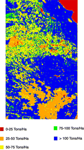
shows one result using radar data for forest biomass calculation.
Figure 3. Biomass calculated using SIR-C/X-SAR in Raco, Michigan.
Many approaches have been developed to characterise wooded areas and non-wooded areas (clear-cut areas), as described in Durden et al. (Citation1989), by using:
-
Pedestal height: very low in the case of a non-wooded areas;
-
VV and HH polarisation: VV is higher than HH one for non-wooded areas (surface reflection);
-
Co-polarised phase difference: this difference is lower for non-wooded areas (surface scattering).
Interferometry can also be used to improve forest classifications. By using the temporal decorrelation, (Wegmuller and Werner Citation1997) obtained very interesting results (90% of classifications were successful).
In conclusion, radar imaging makes it possible to study primary and secondary forests and their evolution. The ESA is launching a project, entitled BIOMASS. This project will use a P band SAR system to study the biomass spatial distribution on a global scale, and it will particularly focus on regions considered in critical condition.
Oceans
Several physical processes, natural or related to human activities, cause perturbations of the ocean surface, and can be studied using radar imagery. This includes atmospheric phenomena (convective cells, atmospheric fronts, gravity waves) as well as oceanic phenomena caused by currents (marine eddies, internal waves, water mass boundaries and surface gravity waves). It is possible to use these irregularities to extract information about surface winds, internal waves and currents.
Two approaches have been developed to study surface wind. The first is a direct one and takes advantage of changes in ocean surface roughness, as this parameter is directly related to speed and direction of the wind. There are several ways to establish the correlation between wind vector data and radar data, depending on the incident angle value. When this angle is low, the main mechanism is the Bragg diffusion process, as the main component of the signal is proportional to roughness, but there may be a saturation effect for some wind speed values. For intermediate incident angle values, models, which include many geophysical parameters, have been developed to evaluate surface winds (Shimada et al. Citation2003). For the latter approach, VV polarisation is used.
The second approach in studying surface wind uses the well-known Doppler effect. Ocean wave movements cause an image distortion in the azimuthal direction. One tries to establish the correlation between the two phenomena (distortions are proportional to ocean wave speed variance), and to use the result to estimate wind vector data. As a complement to either of these approaches, information can be obtained through C band HH and VV polarisations.
Ocean currents change the relative speeds between air and ocean surfaces, causing changes of its roughness. These perturbations can be detected by analysing radar images. In addition, these ocean currents are directly related to the movement of water masses that have different temperatures. These water masses change the temperature difference between water and the air, causing a ‘stress’ that is detectable in radar images (for detecting ocean currents, HH is the better polarisation). Finally, use of the Doppler effect, as mentioned above for surface wind detection, can provide a separation of the different components-those related to the wind, and those related to ocean currents. Usually, the signal in cross-polarised images is too weak, and does not provide any significant information about winds and waves.
Ship detection is another ocean application. Simple radar polarisation systems provide efficient ship detection so long as the most appropriate wavelength and a reliable system for automatic target detection are selected. Maximising the polarimetric contrast, as discussed above, facilitates this detection capability. However, without using this technique, one can conclude:
-
Cross-polarisations (HV and VH) are the most useful. HH polarisation (because of the entropy associated with this polarisation) and VV polarisation (because the scattering mechanism between the ship and the ocean is a double bounce);
-
VV polarisation may be useful for detecting ship wakes.
When there are very high winds, ships may be indistinguishable from water owing to surface roughness. But, if one can extract the wind parameters, one can separate the signal associated with surface coarseness from the signal enabling ship detection. This ship detection capability is very important for monitoring and control of maritime areas that have critical military or commercial interests (fishing areas, specific coastal jurisdictions).
Coastal areas
Coastal areas are fragile ecosystems that can be destabilised by human or natural activity (chemical discharge, urbanisation, tourism, sediment accumulation, etc.). Polarimetric SAR systems are an efficient tool for monitoring/controlling the evolution of such ecosystems, mainly through permanent programs of updating coastal maps and charts, seabed charting, and monitoring human and natural pertubations of the coastal environment.
Calm water acts as a specular reflector that returns a weak signal, unlike the earth that produces a more intense response. Under these conditions, charting the coastline is a straightforward problem, unlike the case when the water surface is modified by high winds. HV polarisation provides a solution to this problem through earth/water contrast enhancement. Coastal cartography is a crucial question as, in many cases, the charts are obsolete or do not exist, particularly in developing countries. This lack of cartographic information generates risks to coastal navigation. The COASTCHART project, supported by the ESA, which used ASAR data from Envisat, ended in 2006 with the production of coastal charts at scales from 1:50 000 to 1:15 000, and included the charting of much of the African coast (6000 km, from Senegal to Congo).
As mentioned earlier, in the case of coastal areas, the identification of scattering mechanisms using polarimetry, can be used to ‘classify’ the substrate:
-
Mud: the pedestal height is low; with a maximum in VV polarisation (surface reflection) and odd number of bounces (smoothed or slightly coarse surfaces);
-
Sands: the pedestal height is high; with a maximum in VV polarisation (surface reflection), and a main cross-polarised backscatter in C band (associated with volumetric and multiple scattering); it is also characterised by an odd number of reflections correlated to a combination of even and diffuse scattering;
-
Gravels: the pedestal height is high; with a maximum in VV polarisation (surface reflection), and a strong echo in HH polarisation (double reflection caused by small stones that act as corner reflectors).
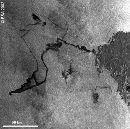
SAR systems are also used for identification and monitoring oil pollution, spills, and oil exploration. Oil slicks reduce ocean surface roughness and, as a consequence, the backscatter intensity is reduced. is an example of an oil spill in the ocean. The best conditions for oil slick detection occurs when there are moderate winds (3 m/s to 10 m/s), which produce waves from 30 cm to 2 m. VV polarisation is the most sensitive to wind variability, and thus aids in characterising oil slicks, although not noticeably. In addition to this information, knowing the wind speed may help to avoid false alarms.
Figure 4. Envisat (ASAR) image of oil pollution (shown in black) from the wreck of the tanker Prestige off the Spanish coast in November, 2002. (courtesy ESA)
The I-STOP monitoring program (Integrated Satellite Tracking of Pollution) is dedicated to identifying oil spills caused by marine transportation or offshore oil production. This project uses Radarsat-1 images to direct aircraft toward locations where oil spills have been identified. The program is used for surveillance of waters under Canadian jurisdiction and involves the coordination of several Departments, federal organisations and private companies. It involves the Canadian Space Agency, Transport Canada, and the Canadian Coast Guard. Recently (March 2007), the Rowan Gorilla VI oil rig paid a CAN$70,000 fine because it illegally discharged polluting material into Canadian waters.
Coastal area bathymetry can also be obtained from radar imagery when then depth is less than 30 m. The radar signature is related to current changes that modulate capillary waves. A study in the Netherlands showed that bathymetric measurements obtained in this manner are within a 30 cm level of accuracy (Hasselmans et al. Citation1997). An extension of this same study of the wind detection in relation to the ocean-atmosphere interaction in coastal areas could be developed to optimise establishment of wind ‘farms’.
Natural disasters
SAR systems are an efficient way of providing information support for planning delivery of humanitarian assistance when natural disasters occur. While there are several types of disasters, in this section, the focus is on flood management with some comments on landslides.
Several approaches may be applied depending on the areas of concern, as the data collected is different for open areas, forest areas and urban areas:
-
Open areas: the water surface is smooth and thus reacts as a specular reflector, which produces very weak echoes. Comparatively, the surrounding ground is rougher and thus produces a higher signal return. SAR images of floods in open areas appear as very dark zones, which are flooded ground, and brighter zones, which are non-flooded (Henderson Citation1995). Because of this property, a threshold procedure is sufficient, in most cases, to detect flooded areas (Brivio et al. Citation2002, Malnes et al. Citation2002). The contrast between the two zones depends on the polarisation and on the incident angle. VV polarisation and shallow incident angles reduce the contrast. A solution to this problem has been proposed by (Solb⊘ et al. Citation2004), where a ‘maximum likelihood criterion’ is applied after a preliminary threshold, so that the analysis is almost independent of the incident angle (Ahtonen et al. Citation2004). is a composite of two radar images of a typical flood area illustrating this approach to flood monitoring.
-
Forested areas: long radar waves can penetrate the forest canopy, thus the flooded areas will generate significant signal returns, owing to the double reflection ‘trunk/flooded ground’. In these cases it is usually better to use interferometry, where the flooded areas can be identified by comparing them to a reference scene (Mouginis-Mark et al. Citation1984, Kandus et al. Citation2001, Townsend Citation2001 and Citation2002). Other methods use active contours (snakes) (Horritt and Mason Citation2001, Horritt et al. Citation2003), but their initialisation is quite difficult. Because of the forest canopy, it is impossible to use remote sensing systems other than SAR to characterise flooded zones in forested areas (Bourgeau-Chavez et al. Citation2001).
-
Urban areas: reflected signals are significant because of the many corner reflectors that are unaffected by the flooding. In these cases, interferometry, based on temporal decorrelation, is used to identify flooded areas (Dellepiane et al. Citation2000, Stabel and Löffler Citation2003). Buildings, which remain at exactly the same locations, will produce a maximum correlation, while the water surface, which moves continuously, will produce a correlation equal to zero. This approach can also be used in the two other cases of flooding discussed above.
Figure 5. Flooding in Bangladesh and parts of India brought on by two weeks of persistent rain.
Using SAR systems, in some cases it is possible to detect small variations in the terrain using the ‘persistent scatterer’ technique and differential interferometry (Colesanti et al. Citation2003b, Delacourt et al. Citation2003, Hilley et al. Citation2004). This technique consists of reviewing a large number of images (from archives) to automatically identify objects that are very stable in space and time (identification being possible because of their high correlation). These objects are used to correct the bias introduced by the satellite orbit imprecision, and also to correct the phase delay that is produced by varying atmospheric water content.
‘Global Monitoring for Environment and Security’ (GMES), including Sentinel-1 for SAR imaging, is a program initiated by the ESA and the European Community. The goal of this program is to centralise and rationalise European activities in Earth Observation, in order to access these data very quickly if there is an urgent requirement. ‘Sentinel Asia’ is a project proposed in 2004 by the Asia-Pacific Space Agency. This project is similar to GMES, but it is dedicated to Asian countries, and uses the Japanese satellite Alos (PALSAR).
Topography
The only technique used for topography is differential interferometry. It can be applied to seismology, cartography in mountainous areas, vulcanology, and subsidence studies.
Work in seismology has developed in several directions using differential interferometry. These deal with co-seismic deformation studies (i.e. those directly related to the main earth tremor) (Reilinger et al. Citation2000, Pedersen et al. Citation2001), post-seismic deformation analysis (after earthquakes) (Jónsson et al. Citation2003), tectonic event observation (i.e. slippage along the rifts that do not generate seismic waves) (Rosen et al. Citation1998), and inter-seismic monitoring (Wright et al. Citation2001, Colesanti et al. Citation2003a) (i.e. between two earthquakes).
The following is an example of the use of SAR images in understanding the movement of seismic activity (Bawden et al. Citation2003). A magnitude 6.7 earthquake occurred in October, 2002 at Nenna Mountain (Alaska). Radar images showed it resulted in new deformation far away from the epicentre of the quake. Interferograms suggested that geological constraints had ‘migrated’ to another part of the same scene. Another earthquake, magnitude 7.9, occurred two weeks later in the location identified by interferometry.
Geologists theorise that seismically-produced deformations can be located far from the quake epicentre, as the ground offsets the first tremor. This hypothesis led to the use of SAR systems for studying rifts, in order to detect distant movement and to attempt to predict other quakes. As the technology stands at present, only SAR systems can be used for such applications, as the movement involved in these processes may be only 1mm per year (for aseismic and inter-seismic cases). It is interesting to note that differential interferometry enables the detection of radial deformation (i.e. in the radar look direction). Because of the incident angles, radar is more sensitive to vertical rather than horizontal deformation, which does not allow reliable three-dimensional studies. Solutions to this three-dimensional analysis problem have been found through the use of ascending and descending orbits for data capture (Fialko and Simons Citation2001), or by using several interferograms (Wright et al. Citation2004).
Mountain-area cartography (with Digital Terrain Elevation) also takes advantage of differential interferometry, with the use of ascending and descending orbits (or image capture ‘from left’ and ‘from right’), of several baselines, of various viewing angles, and of frequencies (Eineder Citation2005). A variety of parameters are used, as the respective target and radar positions (slant range) induce distortions in the mountainous regions, with objects on the mountains being closer to the radar. Consequently, the mountainside facing the radar will appear contracted and its density of energy will be higher (‘highlighting’ phenomenon) as the illuminated surface will be significantly smaller, and the opposite for the opposite mountainsides (‘lowlighting’ phenomenon). In some extreme cases (e.g. for a peak or for the top of a cliff), it is even possible that a high point will seem to be closer to the radar than another point whose ground position is between the two.
Differential interferometry also provides important information for vulcanology studies. Compared to other means of surveillance (e.g. GPS beacon networks), it can be used for regional studies, such as volcanic upheaval (caused by rising magma rising or increased gas pressure from below) and volcanic subsidence (caused by surface lava accumulation, depressurisation during eruptions, or hydrothermal cooling) (Amelung et al. Citation2000, Lu et al. Citation2000, Massonnet and Sigmundsson Citation2000, Salvi et al. Citation2004). Vulcanologists have been very surprised that these phenomena could be monitored, even for very long-term inactive volcanoes. GlobVolcano is a project of the ESA to monitor volcanic risk using many satellites with SAR systems, in particular Envisat (ASAR) and Radarsat-1.
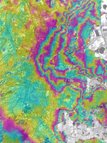
Subsidence and upheaval phenomena may be a result of fluid extraction, construction, or geothermal activity, as mentioned in many publications (Ulaby et al. Citation1987, Cloude and Pottier Citation1997, McNairn et al. Citation2002a and 2004). Studies on such phenomena are mainly concerned with urban areas, for which differential interferometry is a very efficient technique, as towns have very few temporal decorrelations, even over long periods. is typical, and shows the subsidence of Mexico City over six months in 1996. These studies may be extended beyond urban areas (into other neighbourhoods and industrial areas) by using the ‘persistent scatterer’ technique.
Figure 6. Displacement map of Mexico City metropolitan area over six months in 1996.
Seasonal ground displacements owing to underground fluid flow variations have been observed in the Los Angeles area (Bawden et al. Citation2001). This information is very useful in correcting results obtained from seismic studies or unknown rift detection.
SAR systems can also be used for monitoring construction deformation, as in the cases of buildings, bridges, dams and pipelines. The monitored structure may naturally reflect radar waves, but this is not usually the case. Two techniques are then used to provide an interaction with the radar system:
-
A set of hollow tetrahedrons are ‘hung’ on the structure to produce a double reflection. This technique is called the ‘Corner Reflector Interferometry’;
-
Active electronic boxes, called transponders, are also ‘hung’ on the structure, and emit a signal that can be interpreted by SAR systems. This technique is called the ‘Compact Active Transponder Interferometry’;
In both cases, small objects are detected and produce significant echoes. These configurations enable the analysis of very small deformations.
One example of successful deformation detection is the McMicken Bridge in Arizona. It is a 15-km-long structure, which subsided more than 1.5 m since its construction in 1955. Radar imaging (Ralph et al. Citation2004) confirmed the subsidence, and thus engineers were able to use the data to analyse potential structure weaknesses.
A global project-the PIPEMON Project-was created by the ESA in the framework of the ‘ Earth Observation Market Development ’ program (EOMD). Its goal is to provide services for the study of infrastructure deformation using SAR systems.
Challenge and perspectives
Many applications related to Digital Earth concepts can benefit by using SAR systems. This paper outlined where this technology can provide unique support for these applications, and some important projects that promote (or have promoted) their use. In this light, it is interesting to review some SAR limitations, and offer some challenges. Some possible directions for future development and improvements in the field include:
-
Low frequency microwaves, such as L and P band, penetrate the forest canopy and interact with structural elements (leaves, branches, and trunks). Higher frequencies, such as C band, interact with the upper part of the canopy. Thus, high frequency sensors have a limited utility for measuring the dry biomass variations, but it should be possible to use L and P band information for such analyses.
-
Coastal wind studies using SAR imagery is generally not reliable enough, because of the interaction of bathymetric, internal waves and tide effects (Christiansen and Hasager Citation2006). It would be useful to improve on existing current-interaction models.
-
SAR systems have evolved toward fully polarimetric radar systems. However, it would be very useful to have information from different bands over the same area, for the same application. Although some systems already have two bands, the next generations of SAR systems should be fully polarimetric and multifrequency.
-
Radar images are not intuitively understandable. In addition, they depend on incident angles, coarseness criteria, winds, and knowledge of precipitation before the acquisition. Optical images, on the other hand, are easily understandable. Improved data fusion between SAR and optical imagery should be developed to most efficiently visualise information that can be extracted from SAR images.
-
Several challenges also concern interferometry (Ge et al. Citation2006). A phase discontinuity problem needs to be solved for differential interferograms when the variations are too large in relation to the phase definition (2p module). A priority should also be to reduce the noise in these images without modifying information on various types of deformation.
Notes on contributors
Christophe Palmann received a ScM degree in computer science from the University of Marseilles, France, in 2007. He is currently preparing his PhD degree under the supervision of Jean Sequeira and Sébastien Mavromatis. His research interests lie in registration and fusion of multisensor images.
Sé bastien Mavromatis received his PhD degree in Computer Science from the University of Marseilles, France, in 2001. He is currently an associate professor at the University of Marseilles (ESIL). He is also a member of the Laboratory of Information Science and Systems (LSIS). His research interests include Remote Sensing, Three-dimensional Scene Reconstruction and Virtual Reality.
Mario Hernandez is of Mexican nationality. In 1994 he joined the United Nations Environment Programme on the use of remote sensing to assist countries in their associated State of the Environment reporting. Since 2001 Mr. Mario Hernandez is working at the United Nations Educational Scientific and Cultural Organization (UNESCO). He is coordinating an important partnership of space agencies, space research institutions and universities that are assisting UNESCO in the monitoring of the famous World Heritage sites.
Jean Sequeira has been a Full Professor at the University of Marseilles since 1991. In 1994, he created a research group on ‘Image Analysis and Computer Graphics’. He is now a Vice-Director of the LSIS. He published more than 90 papers, 27 of them in Journals and 40 in International Conferences.
Brian Brisco has been involved in remote sensing since 1975. He worked for Intera from 1989 until 1997 as a research associate after completion of an NSERC post-doctoral fellowship served at the Canada Centre for Remote Sensing (CCRS). From 1997 to 2006 he has worked for Noetix Research Inc. where he was the Director of Research and Applications Development. Brian is currently a Research Scientist at CCRS.
Acknowledgements
We would like to thank the reviewers for their valuable suggestions.
Related Research Data
References
- Ahtonen , P. , et al. , 2004 . SAR and optical based algorithms for discrimination of water bodies (Technical report of FloodMan Project) [online]. NorutAS (project coordinator) . Available from: http://projects.itek.norut.no/floodman/Deliverables/D1_2_Report.doc [Accessed 04 October 2007] .
- Amelung , F. 2000 . Widespread uplift and ‘trapdoor’ faulting on Galápagos volcanoes observed with radar interferometry . Nature , 407 : 993 – 996 .
- Bawden , G.W. 2001 . Tectonic contraction across Los Angeles after removal of groundwater pumping effects . Nature , 412 : 812 – 815 .
- Bawden G.W. , et al. , 2003 . Measuring human induced land subsidence from space , U.S. geological survey fact sheet , 069–03 .
- Bourgeau-Chavez , L.L. 2001 . Analysis of space-borne SAR data for wetland mapping in Virginia riparian ecosystems . International Journal of Remote Sensing , 22 ( 18 ) : 3665 – 3687 .
- Brivio , P.A. 2002 . Integration of remote sensing data and GIS for accurate mapping of flooded areas . International Journal of Remote Sensing , 23 ( 3 ) : 429 – 441 .
- Castel , T. , 1998 . Retrieval of forest biomass from spaceborne synthetic aperture radar data: on the coupling of an architectural plants model with an electromagnetic model . Thesis (PhD). ENGREF .
- Christiansen , M.B. and Hasager , C.B. 2006 . Wind energy applications of synthetic aperture radar . 14th Conference on Interaction of the Sea and Atmosphere . Atlanta, Georgia (USA). 29 January–2 February 2006 .
- Cloude , S.R. and Pottier , E. 1997 . An entropy based classification scheme for land applications of polarimetric SAR . IEEE Transactions Geoscience and Remote Sensing , 35 ( 1 ) : 68 – 78 .
- Colesanti , C. 2003a . SAR monitoring of progressive and seasonal ground deformation using the Permanent Scatterers Technique . IEEE Transactions on Geoscience and Remote Sensing , 41 ( 7 ) : 1685 – 1701 .
- Colesanti , C. 2003b . Monitoring landslides and tectonic motions with the permanent scatterers technique . Engineering Geology , 68 : 3 – 14 .
- Coops , N.C. 2002 . Eucalypt forest structure and synthetic aperture radar backscatter: a theoretical analysis . Trees – structure and function , 16 ( 1 ) : 28 – 46 .
- Delacourt , C. , et al. , 2003 . Potential and limitation of ERS-Differential SAR Interferometry for landslide studies in the French Alps and Pyrenees . FRINGE 2003 workshop (ESA SP-550) . Frascati, Italy. 1–5 December 2003 .
- Dellepiane , S. 2000 . Improvements in flood monitoring by means of interferometric coherence . Proceedings of the Society of Photographic Instrumentation Engineers , 4173 : 219 – 229 .
- Dobson , M.C. and Ulaby , F.T. 1986 . Active microwave soil moisture research . IEEE Transactions on Geoscience and Remote Sensing , 24 ( 1 ) : 23 – 36 .
- Durden , S.L. 1989 . Modeling and observation of the radar polarization signature of forested areas . IEEE Transactions on Geoscience and Remote Sensing , 27 ( 3 ) : 290 – 301 .
- Eineder , M. , 2005 . Interferometric DEM Reconstruction of Alpine Areas – Experiences with SRTM Data and Improved Strategies for Future Missions . European Association Of Remote Sensing Laboratories Symposium . Porto, Portugal. 7–9 June 2005 .
- Fialko , Y. and Simons , M. 2001 . The complete (3-D) surface displacement field in the epicentral area of the 1999 Mw 7.1 Hector Mine earthquake, California, from space geodetic observation . Geophysical Research Letters , 28 ( 16 ) : 3063 – 3066 .
- Ge , L. , Chang , H.C. and Rizos , C. 2006 . Monitoring land surface subsidence using radar interferometry: the challenges . Shaping the Change 23rd FIG Congress . Munich, Germany. 8–13 October .
- Giraldez , A.E. , 2003 . Saocom – 1 Argentina L band SAR mission overview . 2nd Workshop on Coastal and Marine Applications of SAR . Salvard, Norway. 8–12 September .
- Goldstein , R.M. 1993 . Satellite radar interferometry for monitoring ice sheet motion: application to an Antarctic ice stream . Science , 262 : 1525 – 1530 .
- Henderson , F.M. 1995 . Environmental factors and the detection of open surface water areas with X-band radar imagery . International Journal of Remote Sensing , 16 ( 13 ) : 2423 – 2437 .
- Hasselmans , G. , Calkoen , C. and Wensink , H. 1997 . Mapping of seabed topography to and from SAR . 3rd ERS Symposium Space at the Service of our Environment (ESA SP-414) . Florence, Italy. 14–21 March .
- Hilley , G.E. , et al. , 2004 . Dynamics of slow-moving landslides from permanent scatterer analysis . Science , 304 , 1952 – 1955 .
- Horritt , M.S. , Mason , D.C. and Luckman , A.J. 2001 . Flood boundary delineation from synthetic aperture radar imagery using a statistical active contour model . International Journal of Remote Sensing , 22 ( 13 ) : 2489 – 2507 .
- Horritt , M.S. , Mason , D.C. , Cobby , D.M. , Davenport , I.J. and Bates , P. 2003 . Waterline mapping in flooded vegetation from airborne SAR imagery . Remote Sensing of Environment , 85 : 271 – 281 .
- Jónsson , S. 2003 . Postearthquake ground movements correlated to pore-pressure transients . Nature , 424 : 179 – 183 .
- Joughin , I.R. , Winebrenner , D.P. and Fahnestock , M.A. 1995 . Observations of ice-sheet motion in Greenland using satellite radar interferometry . Geophysical Research Letters , 22 ( 5 ) : 571 – 574 .
- Joughin , I. 1996 . Measurement of ice-sheet topography using satellite radar interferometry . Journal of Glaciology , 42 ( 140 ) : 10 – 22 .
- Joughin , I.R. , Kwok , R. and Fahnestock , M.A. 1998 . Interferometric estimation of three-dimensional ice-flow using ascending and descending passes . IEEE Transactions on geoscience and remote sensing , 36 ( 1 ) : 25 – 37 .
- Joughin , I. 1999 . Iceflow of Humboldt, Petermann, and Ryder Gletscher, northern Greenland . Journal of glaciology , 45 ( 150 ) : 231 – 241 .
- Kandus , P. 2001 . Influence of flood conditions and vegetation status on the radar backscatter of wetland ecosystems . Canadian Journal of Remote Sensing , 27 ( 6 ) : 651 – 662 .
- Kwok , R. and Fahnestock , M.A. 1996 . Ice sheet motion and topography from radar interferometry . IEEE Transactions on Geoscience and Remote Sensing , 34 ( 1 ) : 189 – 200 .
- Lu , Z. 2000 . Synthetic aperture radar interferometry of Okmok volcano, Alaska: Radar observations . Journal of Geophysical Research , 105 ( B5 ) : 10791 – 10806 .
- Malnes , E. , Guneriussen , T. , and H⊘gda , K.A. , 2002 . Mapping of flood-area by Radarsat in Vannsj⊘, Norway . 29th International Symposium on Remote Sensing of Environment . Buenos Aires, Argentina. 8–12 April .
- Massonnet , D. and Sigmundsson , F. 2000 . Remote sensing of volcano deformation by radar interferometry from various satellites . Geophysical Monographs , 116 : 207 – 221 .
- Mcnairn , H. 2002a . The effect of crop residue characteristics on polarimetric radar response . Remote Sensing of Environment , 80 : 309 – 320 .
- Mcnairn , H. , Hochheim , K. and Rabe , N. 2004 . Applying polarimetric radar imagery for mapping the productivity of wheat crops . Canadian Journal of Remote Sensing , 30 ( 3 ) : 517 – 524 .
- Misra , T. , Rana , S.S. and Shankara , K.N. 2005 . Synthetic aperture radar payload of radar imaging satellite (RISAT) of ISRO . General Assembly of the International Union of Radio Science . New Delhi, India. 21–29 October .
- Mohr , J.J. , Reeh , N. and Madsen , S.N. 1998 . Three-dimensional glacial flow and surface elevation measured with radar interferometry . Nature , 391 : 273 – 276 .
- Mouginis-Mark , P.J. , Gaddis , L.R. and Ferall , C. , 1984 . The Mississippi river delta: the monitoring of costal processes with spaceborne and airborne radar and multispectral experiments . International Symposium on Remote Sensing of the Environment (thIrd Thematic Conference: Remote Sensing for Exploration Geology) . Colorado Springs, Colorado (USA). April 1984 .
- Onstott , R.G. and Gaboury , S.H. 1989 . Polarimetric radar measurements of artificial sea ice . Proceedings of International Geoscience and Remote Sensing Symposium , 3 : 1938 – 1941 .
- Paloscia , S. 2002 . A summary of experimental results to assess the contribution of SAR for mapping vegetation biomass and soil moisture . Canadian Journal of Remote Sensing , 28 ( 2 ) : 246 – 261 .
- Pedersen , R. 2001 . Coseismic interferograms of two Ms = 6.6 earthquakes in the South Iceland Seismic Zone, June 2000 . Geophysical Research Letters , 28 ( 17 ) : 3341 – 3344 .
- Ralph , E. et al. , 2004 . Application of synthetic aperture radar interferometry (InSAR) in defining mine-related ground deformation and subsidence hazards . Interstate Technical Group on Abandoned Underground Mines 5th Biennial Workshop . Tucson, Arizona (USA). 21–23 April .
- Reilinger , R.E. 2000 . Coseismic and postseismic fault slip for the 17 August 1999, M = 7.5, Izmit, Turkey earthquake . Science , 289 ( 5484 ) : 1519 – 1524 .
- Rignot , E.J. 1997 . North and northeast Greenland ice discharges from radar interferometry . Science , 276 : 934 – 937 .
- Rosen , P. 1998 . Aseismic creep along the San Andreas fault northwest of Parkfield, CA measured by radar interferometry . Geophysical Research Letters , 25 ( 6 ) : 825 – 828 .
- Salvi , S. 2004 . Inflation rate of the Colli Albani volcanic complex retrieved by the permanent scatterers SAR interferometry technique . Geophysical Research Letters , 31 ( 12 ) : 12606 – 12610 .
- Scheuchl , B. , et al. 2001a . H/A/alpha-based Classification of Sea Ice Using SAR Polarimetry . 23rd Canadian Symposium on Remote sensIng . Quebec City, Canada. 21–24 August .
- Scheuchl , B. , et al. , 2001c . Automated sea ice classification using spaceborne polarimetric SAR data . 23rd Canadian Symposium on Remote Sensing . Quebec City, Canada. 21–24 August .
- Scheuchl , B. and Cumming , I.G. 2002a . Potential of radarsat-2 for sea ice classification . Proceedings of International Geoscience and Remote Sensing Symposium , 4 : 2185 – 2187 .
- Schroder , R. 2005 . MAPSAR: a small L-band SAR mission for land observation . Acta Astronautica , 56 ( 1–2 ) : 35 – 43 .
- Shimada , T. , Kawamra , H. and Shimada , M. 2003 . An L-band geophysical mode function for SAR wind retrieval using JERS-1 SAR . IEEE Transactions of Geoscience and Remote Sensing , 41 ( 3 ) : 518 – 531 .
- Sokol , J. , Mcnairm , H. and Pultz , T.J. 2004 . Case studies demonstrating hydrological applications of C-band multi–polarized and polarimetric SAR . Canadian Journal of Remote Sensing , 30 ( 3 ) : 470 – 483 .
- Solb⊘ , S. 2004 . Mapping of flooding in the Alessandria area with ERS . Proceedings of International Geoscience and Remote Sensing Symposium , 7 : 4689 – 4692 .
- Stabel , E. and Löffler , E. , 2003 . Optimised mapping of flood extent and floodplain structures by radar EO methods . FRINGE 2003 workshop (ESA SP–550) . Frascati, Italy. 1–5 December .
- Srivastava , H.S. , Patel , P. and Navalgund , R.R. 2006 . Application potentials of synthetic aperture radar interferometry for land-cover mapping and crop-height estimation . Current science , 91 ( 6 ) : 783 – 788 .
- Townsend , P.A. 2001 . Mapping seasonal flooding in forested wetlands using multi-temporal Radarsat SAR . Photogrammetric Engineering Remote Sensing , 67 ( 7 ) : 857 – 864 .
- Townsend , P.A. 2002 . Relationships between forest structure and the detection of flood inundation in forest wetlands using C-band SAR . International Journal of Remote Sensing , 23 ( 3 ) : 443 – 460 .
- Ulaby , F.T. 1987 . Senior T.B.A. Relating polarization phase difference of SAR signals to scene properties . IEEE Transactions on Geoscience and Remote Sensing , 25 ( 1 ) : 83 – 92 .
- Van Zyl , J.J. 1997 . Overview of SAR polarimetry and interferometry . Proceedings of the Society of Photographic Instrumentation Engineers , 3120 : 16 – 27 .
- Wegmuller , U. and Werner , C. 1997 . Retrieval of vegetation parameters with SAR interferometry . IEEE Transactions of Geoscience and Remote Sensing , 35 ( 1 ) : 18 – 24 .
- Wright , T. , Parsons , B. and Fielding , E. 2001 . Measurement of interseismic strain accumulation across the North Anatolian Fault by satellite radar interferometry . Geophysical Research Letters , 28 ( 10 ) : 2117 – 2120 .
- Wright , T.J. , Parsons , B.E. and Lu , Z. 2004 . Toward mapping surface deformation in three dimensions using InSAR . Geophysical Research Letters , 31 ( 1 ) : L01607