Abstract
After the set-up of a spatial data infrastructure (SDI) and a national information infrastructure (NII) in many countries, the provision of geo-services became one of the most important and attractive tasks. With the integration of global positioning system (GPS), geographic information system (GIS) and remote sensing (RS), we can, in principle, answer any geo-spatial related question: when and where what object has which changes? An intelligent geo-service agent could provide end-users with the most necessary information in the shortest time and at the lowest cost. Unfortunately there is still a long way to go to achieve such goals. The central component in such geo-services is the integration of the spatial information system with a computing grid via wire- and wireless communication networks. This paper will mainly discuss the grid technology and its integration with spatial information technology, expounding potential problems and possible resolutions. A novel categorising of information grids in the context of geo-spatial information is proposed: generalised and specialised spatial information grids.
1. Introduction to geo-services
Much progress is being made in the fields of geo-spatial data acquisition and utilisation. However, in many cases their spatial data and information are not being fully utilised, partially owing to the fact that they are acquired and managed by independent public sectors, which provide individual services to particular users. The importance of spatial data infrastructure (SDI) information sharing across different organisations has been recognised by both governmental agents and private sectors, but effective approaches to mine adequate and useful information are still lacking.The backbone characteristics of geo-services aim at providing basic services to those who need them most. These end-users may distribute over different public sectors in different regions, and in some cases they may distribute globally, such as the member countries of CEOS. Vögele et al. (Citation2003) summarised the following four types of basic geo-services in the context of the GeoShare Project carried out by the United Kingdom, Germany, Norway and the Netherlands:
Web Map Services (WMS): a Web Map Service produces map renderings of geo-referenced data. It is important to note that a ‘map’ in WMS is simply a visual representation of geo-data that does not contain the data itself. A map may be rendered by WMS in raster format or as vector-based graphical elements in Scalable Vector Graphics (SVG) format. The Web Map Services Specification is a specification approved by the Open GIS Consortium (OGC).
Web Feature Services (WFS): a Web Feature Service provides access to geo-spatial data stored in geo-databases through stateless HTTP requests. The results of such requests are returned in GML format, an XML-based geo-spatial vector data exchange format. Like WMS, WFS implements an approved OGC implementation specification.
Geo-databases: the related geo-data has to be stored in geo-databases for meaningful WFS and WMS integration. Currently available geo-databases overcome the separation of geometric and attribute data and the object-relational schema used to model is much closer to the OGC concept of geographic features.
The Intelligent Category Services (ICS): it plays an important and central role in the GeoShare Network. It is used to manage the metadata descriptions of services, datasets and data collections in the network. Thus ICS will provide a detailed inventory of all registered resources, and queries to ICS are the basis for the retrieval and selection of task-specific data and services.
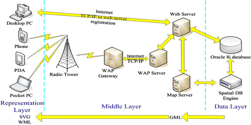
Besides web services there are many tools for Location-Based Services (LBS) and Mobile Location Service (MLS) through mobile communication networks. shows their configuration and several application interfaces.
Figure 1. System configuration of LBS and MLS.
In order to meet the basic prerequisites of the above mentioned geo-services, at least the following problems need to be solved:
-
The mechanism and approach with which intelligent services are provided, including the modeling of intelligent services workflow, tasks allocation, intelligent search, and system structure of the intelligent services platform.
-
The standards and interoperability of spatial information services. With such standards, interoperability across information boundaries becomes possible.
-
The semantic model of spatial information services. This includes an ontology-based semantic model and a spatial information service mode.
-
The implementation of spatial information services on different terminals, such as notebook computers, mobile phones, palm computers, TV sets, telephones, desktop computers, etc.
The central component in such geo-services is the integration of the spatial information system with computer networks. Owing to the success of information grids, they have been the backbone technique in the third generation of the internet. A spatial information grid aims at solving the above listed problems by the integration of grid technology and spatial information technology. It is believed to be the main trend in spatial information science for the next 20 years. The Global Earth Observation System of Systems (GEOSS) 10 Year Implementation Plan passed by the summit of Ministers from more than 50 countries and organised by Group on Earth Observations (GEO) is the prelude of such a trend (GEOSS Citation2005).
The key issue in such geo-services is the automatic and real time transformation from sensor web through information extraction and knowledge discovery to intelligent service in order to provide the most necessary information to different end-users in the shortest time and at the lowest cost.
This paper will mainly discuss the grid technology and its integration with spatial information technology, expounding potential problems and possible resolutions. A novel categorising of information grids in the context of geo-spatial information is proposed: generalised and specialised spatial information grids.
2. Grid technology: the third surge of the internet
Grid technology has emerged as an important new field, which is distinguished from conventional distributed computing by its focus on large-scale resource sharing, innovative applications, and performance orientation in some cases (Foster and Kesselman Citation1999, Foster et al. Citation2001).
Three hierarchies can be defined in grid technology: the computing grid, the information grid, and the knowledge grid (Li Citation2001). The computing grid is the fundamental layer, providing infrastructure to higher levels, namely to the information grid and knowledge grid. The information grid will provide end-users with an intelligent processing platform in order to eliminate isolated information islands, so that users can distribute, process, and acquire information easily. The knowledge grid will provide end-users with an intelligent process platform in order to eliminate isolated knowledge islands, so that users can distribute, process, and acquire knowledge easily.
Grid computing is a virtual and high-performance computation environment achieved by connecting various computers (include workstations), databases, mass storage and peripheral equipment that are distributed in geographically different regions. Its applications include distributed computing, high throughput computing, collaboration engineering, and database browsing. It can be defined as a ‘seamless integration and collaborated computing environment’ across a wide region.
Information grid provides an intelligent data processing and information extraction platform to end users based on currently available network infrastructures, protocols, web and database technology. Its object is to establish a new generation internet-based information processing platform and software infrastructure, which is built above operating (OS) and the web. Within such a platform, information processing is distributed, collaborated, and intelligent. Users can access all information employing only one unified interface. The ultimate goal of information grid is to service on demand and to service by one-click-is-enough. The system structure, information representation, meta-information, information connectivity, and consistency, and information security, etc., are currently the hot research topics of information grid.
Owing to its potential innovative applications, research on grid technology is receiving much attention. Industry circles, as well as governmental divisions and academic communities, are all paying much attention to it. Open Grid Service Architecture (OGSA) has devised service protocols and standards (OGSA Citation2008). An independent non-profit organisation, Global Grid Forum (GGF), has been established for related research work (GGF Citation2008).
In summary, grid is a new technology based on the internet, which merges high-speed internet, computers, large-scale databases, sensors, and remote equipment into one computing environment. It provides researchers as well as common users with more resources, functionalities, and services. People use the internet for receiving and sending emails, web browsing, while grid gives people more powerful functions for sharing computing resources, storing resources, data resources, information resources, knowledge resources, expertise resources, and any other type of resources (Foster and Kesselman Citation1999).
Grid is a type of infrastructure with resources sharing as its backbone characteristic. Grid computing implements resource sharing and problem solving collaboratively among many virtual organisations. Grid computing is a new type of software structure, which organises many low cost storage modules and servers into a virtual computation environment, and uses these resources effectively and transparently. Any node in the grid can share services such as data storage, computation, databases, and location based services. Presently, grid computing is applied to many fields such as simulation, medicine, geo-sciences, bio-science and the military and has achieved results much better than conventional distributed technology.
3. Generalised spatial information grid
3.1 Background
Humans live in the interaction of four spheres, namely the lithosphere, hydrosphere, atmosphere and biosphere, ranging from space to underground and undersea. More than 80% of natural and social phenomena are closely related to spatial location. In order to acquire temporally changing geographic information with information technology, communication technology, space-borne and air-borne remote sensing and satellite navigation positioning systems have been developed rapidly since the 1970s, which at last have led to a new subject called geo-spatial information science (i.e. geomatics or geoinformatics) with global navigation satellite system (GNSS), geographic information system (GIS) and remote sensing (RS) as its central components.
According to the International Organization for Standardization (ISO) definition (Li and Guan Citation2000), geomatics is ‘a discipline related to spatial data acquiring, measuring, analysing, storing, managing, displaying and applying’. It belongs to information science and technology.
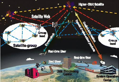
(Zhou and Kafatos Citation2002) shows the airspace-borne spatial information systems. It is obvious that these systems can theoretically answer what changes (what) of which objects (which) have taken place at what time (when) and what place (where), 4W. However, the state-of-the-art of spatial information systems cannot meet the requirement of seamless integration and collaborative computing that grid technology requires, so it cannot answer the above 4W yet. The main problems are the following:
-
The flow of data processing–information extraction–knowledge discovery–application services is serial and separate. Data are acquired in point mode or area mode, none of which has the ability of on-orbit processing or real-time computing. Information processing is carried out in a single computer with human-machine interaction. Data mining and knowledge discovery are still in a naive stage. Application services are isolated, lacking in intelligent service in a network environment.
-
The level of sharing and utilising satellite resources is very low. There is still much difficulty in intelligent data processing, information extraction, and knowledge discovery, both in theory and with the algorithms, leading to huge volumes of data but a lack of information.
-
Earth observation systems are usually isolated, lacking in multi-platform, multi-sensor, multi-resolution and multi-temporal integrated systems.
-
Lack of an application oriented grid system with real time satellite deployment, data integration, automatic information extraction and intelligent services. The integration of the geo-spatial information system and the communication system is not sufficiently advanced.
Figure 2. Aerospace-borne spatial information systems (Zhou and Kafatos 2002).
In order to solve these problems, the integration of grid technology with geo-spatial information system is presented as the salient challenge, which leads to the generation of the generalised spatial information grid.
3.2 Definition and tasks of the generalised spatial information grid
We give the following definition for the generalised spatial information grid in the context of grid technology and geo-spatial information systems:
A generalised spatial information grid is a kind of real time/near real time spatial information system supported by an information grid. It runs in the environment of an information grid with an integrated mode of data acquisition (from space-borne, air-borne and ground-based sensors), information processing, knowledge discovery, and intelligent geo-services.
To establish such a grid, we face the following tasks:
-
All weather, all time, and all aspect spatial data acquisition by resorting to space-borne, air-borne, and ground-based sensors.
-
Seamless bridge from sensors to application service by resorting to an integrated information grid made up of satellite communications, data relay networks, and ground-based wire and wireless computer communication networks.
-
Implementation of grid computing quantitatively, automatically, intelligently and in real time in the generalised spatial information grid, extracting information and knowledge from data.
-
Intelligent services to any end user, providing the most useful information to most eagerly awaiting users with the fastest speed.
3.3 Basic components of a generalised spatial information grid
To accomplish the tasks mentioned above, a generalised spatial information grid needs at least the following components:
(i) Smart sensor web
Current sensors are specific equipment for data acquisition, and usually task-specified. The raw data acquired are transferred to ground receiving stations, processed by a specific software system, and then the information required by the end users can be retrieved. Such a workflow is composed of separate processing units and includes many human-machine interactions. Real time processing is impossible in such a workflow.
It is believed that an intelligent sensor web with the lowest cost and combination of large and small scale should be established in the near future, with the development of sensor technology, computer hardware and software, and communication technology. Such a sensor web will pervade everywhere in data acquisition. As stated by Neil Gross (Gross Citation1999): ‘in the next century, planet earth will don an electronic skin. It will use the internet as a scaffold to support and transmit its sensations. This skin is already being stitched together. It consists of millions of embedded electronic measuring devices: thermostats, pressure gauges, pollution detectors, cameras, microphones, glucose sensors, EKGs, electroencephalographs. These will probe and monitor cities and endangered species, the atmosphere, our ships, highways and fleets of trucks, our conversations, our bodies – even our dreams’. Vincent Tao (Tao Citation2003) proposed a conceptual framework of such a sensor web, and pointed out that it should be interoperable, intelligent, dynamic, and measurable.
In the context of a generalised spatial information grid, we believe an intelligent sensor web should have the following features: (1) it is a network composed of touched or untouched sensors that is pervasive everywhere and possesses the functionalities of data acquisition and communication;(2) it has the ability of on-board data processing so as to provide the data users require in real –time; and (3)such an intelligent sensor web should be embedded in the global information grid and provide intelligent services to various users according to their specific requests.
(ii) An intelligent data–information–knowledge transforming system based on grid computing
The volume of data acquired by such a multi-sensor web is huge, from level TB to PB. The pre-processing and post-processing of such data need to extract both semantic and non-semantic information, as well as intelligently mine user required knowledge from them. The author had already discussed this issue about 10 years ago (Li Citation1994) and a related review and further discussion was presented in 2004 (Li Citation2004).A salient problem in current Earth observation is ‘rich of data, barren of information, lack of knowledge’. Grid computing brings new possibilities for solving this problem; however, the following listed issues must be considered in the context of grid computing:
-
Automatic and real time determination of the spatial location and attitude of sensors under a unified spatial-temporal datum.
-
Mathematical modeling for reversing physical and geometrical features from data by both touched and untouched sensors, and integrated solution methods.
-
Real-time updating and fusion of multi-source spatial data.
-
Intelligent information extraction methods and grid computing approaches for multi-sensor and multi-platform remote sensing imagery.
-
Spatial data mining and knowledge discovery from huge volumes of spatial databases.
(iii) New generation of GIS suitable for the grid computing environment
It is well known that GIS is a spatial information system that can acquire, store, manage, analyse, describe, display, and distribute geographic and location related data. Data acquired by the intelligent sensor web described above will be the data source of GIS after it is preprocessed and information is extracted. Knowledge discovered from them will form the knowledge base of intelligent GIS.
As an information system for data storage, representation, analysis, and application, GIS has been evolved from a single system to networked systems: WebGIS and mobile-GIS are two typical modes. The next generation of GIS should be Grid-GIS. In the next section, we will discuss various problems arising from conventional GIS when it is embedded into a grid computing environment.
(iv) Intelligent geo-service agents
The concept of geo-services has been introduced in Section 1. As one practitioner of geo-services, the European Space Agency (ESA) devised the Global Monitoring of Environment and Security (GMES) Plan to promote sustainable development and global governance in community territory and requires high quality, timely, and independent global information (GMES Citation2008). The establishment by 2008 of a European capacity for GMES will contribute to securing the provision of such information. Such a capacity encompasses a wide range of information sources, making full use of Earth based in-situ monitoring capacities as well as airborne and space-based Earth observation. A typical example was the earthquake rescue in Algeria in 2003. By using SPOT images from before and after the earthquake, ESA delineated the destroyed area quickly and estimated the population affected by the earthquake, providing exact information for earthquake rescue. The Japan Aerospace Agency (JAXA) also pays much attention to establishing an Earth observation rapid response system (JAXA Citation2008). The Japan Fishery Information Center (JAFIC) provides fishery information to fishing vessels in the sea near Japan on a near real time basis. They have set up a Decision Support System for guiding oceanic fishing by monitoring the changes in the oceanic environment so as to delineate the location of fish groups. Near real time applications with MODIS/AIRS using the EOS Direct Broadcast are widely used in USA for water quality monitoring, fire monitoring, air quality and polar winds by NOAA, NASA and many related organisations.
4. Specialised spatial information grid
We refer the specialised spatial information grid to the new generation of GIS, integrated with the computing grid environment.
Geographic information represented by paper maps has a history of more than several thousand years. It was natural for people to think about ‘digitised maps’ when digital computers appeared, which led to the approaches of using points, lines, polygons, and volumes in coordinate form to represent spatial elements. However, a digital map is not the only way to represent spatial data in a computer, and it is definitely not the unique way in the information grid environment.
4.1 Challenges to current GIS in the computing grid environment (Li Citation2003, Citation2004)
From the viewpoint of resources sharing and collaborative computing, although GIS has evolved from a single system to web GIS, mobile GIS and grid GIS, the following four issues cannot meet the requirement of grid computing.
(i) Challenges caused by temporal datum inconsistency
It is true that different thematic information in the same region may be acquired at different times. The data can only be simply overlaid if suitable interpolation or extrapolation models are used to transform the datasets into temporal consistency. For instance, when statistical analysis have to be carried out using datasets of land use, level of economic development, population, etc. from different provinces, which are certainly acquired at different times and influenced by local or governmental policies, these datasets should first be unified in a common temporal datum.
(ii) Challenges caused by geodetic datum inconsistency
Various coordinate systems and projection types are used. In China, the 54 Beijing coordinate system, the 80 Xi'an coordinate system, the geographic coordinate system, and a geo-centric coordinate system are used simultaneously. There are still many local coordinate systems used to meet different applications. Inconsistencies of the geodetic datum are obvious. When the geodetic datum changes, all attached datasets should be changed at the same time.
(iii) Challenges caused by data format inconsistency
Geo-spatial data are acquired by different organisations using different hardware and software, which leads to various data formats. Moreover, spatial data are very complex in their relationships, can be non-structured, of huge volume, multi-scale and time-dependent. All these give challenges to data sharing. Presently, interoperability standards are not yet operational; neither is data organisation and management. Such a situation brings great difficulties for information sharing through an information grid.
(iv) Challenges caused by semantic inconsistency
When experts from different disciplines interpret a remotely sensed image during the setting up of a professional GIS, quite different explanations for the landscape in the image might emerge. Such differences cause semantic inconsistency. No correct results exist if we ignore this inconsistency. For instance, if a slope area with meadow and scattered trees is considered, it could be regarded as sloping grassland in the eyes of an agronomist, while classed as forestation by a forestry expert (Li and Cui Citation2004). When integrating an agricultural information system with a forest information system, an ontology-based semantic translator is needed to eliminate semantic gaps.
4.2 Definition of a specialised spatial information grid and its functionalities
We have to reconsider the representation of geo-spatial data in a digital computer if grid technology is concerned. It is obvious that a digital map is not the unique method of representation. Innovative approaches should be further studied in order to solve the four inconsistencies mentioned previously. For this objective, we proposed a spatial information multi-grid (SIMG) (Li Citation2004) and refer to it as the definition of a specialised spatial information grid (Li Citation2004, Li et al. Citation2004).
The core of SIMG is that we demarcate global and national scale into several layers of grid according to the size of the latitude and longitude mesh; the coarser grid contains several finer grids. Each grid is located by the latitude and longitude coordinates at the central point, and records elemental items closely related to it such as latitude and longitude values, coordinates of the geo-central coordinate system, and coordinate values under different projection types. Each object located in a grid records relative distance to the central point, with the datum of a Gaussian or other type of coordinate system. The grid size is dependent upon the level of economic development and object density: where the objects are distributed sparsely a coarse grid is given, while a finer grid is used where the objects are more densely distributed.
The system structure of SIMG should be related to the demarcation of administrative territory, and the establishment of a national wide SIMG should consider the information infrastructure at provincial and municipal levels.
At least the following functionalities are necessary of SIMG in grid technology:
-
SIMG should be a new generation of spatial information product. Traditional digital map products are suitable for spatial analysis, but not for spatial statistics. SIMG is an indispensable product that can be used together with traditional digital products and can be converted from and to GIS data, while being suitable for spatial statistics.
-
SIMG should be a powerful tool for interoperability. SIMG can be used as an approach to deal with the four consistencies mentioned in section 4.1, by making use of web services protocols and standards and grid computing.
-
SIMG should be the method for data representation and organisation under the temporal-spatial coordinate system in the future. In SIMG, only the coordinates of the central point in the grid should be considered, since measurements in the grid such as area, angle, and length can be regarded as constants. This can avoid the tedious converting calculation from different coordinate systems.
5. Final remarks
In order to provide the best geo-services to as many end-users, this paper discusses the conceptual framework for the integration of grid technology and geo-spatial technology; both are research topics in academic communities as well as industrial circles. Two novel concepts, namely generalised and specialised spatial information grids, are proposed. We believe this will be helpful for the integration of grid computing with geo-spatial information technology. Various Earth observing systems and spatial data infrastructure will play key roles in the sustainable development with the help of spatial information grids.
Notes on contributors
Professor Dr Li Deren, scientist in photogrammetry and remote sensing, enjoys dual membership of both the Chinese Academy of Sciences and the Chinese Academy of Engineering. He is a ‘National Level Young and Middle-aged Expert with Outstanding Contribution’, member of the Euro-Asia International Academy of Science, member of the 9th National Committee of the Chinese People's Political Consultative Conference (CPPCC). At present, he is Professor and PhD supervisor of Wuhan University, President of the Chinese Society of Geodesy, Photogrammetry and Cartography, Vice-president of Hubei Association for Science and Technology (HAST), Director of the National Laboratory for Information Engineering in Surveying, Mapping and Remote Sensing at Wuhan University. Since 1990 Professot Li Deren has concentrated on research and education in spatial information science and technology represented by remote sensing (RS), global positioning systems (GPS) and geographic information systems (GIS). Professor Li Deren has published over 450 papers and nine books. He has won more than 10 national and ministerial level prizes, such as The Sci-tech Progress Award, National Excellent Textbook Award, Award of the Excellent Educational Achievements, etc.
References
- Foster , I. and Kesselman , C. 1999 . The Grid: blueprint for a new computing infrastructure , San Francisco : Morgan Kaufmann .
- Foster , I. , Kesselman , C. and Tuecke , S. 2001 . The anatomy of the grid: enabling scalable virtual organizations . International Journal of Supercomputer Applications , 15 ( 3 ) : 1 – 25 .
- GEOSS , 2005 . Available from : http://earthobservations.org
- GGF , 2008 . Available from : http://www.gridforum.org/
- GMES , 2008 . Available from : http://ec.europa.eu/comm/space/gmes/index_en.htm
- Gross , N. 1999 . The earth will don an electronic skin . Business Week , Aug. 30. Available from : http://www.bwsiness/week/com/1999/99-35/63644024., htm
- JAXA , 2008 . Available from : http://www.jaxa.jp/index_e.html
- Li , D.R. 1994 . On the establishment of automatic and intelligent earth observation data processing . Remote Sensing of Environment , 9 ( 1 ) : 1 – 10 .
- Li , G. J. 2001 . Information service grid---the third generation Internet . Available from : http://moilaetitia.topcities.com/grid/liguojie.htm,2001.9
- Li , D.R. 2003 . From digital maps to spatial information grid . Journal of Wuhan University (Information Science Edition) , 28 ( 6 ) : 642 – 649 .
- Li , D.R. 2004 . On spatial information multi-grid and its applications . Journal of Wuhan University (Information Science Edition) , 29 ( 11 ) : 945 – 950 .
- Li , D.R. and Cui , W. 2004 . Spatial information semantic grid . Journal of Wuhan University (Information Science Edition) , 29 ( 10 ) : 847 – 851 .
- Li , D.R. and Guan , Z.Q. 2000 . Integration and implementation of spatial information technology . Series of Digital Earth, Wuhan Technical University of Surveying and Mapping Press .
- Li , D.R. , Shao , Z. , Zhu , X. and Zhu , Y. 2004 . From digital map to spatial information multi-grid. Proceeding of IEEE international Geoscience and Remote Sensing Symposium, Anchorage . USA , 5 : 2933 – 2936 .
- OGSA , 2008 . Available from : http://www.ogsa.com/
- Tao , V. , 2003 . The smart sensor web: A revolutionary leap in earth observation systems . GEO World . Available from : http://www.geoplace.com
- Vögele , T. et al. , 2003 . GeoShare -building a transnational geodata infrastructure for the North Sea region . Geodaten- und Geodienste- Infrastrukturen-von der Forschung zur praktischen Anwendung . Münster, , Germany : IFGI Press , Vol. 18 , 1 – 15 .
- Zhou , G. Q. and Kafatos , M. , 2002 . Future intelligent earth obsevring satellites . Pecora 15/Land Satellite Information IV/ISPRS Commission I/FIEOS 2002 Conference Proceedings .