Abstract
The development of spatial decision support for environmental resource management, e.g. forest and agroecosystem management, biodiversity conservation, or hydrological planning, started in the 1980s and was the focus of many research groups in the 1990s. The combined availability of spatial data and communication, computing, positioning, geographic information system (GIS)- and remote sensing (RS)-technologies has been responsible for the implementation of complex SDSS since the late 1990s. The regional GIS-based modelling of environmental resources, and therefore ecosystems in general, requires setting-up an extensive geo and model database. Spatial data on topography, soil, climate, land use, hydrology, flora, fauna and anthropogenic activities have to be available. Therefore, GIS- and RS-technologies are of central importance for spatial data handling and analysis. In this context, the structure of spatial environmental information systems (SEIS) is introduced. In SEIS, the input data for environmental resource management are organised in at least seven sub-information systems: base geodata information system (BGDIS), climate information system (CIS), soil information system (SIS), land use information system (LUIS), hydrological information system (HIS), spatial/temporal biodiversity information system (STBIS), forest/agricultural management information system (FAMIS). The major tasks of a SEIS are to (i) provide environmental resource information on a regional level, (ii) analyse the impact of anthropogenic activities and (iii) simulate scenarios of different impacts.
1. Introduction
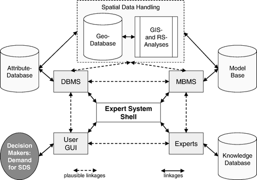
A spatial decision support system (SDSS) is defined as a system which comprises a decision support system (DSS), a geographic information system (GIS), and a model base management system (MBMS). The latter, as well as the knowledge analysis, is part of DSSs. In , the general architecture of a SDSS is shown according to Leung (Citation1997) and Malczewski (Citation1999). The idea of such a system is the overall SDSS development environment. This development combines the state of the art in software and knowledge engineering and in spatial data analysis. The latest approaches are, for example, described by Laudien and Bareth (Citation2007) using Java and ESRI's ArcGIS Engine for SDSS programming. The centre of the SDSS is the expert system shell, which coordinates the whole system. It is responsible for the information flows and directs control flows. The communication between the DBMS, the MBMS, the knowledge base, and the spatial data handling unit is implemented by interfaces. The interface for a decision maker is usually a graphical user interface (GUI) which provides access to the system for spatial decision support (SDS).
Figure 1. Architecture of a spatial decision support system (SDSS) (modified from Leung, Citation1997).
For environmental resource management, models and the availability of spatial data play an important role. Consequently, the development of such models is of central importance for the whole approach. Therefore, the focus in this contribution will be on (i) the structure of an adequate spatial database for SDSSs that focus on environmental resource management, (ii) the integration of models into the SDS, and (iii) the interfaces which are necessary for the whole system to ensure the communication between the SDSS components as shown in .
In the last two decades, public interest in environmental issues owing to human activities in forest and agricultural ecosystems has increased significantly. Therefore, these topics became part of public policy. For policy decision making, information for decision support is essential and derives from research activities (McCloy Citation2006, Sharma et al. Citation2006). For generating information about related environmental problems and resource management, the development of complex ecosystem models during the last 30 years can be regarded as one of ‘the biggest revolutions in the study of soil C/N cycling’ and related processes (Shaffer et al. Citation2001), which are closely related to global and climate change research. Traditionally, these models were developed and used for point or site-specific applications (Hartkamp et al. Citation1999). Independent from these studies, regional estimates were calculated on the basis of the ecosystem approach, which multiplies the area of a defined ecosystem with e.g. N2O-emissions (Matson and Vitousek Citation1990, Jungkunst et al. Citation2006).
For complex regional modelling or decision support for agriculture and/or forestry, the latter approach is not sufficient (Beauchamp Citation1997, Jones et al. Citation2003). Therefore, using a GIS is necessary. Although, in some DSS approaches, spatial analysis has been considered (Matthews and Knox Citation1999), it has been used less frequently in ecosystem scenario simulation. Shaffer and Ma (Citation2001) state that process-based agro-ecosystem models interfaced with GIS will be the next ecosystem model generation.
In general, a GIS provides methods for spatial data capture, storage, analysis, and presentation (Bill Citation1999). The elements of a GIS are hardware, software, data, application, and user. GISs were introduced in the late 1960s (Burrough and McDonnell Citation1998) and worked only on mainframes. The fast development of computer hardware and software facilitated the rapid development of GIS in the 1980s for application on workstations. In the early 1990s, powerful GIS-software was available for MS-Windows operating systems and supported the wide distribution of applications of GIS-technologies. Nowadays, GIS-applications and -users are increasing rapidly, facilitated by WebGIS applications such as VirtualEarth or GoogleEarth and the GIS developments for personal location-based services, routing and navigation. Latest developments are based on spatial web portal (SWP) technologies introduced by Yang et al. (Citation2007).
Until the late 1980s, the development of process-based ecosystem models and GIS were separated. This changed significantly in the beginning of the 1990s. The interfacing of such models with GIS was part of several research activities to satisfy the increased demand for regional information for decision support (Engel et al. Citation1993, Hoogenboom et al. Citation1999). Still, owing to the limited data availability for regional applications, these applications were very restricted. In the late 1980s, governmental bureaus and/or commercial companies started offering more and more digital spatial data products. Interfaces for the import of these data into commercial GIS software were implemented (Maidment Citation1996). Consequently, the increased availability of spatial data lead to more regional and national GIS applications interfaced with process-based ecosystem models (Falloon et al. Citation1998, Li et al. Citation2001, Brown et al. Citation2002, Jones et al. Citation2003). Recently, the establishment of national geodata infrastructure has become the focus of many research activities (Bilo and Bernard Citation2005).
Nowadays, the limitation of process-based environmental decision support is still the availability of spatial data. This problem derives from the fact that the process-based models were developed for site or plot scales and input data for this scale are not available on regional or national levels. There are three ways to solve this problem: (i) to sample the necessary input data, e.g. management data, detailed land use information etc., which is usually not possible for large areas, (ii) to aggregate and generalise the inputs from available sources (Li Citation2000), which is sometimes not a satisfying approach, or (iii) to use GIS-, remote sensing (RS)-technologies and data generation methodologies, and data mining techniques to create the lacking spatial information for the regional applications (Bock and Köthe Citation2005, Eastman Citation2005, Hansen Citation2005).
The availability of and the access to digital geodata is a key issue in macro, meso and micro scale GIS modelling of environmental issues (Bareth and Yu Citation2002, Bambacus et al. Citation2008) and consequently for SDS for resource management as well. While it is still possible to collect necessary geodata with a limited amount of time and money for micro scale modelling, it is essential to have secondary sources for meso and macro scale modelling. Owing to the limitations of data availability and data detail, the GIS- and RS-based production of new data becomes essential in regional resource management (McCloy Citation2006). The generation of new data has to satisfy the demand of the inputs for available process-based ecosystem models. Therefore, to facilitate the technologies for data generation and data mining, setting-up an extensive geodata infrastructure for serving regional ecosystem modelling approaches is a precondition for spatial modelling in general (Goodchild Citation1996) and this counts for resource management, too. Bill and Fritsch (Citation1994) call a GIS for environmental applications an environmental information system (EIS). However, the term EIS is often also used in a non-GIS context. Consequently, a GIS for environmental applications in a spatial context can be regarded as a spatial environmental information system (SEIS).
A SEIS is considered as an extensive geodatabase or rather a spatial data infrastructure, which includes all data for modelling purposes, the model itself, as well as the functions for data generation and data mining. Additionally, metadata must be included in the SEIS for considering international standards defined by ISO and OpenGIS (Guptill Citation1999, Bernhardsen Citation2002). Another important point is the information about data quality in the decision making process (Veregin Citation1999). In general, information about the data quality is lacking in many GIS applications (Heuvelink Citation1999). However, knowledge of data quality is essential. ‘If data quality is an important property of almost all geographical data, then it must affect the decisions made with those data. In general, the poorer the quality of the data, the poorer the decision. Bad decisions can have severe consequences’ (Longley et al. Citation1999). This is a very important issue because the SEIS serves as a SDSS for environmental resource policies in managed and unmanaged ecosystems.
2. Spatial decision support systems
The development of SDS for environmental resource management, e.g. forest and agro-ecosystem management, biodiversity conservation, or hydrological planning, started in the 1980s and was the focus of many research groups in the 1990s (Wright et al. Citation1993, Leung Citation1997, Naesset Citation1997, Crist et al. Citation2000). While the first developments derived from the early enthusiastic attempts to develop decision models in the 1960s and 1970s (Davis and McDonald Citation1993), the technological progress in electronical computing, GIS- and RS-software development, and communication infrastructure in the 1990s enabled the design and implementation of more complex SDSSs such as NELUP, ArcForest, SARA, or RELMdss (O'Callaghan Citation1995, Mowrer 1997). NELUP, the NERC-ESRC Land Use Programme, was developed for rural land use planning on the basis of watershed modelling approaches (O'Callaghan Citation1996). Hydrological, agricultural, economical, and ecological sciences were included. It comprises socio-economic and ecosystem modelling approaches. ArcForest was developed by ESRI Canada to support forest management and planning (Mowrer 1997). It was developed using the software tools ArcInfo and Oracle for an UNIX environment. SARA, the Spreadsheet Assisted Resource Analysis, was also developed for forest management and includes linear programming models for economic analysis to determine economic-ecological tradeoffs, too (Mowrer 1997). It was interfaced with GIS on the input and output side. The Regional Ecosystem and Land Management decision Support System (RELMdss) was developed by Prof. Richard Church (NCGIA, UCSB) for a Windows environment (Church et al. Citation2000). The system was developed to generate and implement forest and land use plans. Some of the systems of that period included complex economic-ecological spatial modelling approaches for resource management (Dabbert et al. Citation1999, Bouman et al. Citation2000). Bouman et al. (Citation2000) describe ‘Tools for Land Use Analysis on Different Scales’. In this paper, comprehensive economic-ecological modelling approaches are described and interfaced with GIS for regional scenario creation for Costa Rica. Statistical regression, linear programming, process-based and expert knowledge modelling approaches were applied in this framework. The same is true for the regional modelling approach for sustainable and environmentally compatible land use in the state of Baden-Württemberg, Germany (Dabbert et al. Citation1999). The hardcopy of this contribution comes with a CD-ROM which provides a windows-based user interface for the regional modelling framework. The GIS part is programmed with ESRI's MapObjects and VBA. Several interfaces were programmed to link the socio-economic and environmental models.
Simultaneously, governmental bureaus, e.g. for surveying and mapping, made enormous efforts in the 1980s to establish digital databases for topography, geology, soil, climate, etc. (Longley et al. Citation2005). These developments actually started in the early 1970s and in this first stage, the focus was on pure spatial data (Bill and Fritsch Citation1994). At the same time, official and/or commercial companies started to provide digital spatial data, e.g. remote sensing data. The launch of Landsat-1, formerly known as ERTS-1 in 1972, was the start to involve satellite analysis in resource management (McCloy Citation2006). Further milestones in remote sensing sensor development were the development of radar systems (e.g. Seasat, ERS-1, JERS-1), the launch of SPOT-1 in 1986 with a linear array sensor, of IKONOS in 1999 with a 1 m resolution, and the latest launch of the radar sensor TerraSAR-X with a 1 m resolution (http://www.infoterra.de) (Lillesand et al. Citation2004).
Finally, the availability of GPS technologies since 1988 (NAVSTAR-GPS) and the full availability since 1995 can also be considered a milestone for decision support of environmental resources. Accurate and mobile positioning and navigation measurements are a precondition for spatial data capture and analysis. Especially for environments with poor topographic data coverage, the positioning technologies are a key method to capture environmental and socio economic data. Before the turn off on 1 May 2000 of the SA (selective availability), the use of correction systems in positioning was mandatory. Global DGPS providers such as Omnistar (www.omnistar.com) were more important in that period. Nowadays, WAAS services and/or regional DGPS services such as SAPOS in Germany (http://www.sapos.de) enable cm accuracies in positioning with L1- and L2-GPS receivers.
Since the new millennium, a new generation of SDSSs is in the focus of the research community considering the latest developments in remote sensing, GIS, and geodata infrastructure. The realisation of software developments, which are independent of operating systems, but dependent on high-performance network capabilities and partly grid computing environments, are in progress. The GLOWA DANUBE (http://www.glowa-danube.de) and the GLOWA IMPETUS (http://www.impetus.uni-koeln.de) projects for example represent such spatial modelling approaches for water management decision support with extensive knowledge, model and geo databases. The SDSSs are developed in Java including different approaches of GIS and RS analyses for a network-based client-server environment. Similar SDSS frameworks were introduced in the early 2000s. For example, David et al. (Citation2004) presented the GEOLEM approach as an interoperable modelling framework. GEOLEM (Geospatial Object Library for Environmental Modelling) aims for the elimination of GIS-specific knowledge in a modelling framework and vice versa (David et al. Citation2004). The above mentioned GLOWA projects exactly follow this new paradigm for SDS including a modelling framework. Additionally, it is possible to integrate expert knowledge by using expert systems. Malczewski (Citation1999) describes expert systems in a spatial context as spatial expert systems (SES). Integrated systems of SDSS combined with SES are considered ‘intelligent SDSSs (ISDSSs) or spatial expert support systems (SESSs)’.
Finally, the combined availability of spatial data and communication, computing, positioning, GIS- and RS-technologies were utilised for the implementation of complex SDSS since the late 1990s. The regional GIS-based modelling of environmental resources and therefore of ecosystems in general requires setting-up extensive geo and model databases. Spatial data about topography, soil, climate, land use, hydrology, flora, fauna and anthropogenic activities have to be available. The lack of adequate spatial databases is still a limiting factor in SDS and accordingly in regional ecosystem modelling. Therefore, GIS- and RS-technologies are of central importance for spatial data handling and analysis to implement the required database. As introduced above, a GIS-based EIS is defined as a SEIS. It uses the latest technology developments and can be considered as a spatial data infrastructure for decision support that is related to questions and problems of environmental resource management.
3. Structure of SEIS
The establishment of SEIS requires setting-up of a extensive geo- and attribute-database. Especially modelling of C- and N-cycles of ecosystems requires numerous input parameters e.g. pH, soil texture, fertilizer N-Input, animal waste input, use of irrigation water, dates of sowing and harvest, yield, etc. (Charles-Edwards et al. 1996, Grant Citation2001, Seppelt Citation2003). In general, data about climate/weather, hydrology, soils, land use, and management are essential and must be available in SEIS. Furthermore, methods and models for data analysis and data presentation have to be integrated.
The structure and elements of a SEIS are visualised in . Owing to the definition and the defined task of a SEIS, this computer based system is understood as a GIS for environmental resource applications and includes seven different information systems which are:
-
Base Geo Data Information System (BGDIS)
-
Soil Information System (SIS)
-
Hydrological Information System (HIS)
-
Climate Information System (CIS)
-
Land Use Information System (LUIS)
-
Spatial/Temporal Biodiversity Information System (STBIS)
-
Forest/Agricultural Management Information System (FAMIS)
Figure 2. Structure of a spatial environmental information system (SEIS).
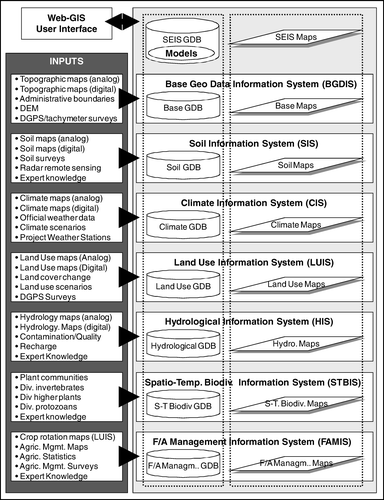
Most important for spatial matching and for georeference of all data in a SEIS is the integration of framework datasets within a Base Geo Data Information System (BGDIS) (Fürst et al. Citation1996). The use of an available information system provided by official sources, such as official bureaus for surveying and mapping, is recommended to meet this requirement. For example in Germany, there is an official digital topographic database in vector format for different scales available (1:25,000; 1:250,000; 1:1,000,000) (http://www.atkis.de). The use of unique base geodata enables the exchange of data between independent projects and applications. The BGDIS needs to provide topographical data, elevation lines or a digital elevation model (DEM), a set of ground control points (GCPs), and an administrative boundary data set. The latter are important because statistical data for administrative units can be linked to GIS for the implementation of spatial information systems (Bareth and Yu Citation2002). The integration of a DEM is important for relief analyses (e.g. computing aspect, inclination, etc.) and 3-D-visualisations. If digital base geodata are not available or accessible, the establishment of a BGDIS is necessary. For this task, aerial or satellite-based survey campaigns, digitisation of topographical maps, and/or GPS/tachymeter surveys are standard methods (Bill Citation1999).
The soil information system (SIS) is essential for providing soil parameters for the agro-ecosystem modelling. Many applications of regional modelling of agricultural issues use soil maps to derive spatial soil parameters for model inputs (e.g. Falloon et al. Citation1998, Matthews and Knox Citation1999, Brown et al. Citation2002). Therefore, the SIS has to include (i) spatial soil information and (ii) a detailed description of the soil types including soil genesis, physical and chemical soil properties (see ) (Le Bas et al. Citation1996). In case soil maps are not available, surveys have to be carried out or methods of computed soil map generation (McBratney et al. Citation2003, Scull et al. Citation2003, Bock and Köthe Citation2005) have to be applied to create a SIS. If soil maps are available but lack detailed descriptions of soil types, expert knowledge can be used to generalise typical soil properties. Usually, soil data are not fully available for scales ranging between 1:10,000 and 1:200,000. If these data exist, the information level often does not fit to the model requirements. Therefore, methods of soil map generation need to be considered for the establishment of a SIS. Examples of GIS-based soil mapping are described e.g. by Bareth (Citation2001a), Carré and Girard (Citation2002) and Zhu et al. (Citation1997, Citation2001). Bareth (Citation2001a) describes a knowledge-based approach to disaggregate available soil information on the basis of a computed relief analysis of a DEM. Carré and Girard (Citation2002, Bock and Köthe Citation2005) use regression kriging for soil mapping. In their analysis, they consider landform and land cover, derived from a DEM and satellite image analysis. An expert knowledge-based fuzzy soil inference scheme (soil–land inference model, SoLIM) was introduced by Zhu et al. (Citation1997, Citation2001). The authors combine techniques of GIS, fuzzy logic and inference for digital soil mapping. Reviews on the state of digital soil mapping are given by McBratney et al. (Citation2003) and Scull et al. (Citation2003). Finally, radar remote sensing can be additionally applied to derive soil parameters such as soil moisture or soil bulk density (Dobson and Ulaby Citation1998, Woodhouse Citation2005).
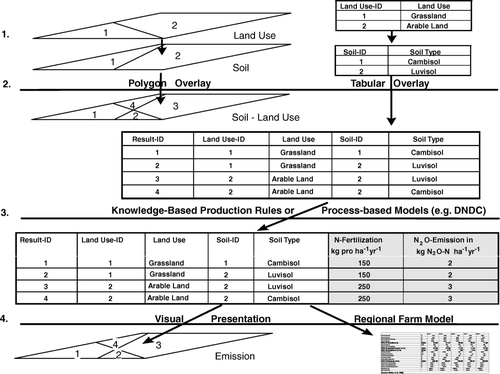
Figure 3. Model integration into the GIS-based soil-land use-system approach (modified from Bareth Citation2005).
The climate information system (CIS) provides the necessary climate/weather data (compare ). Available climate maps can be digitised if there are no digital data available. Usually, weather data is obtainable from official meteorological bureaus and weather services (e.g. http://www.dwd.de). For the generation of detailed weather maps from point data, GIS-interpolation methods can be applied (Running and Thornton Citation1996, Matthews et al. Citation1999, Thomas Citation2002). Again, the basis for using topography to interpolate weather data is a DEM, which should be available in the BGDIS, and land use information which should be available in the LUIS. Additionally, weather data can be collected from weather stations of research projects. In general, the availability and accessibility of daily weather data from official and commercial sources are guaranteed. An important issue is the availability of various climate scenario data in the CIS which is important to simulate the impact agricultural systems in the future (Hansen Citation2005, Sarkar and Kar Citation2006).
Land use data also have to be available in a SEIS for regional modelling. These data should be organised in a land use information system (LUIS) (compare ). Usually, land use maps are available, but they lack the necessary information detail. In official land use maps, agricultural land use is generally differentiated between arable land, grassland, orchards and some special land use classes such as paddy fields. For detailed agro-ecosystem modelling, this information resolution is rather poor. Detailed land use maps which provide information about the major crops and crop rotations are necessary. The analysis of multispectral, hyperspectral and/or radar data from satellite or airborne sensors is a standard method to retrieve such information with remote sensing methodologies (Sommer et al. Citation1998, Lillesand et al. Citation2004). By using a multidata approach, the retrieved information from multitemporal and multiannual remote sensing analysis can be integrated into official land use maps to enhance both the information level (e.g. crop rotation) of existing land use data and the quality of the land use classification (Bareth Citation2001b, Rohierse and Bareth Citation2004, Bareth Citation2008). Besides the remote sensing methods, digital land use data can be created by field surveys or by digitisation of available land use maps. Additionally, land use data from agricultural statistics have to be integrated into a SEIS. Information such as arable land per administrative unit, total sown area, etc. can be retrieved from these sources (Bareth and Yu Citation2002). In addition for the simulation of scenarios, the results of land-cover change models have to be incorporated, which are reviewed by Eastman (Citation2005). Another method to provide land use change data for agricultural systems is the economic modelling of regional farms considering environmental or political conditions (Bareth and Angenendt Citation2003, Neufeldt et al. Citation2006).
Given the important controlling influence of water upon ecosystems, it is essential that ecosystem models provide detailed knowledge of hydrological conditions. Therefore, data describing the dominant water cycle components have to be integrated as a hydrological information system (HIS). These include precipitation, evaporation, evapotranspiration, soil moisture, groundwater, and runoff / river discharge. If such data are not available, they can be acquired through a combination of approaches including field monitoring at reference sites and the use of remote sensing techniques (e.g. for soil moisture, evapotranspiration, groundwater), and/or modelling. The application and integration of hydrological models into the MBMS is also an important task for the SEIS.
The spatio-temporal biodiversity information system (STBIS) finally forms the key component for the establishment of the multi-trophic diversity models. As such, the STBIS combines all multi-trophic diversity datasets in a central spatial sub-information system, and should include high-resolution habitat-specific data combining terrestrial and aquatic ecosystems. Data from all the other sub-information systems have to be evaluated for correlations between biodiversity patterns and the environmental parameters. It is obviously of high importance for the creation of the SDSS focusing on sustainable resource management and e.g. biodiversity conservation.
Setting-up an agricultural management information system (FAMIS) (compare ) is a crucial part of the implementation of a SEIS. For regional agro-ecosystem modelling, farm management data on regional level e.g. fertilizer N-Input, animal waste input, use of irrigation water, dates of sowing and harvest, yield, etc. are a must. The regional availability of this kind of spatial information is rather poor and research about how to regionalise management data has not yet been intensively investigated, e.g. how to distribute animal waste and mineral fertilizer inputs in a region. The application e.g. of average N-fertilizer input derived from agricultural county statistics is not satisfying for the regional application of agro-ecosystem models (Li et al. Citation2002). Working on a regional scale, it is usually not possible to set up a spatial database which provides this information for all fields of the farmers in the region. Therefore, this kind of information has to be generated using results from farm surveys, from agricultural statistics and from expert knowledge. Using all these sources, it is possible to define typical farm management for distinct crops and crop rotations in a special climate for a region which can be linked to the detailed land use information in the LUIS and the spatial weather data of the CIS (Rohierse Citation2003). Consequently, the LUIS combined with the CIS become the basis for the FAMIS and so for the regionalisation of agricultural management within a region.
Finally, a SEIS is the sum of the described information systems. They are linked to each other for further analysis and data mining using GIS technologies. Additionally, models and methods for agricultural environmental modelling have to be integrated in the SEIS (compare ). In the context of a SDSS, models are organised in a Modelbase Management System (MBMS) (Leung Citation1997) and interact with the spatial data by defined interfaces (). Therefore, it is possible to link or even integrate complex agro-ecosystem models into GIS (Hartkamp et al. Citation1999, Seppelt Citation2003) and consequently into a SEIS as well. The selection of the methods and models which are integrated into a SEIS has a further important impact on the set-up of the geo- and attribute-database. The methods and models require distinct input parameters. Consequently, the first step of setting-up a SEIS is the selection of the methods and models which are integrated in the SEIS later. The methods and models define the demand of the data and of the required interfaces of a SEIS.
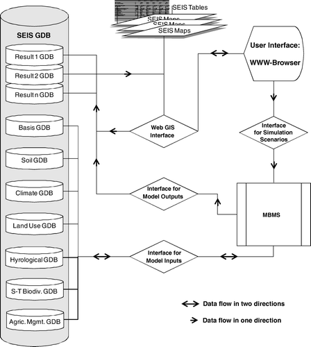
Figure 4. Interfaces and data flow for model integration into a SEIS.
4. Integration of models in a SEIS
Traditionally, process based agro-ecosystem models or agronomic models are generally developed and used for site or field scales (Ma and Shaffer Citation2001, McGechan and Wu Citation2001). Therefore, interfacing GIS and remote sensing with agro-ecosystem models is becoming more important (Schneider Citation2003). Shaffer et al. (Citation2001) state that ‘the linkage of process-level models to GIS will be the next generation of model application for spatially distributed fields or watersheds’.
Hartkamp et al. (Citation1999) describe four different ways to interface GIS with agronomic models. They also introduce definitions for the different ways of interfacing:
-
Interface: the place at which diverse (independent) systems meet and act on or communicate with each other.
-
Link: to connect.
-
Combine: to unite, to merge.
-
Integrate: to unite, to combine, or incorporate into a larger unit; to end segregation.
Linking GIS with models is basically just an exchange of files or data. In this case, the model is independent from the GIS and vice versa. Only the results of each system are exchanged. Often it is also described as loosely coupled (Longley et al. Citation2005). Combining GIS with models, also described as closely coupled (Longley et al. Citation2005), involves processing data and automatically exchanging data. Finally, integrating GIS and models describes the real incorporation of one system into the other. For the user, only one GUI is provided and the model is programmed in a GIS framework (Laudien et al. Citation2007). This approach is also defined as embedded (Longley et al. Citation2005).
Especially for regional modelling of C-and N-dynamics in (agro-)ecosystems on a regional scale, the integration of such models is important and can be regarded as a key issue (Shaffer et al. Citation2001). Available approaches of GIS-model interfaces for agro-ecosystem models hardly use the GIS-analysis capabilities. For example, the denitrification and decomposition model (DNDC) (Li et al. Citation2001) has, in its latest versions, a regional model part included. Spatial parameters such as land use and soil are not considered in their spatial relation. GIS-functionalities are only used to display the results on county levels using a county map. Plant and Bouman (Citation1999) described a GIS-DNDC-interface of the linking type for the Atlantic zone of Costa Rica. The introduced approach is not automated and consequently very difficult to use for other regions. Other examples of linking GIS and models are given e.g. by Engel (Citation1997), Falloon et al. (Citation1998), Garnier et al. (Citation1998), Ma and Shaffer (Citation2001), McGechan and Wu (Citation2001). These studies clearly show the importance of interfacing agro-ecosystem models with GIS. Therefore, a method for integrating process-based agro-ecosystem models into a GIS is described in .
The method for the integration of agro-ecosystem models into GIS is based on the soil-land use-system approach (SLUSA) (Bareth et al. Citation2001). SLUSA is based on the ecosystem approach described by Matson and Vitousek (Citation1990). The ecosystem approach was improved in order to estimate and visualise greenhouse gas emissions (CH4, CO2, N2O) from agricultural soils for a distinct region (Bareth 2003). The improvement of the ecosystem approach described by Matson and Vitousek (Citation1990) was undertaken by using a GIS and available digital spatial data. SLUSA is a GIS- and knowledge-based approach for environmental modelling. In , the methodology of SLUSA is shown. The first step consists of setting-up a GIS which contains relevant data and represents the necessary geodata infrastructure for the modelling task. In the second step, GIS tools are used to overlay climate, soil, land use, topography, farm management, and other data such as preserved areas or biotopes (if available). This procedure is the basis for the spatially related identification of different soil-land-use-systems which represents unique systems similar to the introduced ecotopes or hydrotopes (Seppelt Citation2003). In the third step, measurement data and process knowledge of the region of interest as well as from literature are linked to these systems. For the linkage, knowledge based production rules are programmed. The latter ones are commonly used to generate new knowledge from expertise in knowledge based systems such as expert systems (Wright et al. Citation1993).
Based on SLUSA, describes the integration of agro-ecosystem models into GIS. While the steps 1 2 and 4 remain in the method, the third step in SLUSA is changed. The implementation of the knowledge based production rules of SLUSA is replaced by the integration of an agro-ecosystem model. All input parameters for the model are derived from the GIS-database. The advantage of this method is the automatic spatial modelling. Huber et al. (Citation2002) adapted e.g. the DNDC model program code for that purpose and necessary interfaces were programmed using COM (Microsoft component object model), which is also used for GIS-based spatial data analysis by Ungerer and Goodchild (Citation2002).
In , the essential interfaces for model incorporation of and the dataflow in SEIS are shown. In a SEIS geo-database (GDB), the described BGDIS, SIS, CIS, LUIS, and AMIS are integrated. In the example of , an agro-ecosystem model can now retrieve the input parameters for a model run from the SEIS. For this step, an interface for the communication between the model and the SEIS has to be developed e.g. by Laudien et al. (Citation2007) and Huber et al. (Citation2002). Data flow between the model and the SEIS is in both directions, because the information of what kind of data the model needs for a model run goes to the SEIS and then the model receives the input parameters. The modelling results are then stored via an interface for model output in a new geo-databases of the SEIS. Data flow is in one way from the model to the SEIS. Finally, it is then possible to use GIS-tools for data export and visualisation, e.g. for map, table or graphic layout productions. An interface for user defined creation of simulation scenarios should be implemented as well (Laudien et al. Citation2007). This interface would enable the user to create new simulation scenarios, for example for SDS to develop sustainable strategies in agriculture. Here, the data flow is in one direction from the user interface via the interface for simulation scenarios to the models. Finally, full or limited SEIS data access should be provided to users via a WebGIS. A WebGIS represents the interface for users who use standard browsers to access the SEIS.
All interfaces can be implemented by available technologies for a service oriented architecture (SOA) (Stollberg and Zipf Citation2008). Latest approaches are based on programming JAVA and/or AJAX interfaces (Baaser et al. Citation2006, Laudien and Bareth Citation2007) or should be based on a spatial web portal (SMP) using portlet technologies, web services for remote portlets, Java specification request, and OGC patial web services (Yang et al. Citation2007). Additionally, the communication between the different databases of the sub-information systems and the different components of a SDSS can be solved using PHP, CGI and/or XML, too. Additionally, latest OGC standards such as Web Processing Service (WPS) should be implemented. Thereby, it is possible to link and integrate complex socio-economic biodiversity/ecosystem models into the GIS with various methods (Hartkamp et al. Citation1999, Seppelt Citation2003) and consequently into the proposed structure of a SEIS.
5. Discussion and conclusions
The importance of tools for spatial data handling in the framework of decision making and regional resource management for managed and unmanaged forest and agricultural ecosystems is obvious. Therefore, McCloy (Citation2006) describes regional resource management information systems (RMIS) in the context of spatial data handling and analysis tools. The combined application of GIS, remote sensing and DSS technologies are the keys for such systems (McCloy Citation2006). According to Malczewski (Citation1999), the establishment of a SESS integrates the methods of SDSS and SES. Consequently, this also takes into account for the SDS for resource management (Jones et al. Citation2003). GIS and remote sensing can be used to bridge the demands from site-specific applications to regional and national ones (e.g. Plant and Bouman Citation1999, Brown et al. Citation2002, Chowdary et al. Citation2005). Shaffer et al. (Citation2001) state the importance of GIS interfaced agro-ecosystem models. The technical issues of how to interface models with GIS are widely discussed in literature, e.g. by Hartkamp (1999), Longley et al. (Citation2005), Miller et al. (Citation2005) or Seppelt (Citation2003). In addition, numerous solutions and applications are described (e.g. Ma and Shaffer Citation2001, McGechan and Wu Citation2001, Jones et al. Citation2003), also in a spatial decision context (e.g. Dabbert et al. Citation1999, Laudien et al. Citation2007).
While there is immense knowledge available about SOA and SWP technologies (Bambacus et al. Citation2007), SDSS implementation (Laudien et al. Citation2007, Stollberg and Zipf Citation2008), model development, calibration and evaluation, there is still a need for improvement to simulate e.g. the whole C- and N-cycle in forest and agro-ecosystems on a regional level (Shaffer et al. Citation2001, Benbi and Richter Citation2002). McCloy (Citation2006) points out that the key level of management in terms of resource sustainability is the regional level. For regional applications of GIS interfaced models, the problems are more on the side of data availability and quality as well as on extrapolation of the site-specific models (Heuvelink Citation1999, Bareth Citation2005). On the one hand, quality and accuracy is a big issue for the development of models and the evaluation and calibration is always discussed. On the other hand, regional applications of agro-ecosystem models rarely discuss the quality of the regional input parameters and their impact on simulation results. In particular, the quality of available soil type parameters, land use data, and agricultural management does not fit to the philosophy of site specific process-based models which simulates what crop is grown where, on which soil, in which climate, and with what kind of management (Bareth Citation2005). This is also stated by Kersebaum et al. (Citation2007). By comparing different agro-ecosystem models, the authors conclude that ‘applications of agro-ecosystem models on a field or regional level are mostly characterised by a high uncertainty of input data, especially regarding soil and management information’. Focusing on the latter problem, the SEIS approach proposes a solution, the multidata approach (MDA) for enhanced land use mapping (Bareth Citation2008), in the context of the LUIS and the FAMIS. Here, the SEIS can significantly enhance the spatial modelling framework by providing adequate spatial data. Consequently, the quality of the regional input data is a key issue in spatial resource management and affects the decisions made with those data: ‘the poorer the quality of the data, the poorer the decision’ (Longley et al. Citation1999).
Regional modelling with agro-ecosystem models means the handling of an extensive geodata infrastructure. Hence, GIS and remote sensing technologies have to be applied. Those tools also provide measures for data quality for the evaluation of the spatial input data. Additionally, concepts and standards for the description of the data, the metadata, are integrated in many commercial GIS and remote sensing software. Therefore, the regional modelling of agricultural-environmental issues should be based on a strict architecture: the GIS- and RS-based SEIS, which enables
-
the data capture (also of spatial data),
-
the data storage and management (also of spatial data),
-
the data analysis and manipulation (also of spatial data),
-
the generation of new data (for model input),
-
the interfacing of GIS and models,
-
the application of metadata standards, and
-
the presentation (maps, tables, etc.) of the SEIS (including the modelling results).
The proposed structure of the SEIS provides the necessary database functionalities combined with the capability to deal with spatial data. Additionally, the implementaion of open GIS standards such as Web Map Service (WMS), Web Feature Service (WFS), Geography Markup Language (GML), Styled Layer Descriptor (SLD), Web Coverage Service (WCS), Catalogue Service for the Web (CSW), Web Coordinate Transformation Service (WCTS), and Web processing Service (WPS) are important for future developments of object oriented modelling approaches and the related data inputs in a SOA.
By combining this structure of a SEIS with modern software development tools, such as Java and ArcGIS Engine or GeoTools (both for spatial data analysis and handling), it is possible to implement powerful SDSSs for environmental resource management including appropriate models and expert knowledge. With this development framework, a SDSS developer can satisfy the requirements of a modern SDSS according to .
Notes on contributor
Georg Bareth is a Professor of Geography at the University of Cologne, Germany, and the Head of the GIS & RS Group of the Geography Department. He received his Diploma degree from Technical University Stuttgart in Geography in 1995 and his PhD in Agricultural Informatics from University of Hohenheim-Stuttgart in 2000. His habilitation was also done in Agricultural Informatics at the University of Hohenheim-Stuttgart in 2004. He is a co-chair of the ISPRS WG VII/5 ‘Methods for change detection and process modelling’. His current research focuses on geographic information science, remote sensing, and 3D-analyses.
Related Research Data
References
- Baaser , U. , Gnyp , M.L. , Hennig , S. , Hoffmeister , D. , Köhn N. , and Bareth , G. , 2006 . Online CampusGIS for the University of Cologne . Proc. AGIT'2006 , Heidelberg : Wichmann Verlag , 24 – 31 . In German .
- Bambacus , M ., Yang , C ., Evans , J . Li , Z ., and Li , W ., 2008 . Sharing earth science information to support the Global Earth Observing System of Systems (GEOSS) . In : Proceedings of IGARSS 2008 , 6–11 July 2008, Boston, CD-ROM, IEEE International Geoscience and Remote Sensing Symposium .
- Bambacus , M. , Yang , P. , Evans , J. , Cole , M. , Alameh , N. and Marley , S. 2007 . An interoperable portal supporting prototyping geospatial applications . URISA Journal , 19 ( 2 ) : 15 – 21 .
- Bareth , G. , 2008 . Multi-data approach (MDA) for enhanced land use and land cover mapping . The International Archives of the Photogrammetry, Remote Sensing and Spatial Information Science , XXXVI . Part B , 1059 – 1065 .
- Bareth , G ., 2005 . Uncertainty of regionalization with agro-ecosystem models and GIS , Proc. of the 4th International Symposium on Spatial Data Quality '05 , 212 – 220 .
- Bareth , G. and Angenendt E. , 2003 . Economic-ecological modeling of greenhouse gases from agriculture at the regional level . Berichte über Landwirtschaft , 81 1 , 29 – 56 . In German with English summary .
- Bareth , G. , 2001a . Disaggregation of a soil map 1.200,000 by using a relief analysis of a 50 m DEM . GIS, Journal for Spatial Information and Decision Making , 12/2001. Heidelberg: Wichmann Verlag , 33 – 40 . In German with English abstract.
- Bareth , G. , 2001b . Integration of an IRS-1C land use classification in the official topographical information system (ATKIS) to enhance the quality of the information of arable land and grassland for a dairy farm region in Southern Germany (In German with English abstract) . GIS, Journal for Spatial Information and Decision Making, 6/2001 . Heidelberg : Wichmann Verlag, Heidelberg , 40 – 45 .
- Bareth , G. and Doluschitz , R. 2003 . Wissens- und GIS-basierte regionale Abschätzung von Kohlendioxid-, Methan- und Lachgas-Emissionen aus landwirtschaftlicher Landnutzung . Z. Agrarinformatik , 4 : 52 – 64 .
- Bareth , G. , Heincke , M. and Glatzel , S. 2001 . Soil-Land-use-system approach to estimate nitrous oxide emissions from agricultural soils . Nutrient Cycling in Agroecosystems , 60 ( 1–3 ) : 219 – 234 .
- Bareth , G. and Yu , Z. , 2002 . Agri-enviro-information-system for the North China Plain Proceedings of International Society for Photogrammetry and Remote Sensing (ISPRS) Commission II Symposium of Integrated Systems for Spatial Data Production, Custodian and Decision Support, ISPRS , 23 – 29 .
- Beauchamp , E.G. 1997 . Nitrous oxide emission from agricultural soils . Canadian Journal of Soil Science , 77 : 113 – 123 .
- Benbi , D.K. and Richter , J. 2002 . A critical review of some approaches to modeling nitrogen mineralization . Biology and Fertility of Soils , 35 : 168 – 183 .
- Bernhardsen , T. 2002 . Geographic information systems: an introduction , New York : Wiley .
- Bill , R. , 1999 . Heidelberg : Wichmann Verlag .
- Bill , R. and Fritsch , D. 1994 . Grundlagen der Geo-Informationssysteme, Band 1: Hardware, Software und Daten , Heidelberg : Wichmann Verlag .
- Bilo , M. and Bernard , L. 2005 . “ INSPIRE – Aufbau einer Infrastruktur für raumbezogene Informationen in Europa ” . In Geodateninfrastruktur – Grundlagen und Anwendungen , Edited by: Bernard , L. , Fitzke , J. and Wagner , R.M. 18 – 28 . Heidelberg : Wichmann Verlag .
- Bock , M. and Köthe , R. 2005 . “ Regionalisierung von Bodenkennwerten zur Ableitung von funktionalen Bodenkonzeptkarten ” . In GIS-gestützte Bewertung von Bodenfunktionen , Edited by: Möller , M. and Helbig , H. 35 – 44 . Heidelberg : Wichmann Verlag .
- Bouman , B.A.M. , Jansen , H.G.P. , Schipper , R.A. , Hengsdijk , H. and Nieuwenhuyse , A. 2000 . Tools for Land Use Analysis on Different Scales, With Case Studies for Costa Rica , Dordrecht, Boston, London : Kluwer Academic Publishers .
- Brown , L. , Syed , B. , Jarvis , C. , Sneath , W. , Phillips , R. , Goulding , W.T. and Li , C. 2002 . Development and application of a mechanistic model to estimate emission of nitrous oxide from UK agriculture . Atmospheric Environment , 36 : 917 – 928 .
- Burkart , M.R. and James , D.E. 1999 . Agricultural nitrogen contributions to hypoxia in the Gulf of Mexico . Journal of Environmental Quality , 28 : 850 – 859 .
- Burrough , P.A. and McDonnell , R.A. 1998 . Principles of geographic information systems , 1998 Oxford : Oxford University Press .
- Carré , F. and Girard , M.C. 2002 . Quantitative mapping of soil types based on regression kriging of taxonomic distances with landform and land cover attributes . Geoderma , 110 ( 3/4 ) : 241 – 263 .
- Charles-Edwards , D.A. , Doley , D. and Rimmington , G.M. 1986 . Modelling plant growth and development , Sydney : Academic Press .
- Chowdary , V.M. , Rao , N.H. and Sarma , P.B.S. 2005 . Decision support framework for assessment of non-point-source pollution of groundwater in large irrigation projects . Agricultural Water Management , 75 ( 3 ) : 194 – 225 .
- Church , L.R. , Murray , A.T. , Figueroa , M.A. and Barber , K.H. 2000 . Support system development for forest ecosystem management . European Journal of Operational Research , 121 : 247 – 258 .
- Crist , P.J. , Kohley , T.W. and Oakleaf , J. 2000 . Assessing land-use impacts on biodiversity using an expert tool . Landscape Ecology , 15 ( 1 ) : 47 – 62 .
- Czeranka , M. , 1996 . Spatial Decision Support Systems in Naturschutz und Landschaftspflege? Umsetzungsaspekte für die raumbezogene Planung . In : F. Dollinger and J. Strobl , Angewandte Geographische Informationsverarbeitung VIII = Salzburger Geographische Materialien , 24 , 21 – 27 .
- Dabbert , S. , Herrmann , S. , Kaule , G. and Sommer , M. 1999 . Landschaftsmodellierung für die Umweltplanung, Methodik, Anwendung und Übertragbarkeit am Beispiel von Agrarlandschaften , Berlin Heidelberg New York : Springer .
- David , O. , Viger , R.J. , Schneider , I.W. and Garcia , L. , 2004 . Geospatial Interoperability in Modeling Frameworks – The’ GOLEM’ Approach [online] . International Environmental Modelling and Software Society iEMSs 2004 International Conference , June 2004 . Available from: http://www.iemss.org/iemss2004/pdf/integratedmodelling/davigeos.pdf [Accessed 18 January 2008]
- Davis , J.R. and McDonald , G. 1993 . “ Applying a Rule Based Decision Support System to Local Government Planning ” . In Expert Systems in Environmental Planning , Edited by: Wright , J.R. , Wiggins , L.L. , Jain , R.K. and Kim , T.J. 23 – 46 . Berlin Heidelberg New York : Springer .
- Dobson , M.C. and Ulaby , F.T. 1998 . “ Mapping soil moisture distribution with imaging radar ” . In Principles & applications of imaging radar , Edited by: Henderson , F.M. and Lewis , A.J. 407 – 433 . New York : Wiley .
- Eastman , J.R. 2005 . “ Transition potential modeling for landcover change ” . In GIS, spatial analysis, and modelling , Edited by: Maguire , D.J. , Batty , M. and Goodchild , M.F. 357 – 385 . Redlands : ESRI Press .
- Engel , B.A. , Srinivasan , R. and Rewerts , C. 1993 . “ A spatial decision support system for modeling and managing agricultural non-point source pollution ” . In Environmental Modeling with GIS , Edited by: Goodchild , M.F. , Parks , B.O. and Steyaert , L.T. 231 – 237 . New York : Oxford University Press .
- Engel , T. , 1997 . Nutzung von Informatik und Elektronik zur Systemanalyse und Unterstützung einer nachhaltigen Landbewirtschaftung ., Professorial Dissertation. Fakultät für Landwirtschaft und Gartenbau, Technische Universität München .
- Falloon , P.D. , Smith , P. , Smith , J.U. , Szabó , J. , Coleman , K. and Marshall , S. 1998 . Regional estimates of carbon sequestration potential: linking the Rothamsted carbon model to GIS . Biology and Fertility of Soils , 27 : 236 – 241 .
- Fürst , D. , Roggendorf , W. , Scholles , F. and Stahl , R. , 1996 . Umweltinformationssyteme - Problemlösungskapazitäten für den vorsorgenden Umweltschutz und politische Funktion . Beiträge zur räumlichen Planung , 46 . Forschungsbericht , Haanover 1996 , ISBN 3-923517-33-5 .
- Foody , G.M. 2003 . Uncertainty, knowledge discovery and data mining in GIS . Progress in Physical Geography , 27 ( 1 ) : 113 – 121 .
- Garnier , M. , Lo Porto , A. , Marini , R. and Leone , A. 1998 . Integrated use of GLEAMS and GIS to prevent groundwater pollution caused by agricultural disposal of animal waste . Environmental Management , 22 ( 5 ) : 747 – 756 .
- Goodchild , M.F. 2005 . “ GIS and modelling overview ” . In GIS, spatial analysis, and modelling , Edited by: Maguire , D.J. , Batty , M. and Goodchild , M.F. 1 – 17 . Redlands : ESRI Press .
- Goodchild , M.F. , 1996 . The spatial data infrastructure of environmental modelling . In : M.F. Goodchild , D. Maidment , M. Crane and S. Glendinning 1996 . GIS and environmental modelling: progress and research issues . Fort Collins : GIS World Books , 11 – 15 .
- Grant , R.F. 2001 . “ A review of the Canadian ecosystem model – ecosys ” . In Modeling carbon and nitrogen dynamics for soil management , Edited by: Shaffer , M.J. , Ma , L. and Hansen , S. 173 – 264 . Boca Raton : Lewis Publishers .
- Guptill , S.C. , 1999 . Metadata and data catalogues . In : P.A. Longley , M.F. Goodchild , D.J. Maguire and D.W. Rhind GIS , 2 . New York : Wiley , 677 – 692 .
- Hansen , J.W. 2005 . Integrating seasonal climate prediction and agricultural models for insights into agricultural practice . Philosophical Transactions of the Royal Society B , 360 ( 1463 ) : 2037 – 2047 .
- Hartkamp , A.D. , White , J.W. and Hoogenboom , G. 1999 . Interfacing GIS with agronomic modeling: A review . Agronomy Journal , 91 : 761 – 772 .
- Heuvelink , G.B.M. , 1999 . Propagation of error in spatial modeling with GIS . In : P.A. Longley , M.F. Goodchild , D.J. Maguire and D.W. Rhind GIS , 1 : New York : Wiley , 207 – 217 .
- Hoogenboom , G. , Wilkens , P.W. , Thornton , P.K. , Jones , J.W. , Hunt , L.A. and Imamura , D.T. , 1999 . Decision support system for agrotechnology transfer v3.5 . In : G. Hoogenboom , P.W. Wilkens and G.Y. Tsuji DSSAT version 3 , 4 . Honolulu : University of Hawaii , 1 – 3 .
- Huber , S. , Bareth , G. , Doluschitz , R. , 2002 . Integrating the process-based simulation model DNDC into GIS . In : W. Pillman and K. Tochtermann Environmental communication in the information society, Proc. EnviroInfo Vienna 2002 . Vienna : International Society for Environmental protection , 649 – 654 .
- Jones , J.W. , Hoogenboom , G. , Porter , C.H. , Boote , K.J. , Batchelor , W.D. , Hunt , L.A. , Wilkens , P.W. , Singh , U. , Gijsman , A.J. and Ritchie , J.T. 2003 . The DSSAT cropping system model, European . Journal of Agronomy , 18 : 235 – 265 .
- Jungkunst , H.F. , Freibauer , A. , Neufeldt , H. and Bareth , G. 2006 . A review on nitrous oxide emissions from agricultural land use in Germany . Journal of Plant Nutrition and Soil Science , 169 ( 3 ) : 341 – 351 .
- Kersebaum , K.CH. , Hecker , J.-M. , Mirschel , W. and Wegehenkel , M. 2007 . Modelling Water and Nutrient Dynamics in Soil–Crop Systems , Berlin Heidelberg New York : Springer .
- Lal , H. , Hoogenboom , G. , Calixte , J.-P. , Jones , J.W. and Beinroth , F.H. 1993 . Using crop simulation models and GIS for regional productivity analysis . Transactions of the ASAE , 36 : 175 – 184 .
- Laudien , R. and Bareth , G. 2007 . Developing and programming Spatial Decision Support Systems with Java and ArcGIS Engine (ESRI) (in German) . GIS , 04/2007 : 16 – 21 .
- Laudien , R. , Röhrig , J. , Bareth , G. and Menz , G. , 2007 . Spatial Decision Support System zur Modellierung der agrarischen Marginalität in Benin (Westafrika) . Proc. AGIT'2007 . Heidelberg : Wichmann .
- Le Bas , C. , King , D. , Jamagne , M. and Daroussin , J. , 1996 . The European soil information system . European Soil Bureau, Research Report 4 , 33 – 42 .
- Leung , Y. 1997 . Intelligent Spatial Decision Support Systems , Berlin Heidelberg New York : Springer .
- Li , C. 2000 . Modeling trace gas emissions from agricultural ecosystems . Nutrient Cycling in Agroecosystems , 58 : 259 – 276 .
- Li , C. , Zhuang , Y. , Cao , M. , Crill , P. , Dai , Z. , Frolking , S. , Moore , B. , Salas , W. , Song , W. and Wang , X. 2001 . Comparing a process based agro-ecosystem model to the IPCC methodology for developing a national inventory of N2O emissions from arable lands in China . Nutrient Cycling Agroecosystems , 60 : 159 – 175 .
- Li , C. , Qiu , J. , Frolking , S. , Xiao , X. , Salas , W. , Moore , B. , Boles , S. , Huang , Y. and Sass , R. , 2002 . Reduced methane emissions from large-scale changes in water management of China's rice paddies during 1980–2000 . Geophysical Research Letters , 29 20 DOI: 10.1019/2002GL015370 .
- Lillesand , T.M. , Kiefer , R.W. and Chipman , J.W. 2004 . Remote sensing and image interpretation , New York : Wiley .
- Longley , P.A. , Goodchild , M.F. , Maguire , D.J. and Rhind , D.W. 2005 . Geographic Information Systems and Science , New York : Wiley .
- Longley , P.A. , Goodchild , M.F. , Maguire , D.J. and Rhind , D.W. , 1999 . Data quality – introduction . In: P.A. Longley M.F. Goodchild D.J. Maguire and D.W. Rhind GIS 1 . New York : Wiley , 175 – 176 .
- Ma , L. and Shaffer , M.J . 2001 . “ A review of carbon and nitrogen processes in nine U.S. soil nitrogen dynamic models ” . In Modeling carbon and nitrogen dynamics for soil management , Edited by: Shaffer , M.J. , Ma , L. and Hansen , S. 55 – 102 . Boca Raton : Lewis Publishers .
- Maguire , D.J. 2005 . “ Towards a GIS platform for spatial analysis and modeling ” . In GIS, spatial analysis, and modelling , Edited by: Maguire , D.J. , Batty , M. and Goodchild , M.F. 19 – 39 . Redlands : ESRI Press .
- Maidment , D.R. 1996 . “ Environmental modeling within GIS ” . In GIS and environmental modelling: progress and research issues , Edited by: Goodchild , M.F. , Maidment , D. , Crane , M. and Glendinning , S. 315 – 323 . Fort Collins : GIS World Books .
- Maidment , D.R. , Robayo , O. and Merwade , V. 2005 . “ Hydrologic modeling ” . In GIS, spatial analysis, and modelling , Edited by: Maguire , D.J. , Batty , M. and Goodchild , M.F. 319 – 332 . Redlands : ESRI Press, Redlands .
- Malczewski , M. 1999 . GIS and multicriteria decision analysis , New York : John Wiley & Sons Inc .
- Matson , P.A. and Vitousek , P.M. 1990 . Ecosystem approach to a global nitrous oxide budget . Bioscience , 40 ( 9 ) : 667 – 672 .
- Matthews , K.B. , Sibbald , A.R. and Craw , S. 1999 . Implementation of a spatial decision support system for rural land use planning: integrating geographic information system and environmental models with search and optimisation algorithms . Computers and Electronics in Agriculture , 23 ( 1 ) : 9 – 26 .
- Matthews , R. and Knox , J. , 1999 . Up-scaling of methane emission-experimental results: final report . Department of Natural Resources Management . Silsoe, , UK : Cranfield University .
- McBratney , A.B. , Mendonca Santos , M.L. and Minasny , B. 2003 . On digital soil mapping . Geoderma , 117 ( 1–2 ) : 3 – 52 .
- McCloy , K.R. 2006 . Resource management information systems: remote sensing, GIS and modeling , Boca Raton : Taylor & Francis .
- McGechan , M.B. and Wu , L. 2001 . “ A Review of carbon and nitrogen processes in European soil nitrogen dynamic models ” . In Modeling carbon and nitrogen dynamics for soil management , Edited by: Shaffer , M.J. , Ma , L. and Hansen , S. 103 – 172 . Boca Raton : Lewis Publishers .
- Miller , D.R. 1996 . “ Knowledge-based systems for coupling GIS and process-based ecological models ” . In GIS and environmental modelling: progress and research issues , Edited by: Goodchild , M.F. , Maidment , D. , Crane , M. and Glendinning , S. 231 – 234 . Fort Collins : GIS World Books .
- Miller , I. , Knopf , S. and Kossik , R. 2005 . “ Linking general-purpose dynamic simulation models with GIS ” . In GIS, spatial analysis, and modelling , Edited by: Maguire , D.J. , Batty , M. and Goodchild , M.F. 113 – 129 . Redlands : ESRI Press .
- Möller , M. 2005 . “ Disaggregierung von Bodeninformationen auf der Grundlage digitaler Reliefdaten ” . In GIS-gestützte Bewertung von Bodenfunktionen , Edited by: Möller und , M. and Helbig , H. 67 – 89 . Heidelberg : Wichmann Verlag .
- Mowrer , T. , 1998 . Decision support systems for ecosystem management: An evaluation of existing systems . Gen. Tech. Rep. RM-GTR-296 . Fort Collins, CO : U.S. Department of Agriculture, Forest Service, Rocky Mountain Forest and Range Experiment Station .
- Neufeldt , H. , Schäfer , M. , Angenendt , E. , Li , C. , Kaltschmitt , M. and Zeddies , J. 2006 . Disaggregated greenhouse gas emission inventories from agriculture via a coupled economic-ecosystem model . Agriculture, Ecosystems and Environment , 112 : 233 – 240 .
- Naesset , E. 1997 . Geographical information system in long-term forest management and planning with special reference to preservation of biological diversity: A review . Forest Ecology and Management , 93 ( 1–2 ) : 121 – 136 .
- O'Callaghan , J.R. 1996 . Land Use: The Interaction of Economics, Ecology and Hydrology , Berlin Heidelberg New York : Springer .
- O'Callaghan , J.R. 1995 . NELUP: An Introduction . Journal of Environmental Planning and Management , 38 ( 1 ) : 5 – 20 .
- Plant , R.A.J. and Bouman , B.A.M. 1999 . Modeling nitrogen oxide emissions from current and alternative pastures in Costa Rica . Journal of Environmental Quality , 28 : 866 – 872 .
- Rohierse , A. , 2003 . Regionale Darstellung der Umweltbelastungen durch klimarelevante Gase in der Agrarlandschaft Kraichgau : Das Boden-Landnutzungs-Informations-System für Treibhausgasemissionen Dissertation. Inst. Landw. Betriebslehre, Universität Hohenheim .
- Rohierse , A. and Bareth , G. , 2004 . Integration einer multitemporalen Satellitenbildklassifikation in ATKIS zur weiteren Differenzierung der Objektart Ackerland , GIS , 03/2004, abcverlag, Heidelberg , 35 – 41 .
- Running , S.W. and Thornton , P.E. 1996 . “ Generating daily surfaces of temperature and precipitation map using the PRISM model ” . In GIS and Environmental Modeling: Progress and Research Issues , Edited by: Goodchild , M.F. , Steyaert , L.T. and Parks , B.O. 93 – 98 . Fort Collins : GIS World Books .
- Sarkar , R. and Kar , S. 2006 . Evaluation of management strategies for sustainable rice wheat cropping system, using DSSAT seasonal analysis . J. Agric. Sc. , 144 : 421 – 434 .
- Schneider , K. 2003 . Assimilating remote sensing data into a land surface process model . International Journal of Remote Sensing , 24 : 2959 – 2980 .
- Scull , P. , Franklin , J. , Chadwick , O.A. and McArthur , D. 2003 . Predictive soil mapping: a review . Progress in Physical Geography , 27 ( 2 ) : 171 – 197 .
- Seppelt , K. 2003 . Computer-based environmental management , Weinheim : Wiley-VCH .
- Shaffer , M.J. , Ma , L. and Hansen , S. 2001 . “ Introduction to simulation of carbon and nitrogen dynamics in soils ” . In Modeling carbon and nitrogen dynamics for soil management , Edited by: Shaffer , M.J. , Ma , L. and Hansen , S. 1 – 10 . Boca Raton : Lewis Publishers .
- Shaffer , M.J. and Ma , L. 2001 . “ Carbon and nitrogen dynamics in upland soils ” . In Modeling carbon and nitrogen dynamics for soil management , Edited by: Shaffer , M.J. , Ma , L. and Hansen , S. 11 – 26 . Boca Raton : Lewis Publishers .
- Sharma , T. , Carmichael , J. and Klinkenberg , B. 2006 . Integrated modeling for exploring sustainable agriculture futures . Futures , 38 ( 1 ) : 93 – 113 .
- Sommer , S. , Hill , J. and Megier , J. 1998 . The potential of remote sensing for monitoring rural land use changes and their effects on soil conditions . Agriculture, Ecosystems & Environment , 67 ( 2 ) : 197 – 209 .
- Stollenberg , B. and Zipf , A. , 2008 . Geoprocessing services for spatial decision support in the domain of housing market analyses . Proc. 11th AGILE Intern. Conf. GIS , Girona, Online-Proc. ( http://plone.itc.nl/agile_old/Conference/2008-Girona/index.htm).
- Tang , H.J. 2006 . Estimations of soil organic carbon storage in cropland of China based on DNDC model . Geoderma , 134 ( 1–2 ) : 200 – 206 .
- Thomas , A. 2002 . Integration von Methoden der Geoinformatik für die Klimaforschung: Relieforientierte Regionalisierung von Klimadaten Ostasiens . GIS Zeitschrift für raumbezogene Informationen und Entscheidungen , 12/2002 : 16 – 21 .
- Ungerer , M.J. and Goodchild , M.F. 2002 . Integrating spatial data analysis and GIS: a new implementation using the Component Object Model (COM) . International Journal of Geographical Information Science , 16 ( 1 ) : 41 – 53 .
- Veregin , H. , 1999 . Data quality parameters . In : P.A. Longley , M.F. Gooodchild , D.J. Maguire and D.W. Rhind GIS , 1 . New York . Wiley , 177 – 189 .
- Woodhouse , I.H. 2005 . Introduction to microwave remote sensing , Boca Raton : Taylor & Francis .
- Wright , J.R. 1993 . “ GIS and spatial modeling ” . In Expert systems in environmental planning , Edited by: Wright , J.R. , Wiggins , L.L. , Jain , R.K. and Kim , T.J. 83 – 84 . Berlin : Springer .
- Wright , J.R. , Wiggins , L.L. , Jain , R.K. and Kim , T.J. 1993 . Expert Systems in Environmental Planning , Berlin Heidelberg New York : Springer .
- Wright , J.R. and Buehler , K.A. 1993 . “ Probabilistic Inferencing and Spatial Decision Support Systems ” . In Expert Systems in Environmental Planning , Edited by: Wright , J.R. , Wiggins , L.L. , Jain , R.K. and Kim , T.J. 119 – 144 . Berlin, Heidelberg, New York : Springer .
- Wu , Q. , Li , H.Q. , Wang , R.S. , Paulussen , J. , He , Y. , Wang , M. , Wang , B.H. and Wang , Z. 2006 . Monitoring and predicting land use change in Beijing using remote sensing and GIS . Landscape and Urban Planning , 78 ( 4 ) : 322 – 333 .
- Yang , P. , Evans , J. , Cole , M. , Marley , S. , Alameh , N. and Bambacus , M. 2007 . The emerging concepts and applications of the Spatial Web Portal . PE&RS , 73 ( 6 ) : 691 – 698 .
- Zhu , A.X. , Band , L. , Vertessy , R. and Dutton , B. 1997 . Derivation of soil properties using a soil land inference model (SoLIM) . Soil Science Society of America Journal , 61 ( 2 ) : 523 – 533 .
- Zhu , A.X. , Hudson , B. , Burt , J. , Lubich , K. and Simonson , D. 2001 . Soil mapping using GIS, expert knowledge, and fuzzy logic . Soil Science Society of America Journal , 65 : 1463 – 1472 .