Abstract
The paper discusses the potential of very high resolution (VHR) satellite imagery for post-earthquake damage assessment in comparison with the role of aerial photographs. Post-disaster optical and radar satellite data are assessed for their ability to resolve collapsed buildings, destroyed transportation infrastructure, and specific land cover changes. Optical VHR imagery has shown to be effective in quantifying building stock and for assessing damage at the building level. High-resolution synthetic aperture radar (SAR) imagery requires further research to identify optimum information extraction procedures for rapid assessment of affected buildings. Based on current technical and operational capabilities increasing efforts should be devoted to the generation of spatial datasets for disaster preparedness.
1. Introduction
Situation and damage assessment in the aftermath of natural disasters can often be conducted using aerial photography. Post-disaster aerial photographs are acquired at a spatial resolution in the order of decimeters which allows to identify and measure the size of buildings, locate transportation infrastructure and assess the damage that has occurred. Aerial surveys are conducted as soon as possible after the event to provide information useful for planning search and rescue operations as well as to deliver aid to survivors. Aerial photography is then also used to plan field verification missions and to support the reconstruction process.
Post-disaster aerial imagery, however, may not always be readily available for a number of reasons. An aircraft and aerial survey equipment may not be available in the part of the country in which the disaster has unfolded. Limited financial resources might prevent chartering an aircraft and flying an aerial survey. Permission to fly could be denied by the relevant authorities, or overcast skies may impede the image acquisition process. In tropical regions cloud free skies allowing optical image acquisitions are likely limited to a few months or even weeks.
Very high resolution (VHR) optical and synthetic aperture radar (SAR) satellite imagery are an alternative or complementary data source to aerial photography. Optical VHR imagery has a spatial resolution of 1 m or better. As such it is of lower resolution than imagery obtained from aerial surveys but it permits to identify and measure the size of the majority of built-up structures. VHR optical imagery in general has been available for almost a decade and proven to be useful in damage assessment in a number of natural disasters (Andre et al. Citation2003, Pesaresi et al. Citation2007). The operational acquisition of VHR optical imagery is obviously limited by atmospheric conditions and additionally by orbital constraints in the case of satellite data. VHR SAR satellite imagery has only recently become available and it is used for the first time for performing damage assessment of built-up structures in response to the Wenchuan earthquake. Owing to the SAR sensors’ all-weather and day-and-night capability, SAR acquisitions are particularly useful where cloud cover and lighting conditions prohibit the acquisition of optical satellite imagery.
Post-disaster imagery is used to assess the impact of the disaster by detecting, enumerating, and possibly measuring the size of collapsed buildings and identifying other infrastructure such as interrupted roads. The damage to the built-up area can then be used to estimate the number of casualties. Most casualties in earthquake scenarios occur owing to failure of entire buildings or parts of them. Casualties also occur as a result of indirect effects, including landslides and rockfall, which damage the built-up structures in particular in mountainous terrain.
The operational analysis of optical data over disaster-affected areas is still mostly carried out by visual inspection. This method prevails for three main reasons: (1) the urgency to produce reliable and validated map products from any information source available for use in planning emergency response; (2) no errors of commission or omission of detected damage is acceptable, and (3) most automatic detection methodologies rely on the presence of pre-disaster data which is not always available.
While optical imagery can be analysed after basic processing, the analysis of SAR data requires more advanced processing before any interpretation can be attempted. This depends on the processing level of the delivered products, with lower processing levels requiring more elaborate and specialised procedures than detected, geocoded image products. A number of post-processing procedures, such as the extraction of textural parameters, provide additional information products that may be complementary in nature to the SAR image alone.
This paper discusses damage detected on VHR optical and SAR imagery over three cities affected by the Wenchuan earthquake. The examples used are Beichuan, Yingxiu, and Dujiangyan.
2. The Wenchuan earthquake
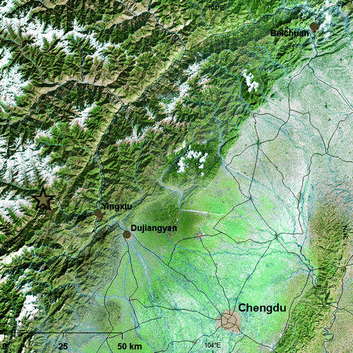
The Wenchuan magnitude 8.0 earthquake unleashed its devastating energy on 12 May 2008 causing damage to physical infrastructure and resulting in more than 69 000 casualties as reported by the Chinese government (Citation2008). The earthquake occurred as the result of motion on a northeast striking reverse or thrust fault on the northwestern margin of the Sichuan Basin (). It reflects tectonic stress resulting from the convergence of crustal material moving slowly from the high Tibetan Plateau to the west, and strong crust which underlies the Sichuan Basin and southeastern China. Previous destructive earthquakes in the Sichuan province include the 1933 magnitude 7.5 earthquake, with more than 9300 reported dead by the United States Geological Survey (USGS).
Figure 1. Earthquake-affected area of the Sichuan province north of Chengdu. The location of the epicentre (star) as well as the three towns included in the study are shown.
The damage to the physical infrastructure results from the ground motion which is as a function of the depth of the earthquake of only 19 km, the magnitude of the earthquake of 8.0 on the Richter scale, and its duration of nearly two minutes. Most of the casualties are owing to physical injuries resulting from collapsing buildings, but casualties have also been reported as a result of landslides and rockfalls. Moreover, landslides have compromised access to mountain villages and have interrupted the flow of rivers. Inundations created by these natural dams are extremely dangerous for the villages downstream. Aftershocks, landslides, and water accumulation continued to be a threat for weeks after the main earthquake event.
3. Data
Satellite images of five different sensors, as discussed in detail below, have been collected over the Sichuan province and are used in the analysis.
The imagery was acquired by the optical sensors EROS-B, WorldView-1, and SPOT-5, and the radar (SAR) sensors CosmoSkymed and TerraSAR-X ().
Table 1. Imagery used for structural damage assessment in areas affected by the Sichuan earthquake.
Some of the spectral characteristics of optical satellite imagery are homologous to digital camera pictures. The system parameters of imagery provided by a number of high resolution optical satellite sensors are listed in . Imagery is made available either as a single ‘black and white’ panchromatic band which usually provides the highest spatial resolution. Additionally, multispectral channels in the visible or near-infrared portions of the electromagnetic spectrum are available from some sensors. These allow for the generation of natural or false colour composites, and pansharpened image products when integrated with a panchromatic band.
Table 2. Optical satellite imagery potentially useful for post-disaster damage assessment presented in the order of decreasing resolution. Imagery used in this study are given in italics.
VHR SAR imagery can be acquired using different acquisition parameters and delivered at different processing levels. Acquisition mode, viewing geometry, and system polarisation have to be carefully selected, guided by the task at hand. Processed to single-look complex (SLC) data, they provide the highest spatial and radiometric resolution and flexibility, but require experience and specialised software for generating an interpretable image product. At slightly reduced spatial and radiometric resolution, georeferenced 16 bit imagery, possibly multi-looked, can be used for visual interpretation with only minor post-processing such as contrast stretching or speckle-filtering.
The analyst thus has the option to choose from a number of data sources and acquisition parameters (spectral/frequency/polarisation) to compile image products for visual interpretation and quantitative analysis. To serve the stringent requirements of emergency response, the imagery used in post-disaster damage assessment has to be acquired as soon as possible after the disaster event. This, together with competing requests for satellite acquisition time, typically limits the choice of sensors. The focus is then to obtain data of the best spatial resolution possible.
Data preparation as discussed in this paper targets visual analysis only. Quantitative analysis and corresponding processing procedures are the focus of a complementary paper and are not discussed herein.
4. Processing
4.1 Pre-processing of optical data
Optical imagery is available as panchromatic channels and multi-spectral bands (). The images from the suppliers are typically pre-processed following two steps. Radiometric correction removes striping, image skew, and other sensor- and orbit-related artifacts. Images are then geometrically corrected to conform to a geodetic projection. For this exercise UTM projection, based on WGS84, was used, a projection often favoured for large scale studies. A final contrast-stretch makes the information content suitable for inspection by the human interpreter.
4.2 Pre-processing of SAR data
SAR data, depending on the processing level of the delivered product, may require extensive processing and specialised software to generate a ‘picture-like’ image. Aside from image formation and geo-referencing, several post-processing techniques can be applied to extract specific image information, depending on the technical specifications () and the objective of the analysis. For the newly available data – TerraSAR-X and CosmoSkymed some processing issues are still to be resolved.
Table 3. Images from satellite-borne synthetic aperture radar (SAR) sensors. Imagery used in this study are given in italics.
The TerraSAR-X spotlight scene used in this study was delivered as a geocoded ellipsoid corrected (GEC) amplitude image product in 16 bit Geotiff format. Since GEC products are geocoded using an average ellipsoid height instead of a DEM, positional inaccuracies can occur. A 70 m shift, observed in Dujiangyan for the TerraSAR-X product with respect to the EROS-B level 1B image, was corrected using tiepoints and a 1st order polynomial transformation.
The CosmoSkymed imagery was delivered in complex format and slant range geometry (SLC). It was processed in-house to a ground-range detected, geocoded image product in amplitude using SARScape®, a software package which is dedicated to advanced radar data processing. A manual georeferencing adjustment via tiepoints was performed to achieve precise co-referencing with the EROS-B optical imagery.
5. Image analysis for damage assessment
Damage assessment for emergency response will be performed using any type post-disaster imagery available in time. The most effective operational image analysis – the process of extracting the information from the imagery – remains visual interpretation. While operational damage assessments are predominantly conducted using aerial surveys, the research and international emergency response community has started to use VHR optical and SAR satellite imagery for this purpose.
Damage is any change to the physical infrastructure and to the land cover which has a negative impact on the functioning of communities and society. This paper focuses on damage to the physical infrastructure, in particular to the building stock and transport network. These constitute the most valuable societal assets. Damage assessment, as discussed in this paper, is thus based on detecting changes in the imagery.
Satellite image analysis for damage assessment, whether visual or automatic, is based on two assumptions. (1) The objects of interest can be resolved and enumerated and (2) the changes to that object can be uniquely identified in the post-disaster imagery. In this paper the changes under investigation are collapsed buildings and interruptions in the transportation network resulting from collapsed bridges or landslides which erode the transportation network or cover part of it.
The analysis is conducted by assessing damage either in post-disaster imagery alone, relying on unique patterns of destruction, and/or by analysing simultaneously pre- and post-disaster imagery performing a change detection analysis. In this second case, when assessing damage to buildings, the pre-disaster image is used to detect and quantify the built-up stock while the post-disaster data are used to detect changes that have occurred to the stock. Damage to infrastructure can then be quantified by assessing the changes in spectral and/or textural properties of pre-and post disaster imagery with respect to each identified building.
5.1 Post-disaster image analysis
The post-disaster qualitative image analysis relies on the interpretation skills of the image analyst. This section identifies examples from available sensors of the challenges at hand with the newly available images. Four geographical areas are analysed using the satellite imagery listed in . The damages are discussed for image chips collected over segments of the towns for which the comparison of sensors was deemed most effective.
5.1.1 Widespread damage in Yingxiu
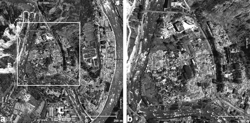
shows a WorldView-1 image collected over Yingxiu. The image provides an overview of the widespread damage, such as collapsed buildings. The image satisfies the first assumption for visual analysis; the objects of analysis can be identified and enumerated. The second assumption is also satisfied. The rubble associated with collapsed buildings can be identified; it is depicted as high-frequency textural changes in the WorldView-1 image (). Some seemingly intact buildings, however, may actually be structurally compromised but internal structural damage which does not result in major destruction to the topmost part of the buildings cannot be detected from satellite imagery as discussed herein. The resulting underestimation of the total damage is discussed below.
Figure 2. A 1×1 km2 subset of the city of Yingxiu as seen by WorldView-1 (a). The highlighted central area is enlarged in (b).
Yingxiu is also shown on a CosmoSkymed high-resolution stripmap image (3 m pixel spacing, (a)). For comparison a pre-disaster SPOT-5 panchromatic scene is included (2.5 m pixel spacing, (b)). The area enlarged in (b) shows a mixture of destroyed, severely damaged, and intact buildings. However, this distinction is not reflected in clearly visible radiometric or textural changes on the SAR imagery, which thus does not permit an unambiguous interpretation and damage assessment.
Figure 3. A comparison of CosmoSkymed SAR stripmap data at 3 m resolution (a) and SPOT-5 pre-disaster panchromatic imagery at 2.5 m pixel spacing (b) over Yingxiu.
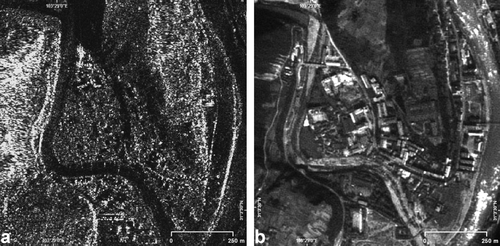
The intact building at the northern end of the enlarged area can be identified well by its large, linear backscatter signature. The SAR signatures of the standing buildings in the area are not very distinct from the surrounding rubble. This is likely owing to a combination of two effects. The buildings’ unfavourable aspect angle with respect to the SAR viewing geometry reflects most of the signal away from the receiving sensor. Additionally, the signal is attenuated by the rough-textured debris around the intact building. This reduces the corner reflection effect, associated with the wall-ground interaction of the signal, which would otherwise produce clearly identifiable bright, linear signatures (Xia and Henderson Citation1997, Matsuoka and Yamazaki Citation2003).
Optical imagery with a spatial resolution of 0.5 m×0.5 m such as available from WorldView-1 () provides the capability to identify buildings that have not collapsed. Rubble, associated with destroyed buildings, can also be clearly identified. Quantifying the ratio of destroyed buildings requires pre-disaster imagery in order to identify and enumerate the pre-disaster building stock. Post-disaster imagery then provides information on the number of buildings collapsed during the event.
5.1.2 Localised damage in Dujiangyan
The EROS-B scene covers an area of 1×1 km2 over Dujiangyan ((a)). The image satisfies the requirements of the visual interpreter and the image analysis assumptions. Individual buildings can be identified and collapsed buildings can be clearly detected. Compared to Yingxiu, the Dujiangyan image shows less damage. Several buildings have collapsed but these buildings are only a fraction of the total built-up stock. Also, no particular pattern of destruction can be identified.
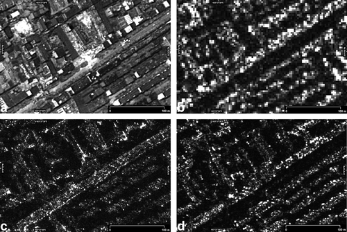
Figure 4. Image examples over Dujiangyan acquired by EROS-B (a), CosmoSkymed stripmap (b), CosmoSkymed spotlight (c), and TerraSAR-X spotlight (d). The subset outlined in (a) is presented enlarged in .
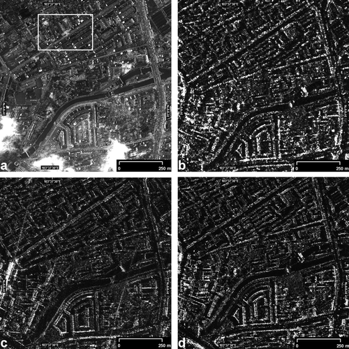
shows, in addition to the optical EROS-B image chip (a), images from CosmoSkymed and TerraSAR-X in stripmap (b) and spotlight (c, d) mode. Within the 1 km2 area a 200×300 m area (red frame -(a)) over a damaged building is shown enlarged in . The damage, which can be clearly seen on the EROS-B image chip could be identified by an expert SAR image analyst also on the TerraSAR-X and CosmoSkymed spotlight imagery (c, d). This TerraSAR-X regular spotlight image (4d, 5d) with 150 MHz processed range bandwidth (‘SL150’) and resulting 1.6 m ground range resolution, however, does not represent the optimum image quality achievable with the sensor. High-resolution spotlight imagery with 300 MHz processed range bandwidth (‘HS300’), processed to a spatially enhanced product (‘SE’) at 1 m spatial resolution, is required for analyses at the individual building level. Identification of the damage on the CosmoSkymed stripmap image (b), at approximately 3 m spatial resolution, also is not unambiguous. Without prior knowledge of potential damage it is unlikely that a SAR analyst would be able to identify with certainty the damages on the SAR images based solely on post-disaster imagery.
Figure 5. Enlarged subset of the image chips shown in . EROS-B (a), CosmoSkymed stripmap (b), CosmoSkymed spotlight (c), and TerraSAR-X spotlight (d). The damage to the building structure in the central area is well visible on the EROS-B image (a). To a trained interpreter, textural deviations in comparison with intact buildings can serve as an indicator of damage on the spotlight SAR imagery (c, d).
Further processing of the SAR data, such as speckle-filtering or extracting textural or linear features, would likely facilitate the identification of damaged areas. However, for visual interpretation in rapid mapping scenarios, it is usually expected that an analyst should be able to see the damage in nearly untreated imagery.
5.2 Pre- and post-disaster change detection
If pre- and post-disaster imagery is available, damage may be quantified using change detection techniques. From multiple observations, change detection identifies differences in the state of a geographic feature over time (Singh Citation1989). Most change detection techniques are related to land cover change but do not specifically target built-up areas (Lu et al. Citation2004). Recently, automatic techniques for detecting change within the built-up area have been tested in Tsunami-affected regions (Pesaresi et al. Citation2007).
5.2.1 Land cover change
The damage to built-up structures can also be inferred by observing other changes in land cover. One of the most typical changes in land cover, induced by an earthquake and associated also with damage to buildings and infrastructure, is a landslide. Landslides often destroy roads or railroads, rendering surface transport impossible (). Landslides may generate natural dams which interrupt the flow of rivers. These dams can cause flooding upstream and inundate towns as shown in . They pose an additional hazard as the pressure of the inundated water may breach the dam at any time and cause devastating flooding downstream. Landslides descending on settlements () have claimed thousands of lives in Beichuan.
Figure 6. Landslides interrupting roads upstream from Beichuan depicted on a SPOT-5 panchromatic image.
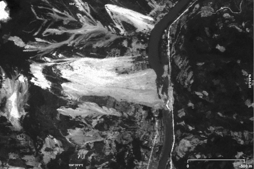
Figure 7. Inundated village as seen on a SPOT-5 panchromatic image.
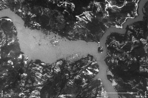
Figure 8. This figure shows the city of Beichuan on pre-disaster (a) and post-disaster (b) SPOT-5 imagery at 2.5 m resolution. Two large landslides (white arrows) have destroyed parts of the city.

5.2.2 Changes in built-up area
Pre-disaster SPOT panchromatic imagery over Beichuan clearly shows the built-up structures of the city ((a)). On the post-disaster SPOT image (b) collapsed buildings and two large landslides impinging on the city can be seen. Both assumptions are satisfied. The built-up structures are clearly visible and the change can be clearly identified.
A visual comparison of the two images is sufficient to assess the devastating damage which has occurred. Several buildings are still in place, but likely are structurally compromised. The post-disaster image alone suffices to identify the widespread damage. However, only in combination with the pre-disaster image, which provides the building stock, the percentage of built-up structures that have been destroyed – which either have collapsed or are covered by landslides – can be calculated.
The spatial and radiometric resolution of the SPOT sensor thus allows to detect collapsed buildings as well as landslides which have impacted the village on post-disaster imagery. Pre-disaster image data provide sufficient detail to quantify the pre-existing building stock and, in combination with post-disaster imagery, to calculate the relative damage.
5.2.3 Damage to the built-up stock
The most effective procedure to carry out damage assessment is using both pre- and post-disaster aerial or satellite imagery. The task is first to identify and enumerate the building stock, i.e. the number of buildings in the area, from the pre-disaster imagery. Collapsed buildings are then detected and counted using the post- disaster data. The result of such an analysis is illustrated in which shows a 1×1 km2 area of Yingxiu covered by panchromatic SPOT-5 and WorldView-1 imagery.
Figure 9. Pre-disaster SPOT-5 (a) and post-disaster WorldView-1 (b) imagery over Yingxiu. The green circles on both image chips represent detected intact buildings; those that were destroyed during the earthquake are marked with a red×on the post-disaster image. Intact buildings, identified on the post-disaster WorldView-1 data, but not present on the SPOT image, acquired in 2005, are depicted as light green triangles. The image is centred on 31°04′N, 103°29′E.
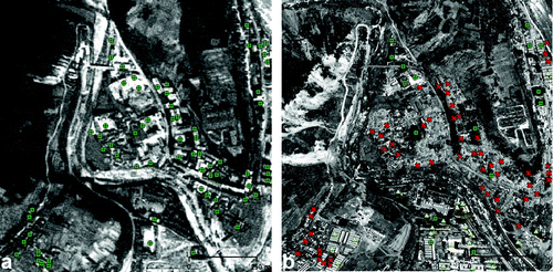
Pre-disaster SPOT-5 panchromatic imagery at 2.5 m spatial resolution was used because no finer resolution imagery was available over the area. Adjacent buildings, clearly separated on the WorldView-1 image, appear as one large structure on the SPOT-5 image chip and are counted accordingly. Small isolated buildings may not be depicted on the SPOT-5 data as a result of the limited spatial resolution. The analysis shows 52 building structures identified as collapsed on the post-disaster WorldView-1 image while 14 structures are still standing. The comparison of the two scenes also shows 24 intact buildings, which have been constructed after the collection of the SPOT-5 imagery in 2005. Some of those buildings may have collapsed, but an accurate enumeration is challenging since the analyst has to rely on the post-disaster imagery alone, without a precise count of existing buildings provided by a recent pre-disaster image.
The number of collapsed buildings over the building stock provides the collapse ratio. The ratio of collapsed buildings is a critical measure in rescue operations since collapsing buildings claim the majority of lives during an earthquake.
6. Discussion
Very high-resolution post-disaster optical satellite imagery, when not influenced by clouds or other atmospheric effects, is effective in identifying collapsed buildings. The reliability of the interpretation increases with spatial resolution. Spatial resolutions of 1 m or better, as available from WorldView-1 and EROS-B, are very effective. SPOT-5 panchromatic imagery at 2.5 m resolution is also useful even though the detectability of individual structures is somewhat reduced owing to the lower spatial resolution. On post-disaster imagery of spatial resolutions lower than 2.5 m, the rubble of collapsed buildings tends to be depicted on the image as textures which are easily confused with other patterns, such as those of temporary shelters. These image data are therefore not deemed appropriate for damage assessment.
The ambiguities encountered during the analysis of pre-disaster SPOT-5 (2.5 m) and post-disaster World-View-1 (0.5 m) panchromatic data demonstrate that for damage assessment at the building level, both pre-disaster and post-disaster imagery should have spatial resolutions of better than 1 m. Only then can an accurate building enumeration be performed. Coarser resolution imagery, such as the SPOT-5 data shown in , dramatically decreases the accuracy of the assessment.
This study has shown that even on the highest resolution SAR image products available, collapsed buildings might not be detectable visually. Further processing of the SAR data, beyond the mere image product, are required to take full advantage of damage-related information contained therein. Speckle-filtering, while being a useful image enhancement technique for visual interpretation, can destroy subtle relevant image textures and has to be used with care. Determining optimum processing methods is still subject to further investigation. In a multi-sensor approach, optical pre-disaster or post-disaster imagery can provide an indication of damage and can be used in combination with radar images. However, experienced interpreters are required to unambiguously identify damage to built-up structures from SAR imagery.
SAR imagery must also be available at the highest resolution possible. ‘Enhanced spotlight’ mode is recommended for CosmoSkymed data. For TerraSAR-X the highest resolution imagery is provided by the ‘high-resolution spotlight’ mode at 300 MHz processed range bandwidth (‘HS300’). If ordered as a georeferenced product, the data should be processed to ‘spatially enhanced’ (SE) imagery. Large incidence angles should be favoured to increase the target-to-clutter ratio, which facilitates the distinction between coarse debris and standing buildings. However, large incidence angles produce extended shadows which might obscure important parts of the area of interest. This effect is particularly detrimental in steep, mountainous areas, or in cities where tall buildings stand close to each other. HH polarisation is usually preferred for urban targets (Aoki et al. Citation1999).
Typical high-resolution optical and SAR image frames, which vary from 5×5 km2 to 16×16 km2, are large enough to cover an entire town. Increased area coverage can be obtained easily along the satellite orbital direction.
SPOT-5 panchromatic imagery, which combines adequate spatial resolution with large area coverage, is effective for identifying land cover changes. Changes in land cover, combined with pre-existing information layers, such as the road network and settlements, can be used to issue alerts for damaged infrastructure. Similarly, SAR imagery in fine-resolution modes can detect land cover change. Post-disaster VHR data in combination with pre-disaster imagery provides a more reliable interpretation than post-disaster imagery alone. This approach also allows to estimate the percentage of collapsed buildings. Pre-disaster data provide the stock of existing buildings, while post-disaster imagery is used to map the damage which occurred to the built-up stock.
Structural damage, not associated with a displacement or collapse of the building, can hardly be detected on VHR satellite imagery. Buildings which appear intact on the post-disaster image may still be structurally compromised and may require demolition. This, however, can only be assessed from field surveys.
Thus, damage assessment from remotely sensed imagery inevitably underestimates the total damage, which includes destroyed as well as structurally damaged structures. Damage assessment from satellite imagery, however, is a valuable tool in assessing the severity of the damage to the building stock and the geographical extent of the damage.
7. Conclusions
Earthquake related emergency response is typically conducted with the support of imagery providing information on the location and severity of the damage. Collapsed buildings, identified on the imagery, give an indication of the number of potential casualties. The count of collapsed buildings is often related directly to the number of casualties. Identified damage to the transport infrastructure provides an assessment of accessibility of the disaster site. Both factors, potential casualties and accessibility, are critical in organising targeted search and rescue operations as well as for general emergency response.
Aerial photography with spatial resolution of 0.5 m or better has shown to be a very effective tool for damage assessment. If acquisition is possible it is likely to remain the data source of choice for damage assessment. It allows for precise detection and enumeration of buildings-from pre- and post-disaster imagery. The large volume of imagery generated from aerial survey, however, is challenging in terms of data handling and visual analysis for the photo-interpretation team.
Satellite imagery is particularly useful when aerial photography cannot be acquired. In the case of the Sichuan earthquake bad weather had delayed the airphoto acquisitions for several days. Optical post-disaster VHR satellite imagery of resolutions of 1 m and higher can be used to unambiguously identify collapsed buildings.
SAR imagery is of specific interest when cloud cover hampers the acquisition of optical imagery. TerraSAR-X and CosmoSkymed data have been made available immediately following the earthquake but the data could not be exploited in time to be of operational use. Visual interpretation of the SAR data could not make full use of the information content of the imagery. A lack of pre-event VHR SAR satellite data prevented SAR-based change detection analyses.
The effectiveness of Earth observation for emergency response is related to satellite revisit times and resolving power of the imagery. Most VHR satellites have a pointing capability, which further decreases the revisit time. Satellite constellations, such as the CosmoSkymed mission, consisting of several similar sensors in different orbits, fulfil the same purpose. Currently, orbit spacing and cloud cover still prevent reliable daily coverage in large parts of the world, which, however, is a requirement for operational emergency response. SAR imagery is not affected by cloud cover, but the information content of the new VHR SAR image products with respect to damage assessment at the individual building level is still being investigated.
Satellite imagery can also be used effectively to develop datasets for disaster preparedness. The inventory of buildings is derived and quantified using VHR satellite imagery and integrated with information on building typology, construction standards, and infrastructure for an assessment of the built-up stock and its vulnerability. As proposed by CEOS (Citation2001), and following procedures used in disaster risk assessment, damage assessment models can combine this information with expected earthquake magnitudes to estimate the potential damage over a given area.
In case of an earthquake or any other natural disaster, the availability of preparedness datasets allows for an estimate of location and magnitude of potential damage and casualties. This information can be used for precisely dispatching rescue teams and thus precious time will be gained for saving lives. The authors suggest that until improvements are achieved in the temporal and spatial coverage in VHR optical and SAR imagery, more attention should be paid to technologies and methodologies for developing infrastructure-related spatial datasets for disaster preparedness to improve the efficiency of operational emergency response.
Notes on contributors
Daniele Ehrlich received his Ph.D. degree (1992) in Geography from the University of California, Santa Barbara, USA. He worked as a post-doc at USGS Sioux Falls and as remote sensing consultant in Southern California. In 1994 he joined the Joint Research Centre (JRC) of the European Commission, and is now a Scientific Technical Officer with the JRC. In 1999 he started activities on geo-spatial data in support of the humanitarian community with a focus on damage assessment. In his scientific and professional career he has used optical Earth Observation data for crop area estimates, tropical deforestation assessments, continental land cover change mapping, population estimates, and - more recently - for disaster risk and human security applications.
Huadong Guo is a Professor of the Center for Earth Observation and Digital Earth, Chinese Academy of Sciences. He is currently a Principal Scientist for a project on “Remote Sensing for Wenchuan Earthquake Disaster Mitigation, Chinese Academy of Sciences”, and was a Principle Investigator for more than 20 key national projects or programs in China, also PI for over 10 international remote sensing projects. He has published over 200 papers, and 12 books.
Katrin Molch received her Master degree (1997) in Geography from the University of Freiburg, Germany, with a focus on Remote Sensing and GIS. From 1997-2000 she worked as a consultant for the remote sensing industry in Germany and Canada and has contributed to a number of research projects on urban area classification from high-resolution SAR and InSAR data. As a research associate with the Canada Centre for Remote Sensing (2000–2006), Mrs. Molch developed SAR and InSAR applications for geological risk assessments. Since 2006 she is a scientific / technical project officer with the Joint Research Centre of the European Commission where she contributes to the development of SAR data exploitation methodologies for urban applications.
Jianwen Ma received his Ph.D. degree from Chendu University of Technology in Sichuan in 1998, and Remote sensing application certification in 1991 from University of Ottawa and Canada Center of Remote Sensing. He specialises in digital image processing, change detection and method development. His current research interests include pixel adjacent correction, multi-feature dynamic change detection using remote sensing data.
Martino Pesaresi graduated in Town and Regional Planning (IUA Venice 1991–1992). Mr. Pesaresi pursued research involving the use of remotely sensed data for urban analysis with the Centre d'Analyse et de Mathématique Sociale, Paris, with the Laboratoire d'Informatique Appliquée of the ORSTOM, Paris, and for the University of Venice (1991–1995). From 1992–1997 he consulted public and private institutes involved in town and regional planning. He held a research contract with the Joint Research Centre of the European Commission (EC JRC) from 1997–2000. From 2001–2004 he worked as section leader in the mapping industry in Italy. Joining the EC JRC Institute for Protection and Security of the Citizen in 2004, he now leads the “ISFEREA” team addressing Geoinformation Analysis for Global Security and Stability.
Related Research Data
References
- Adams , B. , Huyck , C. , Mansouri , B. , Eguchi , R. and Shinozuka , M. 2004 . “ Application of High-Resolution optical satellite imagery for post-earthquake damage assessment: the 2003 Boumerdes (Algeria) and Bam (Iran) Earthquakes ” . In Research Progress and Accomplishments 2003–2004 , Edited by: Bruneau , M. 173 – 186 . Buffalo : MCEER .
- Andre , G. , Chiroiu , L. , Mering , C. , Chopin , F. , 2003 . Building destruction and damage assessment after earthquake using high resolution optical sensors: The case of the Gujarat earthquake of January 26, 2001 . Proceedings IGARSS '03, 21–25 July 2003 , Toulouse, , France , 4 2398 2400 .
- Aoki , H. , Matsuoka , M. , Yamazaki , F. , Uratsuka , S. , Kobayashi , T. , and Satake , M. 1999 . Backscattering characteristics of airborne SAR images for seismic vulnerability assessment in urban areas . Proceedings ACRS ‘99 , 22–25 November , Hong Kong .
- CEOS , 2001 . Earthquake team report , [online] . CEOS Disaster management Support Group . Available from: http://www.ceos.org/pages/DMSG/2001Ceos/Reports/earthquake.html [Accessed 29 September 2008 ]
- Chinese Government's Official Web Portal , 2008 . China publishes identities of 19,000 dead in May quake , [online]. Available from: http://english.gov.cn/2008-11/21/content_1156146.htm [Accessed 8 January 2009 ]
- Hoffmann , J. 2007 . Mapping damage during the Bam (Iran) earthquake using interferometric coherence . International Journal of Remote Sensing , 28 ( 5–6 ) : 1199 – 1216 .
- Lu , D. , Mausel , P. , Brondizio , E. and Moran , E. 2004 . Change detection techniques . International Journal of Remote Sensing , 25 ( 12 ) : 2365 – 2407 .
- Matsuoka , M. and Yamazaki , F. , 2003 . Building damage detection using satellite SAR intensity images for the 2003 Algeria and Iran earthquakes . Proceedings IGARSS '03 , 21–25 July 2003 , Toulouse, , France . 1099 1102 .
- Pesaresi , M. , Gerhardinger , A. and Haag , F. 2007 . Rapid damage assessment of built-up structures using VHR satellite data in tsunami-affected areas . International Journal of Remote Sensing , 28 ( 13–14 ) : 3013 – 3036 .
- Sairto , K. , R. Spence , M. EERI , and T. A de C Foley , 2005 . Visual damage assessment using high resolution satellite images following the 2003 Bam, Iran, Earthquake . Earthquake Spectra , 21 S1 , 309 318 .
- Sertel , E. , Kaya , S. , Curran , P.J. , 2007 . The use of geostatistical methods to identify severe earthquake damage in an urban area . Proceedings Urban Remote Sensing Joint Event , 11–13 April 2007 Paris . 1 5 .
- Singh , A. 1989 . Digital change detection techniques using remotely sensed data . International Journal of Remote Sensing , 10 ( 6 ) : 989 – 1003 .
- Turker , M. and Cetinkaya , B. 2005 . Automatic detection of earthquake-damaged buildings using DEMs created from pre- and post-earthquake stereo aerial photographs . International Journal of Remote Sensing , 26 ( 4 ) : 823 – 832 .
- Turker , M. and Sumer , E. 2008 . Building-based damage detection due to earthquake using the watershed segmentation of the post-event aerial images . International Journal of Remote Sensing , 29 ( 11 ) : 3073 – 3089 .
- Xia , Z. and Henderson , F.M. 1997 . Understanding the relationships between radar response patterns and the bio- and geophysical parameters of urban areas . IEEE Transactions on Geoscience and Remote Sensing , 35 ( 1 ) : 93 – 101 .