Abstract
Urban growth boundary (UGB) is a regulatory measure of local government for delineating limits of urban growth over a period of time. Land within the UGB allows urban development, while the land outside of this boundary remains primarily non-urban. The increasing popularity of UGB demands an easy and effective method to design this boundary. This article introduces a new concept, Ideal Urban Radial Proximity (IURP), to designate a spatial UGB using geoinformatics in the digital environment. The Kolkata urban agglomeration was considered to demonstrate this model. Remotely sensed imageries of three temporal instants (years 1975, 1990 and 2005) were considered to determine the information on urban extent and growth of the city. These data were then used as inputs to model the UGB for the years 2020 and 2035. The proposed model discourages scattered development and increase in urban growth rate. It preserves urban vegetation, water bodies and any other important non-urban areas within the inner city space. The IURP concept will also be useful to make the cities circular and polycentric urban blobs into a monocentric tract. Apart from the proposed model and derived results, this research also proves the potential of geoinformatics in modelling a UGB.
1. Introduction
Urbanisation is a form of metropolitan growth that is a response to often bewildering sets of economic, social, and political forces and to the physical geography of an area, through which, the productive agricultural lands, forests, surface water bodies and groundwater prospects are being irretrievably lost (Pathan et al. Citation1989, 1991). Some of the causes of urban expansion include population growth, economic growth, industrialisation, patterns of infrastructure initiatives such as construction of roads and provision of infrastructure encouraging development. The direct implication of such urban expansion is the change in land-use and land-cover of the region (Maktav and Erber Citation2005).
Rapid urbanisation in the world is quite alarming (UNFPA Citation2007), especially in developing countries such as India. In India, unprecedented population growth coupled with unplanned developmental activities has resulted in rapid urbanisation (Mauser et al. Citation2006). According to the United Nations (UNFPA Citation2007), the urban population of Africa and Asia is expected to double between 2000 and 2030. India and other developing countries of these continents, therefore, will experience a high growth of urban population. This huge growth in urban population, coupled with several other factors as mentioned earlier, will force uncontrolled urban growth. One of the biggest challenges for science, engineering and technology in the 21st century is how to control this growth towards the protection of natural resources and the urban ecosystem.
1.1 Restricting urban growth
Several theoretical models to practical attempts and their evaluations can be seen towards the control of urban growth (e.g. Cooley and La Civita Citation1982, Easley Citation1992, Engle et al. Citation1992, Hannah et al. Citation1993, Helsley and Strange Citation1995, Sakashita Citation1995, Brueckner and Lai Citation1996, Sasaki Citation1998, Ding et al. Citation1999, Fodor Citation1999, Staley et al. Citation1999). The main question is how effective are the varied tools that have been developed and implemented in many places, in protecting open space in general and farmland in particular from conversion to urban development? Alterman (Citation1997), who compared the lessons learned in six nations, came to the conclusion that the effectiveness of most tools was moderate at best, as they cannot provide a solution to the problems facing agriculture vis-á-vis development pressures and decreasing profits. However, interestingly nonetheless, even those who vigorously criticise restraining policy do support its implementation in order to prevent urban sprawl and reduce the conversion of open space and farmland (Frenkel Citation2004).
Frenkel (Citation2004) has reviewed several existing tools for the control of urban growth and sprawl. Among the physical tools that were developed in order to restrain the conversion of farmland, one effective device is exclusive agriculture zoning (Coughlin Citation1991), which Oregon and Hawaii apply through statewide control. Alterman (Citation1997) found that the most common tool across the United States (US) was the nonexclusive zone which is much more flexible than agricultural zoning. Zoning may also include physical restrictions in dictating the land-use pattern in order to protect agricultural land (Hadly Citation2000). The idea of green belts (Longley et al. Citation1992), adopted mostly in Britain, though also found in other countries, is another popular means of setting limits to city expansion.
Annexation is another means of protecting agricultural land, by preventing open-space annexation to the city (for more discussion see Alterman Citation1997). Transfer of development rights could be a well-targeted tool. It is based on the separation of the development rights of land from its ownership, thus enabling the transfer of these rights from the place where development is undesirable to other more preferable and suitable places (shown by Juergensmeyer Citation1984–85, Anderson Citation1999, English and Hoffman Citation2001). Infrastructure concurrency requirements are recognised mostly in the progressive legislation adopted by Florida; it enables the local authority to determine the location and the timing of development in accordance with the timing of infrastructure development (for more discussion see DeGrove and Deborah Citation1992).
Some of the tools gathered from adequate public facilities ordinances basically support the justification of transferring the financial burden of public services to the new initiatives. According to Pendall (Citation1999), this type of ordinance constitutes one of the most effective tools in restraining urban sprawl. Other forms of intervention have developed from this concept, among which are the following: conservation easements voluntarily transferring development rights to unprofitable organisation or funds in exchange for gaining tax rebates and easements; purchase of development rights (PDR), another kind of conservation easement. In this latter case, landowners sell their rights to develop land to the municipality for a limited number of years (Hadly Citation2000). A similar means that has recently been proposed is the mitigation ordinance. The initiator is forced to preserve a certain amount of its land in its natural condition against any amount of land to be converted for development (discussed by English and Hoffman Citation2001). More direct is land purchase by the government in order to preserve open space and farmland; this has been done, particularly in Oregon and Maryland, but in New Jersey, Florida, Pennsylvania, Arizona, Colorado and California as well (discussed by Hollis and Fulton Citation2002). Limited public funds are the major obstacle to a large operation of this tool.
Another important tool regarded as a means of targeting development and implemented in the US under the growth-management framework is the urban growth boundary (UGB), which is widespread at the city level (e.g. Anderson Citation1999, Burby et al. Citation2001) and has been adopted widely as a planning instrument (discussed by Schiffman Citation1999) within a metropolitan or regional physical plan; e.g. in Oregon and Minneapolis in the US, Melbourne in Australia, Santiago in Chile, and also in Israel amongst others (Nelson and Moore Citation1993, Asif and Shachar Citation1999, Pendall et al. Citation2002, Wassmer Citation2002, MSP Citation2003). Staley et al. (Citation1999) say that UGB is ‘one of the hottest planning tools’.
1.2 Urban growth boundary
UGB is a spatial boundary that controls urban expansion so that the land inside the boundary supports urban development and areas determined to remain non-urban outside the boundary. As urban development approaches the boundary, the boundary can then be thoughtfully extended for another time period, providing a stable manner in which land is transferred from rural to urban uses. It is important to realise that UGB differs from urban-service area (Easley Citation1992). Service areas are determined (theoretically) by objective information about a local government's costs to extend roads, water and sewer lines, or other public services. UGBs are explicit attempts to channel growth for broader political purposes and goals. In principle, a service area can change if improved efficiencies in service provision allow for the expansion of the region it serves, or natural market forces increase densities to the level where their extension is cost effective. Service areas also do not foreclose alternative forms of development. UGBs, in contrast, attempt to place some land off limits to development irrespective of public-service costs and efficiencies. Development will be discouraged or even prohibited beyond the boundary (if legally possible), even when services are privately provided (Staley et al. Citation1999).
Cho et al. (Citation2008) define the UGB as ‘a regional boundary designed to control the pattern of urbanisation (the development of areas for housing, commercial and industrial purposes) by designating the area inside the boundary for high-density urban development and the area outside the boundary for low-density rural development’. UGBs are established to promote compact and contiguous development patterns that can be efficiently served by public services. They are generally promoted to (1) preserve open space and farmland; (2) reduce infrastructure costs by encouraging urban revitalisation, infill and compact development; (3) clearly separate urban and rural uses; (4) ensure the orderly transition of land from rural to urban uses; (5) promote a sense of unified community; and (6) increase social welfare and economic efficiency within a given planning horizon. The primary intent of the UGB is to stem urban sprawl or outward expansion of a city and increase land-use efficiency. Staley et al. (Citation1999) and Ding et al. (Citation1999) documented several purposes and advantages of UGB in greater detail.
Empirical evidence on the impact of UGBs on development, however, is mixed. Some studies suggest that UGBs have effectively slowed down sprawling development (e.g. Nelson et al. Citation1997, Kline and Alig Citation1999, Patterson Citation1999, Brueckner Citation2000, Citation2001, Kline Citation2005, Cho et al. Citation2006). Other studies found that UGBs have no impact on growth (e.g. Staley et al. Citation1999, Jun Citation2004, Cho et al. Citation2007). In their analysis of Knoxville's UGB, Cho and Yen (Citation2007) found that the impacts of UGB on growth are conditional upon parcel location in urban or suburban areas. They suggested that the UGB slowed the pace of development in urban areas, but accelerated development in areas of rural–urban interface. Brueckner (Citation2007) evaluates the efficacy of UGB as a second-best substitute for a first-best toll regime in a congested city. By evaluating several cases, Staley et al. (Citation1999) concluded that UGBs may serve as political vehicles for claiming to preserve the physical character of the community, rather than as a dynamic growth-management tool tied to a progressive, evolutionary vision of the community.
The merits of UGB are often compared with development fees – another popular tool to control the urban growth. Brueckner (Citation2001) argues that setting the correct UGB is inherently more difficult than setting the appropriate development fee; whereas the former requires knowledge of all market conditions – the externality, land demand, supply and growth rates – the latter only requires knowledge of the externality. Turnbull (Citation2004) argues that as taxes or quantity restrictions are equivalent in a static world, the effects of any growth boundary can be replicated by an appropriately designed development fee and vice versa. In principle, a government can impose either the efficient development fee or a UGB, with its choice of policy reflecting distributive effects or pursuing the regulation with the lowest imposition or enforcement costs. But, one argument commonly levelled against development fees is that local governments rarely set such fees with regard to identified externalities in practice, instead of using such fees as simply another source of local revenue. Therefore, UGB is a more acceptable approach than the development fees.
Turnbull (Citation2004) shows that in the long run, UGB is very effective to decrease the supply of developable land. The American Planning Association recommends that UGBs be established ‘to promote compact and contiguous development patterns that can be efficiently served by public services and to preserve or protect open space, agricultural land and environmentally sensitive areas’ (APA Citation1997). In many instances, planning provisions that limit development through state or local ordinances are accompanied by growth boundaries. The importance of UGB, thus, still remains; although some of the empirical researches may not find this as a first-best method of urban planning. Despite several criticisms by Staley et al. (Citation1999), they state that more than 100 cities and counties have adopted some form of a UGB and the popularity of UGB is increasing. The importance of UGB cannot be disregarded owing to its many advantages. Clear and consistent direction about the future extent of a city is needed to give greater certainty for decision-makers, investors and the community and to reduce speculation. This need has been underlined in recent years for a more formal approach in defining an urban/non-urban boundary. In addition, the underlying goal of sustainable development supports the concept of a more defined edge to metropolitan growth and retaining rural values on the fringe of urban development (MSP Citation2003).
Despite their increasing popularity, UGBs have received little formal analysis (Ding et al. Citation1999). In the introduction to their review of empirical research, Knaap and Nelson (Citation1992) describe several ways in which UGBs could affect the land values. Cho (Citation1997) developed a model in which UGBs cause congestion externalities and flatten urban rent gradients. None of them, however, address how a UGB should be drawn or expanded. Lee and Fujita (Citation1997) derive the conditions for the efficient configuration of an urban greenbelt. Their greenbelt, however, is characterised as a multifunctional park which provides urban amenities but does not constrain urban growth. A number of empirical studies have examined the effects of UGBs and similar policy instruments on land values; some of which were reviewed by Fischel (Citation1991). Several recent studies (Mubarak Citation2004, Turnbull Citation2004, Brueckner Citation2007, Cho et al. Citation2008) have also examined the effects of UGBs from different points of view. Currently, however, there is no consensus on where the UGBs should be drawn spatially. Furthermore, there is no such universally accepted model(s) as well to designate a UGB. Ding et al. (Citation1999) propose several theoretical models of UGB as a function of social welfare. However, their models ignore many salient features of the urban landscape that planners must consider when designing actual UGBs; for example, the supply and location of exceptionally productive farmland, forests and other natural resources; the location and network structure of water (e.g. canals) and pattern/extent of urban infrastructure. Turnbull (Citation2004) also demonstrates several models to investigate how development fees and UGBs affect the urban development. However, his article is mainly focused on the comparison between development fees and UGBs rather than designating a UGB for the future. The review of literature by Staley et al. (Citation1999) found that most of the UGBs have been designed on the foundations of the urban growth model or urban land-use model in addition to the government policies and political geography of the region.
1.3 Urban growth control in developing countries
Urban growth control needs more attention in the developing countries than the developed countries. This is because, in the developed countries the future urban growth will be comparatively modest as their population growth rates are low and over 80% of their population already live in urban areas (UNFPA Citation2007). In contrast, developing countries, such as India, are in the middle of the transition process, when urban population growth rates are very high. Urban growth rate is also very high in these areas which are often sprawling with a high degree of freedom (Almeida et al. Citation2005, Angel et al. Citation2005). However, although a lot of evidence of urban growth control implementation can be given from the developed countries, no such significant attempt can be seen in the developing countries, especially in India.
UGBs are expected to be more effective than any other method of restricting urban growth in developing nations. Expansion of cities in developing countries cannot be restricted by implementing urban service area; rather the UGB is more stringent; because in many instances, urban growth is occurring at a high rate despite insufficient urban facilities. Furthermore, these cities generally grow almost without prior city planning; they lack future town-planning schemes and even lack current land-use/land-cover maps. UGB policies can control such unplanned growth of the city and it can regulate the planning policies within the defined sharp boundary. In the developing countries, enforcement is intermittent and often corrupt and property rights are not strictly enforced. This research assumes that a clearly defined edge to metropolitan growth may be more beneficial rather than the ‘first-best’ development-fee method that requires continuous, consistent and uncorrupted enforcement. It has also been assumed that UGB implementations in the cities of developing countries can equally serve the purpose as with the developed countries.
However, the case for densification and intensification by designating a UGB in the cities of developing countries should be treated separately to the developed countries. In the developing countries, urban densities are, on average, three times higher than the densities in industrialised and developed countries (Acioly and Davidson Citation1996, Angel et al. Citation2005) and a large part of the citizenry cannot afford minimum standard shelter. Therefore, further intensification may not be desired by the residents. This paper allows the existing urban density for modelling the UGB and assumes that there is no need to change this existing density.
1.4 Geoinformatics for modelling of UGB
In recent years, remote sensing and geographic information system (GIS) are widely used for mapping, monitoring and modelling the urban growth, land-use and sprawl. The physical expressions and patterns of sprawl on landscapes can be detected, mapped and analysed using remote sensing and GIS (Barnes et al. Citation2001). The geoinformatic decision-support systems evaluate geospatial datasets using multi-agent evaluation (Axtell and Epstein Citation1994, Parker et al. Citation2003) which can also predict the possibilities in the subsequent years using the current and historical data. In the last few decades, geoinformatic techniques have successfully been implemented to detect and model the urban growth dynamics, which have dealt with a diverse range of themes. According to Batty (Citation2000), there are currently some 20 or more applications of analytical and simulation models to cities, such as in the diffusion or migration of resident populations (Portugali et al. Citation1997), competitive location of economic activities (Benati Citation1997), joint expansion of urban surface and traffic network (Batty and Xie Citation1997), generic urban growth (Clarke et al. Citation1997) and urban land-use dynamics (Deadman et al. Citation1993, Batty and Xie Citation1994, Phipps and Langlois Citation1997, White and Engelen Citation1997), amongst others (Pathan et al. Citation1989,Citation1991, Acioly and Davidson Citation1996, Sudhira et al. Citation2004, Almeida et al. Citation2005, Angel et al. Citation2005, Kumar et al. Citation2007). Rule-based cellular automata have been increasingly applied to the simulation of urban phenomena. Many interesting cellular automata studies have been documented in the simulation of residential development (Deadman et al. Citation1993), landscape dynamics (Soares et al. Citation2002), urban expansion (Batty and Xie Citation1994, Clarke et al. Citation1997, Wu and Webster Citation1998) and land-use changes (White et al. Citation1998, Li and Yeh Citation2002). Therefore, there is a strong reliance on remote sensing and GIS for the simulation and modelling of urban growth. These spatial models in addition to the government policies and political geography of the region are often used to predict the future urban extent and UGB by using geoinformatic analytical tools.
However, in many instances, designating the UGB on the basis of spatial urban growth models is a complex approach as they require extensive inputs of data. Urban growth models simulate the future urban map or growth considering existing growth pattern trend; therefore, designating a UGB on the basis of an urban growth model is far less convincing as the purpose of modelling a UGB is to restrict the freedom of existing growth pattern/process and to regulate the existing growth within the UGB. Furthermore, UGBs designed in consideration of spatial urban growth model may leave the city as polycentric non-contiguous urban blobs rather than making it a monocentric contiguous shape. Polycentrism is the principle of organisation of a region around several political, social or financial centres. A region is said to be polycentric if it is distributed almost evenly among several centres in different parts of the region. Monocentrism, in contrast, is the organisation of a region's political, social or financial activities centred in a single part (generally the central business district) of the region (Arnott and McMillen Citation2006). Modern cities are mainly polycentric. Polycentric cities are the outcome of the urban development and they have several advantages, for example, reduce the traffic congestion at the city-centre, reduce the travel time as there are multiple city-centres and distribute the financial activities. The proposed UGB model describes a process, by which a polycentric urban region gradually becomes monocentric and circular. Apparently, it seems to be contradictory with the theory of urban development. Therefore, it is worth mentioning that the word ‘monocentric’, in this paper, defines a contiguous urban form but functionally the role of the minor centres does not disappear when the isolated urban blobs merge into one contiguous urban fabric. Needless to say, a monocentric circular urban shape has many advantages, such as, reduced cost for the development of infrastructure and facilities, reduced cost of transportation from the central business district to the periphery and increased environmental or ecological sustainability (by reducing the leapfrog or ribbon development).
1.5 Objectives of the study
The main objective of this study is to introduce a concept towards defining the UGB by using geoinformatics, which perhaps best fit for cities in developing countries. In this study, a new but simple concept, Ideal Urban Radial Proximity (IURP) is introduced to model the UGB. The city of Kolkata, one of the metropolitan cities in India, was considered to demonstrate the proposed model. It is worth mentioning that this research in no way aims to analyse or model or simulate the urban growth process or pattern as it can be seen in the earlier studies; rather it aims to demonstrate a simple geoinformatic approach to design a UGB to restrict the freedom of urban growth. An additional goal of this study is to interest the city administrators and planners to apply this model to other cities as well, especially in developing countries. This research also shows the potential of geoinformatics in modelling a UGB. It is important to mention that the Kolkata urban agglomeration was considered just to demonstrate the proposed model; the merits of such UGB instrument on this city, therefore, may be debated as it requires empirical evidence that are not within the purview of the research. The research is rather aimed to develop a model for designing a spatial UGB in a digital environment. This model is expected to be useful to encounter the threats of unplanned urban growth in view of the sustainability of our planet.
2. Study area
Kolkata (formerly Calcutta), a 300 years old city of India and the capital of West Bengal state, was considered as a study area to demonstrate this model. Kolkata city is located 154 km upstream from the Bay of Bengal. The core city is located at 22°33′N 88°20′E on the east bank of River Hooghly (Ganges Delta) at an elevation of approximate 9 m.
In recent years, an environmental rejuvenation has arrested the morbid decline of its environment, leading to a spurt in the city's growth. Like other large cities, Kolkata continues to struggle with urbanisation problems such as poverty, pollution and traffic congestion (Banerjee Citation2005). In 2001, the population of the Kolkata urban agglomeration stood at 13 million and this rose by about 8 million in comparison to the time of the first Census of independent India in 1951. The following years represent an immense accretion in human numbers of about 6 million in 1961, 7.4 million in 1971, 9.1 million in 1981, 11 million in 1991 and 13 million in 2001 (Banerjee Citation2005). Owing to the increasing pressure of population coupled with several other factors the Kolkata urban agglomeration is continuously expanding. However, no significant attempt has been made to restrict its growth, or to plan a UGB for this city. Owing to an increasing urban encroachment on land (Bhatta Citation2009) there is an urgent need to restrict the city in view of the environmental and ecological sustainability.
3. Data and methodology
The following 15 years interval temporal satellite imageries have been used to execute the study:
-
LANDSAT–MSS image (path 148, row 45) of 05 December 1975;
-
LANDSAT–TM image (path 138, row 44) of 14 November 1990;
-
IRS RESOURCESAT–1 LISS–III image (path 108, row 56) of 05 February 2005.
Table 1. Spectral details of the satellite imageries.
The images were obtained as standard product – that is, geometrically and radiometrically corrected. However, owing to the different standards and references used by the image supplying agencies, the overlay of the images does not match with considerable accuracy. To solve this problem, images were co-registered so that the overlay matches with sub-pixel accuracy. Nearest-neighbour resampling method was used to transform the images so that the original pixel value retains.
Images from different sensors have differences in their spatial resolution. One approach to encounter this problem is resampling the higher resolution images to match the resolution of the lower resolution image. But resampling of an image to change the pixel size either averages the neighbouring pixel values (in case of bi-linear or bi-cubic) or pixel dropout/duplication occurs (in case of nearest neighbour); in addition, spatial details also decrease (Bhatta Citation2008). Therefore, the images were kept without changing the pixel size despite of the varying accuracy levels of classification with the different spatial, spectral and radiometric resolution. This approach was preferred to retain the spatial detail and original pixel value.
Co-registered images were then classified using nonparametric feature-space classifier (ERDAS Citation1999) to extract the built-up area along with other impervious surfaces to determine the urban class. Feature-space classifier is useful for broad classification and provides a way to classify a class with a non-normal distribution, such as urban class (ERDAS Citation1999). Impervious surfaces are promoted as useful environmental indicators (Schueler Citation1994, Arnold and Gibbons Citation1996, Barnes et al. Citation2000) and one environmental condition that impervious surfaces clearly indicate is urbanisation (Barnes et al. Citation2001). It is worth mentioning that if the study is concerned only with urban growth – that is, only the classes of urban and non-urban use are under consideration, a simple binary classification of remotely sensed data is enough (Bhatta Citation2009). The classified images were then compared with the topographical maps, available land-use/land-cover maps of respective time period, previous knowledge and ground checks to assess the accuracy (Bhatta Citation2008). Topographical maps of 1:50000 scale (surveyed in 1975–76 by the Survey of India) were used to check the accuracy of classification for the image of 1975. Land-use map (1:25 000 scale) and land-cover map (1:50 000 scale) of year the 1990, published by National Atlas and Thematic Mapping Organization (India), were used to check the accuracy for the image of 1990. Results of previous studies (Bhatta Citation2009) and field sampling (by means of global navigation satellite system with 1 m accuracy) were used to check the accuracy of classification for the year 2005. Accuracy assessment was performed for a total of 200 pixels on each image; which shows an overall accuracy of 71% for 1975, 83% for 1990 and 81% for 2005. As a general rule, the level of accuracy obtainable in a remote sensing classification depends on diverse factors, such as the suitability of training sites, the size, shape, distribution and frequency of occurrence of individual areas assigned to each class which together determine the degree to which pixels are mixed, the sensor performance and resolution and the methods involved in classifying, method and accuracy of ground truthing and others. However, discussion on the accuracies considering the preceding factors is out of the scope of this research. The review of literature (Chen Citation2003, Ismail and Jusoff Citation2008) suggests for the acceptance of the achieved accuracies. It is worth mentioning that no guidance on minimum required level of accuracy by the local policy makers has been found in the existing literature which would be better to justify the acceptance of such accuracy limits.
The overlay of classified imageries () shows how the city is expanding. One can notice the increasing tendency of discontinuous development with time. This dispersed development can be restricted by introducing a UGB. While designating a UGB for Kolkata, as mentioned earlier, the current urban growth rate of the city was considered. The urban growth rate of the city can be calculated simply from the classified imageries by calculating the total built-up area within the city-extent of each temporal instant and then calculating the percentage of change in built-up areas between two successive temporal instants. It is worth mentioning that this growth rate of built-up areas has been calculated for 15-yearly period using the following formula:
where
C=built-up area within the city-extent
i=a specific temporal instant
i−1 = previous temporal instant of i
C i – C i−1=built-up growth between two temporal instants.
Built-up area means the area of urban (built-up and other impervious) pixels; whereas, city-extent means the boundary of the city defined by the extent of contiguous urban pixels. It is important to mention that the built-up area and city-extent are different. Built-up area considers the urban pixels only (), however, city-extent is a boundary which is defined by the contiguous urban land-cover class but it includes the non-urban islands within the contiguous urban tract (). Therefore, the area of city-extent will be much higher than the built-up area within this city-extent, especially, if it contains large non-urban islands within it.
Figure 1. Overlay of classified satellite imageries shows built-up areas of three temporal instants.
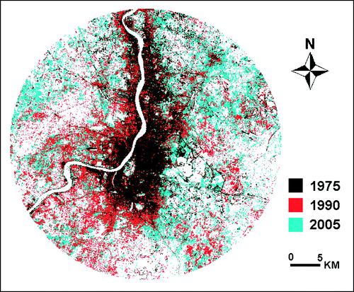
Figure 2. City-extent of three temporal instants.
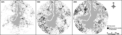
The extent of a city is a dynamic phenomenon. It changes over time; however, the political boundary of the city cannot be changed frequently owing to administrative complexities. In this study the extent of a city was considered as a dynamic phenomenon rather than the static political boundary. A neighbourhood search was conducted to derive the contiguous urban area (excluding River Hooghly) and this boundary was considered as the physical extent of the city for a temporal instant. The neighbourhood search determines which pixels will be considered contiguous to the seed (selected) pixel. Any neighbouring pixel that meets all selection criteria (in this case — belonging to built-up class) is accepted and thus, itself, becomes a seed pixel (ERDAS Citation1999). This has resulted in a contiguous area for each temporal instant. This contiguous area was considered as the temporal extent of the city (). Discontinuous or scattered built-up pixels, outside of this extent, were not included as they are generally considered as sprawl and problems to the sustainable development (Wilson et al. Citation2003). However, non-urban islands within the contiguous built-up pixels were included, because the intention was to demarcate the extent (boundary) of the city, not to find out the contiguous built-up pixels. Encouragement of urban growth within this extent will force infill growth as remedies to urban sprawl (Wilson et al. Citation2003).
In the next step, to get the status of urban growth, area of city-extent and built-up area within the city-extent (for each temporal instant) were calculated (). These values were then plotted in a chart () that illustrates the increasing trend in growth of the city-extent and built-up. Built-up growth rate and the rate of change in city extent have been calculated using Equation (Equation1) as furnished in . However, to calculate the rate of change in city extent, variable C should be considered as the area of city extent in Equation (Equation1). shows that the growth rate of built-up area during 1975–90 was 57.61 and during 1990–2005 it was 64.91. Therefore, the percentage of increase in the growth rate of built-up area remains 12.67. However, one can notice that the percentage of increase in growth rate of the city-extent is 18.17, which is larger than the percentage of increase in built-up growth rate (). This is an indication of urban sprawl. It may be mentioned that the percentage of increase in growth rate has been calculated as:
where
G j =rate of growth during 1990–2005
G j−1=rate of growth during 1975–90.
Now, to predict the built-up area for the years 2020 and 2035, the growth rate of built-up area during 1990–2005 () was considered without allowing any increase in growth rate. This approach considers the latest growth rate to support the development requirements but rejects the increase in growth rate for the sustainable development. A lower growth rate may also be considered, however, the existing growth rate is likely to maintain the existing urban densities (Acioly and Davidson Citation1996), which is one of the presumptions. If the same growth rate continues, the built-up area in 2020 will be 770.03 km2 and in 2035 it will be 1269.84 km2. shows the differences in the built-up area in the cases of consideration and non-consideration of increase in growth rate (i.e. 12.67%, from ).
Figure 3. The increasing trend of urban growth for Kolkata.
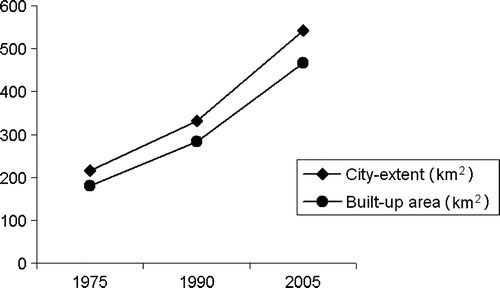
Table 2. Area of the city-extent and built-up area within the city extent (in km2).
Table 3. Trend of urban growth during 1975–2005.
Table 4. Predicted built-up area with and without consideration of observed increase in built-up growth rate (area in km2).
Now to draw the UGB, it has been considered that the ideal shape of a non-sprawling city is a circular city that is fully compact. Circles have a long tradition in urban geographic research. Using circles as a basic geometric shape that represents interacting factors or ranges of influence is also prevalent in contemporary urban geographic research (Herold et al. Citation2005). Furthermore, monocentric circular urban shape has many advantages. In this study, a new concept, IURP has been introduced to designate a UGB. IURP is a theoretical construct, which may be defined as a radial distance from the city-centre to define a circular area around it, within which the land is fully covered with built-up class and outside of which there is no existence or influence of this concentrated built-up area. The IURP for a city can be calculated by the following simple equation:
where
C i is the built-up area within the city-extent for a specific temporal instant.
According to this equation, the IURPs of 2020 and 2035 become 15.65 km and 20.10 km respectively. Now, the UGB for the year 2020 can be drawn with this IURP. If a circle with a radius of 15.65 km from the centre-point of the city is drawn, the resulting circle will represent the total built-up area for 2020 according to the theoretical concept of IURP. Needless to say, this is an oversimplified approach and it needs to be adjusted to overcome practical hurdles. Therefore, this IURP has been adjusted accordingly.
If the existing city-extent of the year 2005 is overlaid on the IURP circle of 2020, it shows the city-extent of the year 2020 (), which is ultimately larger than the projection because it also includes the existing city-extents outside of the drawn IURP. Furthermore, according to the definition of IURP, in an ideal case, the entire built-up class should fall inside of this proximity and outside of that should be covered with non-urban class(es). Practically, this consideration is not only impossible but also not desired for the health of the city. Urban land-cover can never be fully saturated within a radial distance from the city-centre. Therefore, the lands where urban development is not possible or permissible should be excluded. The areas, conversion of which may hamper the environment and ecosystem, should be ignored for urban uses; multi-cropped agricultural lands within the UGB should also be excluded. In this study, however, owing to non-availability of current land-use maps and the maps of restricted or disputed lands, only water bodies and some of the restricted areas well-known to the local people (e.g. stadium grounds, gardens of heritage buildings, lands owned by military, reserved botanical gardens, protected wetlands and large playgrounds of reputed clubs) were considered as non-developable land (). It is worth mentioning that ‘non-urban area’ and ‘non-developable area’ are different; because non-urban area includes both non-developable and developable lands.
Figure 4. Overlay of built-up pixels, non-developable land and city-extent of the year 2005 along with IURP and AIURP of the year 2020.
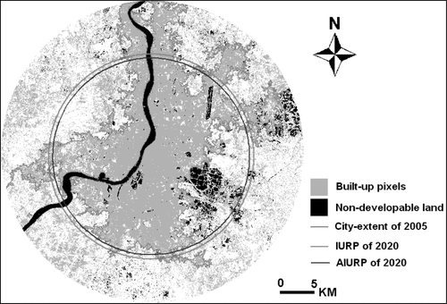
To solve the practical problems in designing the IURP, discussed in the preceding paragraph, non-developable land within the city-extent of 2005 was calculated as 8.35 km2 (). Therefore, within the city-extent of 2005, by implying a UGB for the year 2020, an area of 533.04 km2 should be urban (built-up). This has been obtained by: area of city-extent () minus non-developable area within this extent (). The projected built-up area of 2020 is 770.03 km2 (), out of which 533.04 km2 can be accommodated within the city-extent of the year 2005. Therefore, the difference between these values — that is, 236.99 km2 of future built-up area, is going to occupy the developable lands outside of the city-extent of 2005. Now, if a circular neighbourhood search is applied for developable pixels, from the city centre but outside of the city extent of 2005 until it hits the calculated difference (236.99 km2), the adjusted IURP (AIURP) for the year 2020 can be obtained (, ). In this study, the centre point of the city (referred to as city-centre) was considered at the central location of the central business district. The AIURP was generated using a manual iterative process by changing the radius of the circle; however, a computer program can automate this process. Now, merging the city-extent of the year 2005 with the AIURP circle of 2020, the UGB for the year 2020 can be obtained (). Needless to say, this UGB has been considered as the ‘city-extent’ of year 2020 for designing the UGB of 2035. It has also been considered that there will be no developable land within the UGB of 2020, as this will be fully developed during 2005–20 (). However, this may not be true if a lower growth rate is observed than the projected one. Now the AIURP for the year 2035 can also be designed with the same approach. The projected built-up area of 2035 is 1269.84 km2 (), out of which 770.03 km2 () will be accommodated within the city-extent of year 2020. Therefore, the difference between these values – that is, 499.81 km2 future built-up area will occupy the developable pixels outside the city-extent of 2020. Now, if a circular neighbourhood search is applied for developable pixels, from the city centre but outside of the city extent of the year 2020 until it hits the calculated difference (499.81 km2), the AIURP for the year 2035 can be obtained (). Now, merging the city-extent of the year 2020 with the AIURP circle of 2035, the UGB for the year 2035 can be obtained ().
Figure 5. UGBs of 2020 and 2035.
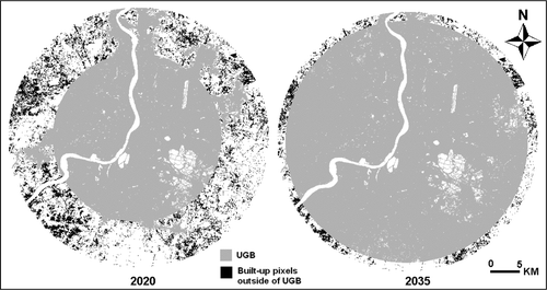
Table 5. City-extent; built-up area, non-developable land, and developable land within the city-extent (area in km2).
Table 6. IURP and AIURP for the years 2020 and 2035 (in km).
4. Discussion
In this study, the existing urban growth rate has been considered for designating a UGB that is likely to maintain the existing densities, which may be discouraged by some of the proponents. Rather, they may want to apply more restrictions on it desiring a higher density. However, it is worth mentioning that the concept of IURP is not constrained by the straitjacket of rigid theory devices; neither does it impose theoretical restraints on modelling a UGB. The IURP can be calculated using any magnitude of urban growth that has been obtained from any simulation model. The concept of IURP considers the ultimate future projection of a built-up area. It does not depend on how the growth is projected or modelled, or the simulated pattern of growth. Therefore, any suitable correction factor or model can be applied to project the future built-up area and accordingly the IURP can be calculated.
This study gives a simple idea of how to draw a UGB using geoinformatic techniques. Urban growth is a complex process and depends on several factors; however, consideration of growth-process, in defining the UGB, automatically includes these existing factors. Therefore it can be said that the proposed model is comprehensive. Although, it is worth mentioning that the proposed model ignores any future influence, e.g. unprecedented population growth rate, any future land-development policy, unprecedented economic growth, etc. Therefore, by using the demonstrated model, the UGB should not be designed for a future of more than 15 years. UGBs should be evaluated and revised time-to-time. The analysis of urban growth process, based on which the UGB is designed, should also be performed with high temporal resolution (e.g. five yearly); however, in this study cost prohibited purchase of imagery in smaller temporal gaps. This research designates the UGBs for the years 2020 and 2035 by analysing imagery of 15 yearly intervals which may not fit the practical implementation of the concept. Furthermore, there are only three temporal instants in the analysis, two gaps and so only one degree of freedom. Some additional imageries in shorter temporal gaps can provide better knowledge on the growth process that can help in predicting the future growth more efficiently; and ultimately can result in a more reliable UGB.
In this research, the UGBs for the city have been drawn for the years 2020 and 2035; however, from the preceding discussion, the UGB of 2035 should be revised after evaluating the situation of 2020. Needless to say, the actual urban extent of 2020 may not match exactly with the modelled UGB of 2020. It is worth mentioning, if the urban growth rate decreases during 2005–20, the UGB of 2035 may be revised considering the decreasing rate of growth. Therefore, the UGB of 2035 is an approximation only and no developmental initiative should be taken considering this UGB; rather this UGB should be treated as a conceptual growth boundary which is necessary to be validated and/or revised. However, this boundary may be very useful for the proponents to debate on the growth of the city and for mental preparation of the planners and other stakeholders for the future.
From , one may find that there is no significant difference in magnitudes between the IURP and AIURP. For the year 2020, the difference is only –0.69 km and for the year 2035 it is 1.23 km; both are very insignificant in the case of metropolitan cities. However, if the existing city-extent and the calculated IURP contain a huge non-developable land the AIURP will be increased by a high magnitude over the IURP. Similarly, if the city-extent and the calculated IURP contain a large amount of developable land then the AIURP will be decreased in a high magnitude over the IURP. Therefore, the UGB should be modelled in consideration of AIURP rather than the IURP.
It is also necessary to discuss another important issue — the extent of the study area. The extent of the study area should be large enough to contain the latest extent of the city and the modelled UGBs of the city. This may be difficult to determine at the beginning as the UGBs are the results of the analysis. Therefore, to be on the safe side, the study area should be considered at least two times larger (in radial distance from the city-centre) than the existing city-extent; and the images should be procured accordingly. The existing city-extent can roughly be determined by the visual inspection of the preview-image that is generally provided by the image supplying agencies before sale. The final maps can later be prepared by subsetting the unnecessary portions (if any) of the classified imageries, as it has been done in this study.
5. Conclusions
Adoption of the UGB will provide greater predictability in planning at local and regional levels, for governments and infrastructure providers and for investment by the private sectors. The UGB supports more orderly development of land, discourages the unnecessary extension of community infrastructure and helps in preserving the important qualities of rural areas. The demonstrated concept of designating the UGB should prove efficient control on urban growth and sprawl. The concept of AIURP supports existing growth rate, discourages scattered development and increase in growth rate; preserves urban vegetation, water and any important non-urban area within the inner city space; it considers all existing factors of influence on urban growth by accounting the existing growth process. The proposed concept of restricting urban growth, therefore, will promote compact and contiguous development patterns within a circular zone and preserve or protect open space, agricultural land and environmentally sensitive areas. Furthermore, this concept is simple, flexible and empirically devised. As this is an empirical approach, its applicability can be extended to further cities — in developing countries and worldwide – provided that the minimum necessary set of evidence maps are available.
The methodology also shows a simple approach of determining urban sprawl – if the percentage of increase in growth rate of the city-extent exceeds the percentage of increase in built-up growth rate, it is an indication of sprawl. The study also shows a geoinformatic approach to determine the dynamic boundary of the city (city-extent) considering the contiguous built-up pixels. Additionally, the result and discussion has directed attention to the magnitude and pattern of change in urban growth of Kolkata for the last three decades (1975–2005), that would be very helpful in terms of guiding future planning and policy-making for the city. However, there still remains some important policy issues for which analytical support has to be made available.
In summary, this study opened with an observation about the important role for geoinformatic techniques to model the UGB, proceeded to demonstrate a new simple model that accounts the urban growth process and the theory of urban growth. This model demonstrates a digital approach for restricting uncontrolled and unplanned urban growth towards the sustainability of the earth and its environment. The study also focuses the scope of research and application on growth boundary for the city planners and administrators.
Notes on contributor
The author is currently a Senior Systems Engineer in the Computer Aided Design Centre of Jadavpur University, Kolkata. He has a post graduate degree in Remote Sensing and GIS; and has more than 13 years of industrial, teaching and research experience in remote sensing, GNSS, and GIS. He has authored numerous research papers and articles in various journals and magazines. He has also authored two textbooks on Remote Sensing, GNSS, and GIS. In recent years he has been engaged with rigorous research on applications of geoinformatics in urban geographic studies.
Acknowledgements
The author wishes to acknowledge the Director, Computer Aided Design Centre, Jadavpur University, Kolkata for providing the necessary facilities to execute this study. The author is also grateful to Earth Science Data Interface, GLCF for providing free Landsat data.
Related Research Data
References
- Acioly , C.C. and Davidson , F. 1996 . Density in Urban Development . Building Issues , 8 ( 3 ) : 3 – 25 .
- Almeida , C.M. , Monteiro , A.M.V. , Mara , G. , Soares-Filho , B.S. , Cerqueira , G.C. , Pennachin , C.S.L. and Batty , M. 2005 . GIS and remote sensing as tools for the simulation of urban land-use change . International Journal of Remote Sensing , 26 ( 4 ) : 759 – 774 .
- Alterman , R. 1997 . The challenge of farmland preservation: lessons from a six-nation comparison . Journal of the American Planning Association , 63 ( 2 ) : 220 – 241 .
- Anderson , H.H. 1999 . Use and implementation of urban growth boundaries , Denver : Center for Regional and Neighborhood Action .
- Angel , S. , Sheppard , S.C. , Civco , D.L. , 2005 . The Dynamics of Global Urban Expansion . Washington, D.C : Transport and Urban Development Department, The World Bank , 200 .
- APA (American Planning Association) , 1997 . Growing Smart Legislative Guidebook: Model Statutes for Planning and Management of Change, Phase I interim edition , Chicago, IL : APA .
- Arnold , C.L. Jr and Gibbons , J.C. 1996 . Impervious surface coverage — the emergence of a key environmental indicator . Journal of the American Planning Association , 62 ( 2 ) : 243 – 258 .
- Arnott , R . and McMillen , D.P. , 2006 . A Companion to Urban Economics , Blackwell Publishing , 574 .
- Asif , S. and Shachar , A. , 1999 . LAND — national comprehensive outline scheme and principles for building and development document — NOS/35 . Interim Report — Summary of Stage A, Tel-Aviv (in Hebrew) .
- Axtell , R.L. and Epstein , J.M. , 1994 . Agent-based modelling: Understanding our creations . The Bulletin of the Santa Fe Institute , 28 – 32 .
- Banerjee , A. , 2005 . Population Growth, environment and development: some issues in sustainability of the mega city of Kolkata (Calcutta), West Bengal . In theProceedings of the National Seminar on Population Environment and Nexus , Population Environment Centre, IIPS, Deonar , Mumbai , 21 October . Available from : http://www.iipsenvis.nic.in/paper/fp_anuradhab.pdf [ Accessed 13 February 2008 ].
- Barnes , K.B. , Morgan III , J.M. , and Roberge , M.C. , 2000 . Impervious surfaces and the quality of natural and built environments . A white paper prepared for the project Chesapeake Bay From Space . Available from : www.Chesapeakebayfromspace.net [ Accessed 10 January 2007 ].
- Barnes , K.B. , Morgan III , J.M. , Roberge , M.C. , and Lowe , S. , 2001 . Sprawl development: Its patterns, consequences, and measurement . A white paper, Towson University. Available from : http://chesapeake.towson.edu/landscape/urbansprawl/download/Sprawl_white_paper.pdf [ Accessed 10 January 2007 ].
- Batty , M. and Xie , Y. 1994 . From cells to cities . Environment and Planning B , 21 : 31 – 48 .
- Batty , M. and Xie , Y. 1997 . Possible urban automata . Environment and Planning B , 24 : 175 – 192 .
- Batty , M. 2000 . “ GeoComputation using cellular automata ” . In Geocomputation , Edited by: Openshaw , S. and Abrahart , R.J. 95 – 126 . New York : Taylor & Francis .
- Benati , S. 1997 . A cellular automaton for the simulation of competitive location . Environment and Planning B , 24 : 205 – 218 .
- Bhatta , B. , 2008 . Remote Sensing and GIS . New Delhi : Oxford University Press 872 .
- Bhatta , B. , 2009 . Analysis of urban growth pattern using remote sensing and GIS: a case study of Kolkata, India . International Journal of Remote Sensing , in press .
- Brueckner , J.K. and Lai , F.C. 1996 . Urban growth with resident landowners . Regional Science and Urban Economics , 26 : 125 – 143 .
- Brueckner , J.K. 2000 . Urban sprawl: diagnosis and remedies . International Regional Science Review , 23 : 160 – 171 .
- Brueckner , J.K. 2001 . “ Urban sprawl: lessons from urban economics ” . In Brookings-Wharton Papers on Urban Affairs , Edited by: Gale , W.G. and Pack , J.R. 65 – 89 . Washington, DC : Brookings Institution .
- Brueckner , J.K. 2007 . Urban growth boundaries: An effective second-best remedy for unpriced traffic congestion . Journal of Housing Economics , 16 : 263 – 273 .
- Burby , R.J. , Nelson , A.C. , Parker , D. and Handmer , J. 2001 . Urban containment policy and exposure to natural hazards: is there a connection? . Journal of Environmental Planning and Management , 44 ( 4 ) : 475 – 490 .
- Chen , C. , 2003 . Frontiers of Remote Sensing Information Processing . World Scientific , 614 .
- Cho , M. 1997 . Congestion effect of spatial growth restrictions: a model and empirical analysis . Real Estate Economics , 25 ( 3 ) : 409 – 438 .
- Cho , S. and Yen , S.T. , 2007 . The differentiated impacts of urban growth boundary on land value and development between urban and rural–urban interface areas . Lincoln Institute of Land Policy Paper Series , Lincoln Institute .
- Cho , S. , Chen , Z. , Yen , S.T. and Eastwood , D.B. 2006 . Estimating effects of an urban growth boundary on land development . Journal of Agricultural and Applied Economics , 38 : 287 – 298 .
- Cho , S. , Omitaomu , O.A. , Poudyal , N.C. and Eastwood , D.B. 2007 . The impact of an urban growth boundary on land development in Knox County, Tennessee: a comparison of two-stage probit least squares and multilayer neural network models . Journal of Agricultural and Applied Economics , 39 : 701 – 717 .
- Cho , S. , Poudyal , N. and Lambert , D. M. 2008 . Estimating spatially varying effects of urban growth boundaries on land development and land value . Land-use Policy , 25 : 320 – 329 .
- Clarke , K.C. , Hoppen , S. and Gaydos , L. 1997 . A self-modifying cellular automaton model of historical urbanization in the San Francisco Bay area . Environment and Planning B , 24 : 247 – 261 .
- Cooley , T.F. and La Civita , C.J. 1982 . A theory of growth controls . Journal of Urban Economics , 12 : 129 – 145 .
- Coughlin , R. 1991 . Formulating and evaluating agricultural zoning programs . Journal of the American Planning Association , 57 ( 2 ) : 183 – 192 .
- Deadman , P.D. , Brown , R.D. and Gimblett , H.R. 1993 . Modelling rural residential settlement patterns with cellular automata . Journal of Environmental Management , 37 : 147 – 160 .
- DeGrove , J.M. and Deborah , A.M. 1992 . The New Frontier for Land Policy: Planning and Growth Management in the States , Cambridge, MA : Lincoln Institute of Land Policy .
- Ding , C. , Knaap , G.J. and Hopkins , L.D. 1999 . Managing Urban Growth with Urban Growth Boundaries: A Theoretical Analysis . Journal of Urban Economics , 46 : 530 – 68 .
- Easley , V.G. , 1992 . Staying Inside the Line , Planning Advisory Service Report Number 440 , Chicago, Illinois : American Planning Association , 2 6 .
- Engle , R. , Navarro , P. and Carson , R. 1992 . On the theory of growth controls . Journal of Urban Economics , 32 : 269 – 283 .
- English , M.R. and Hoffman , R.J. , 2001 . Planning for Rural Areas in Tennessee Under Public Chapter 1101 [online]. White Paper Presented for the TACIR — The Tennessee Advisory Commission on Intergovernmental Relations. Available from : http://www.state.tn.us/tacir/Portal/Reports/Rural%20ares.pdf [ Accessed 14 January 2002 ].
- ERDAS (Earth Resources Data Analysis System) , 1999 . ERDAS Field Guide . ERDAS LLC .
- Fischel , W. 1991 . “ What do Economists Know about Growth Controls: A Research Review ” . In Understanding Growth Management: Critical Issues and A Research Agenda , Edited by: Brower , D. , Godschalk , D. and Porter , D. Washington, DC : The Urban Land Institute .
- Fodor , E. , 1999 . Better Not Bigger: How to Take Control of Urban Growth and Improve Your Community . New Society Publishers , 175 .
- Frenkel , A. 2004 . The potential effect of national growth-management policy on urban sprawl and the depletion of open spaces and farmland . Land Use Policy , 21 : 357 – 369 .
- Hadly , C.C. , 2000 . Urban Sprawl: Indicators, Causes, and Solutions [ online ]. Prepared for the Bloomington Environmental Commission , Available from : http://www.city.bloomington.in.us/planning [ Accessed 13 January 2002 ].
- Hannah , L. , Kim , K.H. and Mills , E.S. 1993 . Land use controls and housing prices in Korea . Urban Studies , 30 : 147 – 156 .
- Helsley , R.W. and Strange , W.C. 1995 . Strategic growth controls . Regional Science and Urban Economics , 25 : 435 – 460 .
- Herold , M. , Hemphill , J. , Dietzel , C. , and Clarke , K.C. , 2005 . Remote sensing derived mapping to support urban growth theory . Proceedings of the ISPRS joint conference 3rd International Symposium Remote Sensing and Data Fusion Over Urban Areas, and 5th International Symposium Remote Sensing of Urban Areas ( URS 2005 ), Tempe , AZ , USA , March 14–16 . Available from : www.isprs.org/commission8/workshop_urban/herold_hemphill_etal.pdf [ Accessed 10 January 2007 ].
- Hollis , L.E. and Fulton , W. , 2002 . Open Space Protection — Conservation Meets Growth management [online] . The Brookings Institution Center on Urban and Metropolitan Policy . Available from : http://www.brookings.edu/reports/2002/04metropolitanpolicy_hollis.aspx [Accessed 12 December 2008] .
- Ismail , M.H. and Jusoff , K. , 2008 . Satellite Data Classification Accuracy Assessment Based from Reference Dataset . International Journal of Computer and Information Science and Engineering , 2 ( 2 ), 96 – 102 . Available from : http://www.waset.org/ijcise/v2/v2-2-16.pdf . [ Accessed 17 January 2009 ]
- Juergensmeyer , J.C. 1984 . 85. Implementing agricultural preservation programs: a time to consider some radical approaches? . Gonzaga Law Review , 20 ( 3 ) : 701 – 727 .
- Jun , M. 2004 . The effects of Portland's urban growth boundary on urban development patterns and commuting . Urban Studies , 41 : 1333 – 1348 .
- Kline , J.D. and Alig , R.J. 1999 . Does land-use planning slow the conversion of forest and farmlands . Growth and Change , 30 : 3 – 22 .
- Kline , J.D. 2005 . Forest and farmland conservation effects of Oregon's (USA) land-use planning program . Environmental Management , 35 ( 4 ) : 368 – 380 .
- Knaap , G. and Nelson , A.C. 1992 . The Regulated Landscape: Lessons on State Land-use Planning from Oregon , Cambridge, MA : Lincoln Institute of Land Policy .
- Kumar , J.A.V. , Pathan , S.K. and Bhanderi , R.J. 2007 . Spatio-temporal analysis for monitoring urban growth — A case study of Indore city . Journal of Indian Society of Remote Sensing , 35 ( 1 ) : 11 – 20 .
- Lee , C.M. and Fujita , M. 1997 . Efficient Configuration of a Greenbelt: Theoretical Modelling of Greenbelt Amenity . Environment and Planning A , 29 : 1999 – 2017 .
- Li , X. and Yeh , A.G.O. 2002 . Neural-network-based cellular automata for simulating multiple land use changes using GIS . International Journal of Geographical Information Science , 16 : 323 – 343 .
- Longley , P. , Batty , M. , Shepherd , J. and Sadler , G. 1992 . Do green belts change the shape of urban areas? A preliminary analysis of the settlements geography of southeast England . Regional Studies , 26 ( 5 ) : 437 – 452 .
- Maktav , D. and Erber , F.S. 2005 . Analysis of urban growth using multi-temporal satellite data in Istanbul, Turkey . International Journal of Remote Sensing , 26 ( 4 ) : 797 – 810 .
- Mauser , W. , Kraas , F. , Krafft , T. , Löw , A. , Niebergall , S. , Selbach , V. and Singh R. , 2006 . Vulnerability in Megacities: An Integrated Approach using High Resolution Satellite Data and Social Analysis . In : W. Wuyi , T. Krafft and F. Kraas Global change, Urbanisation and Health . Beijing : China Meteorological Press , 225 – 239 .
- MSP (Metropolitan Strategy Project) , 2003 . Melbourne 2030 , Department of Infrastructure Melbourne , 1 10 . Available from : http://www.dse.vic.gov.au/melbourne2030online/downloads/plan1_ugb.pdf [ Accessed 20 July 2008 ].
- Mubarak , F.A. 2004 . Urban growth boundary policy and residential suburbanization: Riyadh, Saudi Arabia . Habitat International , 28 : 567 – 591 .
- Nelson , A.C. and Moore , T. 1993 . Assessing urban growth management — the case of Portland, Oregon . Land Use Policy , 10 ( 4 ) : 293 – 302 .
- Nelson , G.C. , Nelson , D. and Hellerstein , D. 1997 . Do roads cause deforestation? Using satellite images in econometric analysis of land-use . American Journal of Agricultural Economics , 79 : 80 – 88 .
- Parker , D.C. , Manson , S.M. , Janssen , M.A. , Hoffmann , M.J. and Deadman , P. 2003 . Multi-Agent Systems for the Simulation of Land-Use and Land-Cover Change: A Review . Annals of the Association of American Geographers. , 93 ( 2 ) : 314 – 337 .
- Pathan , S.K. , Jothimani , P. , Pendharkar , S.P. and Kumar , D.S. 1989 . Urban land-use mapping and zoning of Mombay Metropolitan Region using Remote Sensing data . Journal of Indian Society of Remote Sensing , 17 ( 3 ) : 11 – 22 .
- Pathan , S.K. , Shukla , V.K. , Patel , R.G. and Mehta , K.S. 1991 . Urban land-use mapping — A case study of Ahmedabad city and its environs . Journal of Indian Society of Remote Sensing , 19 ( 2 ) : 95 – 112 .
- Patterson J. Urban growth boundary impacts on sprawl and redevelopment in Portland, Oregon Working Paper University of Wisconsin-Whitewater WI 1999
- Pendall , R. 1999 . Do land-use controls cause sprawl? . Environment and Planning B , 26 : 555 – 571 .
- Pendall , R. , Martin , J. and Fulton , W. 2002 . Holding the Line: Urban Containment in the United States , Washington, DC : The Brookings Institution Center on Urban and Metropolitan Policy .
- Phipps , M. and Langlois , A. 1997 . Spatial dynamics, cellular automata, and parallel processing computers . Environment and Planning B , 24 : 193 – 204 .
- Portugali , J. , Benenson , I. and Omer , I. 1997 . Spatial cognitive dissonance and sociospatial emergence in a self-organizing city . Environment and Planning B , 24 : 263 – 285 .
- Sakashita , N. 1995 . An economic theory of urban growth control . Regional Science and Urban Economics , 25 : 427 – 434 .
- Sasaki , K. 1998 . Optimal urban growth controls . Regional Science and Urban Economics , 28 ( 4 ) : 475 – 496 .
- Schiffman , I. , 1999 . Alternative Techniques for Managing Growth, , 2nd ed . Institute of Governmental Studies Press, University of California , Berkeley .
- Schueler , T.R. 1994 . The importance of imperviousness . Watershed Protection Techniques , 3 ( 1 ) : 100 – 111 .
- Soares , B.S. , Cerqueira , G.C. and Pennachin , C.L. 2002 . DINAMICA – a stochastic cellular automata model designed to simulate the landscape dynamics in an Amazonian colonization frontier . Ecological Modelling , 154 : 217 – 235 .
- Staley , S.R. , Edgens , J.G. and Mildner , G.C.S. , 1999 . A Line in the Land: Urban-growth Boundaries, Smart Growth, and Housing Affordability, Policy Study No. 263 [ online ]. Los Angeles , CA . Available from : http://www.reason.org/ps263.html [ Accessed 20 July 2008 ].
- Sudhira , H.S. , Ramachandra , T.V. and Jagdish , K.S. 2004 . Urban sprawl: metrics, dynamics and modelling using GIS . International Journal of Applied Earth Observation and Geoinformation , 5 : 29 – 39 .
- Turnbull , G.K. 2004 . Urban growth controls: transitional dynamics of development fees and growth boundaries . Journal of Urban Economics , 55 : 215 – 237 .
- UNFPA (United Nations Population Fund) , 2007 . Peering into the dawn of an urban millennium. State of world population 2007: Unleashing the potential of urban growth [ online ], United Nations, Available from : www.unfpa.org/swp/2007/english/introduction.html [ Accessed 2 October 2008 ].
- Wassmer , R.B. 2002 . Fiscalisation of land use, urban growth boundaries and non-central retail sprawl in the western United States . Urban Studies , 39 ( 8 ) : 1307 – 1327 .
- White , R.W. and Engelen , G. 1997 . Cellular automaton as the basis of integrated dynamic regional modeling . Environment and Planning B , 24 : 235 – 246 .
- White , R.W. , Engelen , G. and Uljee , I. , 1998 . Vulnerability Assessment of Low-Lying Coastal Areas and Small Islands to Climate Change and Sea Level Rise – Phase 2: Case Study St. Lucia, Kingston, Jamaica . RIKS Publication , Report to the United Nations Environment Programme, Caribbean Regional Co-ordinating Unit .
- Wilson , E.H. , Hurd , J.D. , Civco , D.L. , Prisloe , S. and Arnold , C. 2003 . Development of a Geospatial Model to Quantify, Describe and Map Urban Growth . Remote Sensing of Environment , 86 ( 3 ) : 275 – 285 .
- Wu , F. and Webster , C.J. 1998 . Simulation of land development through the integration of cellular automata and multicriteria evaluation . Environment and Planning B , 25 : 103 – 126 .