Abstract
A mobile volcano fast response system (VFRS) that can be used for volcano monitoring in case of volcanic unrest anywhere in the world is currently under development in Germany. The main goal of the project called Exupéry is to provide the communication technology for stations in the field and an expert system that collects all data from various sources, assembles them in a database, and allows users to assess the data through one common web GIS interface. The system also includes an integrated automatic alert level including the alert level estimation in order to characterize the activity state of the volcano. The web GIS interface serves as a decision support system to assist scientists and local authorities in deciding how to react in the case of volcanic unrest.
1. Introduction
With the fast growing population and increasing globalization including vulnerable communication and transport systems, active volcanoes are more and more a threat to our society. About 10% of the Earth population live near volcanoes requiring a well thought hazard mitigation and monitoring strategy (Schmincke Citation2004). This is achievable in most developed countries such as the USA, Italy, or Japan because of operating volcano monitoring networks. In developing countries, for example, around the pacific ring of fire (e.g. Indonesia, Philippines), however, many highly explosive volcanoes are still nearly unmonitored. In order to react quickly, we are developing the core of a mobile volcano fast response system (VFRS) to support those countries in case of a volcanic crisis if help is requested.
The idea of a response team for a volcanic crisis is certainly not new. The Volcano Disaster Assistance Program (VDAP) was the first rapid response team in the world (USGS Citation2008). Its most notable success was managing the crisis associated with the catastrophic eruption of Mount Pinatubo in the Philippines in 1991 as it saved thousands of lives. Important novelties of our mobile system are the direct inclusion of the remote sensing data into the VFRS, the wireless communication mesh node-based system that enables communication among field instruments, a novel XML/SQL database collecting data from different sources, and a decision support system based on an automatic alert level estimation as well as a web-based GIS interface.
Especially, the web GIS interface plays an important role in communicating with local authorities. During a volcanic crisis, scientists have to cope with a huge quantity of data which makes drawing proper conclusions a difficult task even for an experienced scientist. The web GIS interface therefore acts as a decision support system where the most significant data are presented in such a way that decisions can be supported. Besides assisting scientists, it also has to provide clear and concise information to the local authorities which are in charge of the crisis and rely on the scientific input. Only then they are able to effectively proceed in managing the crisis and disseminate official decisions regarding the state of activity including the alert level or even a call for evacuation. The VFRS therefore provides only volcano monitoring technology and a decision support system, whereas the final decisions are always made by the local experts and authorities.
The system is only intended for the use by scientists and experienced local authorities and not for use by the public as information may be misinterpreted by an inexperienced user leading to unforeseeable situations in communities. Usually the scientist prepares different views of the data which are then presented to the local authorities for discussion and improving the decision-making process. The strength of the system is that due to its browser-based interface experts from abroad can also be consulted during the decision-making process as they have access to all the data through the interface.
In this paper, we focus on the software part of the newly developed system. In the following, we first (Section 2) present a short overview of the Exupéry VFRS. The field data acquisition and storage solutions are presented in Section 3. The decision support system was adapted to their characteristics. The technical solutions regarding the alert level and web GIS interface are then described in Section 4 followed by some final remarks in Section 5.
2. Exupéry – the mobile volcano fast response system (VFRS)
Exupéry VFRS (www.exupery-vfrs.de) is intended to either operate standalone or as a complement to an already existing volcano monitoring network. It includes some novel monitoring parameters that are regularly not observed (i.e. SO2 concentration, thermal anomalies, ground-based and satellite-based D-InSAR, etc.), but which provide additional information that do allow further insight into the processes inside the volcanic edifice. The main idea behind VFRS is:
-
that modern, ground-based instruments can be installed fast due to intelligent, cable-free communication between the different stations and a data center;
-
that all data are collected in a central, flexible database including the data from an already existing surveillance network;
-
that data are visualized and partially analyzed in real time;
-
that models are developed to derive activity parameters out of the recorded data; and
-
that objective and reliable data evaluations are carried out including recommendations for crisis management using a decision support system.
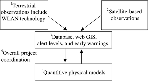
Figure 1. Diagram presents relationship among the five tasks in the Exupéry VFRS.
Note: The first task provides classic seismic and novel (high-resolution local deformation measurements and terrestrial gas measurements) observation systems to the VFRS. In order to provide the data collected in the field in real time to the database a reliable wireless communication including sufficient bandwidth is necessary. The second task includes space-based observations into the VFRS; in the recent years developments in space-based observations have opened up a new field in volcanology allowing the mapping of deformation, identification of broad degassing signatures, and the detection of thermal anomalies. The third task is a central for the whole system. It allows storing, browsing, accessing, and visualizing multi-component datasets (raw and/or parameterized) recorded at active volcanoes during a crisis. The fourth task works on changes in a volcano stress distribution. None of the methods available at hand provides a direct assessment of the stress or even better changes in the stress distribution. It is therefore necessary to further process the incoming data, if possible in real time, to better characterize stress changes. The fifth task is in charge of the overall project coordination and prototype installation (Azores, April–September 2009).
The whole system has just (April–September 2009) been tested on the Azores. This test includes the wireless communication network, 20 seismic stations, ground-based measurements of deformation, and gas flux. In addition, we will also use the data that are currently recorded by the existing seismic network on the Azores. The land network will be complemented by ocean bottom seismometers and tiltmeters, whose data will be added to the database after the seagoing experiment. We will use all the data collected during the test experiment to further improve the algorithms developed to assess the activity state of the volcano.
3. Data acquisition and storage
The decision support system can properly function only when requested data are available as soon as possible, most likely in real time. These data can be extremely heterogeneous (e.g. in our case GPS measurements provide an estimate of the position with a high accuracy every second vs. GOME-2 that provides SO2 data once per day for a pixel sized 80 by 40 km) and in order to provide these data to a user in (near) real time an appropriate network among the sensors and the data center has to be used. In recent years, the focus in the networking field was pointed to geosensor network tehnology. A geosensor network, often referred to as a sensor web, is a system of intra-communicating spatially distributed sensor pods that can be deployed to monitor and explore new environments (Delin and Jackson Citation2001). A geosensor network consists of usually low-cost, low-power semi-autonomous sensors with on-board wireless communication capabilities (a good overview is found in Liang et al. Citation2005). In this set of instruments, information from one or more sensors can automatically be used to reconfigure the remainder of the sensors.
An excellent example of geosensor network is Volcano Sensorweb project that is currently being developed by Jet Propulsion Laboratory (Davies et al. Citation2006, Chien et al. Citation2007, JPL Citation2009). This project tries to combine field units (containing a seismometer to detect earthquakes, a GPS receiver to point the location and measure subtle ground deformation, an infrared sounder to sense volcanic explosions, and a lightning detector to search for ash cloud formation) with satellite instruments. The field units are packed in a box (size of a microwave oven) that sits on top of a three-legged tripod. The instruments are powered by batteries that can last for a year. Field instruments can not only communicate among each other but also with EO-1 satellite that carries also a hyperspectral sensor Hyperion. In the case, the field instruments sense an increased volcano activity, they order Hyperion to map the thermal anomalies in over 200 channels with a spatial resolution of 10 m. The acquired satellite image then makes it possible to automatically reassess the current state of the volcano and the importance of each field instrument.
Comparing the definition of the geosensor network to our system, we can find an important difference – information from one or more sensors is in our case not automatically used to reconfigure the remainder of the sensors. One of the reasons for that is that we do not have control over some instruments; e.g. the satellite instruments in our project are controlled by NASA and ESA, thus satellite data are merely processed from some standard data products (e.g. level 1b images) at the data center (not at the volcano observatory) and then imported into the database. In addition, data from marine instruments cannot be used not even in the near real time because of lack of appropriate wireless communication between the instruments on the ocean bottom and the central station. Nevertheless, as in the geosensor network the backbone of our mobile system is its wireless communication. Most data are then accessed via the seedlink protocol, which forms a unified data portal for a wide variety of commercial digitizers (Hanka et al. Citation2000). The well-defined plug-in concept of seedlink makes it also possible to easily include up to then unknown data sources. All incoming data are then stored in a newly developed, central database – SeisHub.
The SeisHub (Barsch Citation2009) database is a web service using the Representational State Transfer (REST) architectural style (Fielding Citation2000) for interfacing with client applications and a SQL back-end for data storage. This allows the usage of both worlds: the power of the SQL language for querying and manipulating data and any standard connected to XML resources, e.g. document conversion via Extensible Stylesheet Language Transformations (XSLT) or resource validation via XSD (XML Schema). The actual resources and any additional services (mappers) are available via fixed URIs. The SQL back-end keeps the original XML document and all related indexed values. Indexes are generated using the XPath language and may be added at any time during runtime. This flexibility of the proposed XML/SQL mixture allows that parameter or results (i.e. 2D-InSAR pictures, models, etc.) as well as metadata from additional or yet unknown monitoring techniques other than the ‘classical’ ground-based methods can be included at any time. Further, main features of SeisHub are various access protocols (HTTP/HTTPS, SFTP, and SSH), an extensible plug-in system, user management, and a web-based administration front-end. The SeisHub database is an open source project and the latest development release can be downloaded via www.seishub.org.
In addition, two independent automatic analysis systems are fed by the online wireless communication in parallel. One is the well-established EARTHWORM system (Johnson et al. 1995), the other is the newly developed SeisComP3 package (Weber et al. Citation2007). While the first system is installed at various seismological and volcanological observatories around the world, thus making a connection between the local surveillance network and the VFRS installation more feasible, the latter follows a more up to date software concept and may point to future developments. Whatever automatic analysis package is finally used, both of them have to be adapted to the needs of volcanology. In this case, several strictly volcano related software modules are already written for EARTHWORM (Johnson et al. Citation1995) by the community as well as the VFRS group. The results (e.g. types of volcano-seismic events, estimated hypocenters, Realtime Seismic Amplitude, or Seismic Spectral Amplitude) are exported in XML and are then included into the database for further (interactive) use.
4. Decision support system
The following requirements have to be fulfilled when using the decision support system in VFRS in order to significantly improve the decision-making process. The system should be:
-
able to get instant access to the results of the field measurements;
-
able to inform decision makers;
-
easy to use also for non-professionals enabling an easy results interpretation;
-
easy to set up for new users and projects;
-
operational on various operating systems with none or minimal installation efforts;
-
open source/license free in order to ensure conforming to the law use and installation of the local scientists;
-
possible to simultaneously display information from multiple sources; and
-
able to filter data before displaying them.
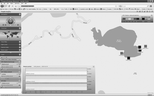
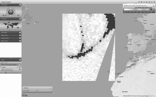
Figure 2. A sample scene of the web GIS interface showing the activity observed by the GPS network (no activity can be seen in the time plot).
Note: Controls for navigation, time filter, and seismic data are located together with the active layers list on the left side of the interface. Controls for project managing are located on the right side of the upper bar.
The decision support system is based on two key features: (1) an automatic alert level estimation; and (2) a GIS visualizing and combining all results achieved throughout the analysis.
4.1. Automatic alert level
The automatic alert level system is based on all parameter data (i.e. the results obtained by the analysis of different monitoring techniques) stored in the SeisHub database. The core component of the automatic alert level estimation is based on a Bayesian Belief Network (BBN), which evaluates the most likely state of an active volcano including the uncertainties of the parameter and the involved models. BBNs are chosen because of their fully probabilistic architecture and their transparent way in estimating the alert level. This is achieved by representing the (conditional) probability distributions as graphical models. As a first step a generic BBN is implemented, which is mainly based on expert knowledge collected at various volcanoes of the world. In a second step, the BBN is adapted to the local situation and monitoring network. The output consists of a sheer number (alert level) reflecting the activity state of the volcano, the confidence measure of the given alert level and the complete BBN (with all uncertainties and likelihoods), which led to the alert level. Especially, the confidence measure provides important information on how well the method performs, e.g. a high alert level with low confidence provides the extra information that the automatic procedure is not sure in its decision. Another advantage of the proposed method results from the possibility to interactively change the weights (probabilities), which led to a specific alert level. The BBN is re-evaluated once a day and the resulting alert level (1–3) and the associated BBN network (including the probabilities) is stored in the SeisHub database as well as transferred to the web GIS. A more detailed alert level would certainly be desirable, but the amount of available data and the export knowledge for training the complete network is little/vague. Therefore, a finer scale would lead to instable or wrong results.
4.2. Web GIS interface based on GeoServer
The web GIS interface is a three-tier application, consisting of a Flash application, backed by J2EE Application Server with servlets and the SeisHub database. The Flash application has a tiling algorithm and only requests the images needed for the current viewport. It also connects them with the Google Maps™ data. The generation of the images, the styling, and the requests against the SeisHub database are done by servlets. The front-end is really thin and has modest resource requirements.
The main component of the servlets is a mature open source, web-based GIS server called GeoServer (Garnett and Pumphrey Citation2009). GeoServer implements all the standards defined by the Open Geospatial Consortium (OGC Citation2009a). The techniques used for the Exupéry VFRS are Web Map Service (WMS; OGC Citation2009d), Web Feature Service (WFS; OGC Citation2009c), and Styled Layer Descriptior (SLD; OGC Citation2009b).
At some points the core GeoServer did not meet our requirements. The first problem was using time series of GeoTIFF images as GeoServer cannot handle it as one single data source. The usual solution would have been to generate one data source per GeoTIFF, but in this case the GeoServer must be restarted every time a new image is registered. Therefore, we patched the GeoServer and implemented a completely new data source entity for time series images.
The second problem was related to the coloring of seismic and GPS station layers. The color of the station should depend on the age of the last resource uploaded for that station. To reach this, dynamic styling had to be integrated into the GeoServer. Therefore, we patched again the GeoServer and included a simple scripting language into the SLD interpreter.
The third major problem was related to the bounding boxes (bbox) as the GeoServer works with fixed bboxes. To make the application more useful for users, we integrated a bbox requester, which returns the current bbox, containing all elements shown with a filter and a style applied.
4.2.1. Project and user environment of the web GIS interface
The system is designed to handle multiple projects. We define a ‘project’ as a timely and locally restricted operation of the Exupéry response team. The website containing the interface has information about the projects, which can be accessed. Therefore, it is possible to define websites for one or for multiple projects. The user management is connected to the user management implemented in SeisHub. Access is granted or denied simply by requesting the authentication module of SeisHub.
It is possible to save the interface state in the SeisHub database. It can be stored as private state that can only be loadable for the same user again, or as public state, where all users will be able to load that state. It is possible that one user selects a set of layers and saves them, which are then reviewed by some other users. Furthermore, the last interface state is always saved using a browser cookie.
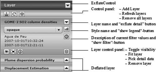
4.2.2. Layers and filters
The web GIS interface contains a layer model. Technically, a layer is a transparent image, which corresponds with a data source entity. Each layer has a list of describing information, a filter strategy, a list of applicable styles, and a format in which detailed information can be retrieved about displayed data. The layers are selected from a project specific layer tree (). Every layer has attached basic metadata, containing descriptions of the content, name of the responsible institute, and email of the contact person. Once a layer is selected, a new layer control is added to the layer list. It is possible to change the order of the layers in that list by simply dragging it onto the right position. It is also possible to select a style from a list of layer specific preconfigured styles, to show the accompanied legend, to change the filter, to fit the layer on screen, and to use the ‘info tool’ to request detailed data for each point of the layer.
Figure 3. Layer list with three sample layers; one can add or remove layer(s), set the layer visualization style, show layer legend, change layer time span, toggle layer visibility, fit layer to the screen, and pick detail data by a mouse click on a layer.
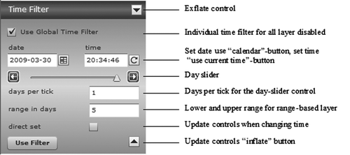
Using the ‘show filter’ button, the current filter of the layer is changed. Depending on the data source, different criteria of the data can be used for filtering. Commonly, the filter contains a time-slider control, which is used for either selecting a certain time or a time span. This time-slider control is disabled, when the global time filter is enabled (). In this case, the time is selected automatically. It is possible to select the time span from project start until project end or from project start until current time, if the project has not ended yet. The valid time span depends on the selected duration. For discrete time-based layers, the dataset closest to the selected time is chosen. If there is no valid dataset, the layer is out of sync and its control is greyed. For continuous time-based layers the duration is chosen.
Figure 4. Global time filter control; one can set up the global time filter by selecting the start and end date, and the number of days per tick.
4.2.3. Alert level control
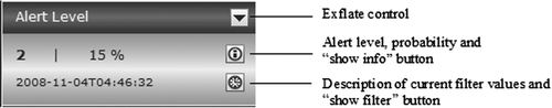
The automatic alert level is situated on a separate control (), appropriately to its importance. It shows the alarm level from one to three and its probability, according to the selected filter. Additional information pops up when clicking the ‘show info’ button. If the global time filter is activated, the time is selected automatically.
Figure 5. Alert level control also shows its probability. In the next months, we will make it possible to interactively reassess the alert level.
5. Conclusion
Volcanologists are able to estimate an alert level if they have appropriate data available. These data, however, are usually of little meaning to local authorities because they are too complex. Exupéry VFRS thus provides two levels of information. Scientists can use appropriate queries to access even the raw data from the VFRS database. Local authorities and decision makers, however, have access merely to the most relevant information presented over the VFRS decision support system. The system also allows experts from abroad to participate during the decision-making process as they have access to the relevant data through the web GIS interface. Using all information provided the automatic alert level and the web GIS visualization, the decision makers can then finally set the official alert level.
The VFRS decision support system was developed as a Flash application in order to easily access the web GIS interface. To ease the navigation and to display the data in a familiar context, we integrated Google Maps™ control. Thus, all the data are immediately in geographical context and could be easily read by non-professionals, concerning size and location. In addition, by overlaying existing GIS datasets (e.g. land use, vulnerable objects, critical industrial complexes, etc.), existing evacuation plans as well as evacuation routes can be reconsidered or possibly optimized. The web GIS interface is based on open source software GeoServer. Because it has some limitations, we enhanced it by compiling new functionality (time series imaging and data store processing) into it. All enhancements will be released as open source add-ons for the GeoServer community.
As the field experiment is currently still in progress, the VFRS decision support system is also still under development and therefore the actual prototype can differ from the description given in the article. The data from the prototype installation are online located at the link www.exupery-gis.org. The data show that there has been no major activity on Azores in the last months (e.g. we detected merely some minor ground motions using ground-based Synthetic Aperture Radar system). However, we experienced already one false alarm that was caused by the high concentration of SO2 detected by the GOME-2 satellite instrument. There was an eruption of Sarychev Peak on 12 June 2009. This volcano is situated in Kuril Islands, Russia and its eruption lasted several days. It released a huge SO2 cloud into the atmosphere that was dispersed by the wind over the Pacific Ocean, North America and Atlantic Ocean reaching Europe on 26 June 2009 () – the SO2 had nothing to do with the activities on the Azores. This is the reason we decided to give the user an option to interact with the alert level estimation. Technically will be the interaction solved by opening a new tab in a web browser after a click on the alert level control. A user will be able to change the weights of the measurements direct in the graphical representation of BBN and make a new estimate of the alert level. The software solution for the interaction is still under development but once it is finished it will additionally enhance the reliability of the presented decision support system.
Figure 6. False alarm; GOME-2 satellite image shows a high concentration (dark) of SO2 over the Atlantic Ocean on 26 June 2008.
Note: The SO2 source were not Azores, it was Sarychev Peak (Kuril Islands, Russia) whose eruption started on 12 June 2009. The SO2 cloud reached Europe after crossing the Pacific Ocean and North America. The gap in the layer area is the consequence of satellite coverage – the image consists of two tracks and the gap was not covered by the GOME-2 on that day.
Notes on contributors
Stefan Bernsdorf is currently working as a freelance programmer and IT expert (www.centauron.de) in the field of Geosoftware. He has 10 years of experience in GIS development, as he was a senior developer of a governmental GIS before.
Robert Barsch is currently finishing his PhD thesis ‘Web-based technology for storage, processing, and simulation of multi-component data in seismology – first steps towards a new design’ at the Department of Earth and Environmental Sciences, Ludwig-Maximilians-University, Munich, Germany. His main research interests focus on coupling classical geophysical problems, especially in the field of seismology, with web- or IT-based solutions.
Moritz Beyreuther is currently working on his PhD thesis at the Department of Earth and Environmental Science, Ludwig-Maximilians-University, Munich, Germany. His research interests are artificial intelligence methods with focus on their application to observational seismology and to automatic processed data at volcanoes.
Klemen Zakšek received his PhD in remote sensing from the University of Ljubljana, Slovenia, in 2007. Currently, he is employed by the Institute of Geophysics, University of Hamburg, Germany; he works on satellite thermal anomaly monitoring of active volcanoes and lectures GIS. His research field includes thermal remote sensing, parameterizations of solar radiation and air temperature, and applications of digital elevation model.
Matthias Hort received MSc and PhD degrees in geophysics from the University of Münster, Germany, in 1987 and 1991, respectively. After his PhD, he was with the Department of Earth and Planetary Science, Johns Hopkins University, Baltimore, MD, USA, for more than 2 years. He returned to Germany in 1994 to work with the GEOMAR Research Center, Kiel, Germany, in the Volcanology Department as an Assistant Professor. Since May 2003, he has been a Full Professor for marine geophysics and geophysical volcanology with the Institute of Geophysics, University of Hamburg, Hamburg, Germany. His current research focus is on the generation, rise, eruption, and dispersion of volcanic material, including melting processes in the mantel, eruption dynamics, and atmospheric processes, as well as instrument development for geophysical volcanology.
Joachim Wassermann received his PhD in geophysics from the University of Stuttgart, Germany, in 1997. After his PhD he was with the Institute of Geophysics of the LMU Munich for half a year before he took a 6-year assistant professorship at the Institute of Geosciences, University of Potsdam. Since 2004, he is senior research scientist at the Geophysical Observatory of the LMU Munich. His research interests are observational seismology with main focus on signal processing and the automatic ‘real-time’ processing of seismological network/array data at volcanoes.
Acknowledgements
The Exupéry project is funded by the German Ministry for Education and Research (BMBF) through project Geotechnologien.
References
- Barsch R. 2009 SeisHub [online]. Available from: http://www.seishub.org/ [Accessed 21 July 2009]
- Chien S. et al. 2007 Lights out autonomous operation of an earth observing sensorweb [online] Proceeding of the 7th international of RCSGSO symposium, 11–15 June 2007, Moscow, Russia Available from: http://ai.jpl.nasa.gov/public/papers/chien_rcsgso2007_sensorweb.pdf [Accessed 10 August 2009]
- Davies , A.G. 2006 . Sensor web enables rapid response to volcanic activity . EOS , 87 ( 1 ) : 1 – 5 .
- Delin , K.A. and Jackson , S.P. 2001 . The sensor web: a new instrument concept . Proceedings of the SPIE International of Optical Engineering , 4284 : 1 – 9 .
- Fielding R.T. 2000 Architectural styles and the design of network-based software architectures PhD thesis. University of California
- Garnett J. Pumphrey M. 2009 Geoserver [online]. Available from: http://geoserver.org/ [Accessed 21 July 2009]
- Hanka W. Heinloo A. Jaeckel K-H. 2000 Networked seismographs: GEOFON real time data distribution [online] ORFEUS Newsletter Available from: http://www.orfeus-eu.org/Organization/Newsletter/vol2no3/geofon.html [Accessed 21 July 2009]
- Johnson , C.E. 1995 . Earthworm: a flexible approach to seismic network processing . IRIS Newsletter , 14 ( 2 ) : 1 – 4 .
- JPL 2009 Volcano Sensorweb [online] Available from: http://ai.jpl.nasa.gov/public/projects/sensorweb/?msource=11709&tr=y&auid=5163523 [Accessed 10 August 2009]
- Liang , S.H. , Croitoru , A. and Tao , C.V. 2005 . A distributed geospatial infrastructure for sensor web . Computers & Geosciences , 31 ( 2 ) : 221 – 231 .
- OGC 2009a Open Geospatial Consortium [online]. Available from: http://www.opengeospatial.org/ [Accessed 21 July 2009]
- OGC 2009b Styled Layer Descriptor [online]. Available from: http://www.opengeospatial.org/standards/sld/ [Accessed 21 July 2009]
- OGC 2009c Web Feature Service [online]. Available from: http://www.opengeospatial.org/standards/wfs/ [Accessed 21 July 2009]
- OGC 2009d Web Map Service [online]. Available from: http://www.opengeospatial.org/standards/wms/ [Accessed 21 July 2009]
- Schmincke , H-U. 2004 . Volcanism , Heidelberg : Springer Verlag .
- USGS 2008 U.S. Volcano Disaster Assistance Program [online] USGS. Available from: http://volcanoes.usgs.gov/vhp/vdap.php [Accessed 21 July 2009]
- Weber B. et al. 2007 SeisComP3-automatic and interactive real time data processing [online] Geophysical Research Abstracts 9 Available from: http://www.cosis.net/abstracts/EGU2007/09219/EGU2007J-09219.pdf [Accessed 21 July 2009].