Abstract
Spatial Observation Services and Infrastructure is a project to develop and verify innovative infrastructure and services within the context of land monitoring and Earth Observation initiatives at European and Member State (MS) levels. The project's results contribute to the concept definition of the Shared Environmental Information System (SEIS) emphasising symmetrical online sharing of information as opposed to unidirectional reporting. In a pre-operational set-up, involving the European Environment Agency (EEA), four MS sites and the European Space Agency (ESA), a decentralised information system respecting the Infrastructure for Spatial Information in Europe (INSPIRE) principles is demonstrated integrating distributed data and processing services as well as interactive multi-lingual access.
The geoland2 project is carried out in the context of Global Monitoring for the Environment and Security (GMES), a joint initiative of the European Commission and ESA, aiming to build up a European capacity for GMES. The Spatial Data Infrastructure (SDI) task shall set up operational services for the discovery, viewing, access and delivery of all products generated in the geoland2 project.
The paper presents the projects along the five International Standards Organisation (ISO)/Reference Model of Open Distributed Processing viewpoints and concludes with the main recommendation that service provisioning can strongly benefit from a (re-) utilisation of the Service Support Environment (SSE) technology provided sustainably by ESA and from the related rich experience.
Background and context
Shared Environmental Information System (SEIS) – a European perspective
According to the European Union's 6th Environmental Action Programme aiming at a Sustainable Development Strategy integrated assessments of environmental information are becoming the trend. This nurtures the vision of a Shared Environmental Information System (SEIS) whose scope is to improve, modernise, streamline and connect Environmental Information Systems in Europe and world-wide (EC Citation2008a). From the European Environment Agency's (EEA's) perspective (Steenmans Citation2009) SEIS is about:
-
Sharing (organisation): political commitment (legislation); partnership (win-win); networking (connecting).
-
Environmental information (content): horizontal integration (data centres); vertical integration (local to global); online access-real time for policy-makers and public.
-
System (infrastructure and services): existing ICT infrastructure; INSPIRE, Reportnet, Global Monitoring for the Environment and Security (GMES), etc.; New e-Services (e-Government).
Global Monitoring for the Environment and Security (GMES) – land services
GMES ‘Global Monitoring for the Environment and Security’ is the European initiative for the establishment of a European capacity for Earth Observation (EO). In this context Land Information Services operationally provide sound, reliable and affordable land related geo-information products on a regional, European and global scale.
The Land Information Services are based on the combination, analysis and modelling of data received from EO satellites as well as ground based sensor networks. Thereby these services provide wide-area and cross boarder harmonised geo-information products for a multitude of thematic areas, like land use/land cover (LC/LU) change, soil sealing, water quality and availability, spatial planning, forest management, carbon storage and global food security.
Spatial Observation Services and Infrastructure (SOSI) – verification of infrastructure and services concepts
SOSI stands for an ESA-funded demonstrational set-up of ground and user segment technology and operations schemes of ‘Spatial Observation Services and Infrastructure’ within the context of LC monitoring and EO initiatives at European and Member State (MS) levels. The project is motivated by the need for verification of today's SEIS infrastructure and services concepts (see Section ‘SEIS – an European Perspective’ above). The project's objective is to demonstrate distributed data and processing services as well as decentralised access at multiple levels, languages and content granularities. A number of processing and archiving facilities for EO and LC/LU products hosted by institutions in Austria (AT), Czech Republic (CZ), Hungary (HU), Luxemboug (LU) and by the EEA in Denmark (DK) are linked within the European Space Agency's (ESA's) Service Support Environment (SSE) standards-based (e.g. INSPIRE, Open Geospatial Consortium (OGC), Heterogenous Missions Accessibility (HMA)) service architecture.
SOSI is a:
-
Project (time/resources limited) contracted by ESA.
-
Service-Oriented Architecture (SOA) concept.
-
Demonstrator system (operated over a limited time period).
-
Concept verification activity performed jointly with EEA, MS and ESA.
geoland2 Spatial Data Infrastructure (g2/SDI)
Currently the first GMES services are in place in pre-operational mode. At that stage, the provision of these first services is ensured through R&D projects funded under the 7th Framework Programme (FP7) of the European Union. The GMES Land Monitoring Core Service (LMCS) is developed in the project called geoland2.
Among the results of this service are the Spatial Data Infrastructure (SDI) which serves as central platform for data and metadata distribution. The information handled by this platform includes the product portfolio generated from geoland2 as well as the input needed for its generation. Obviously the uptake of international geospatial standards is crucial to the success and acceptance of the SDI.
Coherence with INSPIRE, Global Earth Observation System of Systems (GEOSS) and wider Global Monitoring for the Environment and Security (GMES) architectures
A key goal of the projects under consideration is to ensure coherence with architectures dealt with by the programmes, projects and standards initiatives given in .
Table 1. Sources of standards requirements for g2/SDI and SOSI.
In spite of the complexity and dynamics of the listed programmes and projects the geoland2/SDI and SOSI projects can build upon the latest status and specifications through formal involvement of project team members within OGC, HMA/Data Access Integration Layer (DAIL) and GEOSS, INSPIRE, and GMES on Action in Support (GIGAS).
Service Support Environment (SSE)
SOSI utilises the SSE (Coene and Bawin Citation2004, ESA Citation2009) which is a freely available overarching infrastructure permanently and in a sustained manner hosted and operated by ESA that facilitates the set up of operational services for EO. Currently more than 290 services are connected to SSE serving over 1700 registered professional and science users. SSE is beneficial for Service Providers (SPs):
-
Allowing SPs to fully control their own infrastructure.
-
Reducing service set-up/demo costs and time to market.
-
Allowing an easy re-use of generic or basic services.
-
Allowing SPs to concentrate on their own specific skills and added value.
-
Combining and chaining service elements within the supply chain.
-
Enabling the cooperation between SPs, etc.
Relationship Global Monitoring for the Environment and Security (GMES), INSPIRE, Service Support Environment (SSE), geoland2 and Spatial Observation Services and Infrastructure (SOSI)
SOSI does not aim to be a general architecture for Land Monitoring Network Services but it is a demonstration of the suitability of the SSE architecture for these services.
In coordination with the SOSI activity the GMES SDI for Land Monitoring has been developed in the framework of the geoland2 project, also utilising SSE architecture principles and implementations. As a consequence the services connected within the SOSI network are readily available in the GMES service environment since they have been implemented in the very similar SSE principle.
For the SOSI service design INSPIRE implementing rules and technical guidelines are considered to the level they are available or specified in detail such as decentralised geo-data management, service typology (discovery, view and download), technology platforms (OGC Web Service (OWS), bindings) and geo-content standards (in particular metadata).
Spatial Observation Services and Infrastructure (SOSI) Demonstration System
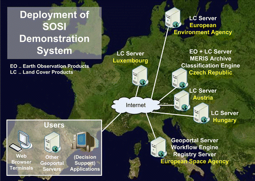
The SOSI Demonstration System under implementation is shown in . Four servers hosting MS-level services are installed in Austria, Czech Republic, Hungary and Luxembourg. An European-level service is provided by the EEA. The SSE hosted at ESA provides the geoportal, workflow and registry functionality. The services and their characteristics are further explained in chapter ‘Service viewpoint’. They are ‘consumed’ by various users on the Internet utilising different kinds of clients.
Figure 1. SOSI servers in Member States and at European Agencies.
geoland2/Spatial Data Infrastructure (g2/SDI) – implementation
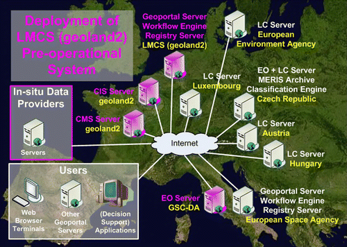
shows the geoland2/SDI Implementation (added parts) as well as the SOSI Demonstration System. The strong commitment to international geospatial standards allows the reuse of services and other system components.
Figure 2. Integration of SOSI Demonstration System into g2/SDI implementation.
Architecture viewpoints
The Reference Model of Open Distributed Processing (RM-ODP) (ISO/IEC Citation1996a, Citation1996b, Citation1998a, Citation1998b) is an architecting standard which is widely adopted as best practice approach by the geospatial data system engineers e.g. by the GIGAS project (Biancalana et al. Citation2009). Presentations of the five RM-ODP design viewpoints, tailored to SOSI and g2/SDI, are the subjects of the following chapters and subchapters.
Spatial Observation Services and Infrastructure (SOSI) architecture
Enterprise viewpoint
From reporting to sharing
The SOSI design concept is driven by SEIS principles (Steenmans Citation2009) that data and information shall be:
-
Managed as close as possible to its source.
-
Collected once and shared with others for many purposes.
-
Readily available to public authorities to easily fulfil reporting obligations.
-
Accessible to enable end-users to make comparisons at appropriate geographic scale.
-
Available to the general public after due consideration of the appropriate level of aggregation, given possible confidentiality constraints and at national level in the national language(s).
Eionet and evolution of Reportnet
SOSI receives design guidelines and standards (e.g. the general multilingualenvironmental thesaurus (GEMET)) established by EEA and within Eionet which is a partnership network of EEA and its member and cooperating countries involving approximately 900 experts and more than 300 national institutions. The network supports the collection and organisation of data and the development and dissemination of information concerning Europe's environment.
The SOSI implementation is targeted to be linked with Reportnet which is Eionet's infrastructure for supporting and improving data and information flows. Reportnet is based on a set of inter-related tools and processes which all build on the active use of the World Wide Web. SOSI is specifically associated with the objectives and functionalities of the EEA LU site which offers live maps and EEA data centre services under the address http://www.eea.europa.eu/themes/landuse. It is required, for example, that SOSI network services can be accessed via the existing EEA LU site.
Global Monitoring for the Environment and Security (GMES) Fast Track Service on Land Monitoring
Essential innovative functionality is provided by SOSI for orchestration of network services within workflows. Product generation chains which, in the past, transferred data between processing nodes on offline physical media shall be demonstrated in SOSI to be handled, in the future, via online management and data dissemination procedures. The GMES Fast Track Service on Land Monitoring which was implemented by EEA, EC and ESA is considered as a template for a SOSI demonstration example. It delivered the following products:
-
Ortho-rectified satellite images for the reference year 2006 (± − 1 year).
-
European mosaic based on ortho-rectified satellite imagery (IMAGE2006).
-
Corine LC changes 2000–2006.
-
Corine LC map 2006 (CLC2006).
-
High resolution core LC data for built-up areas, including degree of soil sealing, 2006.
-
High resolution core LC data for forest areas 2006.
The related requirements established for the SOSI Demonstration System are to:
-
Mimic the current geoportal access to CLC2000, CLC2006 and built-up area products keeping the products close to their geographically distributed generation services, i.e. not, as currently done in a centralised product repository.
-
Demonstrate a processing chain fully managed as an online workflow spanning these distributed product generation services.
Specific requirements in Member States (MSs)
The requirement for the SOSI processing workflow demonstration described in the previous section is instantiated as a semi-automated LC product generation chain sourced by an Envisat MEdium Resolution Imaging Spectrometer (MERIS) satellite EO product archive in the Czech Republic. As prerequisite for this demonstration implementation a user service facility is implemented at the MERIS archive supporting data discovery and downloading services. A case study focusing on benchmarking of MEEO Soil Mapper classification solution is another SOSI activity run in the Czech Republic.
Beside the Czech MERIS EO services a national Czech SOSI LC geoportal is to be implemented. Except for the European LC datasets described above it will also include selected national GMES LC datasets and samples of low resolution LC products based on MERIS imagery. A SOSI geoportal for LC data access is also set up in Hungary which has to support a Hungarian national language user interface.
Information viewpoint
Metadata models
Service and Collection Metadata are used in SOSI to provide the details for machine-to-machine communication (operations, coupling of operations) but also contain descriptive information targeted at human readers (identifying properties of the described data or services). These metadata are in XML format, their standard references are: ISO 19115, ISO 19119, and OASIS UDDI v2 Metadata.
EO Product Metadata are specified in XML format and based on Geography Markup Language (GML) Encoding Specification, OGC 03-105 and 02-069 (ISO 19136) and GML 3.1.1 Application Schema for EO Products, OGC 06-080.
Spatial data sets
Various delivery formats are expected by the community (e.g. GeoTIFF, JPEG2000, HDF). Conceptually (as in SSE and HMA), spatial data sets addressed in SOSI can be classified:
-
With respect to production mechanism as Stream (regularly disseminated with pre-defined frequency, with given time window and given area); cumulative (disseminated at package completion); Standalone (one-off dissemination after single request).
-
With respect to triggering as Pre-defined Data Sets (well-defined user needs/area defined in advance); or On-demand Data Sets (specification that cannot be identified in advance, e.g. emergency monitoring).
-
GMES Fast Track high resolution core LC data for built-up areas, including degree of soil sealing 2006; European-level seamless and MS-level products; updates are foreseen generated from 2009 source EO data acquisitions;
-
Corine LC-CLC2000 and CLC2006, and specific national LC products.
-
Envisat MERIS data and derived LC Products (currently under specification).
Service viewpoint
The informative documents ‘INSPIRE Technical Architecture Overview’ (INSPIRE Citation2007) and ‘INSPIRE Network Services Architecture V3.0’ (INSPIRE Citation2008) are key references for the SOSI service design. The SOSI architecture (conceptual and Demonstrator System) includes the services listed in the right column of . The left column holds the service class according to the Global Earth Observation System of Systems (GEOSS) taxonomy which is equivalent to the service taxonomy of ISO 19119 (ISO/TC 211 Citation2001). The SOSI Service Metamodel is shown in . Indications are given about which service is to be supported by SSE Technology – see chapter ‘Technology viewpoint’. Transactional functions for ingesting the metadata, spatial data sets and register data into the indicated data sources are considered to be parts of the inherent data base management functions, though a use of network services could be considered (e.g. based on OGC Web Feature Service Transactional (WFS-T) or Web Coverage Service Transactional (WCS-T) technology).
Figure 3. SOSI Service Metamodel.
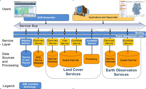
Table 2. SOSI services.
Engineering viewpoint
SOSI is designed as a loosely coupled system based on networked services enabling distribution through functional decomposition into objects which interact at standard interfaces. Conceptually, SOSI aims to be an open system into which additional services can be added, without the need for additional software development, assuming interfaces are precisely followed.
SOSI is designed for scalability to cope with growing user numbers. This means that it is possible, if needed, to add additional CPUs and balance the load on multiple machines, in a way that is transparent to the SOSI application software. In the SOSI Demonstration System set-up this is demonstrated for the SOSI geoportal hosted on the computer centre facilities at ESA distributing the load of all SSE induced traffic to a number of CPUs.
SOSI places no restriction on the granularity of a (Web) service that can be integrated. The grain size can range from small (e.g. a component that must be combined with others to create a complete business process), to large (for example an entire value chain).
Technology viewpoint
SOSI is based on SOA principles. The drivers of the architecture are open standard specifications from the bodies ISO, OASIS, W3C and OGC.
shows the software which is used in the SOSI Demonstration System. The discovery, view and downloading services are implemented entirely on Open Source tools implementing the shown Web server protocol standards. Open Source software is also used for back-end database management.
Figure 4. SOSI Software and Web Protocols.
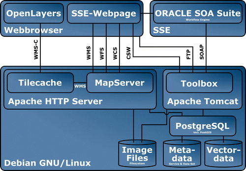
The SSE components which are deployed as platforms in the SOSI project are:
-
SSE Portal Server, provides the SOSI workflow engine (ORACLE SOA Suite 10.1.2) which orchestrates distributed services; several wizards for service registration at the SSE are available.
-
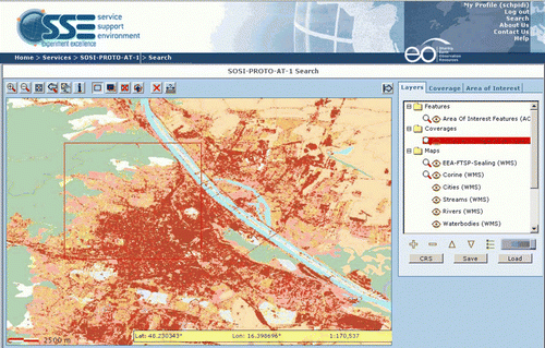
The SSE WebMapViewer forms the cartographic display of the SOSI geoportal. It provides the functionality to define Area(s) Of Interest (AOI) by end-users as input to services and for receiving portrayal and download service results (see ).
-
The SSE Toolbox provides a wrapper for legacy services at SOSI SPs to SOAP web services. It supports synchronous and asynchronous service calls and includes an FTP server. The runtime environment provides a rich stand-alone test centre for services. There is also a development environment providing an Eclipse plug-in for the whole service life-cycle (i.e. development, testing, debugging, configuration control, deployment, etc.).
Figure 5. SOSI Geoportal Supporting Product and service discovery, Versatile Area of Interest Definition, WMS-based viewing and WCS-based downloading.
geoland2 SDI architecture
Enterprise viewpoint
geoland2 intends to constitute a major step forward in the implementation of the GMES LMCS. The three components (Local, Continental and Global) of the LMCS are addressed. The architecture of geoland2 is made of two different layers, the Core Mapping Services (CMS) and the Core Information Services (CIS).
The SDI task within the geoland2 project aims at setting up an operational service for the discovery, viewing, access, delivery and the support of all products generated in the geoland2 project by the CMS and CIS. The CMS and CIS can be both data producer and/or data consumer.
The SDI is designed to fulfil the needs of the different data providers and data consumers in the project. In addition this is done with respect to the INSPIRE directive to ensure an easy integration of the SDI in the context of the European SDI.
Information viewpoint
The three CMSs produce ‘basic’ LC, LC change and land state products which are of broad generic use and can be directly used for deriving more elaborated products. The CMS products cover a wide variety of thematic content, spatial scales from local to global and update frequency, from one day to several years.
The seven CIS are a set of thematic elements that start from CMS products and other data sources to produce ‘elaborated’ information products addressing specific European policies.
Together they define the Product Portfolio of geoland2 and which is handled by the SDI. Further details about the Product Portfolio can be found in the communication of the European Commission (EC Citation2008b).
Service viewpoint
Like for SOSI, the INSPIRE principles are key references for the g2/SDI service design. The following services will either be provided by or consumed by the SDI:
-
Human interaction services
-
Discovery clients
-
On-line data access clients
-
User Registration client
-
Ordering client.
-
-
Discovery services
-
Collection and service discovery
-
Dataset catalogue
-
-
On-line data access services
-
View services: WMS
-
Download services: WFS, WCS, FTP Push/Pull, satellite multicast
-
Ordering service
-
-
User management services
-
Authentication service
-
Authorisation service
-
User Registration Service
-
Engineering and technology viewpoint
g2/SDI relies on the same software components as ESA's SSE used by SOSI. Thus, these viewpoints on the g2/SDI are already covered in chapters ‘Engineering viewpoint’ and ‘Technology viewpoint’.
For the services which are connected to the g2/SDI only the required interface specifications as introduced in the previous chapter are defined. Thus no further technology choices or engineering principles can be defined from the viewpoint of the g2/SDI team. On the other side there are recommendations resulting from the SOSI project which could be adopted by the geoland2 SPs.
Conclusions and recommendations
In the search for suitable approaches to modernise and simplify the collection, sharing and use of data and information required for the design and implementation of environmental policy in Europe, the SOSI project is contributing technical concepts for strategically important LC services and infrastructure components. A demonstration of the full SOSI LC service functionalities was given on 26 June 2009 at ESRIN, Frascati to ESA and EEA. The EO service and LC generation service chaining demonstrations will be ready for verification towards the end of 2009. The following conclusions and recommendations can be made based on the conceptual designs of SOSI and first operational and prototypical system implementations.
The SSE, which is based on substantial experience with numerous operational services and users, should be considered as a valid and capable technological platform by those who need to implement services in the SEIS framework quickly, cost-efficiently and based on the latest knowledge. A wide range of international architecture and technology standards is already pre-digested in the SSE tool suite helping SPs and their engineers to get up quickly on the learning curve. Service provisioning can strongly benefit from a (re)utilisation of the SSE technology provided sustainably by ESA and from the related rich experience.
From the SOSI perspective the following enhancements of SSE are required:
-
A federated user management and security layer, as proposed in the HMA initiative (OGC Citation2009), needs to be implemented in the SSE Portal Server (e.g. in the service registration wizards) as well as in the SSE Toolbox.
-
In order to achieve further INSPIRE conformity (INSPIRE Citation2008) the SSE WebMapViewer needs upgrading with respect to SOAP binding for OGC Web services (currently only Key-Value-Pair binding is supported).
-
General user feedback proves that a modernisation of the WebMapViewer map interface needs to incorporate latest technologies such as AJAX in order to stay comparable to other OWS clients.
-
Additionally required are enhancements of client functionality for optimum exploitation of INSPIRE Network Services like an automated bridging process from view to download.
Aligned with the SOSI approach, EEA and ESA should consider a ramping up of activities towards conducting an official OGC Pilot, inviting a larger community of MS representatives and user organisations into a collaborative effort that applies open standards for interoperability to achieve user objectives in a surrounding which is representative for operational use. With SOSI results at hand further consensus on architectures for geospatial information systems should be aimed at and carried forward into sustained operations.
The usage and implementation of services for ESA's SSE are seen as highly recommendable not only because of the technical advantages but also of the sustained hosting and operating, already contracted for the next half decade.
It should be easy to transfer results from the SOSI project to other projects and initiatives e.g. to geoland2 SPs.
Notes on contributors
DI Stephan Meissl is a Senior IT Consultant of EOX IT Services GmbH in Vienna, Austria, covering the CTO function. He is technical lead in the ESA funded Spatial Observation Services and Infrastructure (SOSI) project. He obtained Diplom-Ingenieur Technical Mathematics (Master of Science) with the thesis of Implementation of the KOMPSAT European Regional Archive Supporting the Open Geospatial Consortium (OGC) Web Map-, Web Feature-, and Web Coverage Service as well as International Catalog Interoperability from Vienna University of Technology. His research interests cover service standardisation and implementation in the area of Online Data Access especially to Earth Observation imagery, membership liaison with the OGC and involvement in the Open Source Geospatial Foundation (OSGeo).
DI Dr Gerhard Triebnig is Managing Director of EOX IT Services GmbH in Vienna, Austria. He obtained Doktor der technischen Wissenschaften (Dr techn.) with the thesis of An Interoperability protocol for Earth Observation User Information Services from the Institute of Information Systems and Computer Media of University of Technology Graz, Austria. His research interest is architecting of internationally interoperable Earth Observation satellite user services and GIS with applications in environmental monitoring.
Acknowledgements
The SOSI project is conducted under contract of the European Space Agency (ESRIN Contract No. 21776/08/IL-G and ESTEC PECS Arrangements with CZ and HU) and the strong in-kind steering support by the European Environment Agency (EEA). The authors especially wish to thank Mr. S. D'Elia and Mr. P.G. Marchetti from ESA for fostering and supporting this initiative, Mr. A. della Vecchia for the technical cooperation as well as Mr. C. Steenmans, Mrs. A. Sousa, Mr. J. Bliki, Mr. S. Jensen and the LUDC team from EEA for essentially having formed the project idea, and for accompanying its execution. The preparedness by the company Geoville to host the Luxembourg SOSI instantiation is very much appreciated. The contributions of the company Spacebel regarding SOA and SSE know how and of the company MEEO regarding automated LC generation are very valuable to the SOSI project. Special thanks for constructive and promising discussions as well as excellent work go to all project partners namely Siemens Austria, Siemens Hungary, ANF Data and Gisat.
geoland2 has received funding from the European Community's 7th Framework Programme under grant agreement FP7 218795. The authors express their special thanks to the SDI subtask partners Infoterra GmbH, VITO, Spacebel and UAB.
References
- Biancalana , A. , et al. , 2009 . Methodology for technology watch and comparative analysis of information and data management systems [online]. The GIGAS Consortium. Available from: http://www.thegigasforum.eu/cgi-bin/download.pl?f=333.pdf[Accessed 5 January 2010]
- Coene , Y. Bawin , C. , 2004 . Service support environment architecture, model and standards [online]. White Paper, European Space Agency (ESA). Available from: http://earth.esa.int/rtd/Documents/SSE_Whitepaper_2.pdf[Accessed 5 January 2010] .
- EC , 2008a . Towards a shared environmental information system (SEIS) [online]. EC. Available from: http://eur-lex.europa.eu/LexUriServ/LexUriServ.do?uri=COM:2008:0046:FIN:EN:PDF[Accessed 21 July 2009] .
- EC , 2008b . geoland2 – implementation of the land core service, GMES core-services under the seventh framework programme [online]. EC. Available from: http://ec.europa.eu/enterprise/policies/space/files/research/geoland2_core_products_and_services_update_081103_en.pdf[Accessed 21 July 2009] .
- ESA , 2009 . Service support environment [online]. ESA. Available from: http://services.eoportal.org[Accessed 21 July 2009] .
- INSPIRE , 2007 . INSPIRE technical architecture – overview V1.2 [online]. Drafting Teams “Data Specifications”, “Network Services”, “Metadata”. Available from: http://inspire.jrc.ec.europa.eu/reports/ImplementingRules/network/INSPIRETechnicalArchitectureOverview_v1.2.pdf[Accessed 21 July 2009] .
- INSPIRE , 2008 . INSPIRE network services architecture, V3.0 [online]. Network Services Drafting Team. Available from: http://inspire.jrc.ec.europa.eu/reports.cfm[Accessed 21 July 2009] .
- ISO/IEC , 1996a . ISO/IEC 10746-2:1996(E). Information technology - open distributed processing - reference model: foundations [online]. International Organization for Standardization (ISO) and International Electrotechnical Commision (IEC). Available from: http://standards.iso.org/ittf/PubliclyAvailableStandards/s018836_ISO_IEC_10746-2_1996(E).zip[Accessed 5 January 2010] .
- ISO/IEC , 1996b . ISO/IEC 10746-3:1996(E). Information technology - open distributed processing - reference model: architecture [online]. ISO and IEC. Available from: http://standards.iso.org/ittf/PubliclyAvailableStandards/s020697_ISO_IEC_10746-3_1996(E).zip[Accessed 5 January 2010] .
- ISO/IEC , 1998a . ISO/IEC 10746-1:1998(E). Information technology - open distributed processing - reference model: overview [online]. ISO and IEC. Available from: http://standards.iso.org/ittf/PubliclyAvailableStandards/c020696_ISO_IEC_10746-1_1998(E).zip[Accessed 5 January 2010] .
- ISO/IEC , 1998b . ISO/IEC 10746-4:1998(E). Information technology - open distributed processing - reference model: architectural semantics [online]. ISO and IEC. Available from: http://standards.iso.org/ittf/PubliclyAvailableStandards/c020698_ISO_IEC_10746-4_1998(E).zip[Accessed 5 January 2010] .
- ISO/TC 211 , 2001 . ISO 19119. Geographic information – service, same as: OGC 02-112: The OpenGIS abstract specification topic 12: OpenGIS service architecture [online]. OGC. Available from: http://portal.opengeospatial.org/files/?artifact_id=1221[Accessed 5 January 2010] .
- Nguyen , T.H. , et al. , 2009 . geoland2 - SDI Interface Control Document for CIS and CMS, G2-SDI-RP-0001 [online]. geoland2 SDI Team project deliverable. Available from: http://www.gmes-geoland.info/ktdms/view.php?fDocumentId=3160[Accessed 5 January 2010] .
- OGC , 2009 . OGC 07-118r3 . User management interfaces for earth observation services [online]. OGC. Available from: http://wiki.services.eoportal.org/tiki-download_wiki_attachment.php?attId=521&download=y[Accessed 5 January 2010] .
- Steenmans , C. , 2009 . The future of environmental information . Presentation at workshop: “Towards shared environmental information in Europe: opportunities and challenges for integrated research”, Centre for Ecology & Hydrology, Wallingford, UK, 28–29 January 2009. Available from: http://www.ceh.ac.uk/SEIS/documents/EEASEISCEH.pdf[Accessed 21 July 2009] .