Abstract
The Earth and Space Sciences Informatics division of European Geosciences Union (EGU) and the Open Geospatial Consortium jointly organised a special event entitled: ‘Implementation of international geospatial standards for earth and space sciences event’ – at the EGU General Assembly meeting held in Vienna, April 2009. The event objectives included: (a) to discuss the integration of information systems from different geosciences disciplines; (b) to promote and discuss the present process to scale from specific and monolithic systems towards independent and modular enabling infrastructures – forming an earth system science (ESS) infrastructure; and (c) to show some of the latest advances in implementing open standards. This manuscript introduces the event motivations and describes the abstract and holistic framework, which can be used to situate the topics and the developments presented by the event speakers. This manuscript introduces important, and relatively new technologies to build a multi-disciplinary geosciences information system: the System of Systems approach and the Model Driven Approach. To achieve that, three important information infrastructure categories are recognised: (a) ESS information infrastructure; (b) geospatial information infrastructure; and (c) distributed information infrastructure. Digital Earth should support the discussed framework to accelerate information transfer from theoretical discussions to applications, in all fields related to global climate change, natural disaster prevention and response, new energy-source development, agricultural and food security, and urban planning and management.
Introduction
Earth and Space scientists are engaged in integrating knowledge stemming from different disciplines about the constituent parts of the complex Sun–Earth system with the objective of understanding its properties as a whole system. Earth system analysis is a challenge for scientists as much as it is for information technology experts (Foster and Kesselman Citation2006). The scope and complexity of the Earth system investigations demand the formation of distributed, multidisciplinary collaborative teams. The growing area of geosciences informatics is concerned with providing integrated access to a range of advanced information and processing resources for the environment (Baker et al. Citation2008).
Advanced digital earth infrastructures (e.g. environmental e-infrastructure and earth observation cyber-infrastructures) are needed to support the formation and operation of an Earth system science (ESS) community, based on multidisciplinary knowledge integration. Recent international forums, like the Earth and Space Sciences Informatics (ESSI) divisions of American Geophysical Union (AGU, http://essi.agu.org/) and European Geosciences Union (EGU, http://meetingorganizer.copernicus.org/EGU2010/sessionprogramme/ESSI), and the International Society for Digital Earth (ISDE, http://www.digitalearth-isde.org/) promote the conceiving of experimentation reports of these digital infrastructures from science point of view (Nativi et al. Citation2009, Nativi and Fox Citation2010) – to complement and integrate the technological perspective.
A young scientific field called System of Systems (SoS) underpins the development of multi-disciplinary cyber(e)-infrastructures building on existing systems and teams; important examples are: Global Earth Observation System of Systems (GEOSS, http://www.earthobservations.org/); European Earth Observation Programme (GMES, http://ec.europa.eu/gmes/) and Infrastructure for Spatial Information in the European Community (INSPIRE, http://inspire.jrc.ec.europa.eu/).
Considering the 2009 Beijing declaration on digital earth (ISDE Citation2009), SoS technology can support the Digital Earth community to accelerate information transfer from theory to applications, in all fields related to global climate change, natural disaster prevention and response, new energy-source development, agricultural and food security, and urban planning and management. In fact, SoS approach increases the capacity for information resource-sharing and the transformation of raw data to practical information and applications. Holistic interdisciplinary approaches and lack of common data models and semantics are important research challenges to be addressed in order to achieve a Digital Earth information space.
There is a need to provide the earth sciences community with guidance to contribute to the many ‘SoS’ international initiatives – including: GEOSS, INSPIRE, GMES and SISE. In fact, existing assets (i.e. observation systems, data processing and analysis systems, archive, stewardship and discovery systems, and exploitation and decision-support systems) are numerous, geographically dispersed and evolving on their own time scales. Thus, specific guidance to assist in the evolution and/or development of these assets are important to make them able to interoperate effectively within the many SoS frameworks.
SoS deals with holistic solutions to implement resources interoperability and metadata sharing among disparate (i.e. heterogeneous and distributed) and autonomous systems. To address some of these interoperability challenges, the earth science communities have been developing interoperability specifications by profiling international standards according to their specific domain needs. This has resulted in a somewhat fragmented multi-speed geosciences community in terms of digital interoperability. The need to compare the on-going activities for disciplinary interoperability specifications and promote discussion forums on multi-disciplinary interoperability is clear.
Recently, EGU–ESSI and the Open Geospatial Consortium (OGC) (http://www.opengeospatial.org/) organised a special event to present some valuable interoperability specification achievements; these realisations pertain to different earth science domains, which help policymakers in important society applications. The present IJDE issue covers this special event presentations. EGU–ESSI and OGC are planning to organise such events on a regular basis. This manuscript aims to introduce the SoS challenges and opportunities that constitute the event motivations; it describes the abstract and holistic framework in which the presentation achievements must be considered. This manuscript is followed by another introductory paper about the OGC standard contributions to geosciences interoperability (Percivall Citation2010).
This manuscript is structured as follows. The following section will discuss the SoS approach to support environmental policymaking and its challenges. Having in mind the described holistic framework, the Section ‘Information modelling approach’ introduces three different information infrastructures embraced by a geosciences SoS. The Section ‘The special session: “implementation of international geospatial standards for earth and space sciences event”’ presents the special session jointly organised by EGU–ESSI and OGC. Finally, ‘Conclusions and future opportunities’ presents the manuscript conclusions and introduces the other manuscripts.
The System of Systems (SoS) approach to support environmental policymaking
There are numerous definitions for SoS and System of Systems Engineering (SoSE); in general terms, SoS is a collection of task-oriented, autonomous and distributed systems that pool their resources together to obtain a new, more complex, ‘meta-system’ (Jamshidi Citation2005).
In spite of a large-scale integrated system, the SoS components can operate independently to produce products or services satisfying their customer objectives (Butterfield et al. Citation2008). The component systems may be connected by implementing one or more interoperability arrangements that do not require tight coupling or strong integrations. This allows a SoS to maintain its inherent operational character even as system components join or disengage from it. Since SoS is a construct of both legacy and new systems, an important feature is the attention to holistic aspects. For instance, GEOSS will be a ‘system of systems’ consisting of existing and future Earth observation systems, supplementing but not supplanting their own mandates and governance arrangements (Group on Earth Observations [GEO] Citation2005).
Policymaking requires for multi-disciplinarily. Hence, building a SoS approach to support environmental policymaking demands the contribution of different disciplinary communities. Therefore, design for SoS problems is often performed under some level of uncertainty in the requirements and the constituent systems, and it involves considerations in multiple levels and domains.
To share multi-disciplinary resources, it is possible to recognise some general challenges by analysing the geosciences community requirements for an holistic approach (Nativi and Domenico Citation2009):
-
to control complexity using flexible and loosely coupled solutions (e.g. mediation and brokering technologies);
-
to distinguish between inter-community and intra-community interoperability arrangements;
-
to distinguish between ‘core’ and ‘advanced’ interoperability levels;
-
to consider both ‘scalability & extensibility’ and ‘reliability & stability’ features that characterise interoperability arrangements; and
-
to consider the interoperability arrangements impact on the software environments, which characterise the existing capacity.
-
Adopt different application levels of interoperability in order to control complexity. Examples include: (a) core plus extensions for accommodating specific community requirements/needs; (b) internal (advanced service functionalities along with implicit semantics of content) versus external - simple service functionalities along with explicit semantics of content.
-
Follow an information modelling approach. Generally speaking, meaningful interoperability of complex systems on the implementation level – such as needed within a SoS approach – requires composability of the underlying conceptual models. The shift from technical interoperability towards conceptual composability is needed. That is achieved by recognising and specifying interoperability arrangements. They connect autonomous systems at different infrastructural levels, which must be as de-coupled as possible. In addition, specifications must be as neutral as possible.
-
Follow an incremental approach for the specification of implementations; this is important to enable the development from existing capacity towards the new distributed computing (DC) platforms/environments; examples include: the specification and implementation of mediation solutions as well as middleware services for achieving transparencies.
-
Adopt a service specification approach more focused on user requirements – instead of technology developers needs, to keep specification stable, build on existing capacities and control implementation complexity.
Information infrastructures
Bearing in mind the described challenges and the introduced principles, an holistic approach for geosciences information should draw on existing data and information infrastructures as institutional and technical precedents. A geosciences SoS should build incrementally on existing information systems and should incorporate heterogeneous resources (or components) – e.g. observation and data models, service interfaces, environmental modelling schemes, etc. In mathematical terms, an infrastructure can be seen not as the lowest common denominator, but as the greatest common factor (Dilauro Citation2004): the set of data models, services and conventions that should not have to be recreated for each application. An infrastructure is the core of general functionality upon which other systems (e.g. other infrastructures) can be built. Each infrastructure must be consistent in order to implement effective interoperability. In an information infrastructure, interoperability encompasses three different aspects (European Commission Citation2006):
-
Semantic, the objective of which is ensuring the precise meaning of exchanged information is understandable by any application involved.
-
Technical, which is concerned with the technical issues of linking up computer systems, the definition of open interfaces, data formats and protocols.
-
Organisational, which deals with modelling organisational processes, aligning information architectures with organisational goals, and helping these processes to co-operate.
Therefore, a SoS must build on existing information infrastructures; each of them must comprise consistent resources/components to deliver effective interoperability. To design a SoS for geosciences information, it is possible to recognise three main information infrastructures (see ):
-
the ESS information infrastructure;
-
the Geospatial Information (GI) infrastructure; and
-
the DC information infrastructure.
-
DC capacity (i.e. network services and their descriptions – metadata; distributed data resources – e.g. files and their metadata; distributed computational capacities and their descriptions; etc.).
-
Geospatial resources sharing (i.e. GI models – e.g. feature, coverage types and their descriptions; GI encoding languages; geomatics services and their descriptions – metadata, etc.).
-
The ESS resources sharing (observation and acquisition models, and their descriptions – metadata; environmental models and their descriptions – metadata; geosciences resources encoding models and languages; geo-processing services and their description – metadata, etc.).
Figure 1. SoS spatial information infrastructures.
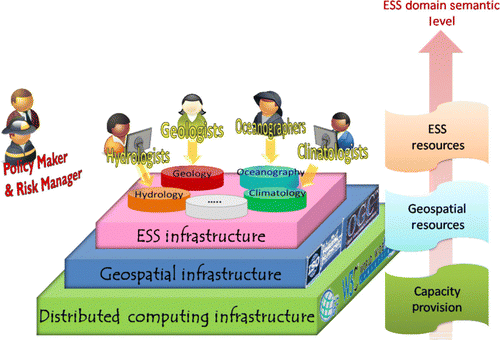
As depicted in , the ESS infrastructure builds on the GI infrastructure functionalities which, in turn, are underpinned by the DC infrastructure functionalities. A resource Geosciences facet (a) qualifies the semantics expressed by its Geospatial facet (b) which, in turn, specifies the generic Digital facet (c).
In a geosciences SoS, interoperability should be achievable at all the three infrastructure levels. Existing systems may join the SoS at a given infrastructure level by implementing the technical and semantic interoperability aspects, which characterise it and the infrastructure(s) that underpin it. Naturally, the ESS interoperability level is the most effective one to support policymaking.
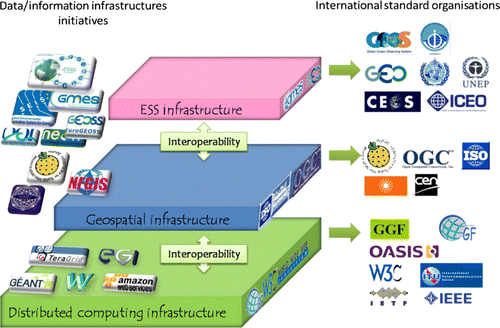
There is a clear need to establish a solid interoperability framework not only for each recognised infrastructure but also between them. As depicted in , each infrastructure interoperability is pursued by several international standard organisations; while, many recent and valuable initiatives and programmes (e.g. global monitoring SoS; national, regional and global SDI/SII); observatory systems; digital repositories systems) have been developing interoperability solutions among the different infrastructure domains. These solutions include specifications profiles, application extensions, brokering and mediation services, and cross-walks technologies.
Figure 2. Infrastructures interoperability specifications.
Information modelling approach
To apply a SoSE process, a modelling architecture approach is highly recommended (Butterfield et al. Citation2008). For effective systems federation, conceptual composability is needed. The introduced interoperability arrangements must be able to align (and where necessary to harmonise) the heterogeneous system conceptual models. On the other hand, interoperability arrangements must not require tight coupling or strong integrations: interoperability specifications should only define how system components interface with each other, thereby minimising any impact on affected systems other than interfaces. This is a clear challenge to SoS development.
Interoperability agreements (i.e. interoperability arrangements) should be based on current information technology directions: there exists an irreversible trend away from data-centric towards service-oriented architectures and systems. In the Web era, there is a clear demand to discover and access resources (whether they are data, computational elements, processing algorithms or environmental models) using Internet technologies. Therefore, each information infrastructure should define a common information reference model with mappings and translations from legacy formats onto common structures (Woolf and Nativi Citation2008).
As defined by the Object Management Group (OMG, http://www.omg.org/), MDA is a way to organise and manage enterprise architectures supported by automated tools and services for both defining the models and facilitating transformations between different model types. MDA is an approach to application design and implementation. It encourages efficient use of system models in the software development process, and supports reuse of best practices when creating families of systems. Model-driven engineering technologies offer a promising approach to address the inability of third-generation languages to alleviate the complexity of platforms and express domain concepts effectively (Schmidt Citation2006). The MDA supports a platform independent model view of interoperability solutions space and encapsulates all transformations of the solutions in terms of models.
However, MDA was developed for enterprise architectures; hence, it needs to be adapted to be applicable to SoS. In fact, SoS recognises the autonomy of the individual systems, at all the infrastructural level, not requiring tight coupling or strong integrations.
Information modelling and the geosciences community
While the information modelling approach is well-adopted by the DC and Geosciences Information communities (e.g. W3C, OASIS, OGF, ISO/TC211 and OGC communities), this approach is novel – for the most part – to the environmental and earth science communities, and there are significant challenges in bridging the conceptual gap (Nativi and Woolf Citation2009).
Recently, there has been a steady increase in interest in the application of MDA in earth and space sciences, as evidenced by the substantial investment across all disciplines by science agencies such as the US National Science Foundation and EC Research&Development Framework Programmes. Considerable intellectual innovation is occurring as a result of on data, information and knowledge sharing across traditional disciplinary boundaries (Baker et al. Citation2008). The Earth Science Communities have been implementing international open standards (such as ISO/TC211 and OGC Web Services) for discovery, access and processing of GI.
Often, these implementations specialise the general and flexible standard specifications to better address specific domains requirements and needs for interoperability – contributing to build an ESS infrastructure on the geospatial data one. Thus, these profile implementations provide for interoperability well tuned to the earth and space scientific domains – members of the same community developed the standards. In the international standardisation framework, these extension specifications are now being refined as standard best practices or application profiles – for the ESS domain.
However, applications designed for end-users and the general public require the geosciences community to be more active on the definition and experimentation of these technologies and solutions in a coordinated and multi-disciplinary way. In fact, there is a real need to enable cross-disciplinary scenarios promoting the development and adoption of standards and technologies which overcome inconsistencies and enhance the interoperability of geosciences data, information and tools. To that end, it is important to bring earth science communities together to address significant digital infrastructure issues recognising and promoting multi-disciplinary solutions. This is of great consequence to influence specifications and promote conventions in order to lead efforts for geosciences resources interoperability with GIS, Digital Earth systems, SOA-based systems and other emerging technologies.
The special session: ‘implementation of international geospatial standards for earth and space sciences event’
At the European Geosciences Union (EGU) General Assembly meeting held in Vienna (Austria) from 19 to 24 April 2009 (http://meetingorganizer.copernicus.org/EGU2009/session/1599), a special event discussed these important topics.
The session presented valuable and innovative experiences conducted by important Earth science Communities for: Geological applications, Hydrologic applications, Land Monitoring Network Services, Ocean applications, Met-Ocean applications and new data tools for Climatology.
These experiences showed some of the latest advances in implementing open standards for access to sensor data, processing of the data suitable for a specific decision or research context and presentation of the information to the various communities ranging from researchers, policymakers and the general public. The talks from the EGU event are published on the OGC network web forum (http://www.ogcnetwork.net/node/525). The main session objectives were:
-
To discuss the integration of information systems from different geoscience disciplines, addressing the heterogeneity that characterises its: data and metadata models, protocols, interfaces, semantics and embedded knowledge.
-
To promote and discusses the present process to scale from specific and monolithic systems (data-systems-centric) towards independent and modular (service-oriented) enabling infrastructures – forming an ESS infrastructure. This approach aims to provide scientists, researchers and decision-makers with a persistent set of independent services and information that scientists can integrate into a range of more complex analyses.
-
To support the geosciences community to leverage the recent revolution in information and communication technologies (ICT) – e.g. MDA, SOA, semi-structured data model and encodings.
-
To show some of the latest advances in implementing open standards for access to sensor data, processing of the data suitable for a specific decision or research context, and presentation of the information to the various communities ranging from researchers, policymakers and the general public.
-
To capture the discussion by the workshop participants and provide it as additional feedback to the SoS initiatives (e.g. GEOSS, GMES, INSPIRE) and standards bodies (e.g. ISO/TC211, OGC, INSPIRE IR, etc.) to further advance the interoperability arrangements applicability to earth and space sciences.
-
Disciplinary Structural/Schematic Models (e.g. WaterML, GeoSciML, CDI, CSML, ncML).
-
Disciplinary Application Profiles and Extension Package specifications for standard services (e.g. CS-W, WFS, WMS, WCS).
-
Disciplinary related brokering, mediation and chaining solutions (SeaDataNet broker/GI-cat, FTS service chaining).
-
Disciplinary on-going infrastructure experiences (One Geology, Cuahsi HIS, SeaDataNet, GeoLand2, SOSI, MyOcean, WIS, MOTIIVE).
Conclusions and future opportunities
Digital earth information systems play an important role to fill the existing gap between science and society and serve policymakers. These systems underpin a new vision for science called: e-Science addressing global challenges. Several international and European initiatives have been developing these information infrastructures (e.g. GEOSS, GMES, INSPIRE). They adopt the SoS paradigm, which applies an information modelling approach by implementing interoperability arrangements that do not require tight coupling or strong integrations. Relaxation of MDA solutions must be investigated to achieve effective interoperability arrangements.
A SoS must build on existing information infrastructures. As for semantics and technology aspects, each information infrastructure must comprise consistent resources/components to deliver effective interoperability. Digital Earth should make use of SoS technology to accelerate information transfer from theoretical discussions to applications, in all fields related to global climate change, natural disaster prevention and response, new energy-source development, agricultural and food security, and urban planning and management.
For designing a geosciences SoS, three main information infrastructures can be recognised:
-
the ESS information infrastructure;
-
the GI infrastructure; and
-
the DC information infrastructure.
Therefore, the earth sciences community are required to develop an holistic multi-disciplinary approach to model, discover, access and use geosciences resources – i.e. data, services, models, semantics. This holistic approach must be harmonised with the international standards for interoperability (e.g. ISO/TC211 and OGC). Society's applications urge the earth sciences community to be more active on the definition and experimentation of these interoperability solutions in a coordinated and multi-disciplinary way. In fact, a model driven approach raises the level of abstraction to cope with systems complexity. MDA provides a framework that can be applied to web service development; process models are an accepted part of service oriented process design. However, this approach must be adapted to meet the interoperability arrangements requirement to connect SoS components avoiding tight coupling or strong integrations. The services sector has grown over the last 50 years to dominate economic activity in most advanced industrial economies, yet scientific understanding of modern services is rudimentary: there is a clear requirement for a services science discipline to integrate across scientific silos (Chesbrough and Spohrer Citation2006).
The second-generation web technologies (Web 2.0) promise to provide complexity-hiding and reuse, along with the concept of loosely coupling services (Schroth and Janner Citation2007); they are the complementary aspects to SOA required by scientists. A combination of principles from both Web 2.0 and SOA can facilitate the wide dissemination of many resources. Datasets and services that are accessible via the Web can be discovered, annotated (i.e. tagged), and also mashed up (i.e. composed and interlinked with the goal of designing new resources) according to the users’ requirements (O'Really Citation2005). Enterprise mashups represent a valuable use case of an Internet of Services (IoS) architecture that could easily be situated at the interstice of Web 2.0 and SOA (Mulholland et al. Citation2006). Mashup platforms let users retrieve content or functionality from arbitrary sources, mix it with other resources and expose it for further reuse by other applications (Schroth and Janner Citation2007). Web Mashup approaches would empower scientists and researchers to model and deploy business models in an extremely quick and efficient fashion.
Other IoS valuable examples affect professional business applications – e.g. applications that can be leveraged by trading partners to initiate business-to-business transactions. Mass marketing techniques can leverage the networking opportunities offered by the Web 2.0 social networking sites and applications. For scientists and researchers, the networking capabilities offered by Web 2.0 facilitate the meeting of potential users, research partners and strategic alliances.
Through the development of new classes of software, algorithms and hardware, data-intensive applications may provide timely and meaningful analytical results in response to exponentially growing data complexity and associated analysis requirements (Kouzes et al. Citation2009). This evolution is essential to address the deluge of data that SoS (and scientific applications) must process, and creates a compelling argument for substantially increased research and development targeted at discovering scalable hardware and software solutions for scientific data-intensive problems (Gorton et al. Citation2008).
However, the information modelling approach is novel to the earth sciences community and there exist significant challenges in bridging the conceptual gap.
EGU-ESSI and OGC organised a special event to bring earth science communities together and address significant digital infrastructure issues recognising and promoting multi-disciplinary solutions. Significant experiences were showed and some of the latest advances in implementing open interoperability standards were discussed. The event was very successful; the organisers are planning to hold such events on a regular basis. The manuscripts published in this IJDE issue cover most of the talks given at the event. They cover significant developments for different earth science disciplines.
Notes on contributor
Stefano Nativi received the first and second (Laurea) degree in electronic engineering (telecommunications field) and the Ph.D. degree in ‘methods and technologies for environmental monitoring’ from the University of Florence, Florence, Italy. He was appointed as a PDRA Grant from the University of Bristol, Bristol, UK. He is currently the Coordinator of the Earth and Space Science Informatics Laboratory, Institute of Methodologies for Environmental Analysis, Italian National Research Council, Florence, where he is also a Coordinator of the National Interuniversity Consortium for Telecommunications Operational Unit. He is adjunct Professor of the University of Padua, Padua, Italy, teaching ‘systems for land management’ for the informatics specialist degree (Faculty of Mathematics). Dr. Nativi is the President of the Earth and Space Science Informatics division of the European Geosciences Union. He is a member of the IEEE Standards Working Group of ICEO and of IEEE GRSS Data Archiving and Distribution Technical Committee. He is co-PI of the OGC GALEON Interoperability Experiment (Geo-interface to Atmosphere, Land, Earth, Ocean netCDF) and a member of the Web Coverage Service standard working group. He co-leads the GEOSS IP3 initiative and is is the lead of the GEO Standard and Interoperability Forum (SIF) European Team. He is a member of the “Metadata Core Drafting Team” for the Implementing Rules of the INSPIRE (INfrastructure for Spatial InfoRmation in Europe) European directive. He is a co-chair of the GEO Science and Technology Committee.
Acknowledgements
The author would like to thank the reviewers for their comments that helped to improve this manuscript.
References
- Adams , K. , Keating , C.B. Padilla , J.J. , 2008 . System of Systems Engineering requirements: challenges and guidelines . Engineering Management Journal . Available from: http://findarticles.com/p/articles/mi_qa5394/is_200812/ai_n31428982/?tag=content;col1[Accessed 13 March 2010] .
- Baker , D.N. 2008 . Informatics and the 2007–2008 electronic geophysical year, EOS transactions . American Geophysical Union , 89 ( 48 ) : 485 – 500 .
- Butterfield , M.L. , Pearlman , J. Vickroy , S.C. , 2008 . A System-of-Systems Engineering GEOSS Architectural Approach . IEEE GEOSS Paper .
- Chesbrough , H. and Spohrer , J. 2006 . A research manifesto for services science . Communications of the ACM , 49 ( 7 ) : 35 – 40 .
- Dilauro , T. , 2004 . Choosing the components of a digital infrastructure . First Monday , 9 (5). Available from: http://131.193.153.231/www/issues/issue9_5/dilauro/index.html[Accessed 18 March 2010] .
- European Commission , 2006 . Communication from the Commission to the Council and the European Parliament: interoperability for Pan-European eGovernment Services . COM (2006) 45 final, Brussels .
- Foster , I. and Kesselman , C. 2006 . Scaling system-level science: scientific exploration and IT implications . IEEE Computer , 39 ( 11 ) : 31 – 39 .
- Gorton , I. 2008 . Data-intensive computing in the 21st century . IEEE Computer , 41 ( 4 ) : 30 – 32 .
- Group on Earth Observations , 2005 . Global Earth Observation System of Systems (GEOSS) 10-year implementation plan . In : B. Battrick . The Netherlands : ESA Publications Division .
- International Society for Digital Earth (ISDE) , 2009 . 2009 Beijing declaration on digital earth, final declaration of the 6th international symposium on digital earth , 12 September 2009, Beijing, China .
- Jamshidi , M. , 2005 . System-of-Systems Engineering – a definition, IEEE SMC 2005 . 10–12 October, Big Island, Hawaii. Available from: http://ieeesmc2005.unm.edu/SoSE_Defn.htm[Accessed 18 March 2010] .
- Kouzes , R.T. 2009 . The changing paradigm of data-intensive computing . IEEE Computer , 42 ( 1 ) : 26 – 34 .
- Mulholland , A. , Thomas , C.S. and Kurchina , P. 2006 . Mashup Corporations: the end of business as usual , New York : Evolved Technologist Press .
- Nativi , S. and Domenico , B. 2009 . Enabling interoperability for digital earth: coverage access services . International Journal of Digital Earth , 2 ( Suppl. 1 ) : 79 – 104 .
- Nativi , S. Fox , P. , 2010 . Advocating for the use of informatics in the earth and space sciences . EOS Transactions, American Geophysical Union , 91 8 , 75 76 .
- Nativi , S. Woolf , A. , 2009 . An holistic view of coverage model and services for SISE-SEIS . In : Proceedings of the European conference of the Czech Presidency of the Council of the EU towards environment. Opportunities of SEIS and SISE: integrating environmental knowledge in Europe , March 2009, Masaryk University, Brno, Czech Republic. ISBN 978-80-210-4824-9 .
- Nativi , S. , Ramamurthy , M. Woolf , A. 2009 . Towards earth and space science digital infrastructures: network, computing and data services . International Journal of Digital Earth , 2 (Suppl. 1) , 1 2 .
- O'Really , T. , 2005 . What is Web 2.0: design parameters and business models for the next generation of software . Available from: http://www.oreillynet.com/pub/a/oreilly/tim/news/2005/09/30/what-is-web-20.html[Accessed 18 March 2010] .
- Percivall , G. , 2010 . The application of open standards to enhance the interoperability of geoscience information . International Journal of Digital Earth , 3 Suppl. 1 , 14 30 .
- Schmidt , D.C. 2006 . Guest editor's introduction: model-driven engineering . IEEE Computer , 39 ( 2 ) : 25 – 31 .
- Schroth , C. and Janner , T. 2007 . Web 2.0 and SOA: converging concepts enabling the internet of services . IEEE IT Professional , 9 ( 3 ) : 36 – 41 .
- Woolf , A. Nativi , S. , 2008 . How earth science can contribute to, and benefit from, the SII . USA: CRC Press. In : Creating spatial information infrastructures towards the spatial semantic web . Taylor & Francis .