Abstract
Risk communication is a significant challenge in risk management. It serves different purposes; an important one is to improve the public risk awareness and mitigation. Because of the strong spatio-temporal component of natural hazards, maps can play a decisive role in communicating risk information. The application and design of maps for risk communication especially to the public has not been investigated comprehensively. Specific constraints and challenges of risk communication have not been considered systematically in the map design process so far. This study aims at developing a frame for the application and design of interactive risk and hazard maps for the public which is based on the specific constraints and challenges of risk communication. In a literature review it introduces concepts and methods from social sciences and psychology, which have been assessed as important for communicating risk information. The concepts and methods are adapted to map-mediated risk communication according to the approaches of Activity Theory. Communication objectives and tasks which are essential to improve risk mitigation are identified and geovisualization methods for information presentation are related according to the degree which they are able to serve them. Based on this, some principles for map-based risk communication are established.
1. Introduction
1.1. Risk communication
Risk communication is an integral part of risk management. ‘It is an interactive process of exchange of information and opinion among individuals, groups, and institutions. It involves multiple messages about the nature of risk and other messages, not strictly about risks, that express concerns, opinions, or reactions to risk messages or to legal and institutional arrangements for risk management’ (National Research Council 1989, p. 21 in Wiedemann and Schütz Citation2000, p. 2). Risk communication plays a vital role in risk reduction. Disasters are most likely when there is a lack of public awareness about conditions and human actions that can make individuals, groups, and communities vulnerable. Therefore, one challenge of risk communication can be seen as the effort to convince people that a risk is real, to describe what its characteristics are and to provide information on what can be done about it (Lundgren and McMakin Citation1998, Citation2009). Therefore, risk communication can be considered as a contribution to the Digital Earth initiative which aims at providing information for monitoring and acting on the planet Earth.
The risk of a specific hazard in a defined area is the central idea in modern risk-management concepts. In a colloquial sense it characterizes the possibility of a loss resulting from exposure to a hazard; in a scientific context it encompasses the probability and the amount of harmful consequences or expected losses resulting from interactions between natural or human-induced hazards and vulnerable conditions (Centre for Disaster Management and Risk Reduction Technology Citation2008). In this paper risk is used in the scientific sense.
Risk management is an approach to deal with natural hazards. It is derived from security science and has changed the pure security thinking into an interdisciplinary culture that deals with risk on different levels and involves all stakeholders (Kuhlmann Citation1995). Risk management encompasses disaster response during a hazard event, recovery, risk analysis, and assessment as well as risk reduction, which is primarily aimed at preventing and mitigating damage (Kienholz et al. Citation2004). Although risk communication has to support all of these sub-processes, one task has to be pointed out, which is to improve risk mitigation. A communication campaign should make the public aware of its vulnerability to a particular risk and inform it about the most effective protection measures. Decision makers as well as laypeople, who may be affected by natural or man-made hazards, have to understand the hazard itself, its impact and the potential of protecting themselves from a disaster. This knowledge forms a basis for dealing responsibly with hazards. The need for more effort in communicating risks to the public was also formulated in an article published in Nature Editorial (Citation2005) ‘Scientist who study these risks have a critical and valuable role to play in ensuring that every effort is made to raise public and political awareness. The effective communication of risk is a non-trivial problem […] one can not always expect local policy-makers and planners to delve directly into scientific literature for information. So imaginative approaches are needed to forge effective links between the two groups.’
Risk communication is not a trivial process. In order to design effective risk communication strategies, various aspects have to be considered: the general concepts which have been developed in the field of information communication as well as the specific constraints and challenges which are related to communicating risk information. A general frame of map-based communication is formulated in a model of the cartographic communication process (Kolacny Citation1969). It shows the relevant components and their relationships in the cartographic communication process: the information which has to be communicated, the medium – in our case the map – which conveys the information, the map maker who encodes the information into the map according to specific rules and according to the application purpose, and the audience who has to decode the information with respect to its objectives, context, and knowledge. The specific constraints and challenges of risk communication have been investigated in several studies from psychology and social sciences (Covello Citation1991, Citation1993, Renn and Levin Citation1991, Slovic et al. Citation2004). Wiedemann and Schütz (Citation2008) have recently summarized determining the parameters of successful risk communication campaigns: these are aspects of psychology of disasters, communication process, information presentation, and type of information source.
1.2. Maps in risk communication
Natural hazards have a strong spatio-temporal component, therefore maps can play a decisive role in risk communication. As part of a holistic campaign, maps may contribute to improving awareness and understanding. Different types of maps have been developed, dealing with hazards or risks, like the Swiss hazard maps or the German risk maps of insurance companies (Dransch et al. Citation2005). The variety of maps related to hazards and risks is impressively shown in Monmonier's (Citation1997) book ‘Cartographies of danger.’ It gives a comprehensive overview about existing maps on different hazards and risks in the USA. The term map is used in this paper in a broad sense. It includes two- and three-dimensional visualizations and dynamic simulations, and it covers paper maps, interactive maps as well as map-based information systems.
The usefulness of maps in risk communication is acknowledged in many fields. ‘Representation and analysis of disease incidence data in map form has now established itself as a basic tool within the realm of public health and environmental justice’ (Maclachlan et al. Citation2007, p. 73). Various countries, for instance Germany, Austria, Switzerland, The Netherlands, or Great Britain, have started creating maps for different hazards and risks. The European Directive on the Assessment and Management on Flood Risks (EU Flood Directive Citation2007) demands detailed and extensive maps depicting flood hazard or risk as a measure against flood damage.
Besides traditional paper maps, digital maps, map-based information systems, simulations, and web-technology are increasingly applied in risk communication (Maclachlan et al. Citation2007, Hagemeier-Klose and Wagner Citation2008, Haubrock et al. Citation2008). Although criticism arises concerning availability and accessibility of information provided via the Internet, recent research work points out that the Web may democratize the access to risk information especially if open-access and open-source technology is used (Curtis and Mills Citation2008). Digital, interactive maps and information systems offer more potential for information presentation, exploration, and analysis. However, the larger the options, the more a careful design of the maps is required. Investigations have shown that various user-needs for risk communication via the Web exist (Rohrmann Citation2004). Essential aspects are the design of visual components, easily understandable content, the offer of further information and a self-explaining, easy to use interface (Hagemeier-Klose and Wagner Citation2009).
Various aspects of maps for risk management have been investigated so far. The design of map symbols for crisis management was analyzed (Dymon Citation2003, Conger Citation2004). Hazard and risk maps were distinguished into different categories according to their content and complexity (Merz and Gocht Citation2003), and concepts for risk maps were developed like the risk and protection deficit map (Egli Citation2000). Some work focused on user orientation and demands on hazard and risk maps (Dapp Citation2002, Dransch and Etter Citation2006, Haubrock et al. Citation2008). Human-centered GIS user-interfaces (Rauschert et al. Citation2002, Müller et al. Citation2007) as well as maps and GIS supporting collaboration in risk management (MacEachren et al. Citation2004, Cai et al. Citation2005) are further fields of research.
Most of this work is either directed at crisis management and the involved stakeholders or at authorities who have to deal with a risk, e.g. planning or water authority. The public, who is to be considered also as a stakeholder, is seldom subject of investigation. This limitation is also found when regarding existing hazard and risk maps. Most of them are created for scientists, risk-management experts, insurances, and authorities but not for laypeople (Curtis and Mills Citation2008).
The investigation and design of hazard and risk maps was guided predominately by the cartographers and risk-management professionals and their thematic focus. Fruitful knowledge has been created in order to design hazard and risk maps; however, the findings from psychology and social sciences regarding specific constraints and challenges of risk communication have not been considered systematically in the map design process.
1.3. Rationale for this study
In our research we address this shortcoming. The objective of the paper is to complement the well-established cartographic knowledge about information presentation with specific aspects of risk communication. We investigate the following questions: how can maps contribute to the specific challenges of risk communication to the public? How are maps to be designed to meet the particular requirements of communicating risk information to the public? A frame of communication objectives, tasks, and suitable map application and design is established.
This paper is structured as follows: in Section 2, we outline the methodical approach of our study. Section 3 introduces the challenges we found to be important to communicating risk information. These common challenges are transferred to map-mediated risk communication to laypeople (Section 4). Then the paper ends with a discussion and conclusions for further research.
2. Methodology
A literature review was undertaken to develop a sound understanding of aspects influencing the effectiveness of risk communication. Challenges related to risk perception, communication process, and information presentation were derived. A frame was established that relates the challenges to our research focus, the map-mediated risk communication to the public. Communication objectives for the target group were formulated and tasks which have to be fulfilled to reach the objectives were determined. In a further step it was demonstrated how maps can support the tasks and how they have to be designed for a specific task. This methodological approach follows the theoretical concept of Activity Theory (Nardi Citation1996, Dransch Citation2001), which forms the basis for the task-oriented approach (Andrienko and Andrienko Citation2005) applied in modern geovisualization to achieve a suitable map design. According to Activity Theory, each activity is described by objectives, which direct an activity, and by tasks, which are necessary to reach the objectives. The tasks are operationalized by actions into executable components. Activity Theory is applied in many disciplines to study and formalize physical as well as mental activities.
3. Challenges of risk communication – a literature review
The challenges of risk communication have been investigated in social sciences and psychology. They can be distinguished into challenges related to risk perception, the communication process, and information design.
3.1. Challenges related to risk perception
Often people react to a hazard warning with incredulity and continue their normal activity. This phenomenon is called normalcy bias (Gutteling and Wiegman Citation1996). It causes people to underestimate the possibility of being affected by a hazard. This often results in situations where people fail to adequately prepare for hazards. According to Perry (Citation1979), people's behavior in a hazard situation depends highly on the individual risk assessment, the perceived threat as well as community aspects. If a hazard occurs unexpectedly and people are not prepared, they react with incredulity. If individuals realize the danger, they will ask for more information to assess the situation and they will act to reduce the risk. Due to the persons’ knowledge about potential protection measures, they can act to minimize the risk. From these findings the following points can be derived for risk communication:
-
Improve risk perception of people in vulnerable regions.
-
Enhance knowledge about the hazard itself and warning signals.
-
Give concrete information about a hazard such as location or time.
-
Make information about suitable protection measures available.
-
Keep information and warnings consistent in order to be reliable.
Another difference in dealing with risk exists between experts and laypeople. Wiedemann and Schütz (Citation2000) point out the different framing of risk by experts and laypeople. Experts consider risk as characteristics and effect of hazard potential. They deal with suspected hazard, accident potential, exposure to hazard, and attribution of effects; risks are described by qualitative and quantitative measures. In contrast, laypeople frame risk issues in a more personal way. They usually put risks in a broader social context and they organize their knowledge in a story-like manner. The mental models describing the risk conceptions of laypeople differ widely from those of experts (Morgan et al. Citation2002). Mileti (Disasters Citation2003) also mentions that people will tend to believe risk messages when they can confirm them through interactions with significant others, such as family members, friends, and co-workers. Risk communication has to be aware of these differences; it has to bridge the gap before addressing risk information.
A further aspect which affects risk perception is trust and credibility. Factors which influence credibility are for instance comprehensive and consistent information, experience and professional attainment, truthfulness and objectivity as well as involvement. Also the problem of false alarm has to be mentioned here. Information about a hazard event has to be true; otherwise, people will not trust further alarms and will not react to the information. Credibility is the basis for any risk communication. Only if credibility is given, information and education will work (Renn and Levin Citation1991, Covello Citation1993, Slovic Citation1993).
3.2. Challenges related to the communication process
Risk communication has to concentrate on the most important target group. This so-called primary audience (Lundgren and McMakin Citation1998) can be the group of most affected people, the people who are least informed about a hazard, its consequences, and protection potential, or the persons who are most involved in the decision process how to handle a risk. The design of risk communication should focus on the requirements of the primary audience. Closely related to the primary audience are the communication objectives (Dransch Citation2001, Citation2003). The communication's intention has to be defined and the media has to be designed accordingly. A further aspect is the information source, which is used in the communication process. The choice of an information source by the audience is determined by the following factors: its availability and accessibility, the effort and money which is necessary to contact it, the experience a person already has with the source, and its credibility (Gutteling and Wiegman Citation1996, Curtis and Mills Citation2008).
3.3. Challenges related to information presentation
Vivid information presentation plays a crucial role in effective risk communication. According to the concept of vividness, vivid information may improve memorability and construction of mental representations. It also may amplify the emotional involvement of a person. This is especially true for people who are not informed or concerned as experts and professionals (Weidenmann Citation1991). ‘Information may be described as vivid, that is, as likely to attract and hold our attention, and to excite the imagination to the extent that it is (a) emotionally interesting, (b) concrete and imagery-provoking, and (c) proximate in a sensory, temporal, or spatial way’ (Taylor and Thompson Citation1982, p. 156). As research has shown, localized hazard information, e.g. pictures showing former disasters in the home community, is remembered longer than more impressive pictures from other areas (Wagner Citation2007). Vividness can be realized by using a precise and concrete language, showing pictures and graphs, or by giving individual case histories. Vividness refers to the content as well as the presentation of information. Investigations comparing numerical and graphical information presentation have demonstrated that pictorial information is helpful for risk understanding and it affects the willingness to reduce risks (Fuller et al. Citation2002, Schirillo and Stone Citation2005). It is assumed that vivid information has greater influence in decision making than other types of information (Taylor and Thompson Citation1982).
Reducing and adapting the complexity of a message to the particular audience is another vital aspect of risk communication (Gutteling and Wiegman Citation1996). In a study examining the influence of different communication means (written or spoken text, video, PC) for understanding scientific risk information it became apparent that the more interactive and user-oriented the communication material, the better the information is understood (Trevena et al. Citation2006). Enabling the audience to understand the content of a message is of great importance. If people do not understand the message entirely, the consequences on their attitude and behavior are unpredictable.
The interpretation of a message and the conclusion derived from it may also vary according to the wording of a message. Tversky and Kahneman (Citation1981) investigated the phenomenon of message framing in the context of risk communication: positive and negative formulation of a message may change the reaction of people greatly. Tversky and Kahnemann could show in their experiment that positive wording (e.g. gain, to save lives) leads to risk-averse behavior; in contrast, negative wording (e.g. lost, people will die) causes risk taking. The influence of negative or positive wording on risk perception is confirmed by investigations conducted by Flugstad and Windshitl (Citation2003). Finally, the certainty effect has to be considered when formulating risk messages. This effect is defined as following: ‘a reduction of the probability of an outcome by a constant factor has more impact when the outcome was initially certain than when it was merely probable’ (Tversky and Kahneman Citation1981, pp. 454–455). Another relevant issue in message framing is the formulation of a hazard's or risk's probability. A study could demonstrate that laypeople prefer relative frequency as a measure for hazard and risk probability (Gosh and Gosh Citation2005).
Comparing risks may help people to improve the assessment of a risk (Covello Citation1991). The comparison should be related to other risks or standards, to different times or places, to other affected groups, or to taking or not taking actions against a risk (Lundgren and McMakin Citation1998). The goal of risk comparison is to improve understanding of quantities, illustrate the magnitude of a risk, illustrate the significance of the risk, or explain the uncertainties in risk management (Wiedemann and Schütz Citation2000).
Finally, the concept of many-sidedness has to be considered. Many-sidedness means to present all aspects of a certain topic, in our case of a risk (Gutteling and Wiegman Citation1996). Positive as well as negative aspects have to be published to allow the audience to create a differentiated view of a risk. Also doubts, inconsistencies or uncertainty of information should be communicated. Depicting uncertainty of information, however, has different results: part of the audience feels informed more honestly and comprehensively, others interpret uncertainty as incompetence and dishonesty (Johnson und Slovic Citation1995).
3.4. Summarizing the challenges
The challenges which have to be met by risk communication exist on different levels. The aspects which are related to risk perception show how individuals react to hazard and risk information, how they assess it, and how they deal with it. They evince the constraints of the audience and determine the requirements on communication goals and media design. The aspects concerning the risk communication process emphasize the importance of a defined target group, determined communication goals, as well as a reliable and accessible information source. They are the three corner stones of an effective risk communication campaign. The issues of information presentation demonstrate the influence of a certain style of information depiction on the way individuals understand and interpret risk information. They give indications on the design of effective media.
4. Supporting the challenges of risk communication with suitable maps
In the following a frame is developed which relates the general results from the literature review to the specific focus of our research. Communication objectives, tasks, and methods for suitable map design are formulated.
4.1. Communication objectives and tasks
The primary audience for our investigation is the public. Although we are aware that the public is not a homogeneous group, and that cultural and personal differences have to be considered, we assume that general requirements for the design of hazard and risk maps have to be fulfilled in order to improve risk communication to the public. The audience is often distinguished between experts and laypeople (Slovic Citation1987, Siegrist und Gutscher Citation2006). Following this differentiation, we suppose that maps defined for laypeople can be adopted for the general public as well, in spite of existing differences.
For this target group we defined the communication purpose, which is to improve risk mitigation behavior. We derived the related communication objectives from challenges described in the literature review. The introduced normalcy bias and the hazard vs. outrage phenomenon demand improving risk perception and assessment. The specific risk framing of laypeople makes it necessary to allow a personal view on risks, which can be confirmed with others. And finally, the need for trust as a precondition for all communication requires establishing credibility. According to these needs, we defined three main objectives for risk communication to the public and subdivided them into tasks. The first objective is to improve risk perception; the tasks are to increase risk knowledge and understanding, to enable appropriate risk assessment, and to allow good information accessibility. The second objective is to support a personal risk framing; the tasks are to create a personal view and to allow confirming information with others through interaction. The third objective is to establish credibility; the tasks are to inform objectively and to give consistent information. The realization of the objectives and tasks by maps is demonstrated in the following sections. With respect to the generality of the frame we do not distinguish maps for different hazards.
4.2. Maps to improve risk perception
4.2.1. Maps to increase knowledge and understanding
Vivid and emotionally interesting maps can support this task. They should depict concrete information about the impact of a hazard, e.g. the influence at a person's house or at least the area where the person lives. The spatial reference map should be detailed enough to enable individuals to identify places that they are interested in, such as single houses or living areas. Moreover, pictorial media such as aerial photos, realistic representations, or city models are useful because objects look more realistic and are easier to recognize for untrained people (Weidenmann Citation1988). Associative colors and symbols must be applied in order to allow users a quick and correct information extraction. Some existing risk maps do not follow these cartographic rules and therewith hamper map reading. Furthermore, additional information presenting concrete hazard events or experiences at certain locations should be linked to the map in order to add emotional information, such as pictures, videos, or spoken reports of witnesses.
Scenarios of past or possible future events can also contribute to vivid information presentation. Therefore, interactive maps should be combined with digital databases and simulation models to create different scenarios allowing a person to explore the risk and to get deeper insight into the hazard and its possible effects. As investigations have shown, the scenarios should be alterable by the users according to known measurable values for a hazard, e.g. gauge level for flood or wind speed for storm (Hagemeier-Klose and Wagner Citation2009).
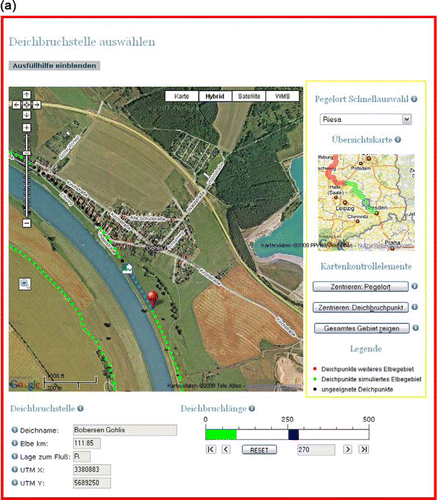
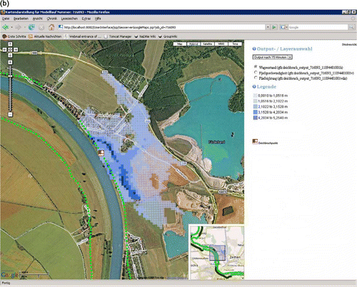
We have implemented several of the described design guidelines in a map-based simulation tool for the German Elbe River, which allows people to explore the impact of floods and a related dike breach (a and b). The simulation tool should enable laypeople to assess the effects of a dike breach at a defined place and flood level. It should make apparent the potential vulnerability of areas behind a dike. A simulation model composing a hydraulic and a dike breach model forms the basis. It calculates the height of the flood according to a chosen gauge level as well as the flooded area in the case of a dike breach at a defined place. The input of the model consists of two parameters: the height of the flood at a certain gauge and the place where the dike breach occurs. The output presents the area which will be flooded as well as the depth of the water in relation to time. In order to make the simulation models’ input and output understandable for laypeople a suitable visualization and interaction design was implemented. People are able to interact with the flood simulation tool via an Internet browser. The area of the Elbe River is presented using Google satellite maps. Many people who use the Internet are familiar with Google and Google Maps. The dikes are added with a green dot line. On the satellite map users can interactively select the location of a dike breach with a mouse click; a bar chart beneath the map allows them to determine the width of the dike breach (a). The gauge level as a further input parameter can be defined either via a selection button to choose predefined scenarios, e.g. historical flood events, or via a column graph to set individual values. The model output is laid over the Google satellite map to present the result of the model run for the user (b). All model outputs can be overlaid over the map in a loop to display the temporal development of the model run. Individuals are able to see the impact of a dike breach on the place where they live. One problem which is related to scenarios is the inaccuracy of models. Inaccurate information foils effective risk communication as the principle of credibility demonstrates. In a recent research project we investigate how uncertainty and different data quality can be communicated effectively.
Figure 1. (a) Flood and dike breach scenario tool: determining the dike breach location. (b) Flood and dike breach scenario tool: simulation results.
Maps which should improve risk perception have to depict information not only in a vivid manner but also in a suitable complexity. Cartographic rules about comprehensible symbolization, suitable presentation method, and adequate number of presented topics should be applied. Maps can also assist in organizing information and thus, avoid information overload. As an information portal an interactive map may join different information components and link them to specific locations on the map. For instance, information about actions that people can take for risk mitigation in an area affected by flood or storm can be linked to areas which are exposed to these hazards. This option allows for providing further information which people may access very flexibly according to their individual interest.
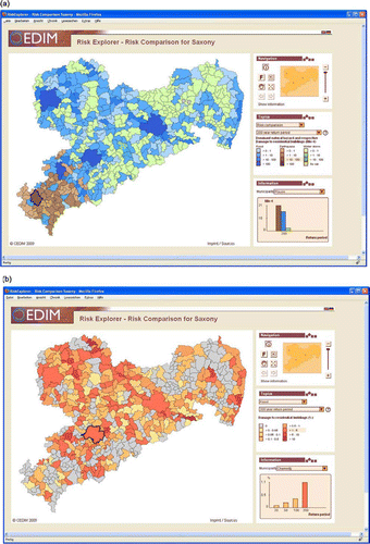
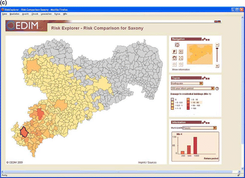
The interactivity of a map should be determined and guided by the communication goal and tasks. It should be restricted to those functionalities which contribute to knowledge creation. In the flood and dike breach simulation tool (a) interactivity is limited to defining the input parameter for the simulation, the dike breach location and the gauge level. In the risk assessment tool for Saxony (a–c), the interactivity allows users to choose a particular area of interest, a hazard and a return period, and to navigate in the map. Supplementary interactions, such as changing the map design, should be avoided in order to allow people to concentrate on the essential aspects and to keep the interaction with an interactive map simple and clear.
Figure 2. (a) Risk comparison tool: comparison of all existing hazards. (b) Risk comparison tool: comparison of the risk of flood with a 200 year return period. (c) Risk comparison tool: comparison of the risk of earthquake with a 200 year return period.
4.2.2. Maps to enable appropriate risk assessment
Maps are effective means for risk assessment with spatial dimensions. They can illustrate the magnitude of a risk and its spatial distribution as well as the significance of a risk. The following categories of risk comparisons should be applied in maps:
-
Comparison of the same risk at different places.
-
Comparison of the same risk at different times.
-
Comparison of areas of risk against a specific standard, which show areas of lower or higher risk than the standard.
-
Comparison of different risks at a certain place.
-
Comparison of a risk when acting or not acting in space (e.g. dike breach, retention areas).
-
Comparison of alternative solutions to the same problem.
-
Comparison of average risk with peak risk at a particular time and location.
In a tool called Risk Explorer we have developed an interactive map-based information system which allows people to assess different risks in the area of Saxony, a federal state of Germany. The predominant hazard which people relate with Saxony is flood because of disastrous flood events caused by the Elbe river. However, Saxony is not only affected by floods but also by storms and earthquakes. These hazards receive less attention than floods because of the rare occurrence in the case of earthquakes or the more local appearance in the case of storms. With respect to a more realistic assessment of the various hazards and related risks we have designed interactive maps that enable people to compare the three hazards and their risk in Saxony. All hazards were related to the same return period of 200 years, which is a prerequisite for the risk comparison. One type of maps shows the spatial distribution of the predominant hazard and the related damages to residential buildings (a). This map makes apparent the regions which are affected primarily by floods, earthquakes, or storms. An additional diagram located in the legend box allows for comparing the quantities of all three hazards for selected places. Another type of map presents the expected damage of one selected hazard for various return periods. b and c show exemplarily the expected damage of a flood or earthquake event to residential buildings in Euros. In this case the additional diagram compares the damages of different hazard probabilities.
4.2.3. Maps to allow good information accessibility
The Internet is a suitable medium to present hazard and risk maps to the public. In Germany for instance 72% of households were connected to the Internet in 2009 (Statistisches Bundesamt Citation2009). Web mapping can be implemented based on different technologies. Web mapping services and Google Maps are popular solutions. Open Geoinformation Consortium (OGC) compliant Web Map Services (WMS) allow for a customized and flexible compilation of datasets on the one hand, and the exact definition of map layouts on the other. As WMS interfaces are standardized, using this approach enables a flexible combination of multiple distributed data repositories for compiling maps. Also client applications are able to use WMS without further knowledge about the data source. Vector and raster data can be structured in the form of layers and combined in the service. Some drawbacks of implementing WMS are the common lack of appropriate background datasets and the effort for setting up sophisticated, scale-dependent map compilations.
On the other hand, Google Maps provides an application interface (API) that allows for an easy integration of pre-defined background maps based on an enormously comprehensive and up-to-date data basis. The open API makes an integration of standard Google Maps in the browser an easy task. The rendering time is much faster compared to current WMS implementations on the market. Using Google Maps as a background layer therefore makes the compilation of web maps efficient and can add to their quality. The major limitation of Google Maps – although the API has constantly been extended and improved – is the missing possibility to set up customized, highly sophisticated maps that directly include data from standard resources, such as spatial data bases or GIS file formats.
Based on the advantages and limitations of these technologies, a synthesis of both has been used for implementing the flood and dike breach simulation system (a and b). The Google Maps client interface has been chosen as control elements because it is commonly well-known and its integration into web pages is straightforward. The simulation results represent customized, classified data sets that are dynamically growing with each simulation result. These data are stored in a spatial data base, which is accessed by a WMS. At the client side, the simulation data is queried from the WMS and combined with Google Maps background layers in order to set up a multi-layer map with all the information needed for both orientation and thematic interpretation.
4.3. Maps to support personal risk framing
4.3.1. Maps to create a personal view
Personalized maps and contextual information presentation are means to support this requirement. Interactive hazard and risk maps should allow for individuals to select the area which they are interested in by address or place name. This functionality is well-known from tools such as Google Maps or navigation systems. The maps could also be aligned and centered according to this address, a selected house or area should be highlighted. The risk explorer presented above meets the challenge of a personalized view. Users are able to select municipalities in which they are interested via name or by a mouse click in the map. The place will be highlighted in the map. Additionally, the related diagram which depicts the expected damage for different hazards or for one hazard with different return periods will be adapted to the chosen municipality (a–c). Supplementary information, which is specific for a selected area, e.g. specific protection measures or nearby information points, should be offered either in the map or in a separate information block.
4.3.2. Maps to allow confirming information with others through interaction
Interactive maps which allow exploration of a risk by personal views and the creation of different scenarios could be a means to support discussion and confirmation with others. Different views on a hazard or risk yield arguments for conversation and discussion. Examples for interactive hazard and risk maps are given in and . Also the possibility for adding personal information to a map, such as pictures, reports, or even data of an individual hazard experience, allows people to confirm information and should be offered as a means of improving risk awareness. The US Geological Service (USGS) for instance makes use of such personal information. It involves people in the creation of earthquake intensity maps by its map service ‘Did you feel it?’ (CitationUSGS Did you feel it). People are asked via a web-based user interface to deliver information about a recent earthquake, the requested data are the basis to create earthquake intensity maps. Another example is the map created by the BBC during a severe flood in England in 2007. Personal pictures and videos taken by individuals from the flood are tagged to a Google Map to show the impact of the hazard (CitationBBC Google Map).
4.4. Maps to establish credibility
4.4.1. Maps to inform objectively
Hazard and risk information can be communicated very objectively by maps. They depict the spatial distribution, quality, and quantity of hazards and risks. One example is the German risk map (CitationCEDIM). Maps also allow a comprehensive view on hazards and risks. Various map scales may show the local, regional, or national level of a hazard; local or regional comparisons of risks allow for assessing a person's exposure.
4.4.2. Maps to give consistent information
Hazard and risk information is not always consistent, especially during a hazard event. Often information is vague and becomes clear only gradually. An example is the route of a hurricane. The possible route is calculated from multi-run simulations showing the results of different simulations. Maps may present the different simulation results to show the uncertainty of information. This may help people to get more insight in the varying status of information and may support assessing given risk information more correctly. It also decreases the danger of false alarm. This type of map can be applied for instance to weather forecasts. A further requirement for a consistent map design is to make maps comparable with each other; they should be designed with similar signs and depict comparable content and object models. The maps we have created to support risk assessment in Saxony (a–c) meet these requirements. All hazards are referred to a return period of 200 years and the graphical design is consistent for all maps.
The introduced frame for map-mediated risk communication is summarized in .
Table 1. Frame for map-mediated risk communication to the public.
5. Discussion
In our research work we have developed a frame for the application and design of hazard and risk maps, which put its focus predominately on the challenges and restrictions of risk communication that have been investigated in scientific studies from social sciences and psychology. Thus, it expands the previous view on risk maps which was mainly guided by a cartographic and risk expert perspective. The extended view allows a more comprehensive understanding about the requirements maps have to fulfill in order to support successful risk communication. It makes apparent the conditions of communicating risk information and how maps can contribute to meet the various challenges. By adopting the methodical approach of Activity Theory to formulate objectives, tasks, and suitable visualization methods, the challenges and constraints of risk communication have been systematized; principles for map application and map design are derived. In addition, with already existing cartographic knowledge, the established frame can form a basis for the application and design of effective hazard and risk maps.
In future studies the principles we have formulated in the frame have to be fully implemented and tested to what extent they can support the described communication objectives. Tests which investigate the accomplishment of different tasks could support this research. The advantages of interactive hazard and risk maps provided on the Internet could already be confirmed by a study of Hagemeier-Klose and Wagner (Citation2009). The research of the paper contributes to a recent scientific as well as societal challenge of improving risk understanding and preparedness of people in order to decrease their vulnerability to natural hazards.
Notes on contributors
Doris Dransch is a Professor for Geoinformation Management and Visualization at Helmholtz Centre Potsdam, German Research Centre for Earth Science, and Humboldt-Universität in Berlin, Germany. She received her PhD in Geography in 1995 and her Habilitation in Geoinformatics and Geovisualization in 2002 from the Freie Universität Berlin. Her research interests include geoinformatics for risk management as well as interactive geovisualization and visual analytics.
Henry Rotzoll is a researcher at German Aerospace Center (DLR). He received a Diploma degree in Geography with minors in Geoinformatics, Transportation Science, and Economics from the Humboldt-Universität in Berlin, Germany, in 2008. In 2009 he earned a masters degree in Computing from the University of York, UK. His research interests include software and system development, geovisualization well as spatial data structures, and the analysis of spatial data.
Kathrin Poser is a researcher at the Center for Disaster Management and Risk Reduction Technology at the German Research Centre for Geosciences (GFZ), Potsdam, Germany. She received a Diploma in Geoecology from the University of Potsdam, Germany and a MSc in Photogrammetry and Geoinformatics from the University of Applied Sciences in Stuttgart, Germany. Her research interests include geomatics for natural disaster management, Internet GIS, and spatial data quality.
References
- Andrienko , G. and Andrienko , N. 2005 . Exploratory analysis of spatial and temporal data. A systematic approach , Berlin : Springer .
- BBC Google map Available from: http://maps.google.com/maps/ms?ie=UTF8&hl=en&msa=0&ll=51.507033,-0.942078&spn=0.363271,0.925598&z=10&om=1&msid=110697284745114202648.000435deadb5810139523 [Accessed 26 February 2010]
- Cai G. et al. 2005 Map-mediated geocollaborative crisis management Paper presented at the 3rd IEEE international conference on intelligence and security informatics ISI, May 2005 Atlanta, GA. Lecture Notes in Computer Science, 3495/2005. Berlin: Springer 429 435
- CEDIM Risk explorer [online]. Available from: http://www.cedim.de/riskexplorer.php [Accessed 26 February 2010]
- Centre for Disaster Management and Risk Reduction Technology 2008 Glossary [online]. Available from: http://www.cedim.de/english/905.php/ [Accessed 26 Februray 2010]
- Conger S. 2004 A review of colour and cartography in avalanche danger visualization Paper presented at the international snow science workshop, 19–24 September 2004, Jackson Hole, WY
- Covello , V.T. 1991 . “ Risk comparison and risk communication. Issues and problems incoparing helath and environmetal risks ” . In Communicating risks to the public. International perspectives , Edited by: Kasperson , R.E. and Stallen , P.J.M. Dodrecht : Kluwer Academic Press .
- Covello , V.T. 1993 . “ Communicating risk information: a guide to environmental communication in crisis and noncrisis situations ” . In Environmental strategies handbook: a guide to effective policies and practices , Edited by: Kolluru , Rao V. 497 – 514 . New York : McGraw-Hill .
- Curtis , A. and Mills , J.W. 2008 . Geospatial approaches for disease risk communication in marginalized communities . Progress in Community Health Partnerships: Research, Education, and Action , 2.1 : 61 – 72 .
- Dapp K. 2002 Informationsmanagement in der Planung am Bespiel des vorsorgenden Hochwasserschutzes Schriftenreihe des Instituts für Wasserversorgung, Abwasserbeseitigung und Raumplanung Thesis (PhD). Universität Darmstadt
- Disasters R. 2003 Alerting America Effective risk communication. Report on the roundtable workshop No. 6, Alerting America. Effective risk communication. October 2002 . Washington, DC National Academies Press
- Dransch D. 2001 User-centered human–computer interaction in cartographic information processing Paper presented at the 20th international cartographic conference, 6–10 August Beijing, China
- Dransch , D. 2003 . Handeln mit Karten. Grundzüge einer handlungsorientierten Kartographie . Kartographische Nachrichten , 2003 ( 6 ) : 266 – 270 .
- Dransch D. Etter J. 2006 Gefahren- und Risikokarten–eine akteursorientierte Perspektive, Aktuelle Entwicklungen in Geoinformation und Visualisierung: GEOVIS 2006 (Hazard and risks map – an actor-oriented perspective, proceedings of GEOVIS 2006), 5. bis 6. April, Potsdam, Kirschbaum 63 72
- Dransch D. Etter J. Walz U. 2005 Maps for natural risk management Paper presented at the 22nd international cartographic conference, 9-16 July La Coruna, Spain
- Dymon , U.J. 2003 . An analysis of emergency map symbology . International Journal of Emergency Management , 1 ( 3 ) : 227 – 237 .
- Egli T. 2000 Gefahrenkarten für die Bauvorsorge und Notfallplanung Paper presented at the Workshop Vorbeugender Hochwasserschutz auf kommunaler Ebene, 13-14 December Dresden, Germany
- EU Flood Directive 2007 [online]. Available from: http://eur-lex.europa.eu/LexUriServ/LexUriServ.do?uri=CELEX:32007L0060:EN:NOT [Accessed 26 February 2010]
- Flugstad , A.R. and Windshitl , P.D. 2003 . The influence of reasons on interpretations of probability forecasts . Journal of Behavioral Decision Making , 16 ( 2 ) : 107 – 126 .
- Fuller , R. , Dudley , N. and Blacktop , J. 2002 . How informed is consent? Understanding of pictorial and verbal probability information by medical inpatients . Postgraduate Medical Journal , 78 ( 923 ) : 543 – 544 .
- Gosh , A.K. and Gosh , K. 2005 . Translating evidence-based information into effective risk communication: current challenges and opportunities . Journal of Laboratory and clinical Medicine , 145 ( 4 ) : 171 – 180 .
- Gutteling , J.M. and Wiegman , O. 1996 . Exploring risk communication , Dordrecht : Kluwer Academic .
- Hagemeier-Klose , M. and Wagner , K. 2008 . Experten-evaluation von web-GIS-lösungen und Internetkartendiensten zur Kommunikation von Hochwasserinformationen . Geographica Helvetica , 63 ( 2 ) : 94 – 103 .
- Hagemeier-Klose , M. and Wagner , K. 2009 . Evaluation of flood hazard maps in print and web mapping services as information tools in flood risk communication . Natural Hazards and Earth System Science , 9 : 563 – 574 .
- Haubrock , S. , Dransch , D. and Plattner , S. 2008 . “ Maps in the natural disasters networking plattform NaDiNe – meeting the user's needs: form static images to highly interactive real-time information integration ” . In International perspectives on maps and the Internet , Edited by: Peterson , M.P. 251 – 266 . Berlin : Springer-Verlag .
- Johnson , B. and Slovic , P. 1995 . Presenting uncertainty in health risk assessment: initial studies of its effects on risk perception and trust . Risk Analysis , 15 ( 4 ) : 485 – 494 .
- Kienholz , H. 2004 . Aspects of integral risk management in practice-considerations with respect to mountain hazards in Switzerland . Österreichische Wasser- und Abfallwirtschaft , 56 : 43 – 50 .
- Kolacny A. 1969 Cartographic information - a fundamental concept and term in modern cartography International Yearbook of Cartography 186 193
- Kuhlmann , A. 1995 . Einführung in die Sicherheitswirtschaft , Verlag TÜV Rheinland .
- Lundgren , R. and McMakin , A.H. 1998 . Risk communication: a handbook for communication environmental, safety, and health risks , 2nd and 4th ed , Columbus : Batelle Press .
- Lundgren , R.E. and McMakin , A.H. 2009 . Risk communication. A handbook for communicating environmental, safety and health risks, 4th edition , Hoboken, New Jersey : Wiley .
- MacEachren A.M. et al. 2004 Geocollaborative crisis management (GCCM): building better systems through advanced technology and deep understanding of technology-enabled group work Paper presented at project highlights abstract, proceedings, 5th annual NSF digital government conference, 24-26 May Seattle, WA
- Maclachlan , J.C. 2007 . Mapping health on the internet: a new tool for environmental justice and public health research . Health and Place , 13 : 72 – 86 .
- Merz , B. and Gocht , M. 2003 . Karten für die Hochwasservorsorge und das Risikomanagement auf der lokalen Skala . Hydrologie und Wasserbewirtschaftung , 47 ( 5 ) : 186 – 194 .
- Monmonier , M. 1997 . Cartographies of danger: mapping hazards in America , Chicago, IL : University of Chicago Press .
- Morgan , M.G. 2002 . Risk communication: a mental models approach , New York : Cambridge University Press .
- Müller M. et al. 2007 Spatial GUIs for complex decision support in time-critical situations Paper presented at the 23rd international cartographic conference, 4-10 August Moscow, Russia
- Nardi B.A. 1996 Context and consciousness: Activity Theory and human computer interaction Cambridge The MIT Press
- Nature Editorial 2005 Preparing for disaster Nature 438 889
- Perry , R.W. 1979 . Evacuation decision-making in natural disasters . Mass Emergencies , 4 : 25 – 38 .
- Rauschert I. et al. 2002 Designing a human-centered, multimodal GIS interface to support emergency management Paper presented at the 10th ACM international symposium on advances in geographic information systems, 8-9 November McLean, VA
- Renn , O. and Levin , D. 1991 . “ Credibility and trust in risk communication ” . In Communicating risks to the public international perspectives , Edited by: Kasperson , R.E. and Stallen , P.J.M. 175 – 218 . Dordrecht : Kluwer University Press .
- Rohrmann B. 2004 The relevance of the internet for enhancing disaster preparedness of residents Paper presented at 11th annual TIEMS conference – the international emergency management society, Yarra Ranges
- Sandman , P.M. 1989 . “ Hazard versus outrage in the public perception of risk ” . In Effective risk communication: the role and responsibility of government and nongovernment organizations , Edited by: Convello , V.T. , McCallum , D.B. and Pavlova , M. 45 – 49 . Washington, DC : Plenum Press .
- Sandman , P.M. , Weinstein , N.D. and Miller , P. 1994 . High risk or low: how location on a risk ladder affects perceived risk . Risk Analysis , 14 ( 1 ) : 35 – 45 .
- Schirillo , L.A. and Stone , E.R. 2005 . The greater ability of graphical versus numerical displays to increase risk avoidance involves a common mechanism . Risk Analysis , 25 ( 3 ) : 555 – 566 .
- Siegrist , M. and Gutscher , H. 2006 . Flooding risks: a comparison of lay people's perceptions and expert's assessments in Switzerland . Risk Analysis , 26 ( 4 ) : 971 – 979 .
- Slovic , P. 1987 . Perception of risk . SCIENCE , 236 : 280 – 285 .
- Slovic , P. 1993 . Perceived risk, trust and democracy . Risk Analysis , 13 : 675 – 682 .
- Slovic , P. 2004 . Risk as analysis and risk as felleins: some thoughts about affect, reasoning, risk, and rationality . Risk Analysis , 24 ( 2 ) : 311 – 322 .
- Statistisches Bundesamt 2009 [online]. Available from: http://www.destatis.de/jetspeed/portal/cms/Sites/destatis/Internet/DE/Presse/pm/2009/12/PD09__464__IKT.psml [Accessed 26 February 2010]
- Taylor , S.E. and Thompson , S.C. 1982 . Stalking the elusive ‘Vividness’ effect . Psychological Review , 89 ( 2 ) : 155 – 181 .
- Trevena , L.J. 2006 . A systematic review on communicating with patients about evidence . Journal of Evaluation in Clinical Practice , 12 ( 1 ) : 13 – 23 .
- Tversky , A. and Kahneman , D. 1981 . The framing of decision and the psychology of choice . Science , 211 : 453 – 458 .
- USGS Did you feel it [online]. Available from: http://earthquake.usgs.gov/earthquakes/dyfi/ [Accessed 26 February 2010]
- Wagner , K. 2007 . Mental models of flash floods and landslides . Risk Analysis , 27 ( 3 ) : 671 – 682 .
- Weidenmann B. 1988 Psychische Prozesse beim Verstehen von Bildern (Understanding pictures-mental processes) Bern Huber
- Weidenmann B. 1991 Lernen mit Bildmedien. Mit den Augen lernen (Learning with pictorial media) Bern Huber
- Wiedemann P.M. Schütz H. 2000 Developing dialogue-based communication programmes Arbeiten zur Risikokommunikation 79
- Wiedemann P.M. Schütz H. 2008 Risikokommunikation als Aufklärung: Informieren über und erklären von Risiken (Risk communication as means of education. Informing about and explaining risks) E.D. Lantermann V. Linneweber Enzyklopädie der Psychologie Umweltpsychologie – Bd. 1. (Vol. 2, Serie IX) Göttingen Hogrefe