Abstract
Sensor Web has been widely promoted and its application has evolved from original military usages to current ubiquitous civil and commercial applications. Its emergence has become a great strength to facilitate the Digital Earth concept. Although many Sensor Web applications and methods have been proposed to assist disaster management, they are not well suited to the unique features and application requirements of disaster management. Most researches focus on how to use the Sensor Web to monitor a certain phenomenon before a disaster happens and to provide early warning. However, there is a lack of study on the negative effects that a disaster may bring to the Sensor Web. For example, severe weather conditions, damaged infrastructure, and spatial isolation may directly make the Sensor Web out-of-service. Besides, disaster management is a complex subject and its domain knowledge needs to be clarified. In this paper, the domain of the disaster management is explored and its unique features are analyzed. Then the Sensor Web concept and its role in disaster management are explained. Afterwards, the challenges of the Sensor Web for disaster management and the possible solutions are discussed. Based on the above, we introduce a high-mobility emergency system to demonstrate a good solution of the Sensor Web for multi-purpose disaster management.
Introduction
Gross made a very interesting assertion that in the next century, planet earth will don an electronic skin (Gross Citation1999). The skin consists of a huge amount of embedded electronic measuring devices communicating via the Internet, such as thermostats, pressure gauges, pollution detectors, cameras, microphones, glucose sensors, EKGs, and electroencephalographs. Thus, the earth will have awareness about the cities, the endangered species, the atmosphere, the transportation, our bodies, and even our dreams. A similar concept emerged as the so-called ‘Internet of Things’ (IoT) is being paid more and more attention worldwide. For example, the Europe Commission just released the action plan of IoT for Europe to encourage and facilitate more IoT applications in current ICT environment (EU Citation2009).
Things of IoT can be any objects, and the dialogue of thing-to-thing or thing-to-human is established through the communication of many diverse sensors. That is, the infrastructure of IoT is built on the sensor networks and its success tightly depends on the sensor technologies. Furthermore, the pervasive Web accessible sensor networks constitute the Sensor Web that can be discovered and accessed via standard protocols and application program interfaces (APIs) (Liang et al. Citation2005, Botts et al. Citation2008). The IoT can be regarded as a huge network of Internet-enabled daily objects, together with Web services that interact with these objects. The underlying technologies of the IoT are based on the fundamentals of the Sensor Web such as RFID. In this way, comparing with the IoT, the Sensor Web is more specific via using Web technology to organize and distribute sensors.
The research of the Sensor Web has taken much advantage of the development of electronic science, wireless communication technology; computer science and open standards and its applications have evolved from original military usage to civil and commercial adoption. However, the Sensor Web is still young and there are many open issues for employing it to a particular domain, because it is a highly application-specific field and the requirements and constraints of domain applications need to be well understood, otherwise there will be many impediments to employ it in the real world (Xu Citation2002). It is required to consider the domain knowledge as one indispensable factor when implementing the sensor networks (Martinez et al. Citation2004).
One of the important fields to use the Sensor Web technology is the disaster management: sensors are installed on site to monitor the underlying or possible risks, for example, flooding and forest fire (Jirka et al. Citation2009); orbital space sensors such as the satellites are used to find the hotspot for monitoring the spread of wild fires (Moodley et al. Citation2006), or to help the flood warning management (Brakenridge et al. Citation2003); the combination of space and in-situ sensors are adopted to collect both space and ground data for volcano hazard monitoring (Song et al. Citation2008). Most Sensor Web researches focus on observing a certain phenomenon in order to predict the emergency or make an alarm before the event. There is a lack in investigating the Sensor Web during an emergent event, and especially some extreme events such as earthquakes are always accompanied by serious damages to the infrastructure of sensor networks. Moreover, disaster management represents a complex domain that involves different action phases, such as the preparedness, prevention, response, and recovery. The traditional design and treatment of sensor networks could not work as the way ‘leave them and use them in the Sensor Web.’
This paper will probe into the disaster management domain to analyze the whole process, and investigate the specific requirements of disaster management. Especially when urgent events happen without clear signs and bring great damage such as severe weather conditions and communication problems, whether the Sensor Web is still working well to help the disaster response? If the existing Sensor Web is not able to help us or there are no available sensors, how could we set up a sensor network to cope with the newly arrived emergency? And how this sensor network can be easily integrated into the Sensor Web architecture?
This paper is structured as follows. First, important concepts in disaster domain are introduced. Then the state of art of the Sensor Web technology is described, and its role in disaster management is explained. Afterwards, the challenges of the Sensor Web are proposed based on the characteristics of disaster management. An example of a high-mobility sensor network is given considering the described challenges. Finally, the conclusions will be drawn.
Disaster domain
Introduction
Disaster is a broad term, and historically it was always related with the term ‘natural hazard’ which contains rapid-onset hazards like cyclones and earthquakes, or slow-onset crisis such as drought, famine, and disease (De Paratesi Citation1989). As the disaster research goes deeper, a disaster is universally acknowledged as having more elaborate meaning. A disaster may have varying magnitude, temporal and spatial dimensions and varying social and economic consequences. The importance of human factors also cannot be ignored in the disaster (Zerger and Smith Citation2003).
In this paper, we adopt the definition of disaster newly provided by the United Nations International Strategy for Disaster Reduction (UNISDR): ‘A serious disruption of the functioning of a community or a society involving widespread human, material, economic or environmental losses and impacts, which exceeds the ability of the affected community or society to cope using its own resources’ (UNISDR Citation2009). The 2009 version of the definition is achieved through a broad range of experts and practitioners in various international venues, regional discussions, and national settings.
In detail, disasters are often described as a result of a combination: the exposure to a hazard; the conditions of vulnerability that are present; and insufficient capacity or measures to reduce or cope with the potential negative consequences. Despite the different origins of disasters, their impacts share many common elements. Helbing et al. carry out terrorisms such as the research on various extreme events and summarized the impacts of disasters, such as serious traffic, transportation, and supply problems, regular trade may break down, the disaster area may be isolated from its environment and hardly reachable, even the unreliable information like inconsistent data and rumors is disseminated, and so on (Helbing et al. Citation2006). Those impacts could cause not only negative effects on people physically, mentally, and socially, but also damages to properties, destruction of assets, loss of services, not to mention social and economic disruption and environmental degradation.
According to the origins of the disasters, people classify them as natural disasters, technological disasters, and man-made disasters (or deliberate disasters). Earthquakes, floods, droughts, hurricanes, and wild fires are some examples of natural disasters. Construction accidents, transportation accidents, and industrial accidents are some examples of technological disasters. Man-made disasters mean the deliberate disasters initiated by human intent to do terrorism such as the US 911 event (Comfort Citation2005, Mansourian et al. Citation2006).
To better understand the nature of disasters and set up the suitable strategies, some nations offer more comprehensive classification of disasters. Emergency Response Law of the People's Republic of China states that there are four kinds of disasters: natural disasters; technological disasters; public health disasters; and social safety disasters. Besides, each kind of disaster is again explicitly classified as many subclasses in several levels in order to prevent the ambiguity of the general classification (China Citation2007). For example, a landslide event is one of the subclasses of geological disasters, and a geological disaster is one of the subclasses of natural disasters. A dangerous chemical leak event is one of the subclasses of dangerous chemical disasters, and a chemical disaster is one of the subclasses of technological disasters.
Even though we explicitly classify the types of disasters, a disaster in reality does not merely belong to one category since new types of disasters are often derived from it or triggered by it. For example, strong earthquakes are considered as extreme natural hazards that can bring about serious damage to the environment. Due to the big movements between terrains, other natural hazards may occur. For example, the landslides happen as rocks fall, shallow debris flow, and even worse, when it is rainy, more forces have to be put to the detritus. As a result, another disaster, the barrier lake (or debris dam or quake lake), a natural damming of a river by mass wasting from landslides, might come into being. Similarly, a city fire disaster could cause other types of disasters such as explosions or chemical leaks, if there are nearby inflammable and explosive materials or dangerous chemical sources.
Disasters are always complex. They may cause expected and unexpected results. The initial disaster and a series of derived disasters constitute a chain, and each one is likely to lead to another one. To reduce the negative effects, we have to cut off the chain. The more we study the characteristics of each type of disaster including its spatial and temporal dimensions as well as its surrounding environment, the easier we find out the possible derived disasters and prevent or prepare for them.
Overview of the disaster management researches
Disaster management is a very complex process involving a cycle of activities. It handles the organization and management of resources and responsibilities for addressing all aspects of disasters. Sometimes, the expression ‘emergency management’ is used equivalently instead of disaster management (UNISDR Citation2009). According to the time phase of a disaster, it can be regarded as three parts: pre-disaster; disaster; and post-disaster. Disaster management has to consider all the possible activities within the three time ranges. Therefore it contains monitoring, detection, and prediction of pre-disaster; response, command and control, and search and rescue during the disaster; recovery and learning a lesson of post-disaster, to name a few.
The US federal Emergency Management Agency (FEMA) has categorized four stages in a comprehensive disaster management system: Mitigation (or Prevention); Preparedness; Response; and Recovery (mostly abbreviated as PPRR, originated in the work of the State Governors’ Association in the USA (Citation1979)). Mitigation efforts mean the activities which reduce the vulnerability of life and property by lessening the impact of disasters. Preparedness efforts mean the activities of a continuous cycle of planning, organizing, training, equipping, exercising, evaluating, and taking corrective action to ensure effective coordination during incident response. Response efforts mean the activities necessary to address the immediate and short-term effects of a disaster and sometimes it is called ‘disaster relief.’ It focuses primarily on the emergency services and public assistance to save lives, to protect property, to ensure public safety and to meet the basic subsistence needs. Recovery efforts mean the activities that restore and improve facilities, livelihoods and living conditions of disaster-affected communities and try to bring communities back to normal. It also includes the activities to reduce disaster risk factors based on the lessons learnt from the disaster with consideration of mitigation and preparedness needs. The division between those stages is not clear-cut. For example, some mitigation activities such as buying fire-fighting equipment may also be employed in the training and exercising actions of preparedness stage. Some response actions, such as the supply of temporary accommodation, may also fit well into the recovery stage.
The PPRR method has been adopted in the disaster management community since it originated 30 years ago. For a long time, it did help the governments and organizations to understand the disaster management and implement corresponding strategies to deal with disasters. However, as the developments in disaster management and surrounding concepts change, so does the PPRR method. Some researchers challenge its relevance in contemporary emergency management policy. Crondstedt reviewed the rationale and policy surrounding the adoption and use of the PPRR approach, and pointed out that although PPRR has found a place in the new methodology, the fit is not neat and has inherent problems (Crondstedt Citation2002). For example, the artificial barriers of PPRR imply a clear delineation between the elements, which causes unnecessary discussions of the boundary; the elements always appear equally important in all circumstances, which cause the ‘forced’ weighting; the elements assume a sequential consideration of PPRR and force the treatments to be ordered and inextricably linked to the emergency cycle.
Because of the complexity of the disaster management, we have to manage and organize different kinds of information coming from the disaster environment, including humans, goods and materials, messages, commands and control, and all needed datasets. Information technology has always been used to help people build up the disaster management system. Information systems like the decision support system have been adopted quite early (Wallace and De Balogh Citation1985), which used the database technology, data analysis technology, modeling technology, visualization, and interactive use of the data and models technology. Other ICT methods are also investigated to facilitate the disaster management, such as using the multi-agent cooperative model (El-Korany and El-Bahnasy Citation2008) to assist the fire fighters to control the fire disaster, using the rule-based expert system together with multi-agent system to manage individual entities (e.g. rescue teams, polices, medical teams, and supply teams) and their collaborations for one task or multi-tasks (Si et al. Citation2008).
Sensor Web
Introduction
Sensor Web concept was conceived at the NASA/Jet Propulsion Laboratory (JPL) in 1997 for integrating mass spatially distributed consumer-market chips for the computer and telecommunication industries as a single instrument to acquire the collaborative results (Delin et al. Citation2005). Afterwards, many scientists have studied the concept of the Sensor Web, and have given different meanings of this term. There is not a universal definition of the Sensor Web without considering the context. The differences of those definitions are caused by the different starting points or key points. Some of them focus on the functionality of the Sensor Web and others emphasize the environments or infrastructure that support the Sensor Web (Si et al. Citation2008, Zyl et al. Citation2009).
For example, Zyl et al. explained the evolution of the Sensor Web and gave the definition of the Sensor Web from the view of pure system. Sensor Web was born to combine the sensor networks to form a single macro instrument, which can eliminate shortcomings such as the sensor networks in silos independently and the short-sighted architecture. Sensor network and sensor are regarded as a sensor resource, for example, a thermometer is a sensor and its combination with a hydrometer and a wind speed sensor represents a sensor system: weather station. The definition of the Sensor Web is therefore given as ‘the Sensor Web is an open complex adaptive system, organized as a network of open sensor resources, which pervades the Internet and provides external access to sensor resources. By open sensor resources, we include any open system, including sensor networks, that is a source of sensor data or sensor metadata.’
Si et al. mentioned the basic features of the Sensor Web should be inclusive, even though the definition may vary. It may contain the following basic features: sensing; autonomy; dynamic reconfiguration; standards-based interaction; and access. Besides, Di et al. gave two other features: interoperation and collective effect (Di et al. Citation2009). All the above features show that the Sensor Web is well suited for organizing individual sensors to realize the discovery and access of the ubiquitous sensor data. Thus, the Sensor Web is able to provide services in many different applications, from environmental studies, global warming change and land use change to medical treatments and disaster management.
Related standards
Good standards are able to facilitate the acceptance and spread of new things. Botts et al. declared ‘a Sensor Web refers to Web accessible sensor networks and archived sensor data that can be discovered and accessed using standard protocols and application program interfaces (APIs),’ which showed the importance of the standards for realizing the Sensor Web (Botts et al. Citation2007). The well-known Open Geospatial Consortium (OGC) has been active to initiate Sensor Web Enablement (SWE) via creating a set of open standards. Comparing with the Internet, the standardized work is necessary for achieving the goal of the Sensor Web. Specifically, those open standards provide mechanisms for collaboration as well as conceptual models and standardized formats for the interchange of data (Zyl et al. Citation2009). In summary, OGC SWE initiative consists of three markup languages and four-service interface standards as shown in .
Table 1. OGC SWE open standards.
The above OGC SWE standards primarily help users to publish, find, and use the sensors, and bring the sensor data to different application fields via the web. While on the sensor network level, there are another set of standards for providing approaches to interface physical transducers (sensors or actuators) to control/field networks, instrumentation systems, and microprocessors. These open sensor interface standards (which currently have seven standards, from P1451.0 to P1451.6) are developed by the Institute of Electrical and Electronics Engineers (IEEE) 1451, and they can accommodate various sensor interfacing and connecting configurations With this in mind, there is a great opportunity to apply OGC SWE and IEEE standards together to ultimately achieve the ease of use of sensors and ability to transfer sensor information from sensors to the applications in a seamless way using consensus-based standards (Lee and Reichardt Citation2005).
Furthermore, standards relating to the metadata level of the Sensor Web were investigated in order to find the right sensor at the right time and location with the right quality (Di et al. Citation2009). Metadata standards from International Organization for Standardization Technical Committee (ISO TC211), OGC and the National Aeronautics and Space Administration Global Change Master Directory were compared, and a recommendation on metadata in a pervasive web environment is derived from them.
Semantic issues about the existing OGC SWE standards were also discussed, in order to fulfill the real plug and play in the Sensor Web (Broering et al. Citation2009). Missing semantic matching between features of interest stored in a database and referred to by an observation is noticed. The same applies for the matching between observations as sensor outputs and the properties of the features of interest. The method of using semantically annotated SWE data models and service interfaces was proposed to support semantic matching.
Role of the Sensor Web in disaster management
Recently, many different kinds of low-cost, low-power, and multifunctional sensor nodes in small size and having the ability of untethered communication in short distances have been developed. The achievements are attributed to the rapid advances in wireless communications and electronics (Akyildiz et al. Citation2002). These tiny sensor nodes leverage the idea of sensor networks. Moreover, the developments in web-based sensor standards of the above introduced OGC SWE enable sensor networks evolving into the Sensor Web scope, and diverse Sensor Web applications are given birth (Jirka et al. Citation2009).
There are large amounts of Sensor Web applications being carried out for disaster management. It is possible to divide the employed sensors of those applications in several ways on different points of view, for example, from the view of the functionality, scale, duration, and others. Here, we emphasize the geo-location awareness of the Sensor Web and classify the sensors for disaster management into several types: space-based sensors; aerial-based sensors; ground-based sensors; underground-based sensors; underwater-based sensors; and creature-based sensors.
-
Space-based sensors refer to the orbital sensors like satellites. Applications are for example using the satellite images to find the hotspot for monitoring the spread of wild fires (Moodley et al. Citation2006), using multi-sensor remote sensing datasets and coupled models for dealing with the flooding, drought management, and heavy rains warning management (Brakenridge et al. Citation2003, Surendranath et al. Citation2008), and using the Shuttle Radar Topography Mission (SRTM) Digital Elevation Model (DEM) data to study the landslide hazard zonation especially in highly rugged hilly terrains (Surendranath et al. Citation2008).
-
Aerial-based sensors refer to the sensors usually installed on the plane or other flying vehicles like the Unmanned Aerial Vehicle (UAV). For example, a thermal multi-spectral scanning imager integrated on an UAV together with other instruments were adopted to provide near real-time datasets for the fire management (Ambrosia et al. Citation2003).
-
Ground-based sensors refer to the in-situ sensors, for example, air quality sensors are assembled on a bus to measure the status of air components. Smoke detectors, cameras, and thermometers were installed in buildings to monitor the fires (Jirka et al. Citation2009). Wireless sensors were distributed near the active volcanoes to monitor the volcanic eruptions (Werner-Allen et al. Citation2006).
-
Underground-based sensors refer to the sensors normally buried in the soil, ice layer, other geological stratum, or sensors integrated with the underground pipes. For example, to monitor the mad slide disaster, tensiometers for measuring the pore-water pressure were developed and installed in a point of specific depth in the soil mass (Kajimoto et al. Citation2008). To record the glaciers condition over a relatively long time and observe its changes, the scientists designed the probes comprising with pressure, temperature, and 3D-orientation sensors and installed them in the drilled holes under the ice (Martinez et al. Citation2004).
-
Underwater-based sensors refer to the sensors dropped or located in the river, lake, or sensors integrated with the underwater pipes, and the undersea sensors are included in this category. For example, water pollution sensors were installed in the river to monitor the quality of water (Jirka et al. Citation2009). People set up the undersea wireless sensor networks using acoustic undersea communication (Tavakoli et al. Citation2005).
-
Creature-based sensors refer to the sensors equipped or embedded in the human or animal bodies usually for monitoring their behaviors, health conditions, locations, and other factors. For example, sensors were equipped in the patients to automate patient monitoring like blood pressure and body temperature during emergency events (Gao et al. Citation2008). Sensors were tied to animals for tracking and controlling them (Sikka et al. Citation2004).
Challenges for the Sensor Web
The mentioned Sensor Web applications for disaster management and other existing researches mainly focus on observing a certain phenomenon in order to predict the emergency or make an alarm before the event. A disaster may cause a serious disruption of the functioning of a community or a society involving different fundamental infrastructures. The Sensor Web consisting of many spatially distributed sensors must be one of the affected things. There is a lack of research on the situation that an arrived disaster brings negative effects to the Sensor Web such as the damaged sensors and broken communication network layer. The traditional design and treatment of the Sensor Web ‘leave them and use them in the Sensor Web’ does not work properly under emergencies. Besides, whether the existing sensor resources are able to meet the requirements of managing the current disaster needs to be explored. Based on the characteristics of the disaster management and the Sensor Web, we put forward two distinct scenarios when a disaster happens.
The first scenario refers to the situation that the existing Sensor Web is able to fulfill the appointed task during the disaster management. In this case, either the sensors are out of the scope of the incidence zones and are still able to transfer the usable information to the disaster management system, or the negative effects of a disaster do not influence the functionality of the sensors. For instance, a serious forest fire may destroy many in-situ fire detector sensors, but due to the space isolation the space-based sensors such as the satellites can still monitor spread of the forest fire as usual. A threatened epidemic may cause great losses in population and economy, but has no negative impacts on the video surveillance sensor systems because the epidemic can by no means damage the machines.
The second scenario refers to the situation that the existing Sensor Web is not able to implement the appointed task during the disaster management. Several different cases may lead to this situation: first, the existing sensors or its networks are totally destroyed, for example, the mud landslide may break the electric wires or cables, so sensors are not working properly or no datasets can be transferred to the disaster management system via its communication layer. Second, no proper sensor resources are available on site to handle the arrived unexpected disasters, for example, a car carrying dangerous chemicals is exploded in a city and it consequently causes the chemical leak. However, in-situ sensors for measuring the chemical conditions do not exist. Lastly, the existing sensors cannot fully satisfy the requirements of the disaster management, for example, space-based or aerial-based sensors can acquire the images of the ground in near real-time. However, in cloudy or rainy days, the captured images might not be clear enough for the subsequent interpreting task. The immediacy of the disaster management usually does not allow too much time for the Sensor Web to acquire needed information.
The second scenario contains many difficulties and needs specific design of the Sensor Web. The disasters in this scenario are always emergent and have more serious impacts than expected. It is also very hard to predict those disaster locations since they are variable and unknown. For example, the explosions may happen anywhere in the urban or rural areas. The oil ship may leak at any location on the sea, and many natural hazards are still not fully known to humans.
We focus on the second scenario and investigate the challenges of the Sensor Web for disaster management. The challenges involve the following issues that should be considered when designing the sensor resources to deal with different emergent situations.
Communication infrastructure
One of the most typical consequences of disasters is the near or complete collapse of communications infrastructure. Comfort and Haase summarized that during hurricane Katrina, for example, in New Orleans, ordinary telephone service, electrical transmission lines, cellular phone base stations, rendering cell phones, even satellite phones were out of service during and immediately after the hurricane. In the first three days following Katrina's landfall, there was essentially no reliable means of communication to help people to coordinate their actions (Comfort and Hasse Citation2006). The severity of disruption in the communications infrastructure seriously hampered the responsible organizations’ capacity to coordinate action in collective disaster response. Even when the damage of a disaster does not totally destroy the communication infrastructure, the communications overload/congestion resulting from significantly elevated traffic generated by affected residents can be highly disturbing (Patricelli et al. Citation2009).
The disruptive results of communication infrastructure as well greatly hinder the usage of the Sensor Web. None or only part of on-site sensor datasets can be transmitted to the disaster control centers, which means the decision maker is unable to grasp the situation and coordinate the rescue teams. It is necessary to investigate the method of rapid deployment of sensor network on site immediately after the disaster. Not only can this sensor network acquire the locale datasets in real-time, but also people can use its communication layer to transfer other needed information such as voices. This method should ensure the free flow of information in any magnitude among ground units, disaster control centers, and civilian and military agencies participating in the rescue effort.
Security
Security issues of sensor datasets transferring need to be greatly assured even without disaster happening. During a disaster, rescue units and other organizations do not have enough time to question the quality of the received sensor datasets under an emergent and stressed situation. The ideal way is to ‘get it and use it.’ However, if the datasets are modified or rewritten by the unauthorized users, it will cause serious consequences. Especially the disaster itself is originated by man-made events, such as the terrorism attacks or even worse, the information attacks. Therewith, security issues need to be studied at all layers of the Sensor Web.
Accessibility
As mentioned, when a disaster happens, the space isolation may obstruct the rapid deployment of the sensor network on site. For example, on May 12th, the disastrous earthquake took place in Wenchuan County of Sichuan Province in China. It brought severe damage to the local area. During the disaster, thousands of miles of roads were so destroyed that ground vehicles such as cars, trucks, and motorcycles were not able to get into the disaster area to deliver food, materials, and rescue tools. Meanwhile, it was very difficult to get local information. Due to the bad weather with clouds and heavy rains, satellites could not capture high-quality images to report the scene of the disaster area.
Under these extreme conditions, we have to think about the approaches to easily deploy the Sensor Web in those inaccessible disaster areas. Moreover, the rugged, durable, and wearable characters of sensor resources should also be studied.
Multi-datasets acquisition and integration
Disasters consist of many different subcategories, and each category has its own characters and needs specific sensors to acquire the locale disaster datasets. For example, nuclear leak events need the sensors to be sensitive to the radiation factors, and water pollution events demand pollution detection sensors. Therewith, it is almost impossible to design and implement a type of all-purpose sensor that is able to acquire all needed information or to be adaptive for any disaster category.
Having an all-purpose sensor is an ideal thing. At present, disaster information is often collected through different types of sensors. The acquired multi-datasets may have different data formats or semantics. For disaster management, it always requires the integration of the heterogeneous sensor datasets and other spatial datasets in order to create a ‘unified emergency map’ for better assisting the emergency response. Therefore, the data integration methods need to be explored, including not only spatial datasets like vector or raster maps, but also non-spatial datasets such as on-site audios and videos.
Sensor data usability
Hazard managers, administrators, and planners involved in disaster management as well as those in decision making positions need improved methods beyond simple sensor data analysis. Poor usability of sensor data cannot be fully functioned in disaster management. Data usability in geospatial domain contains many aspects, such as famous data quality elements (e.g. positional accuracy, logical consistency, and so on), data reputation, and data popularity (Hunter et al. Citation2007). However, the roles of those data usability elements are regarded differently in different domains. In disaster management, the quick emergency response often likes the ‘timely’ datasets more than the ‘outdated’ datasets even having higher positional accuracy or better logical consistency. Therefore, we should evaluate the data usability elements of sensor datasets in different methods under specific disaster situations.
Discussion of the solutions to face the challenges
The last section discusses some specific challenges of the Sensor Web in disaster management. As new types of disasters take place, the Sensor Web will face more emerging problems. The existing Sensor Web applications usually only consider the normal state, which reduces the usability of sensors in emergent situations. To meet the challenges and make the Sensor Web better for disaster management, we have to improve many aspects of traditional ways of adopting Sensor Web. There are two approaches to make the Sensor Web more robust and useful. The first one is to consider both the normal state and abnormal state when designing the sensors. It can strengthen the defence ability and reduce the damage possibility of sensors under extreme conditions. The second one is to design specific sensor networks mainly aiming at the emergent disaster management tasks. This case is focusing on the abnormal state and may often be employed when disaster happens.
The first approach can greatly enhance the working ability of the Sensor Web under the abnormal state. However, the original intention is to implement sensors for the normal state. Therewith the pertinence of sensors for disasters is still weak. The second approach is based on the characteristics of many disasters, and its implementation is directed to solve the problems under the abnormal state. Therefore, this approach can perfectly help managing the considered explicit disasters. Of course, the exclusive design and production of the sensors cost more.
No matter which approach is discussed, we always have to consider the hardware robustness of sensors when facing the disasters. For example, the electric cable of the fire alarm sensors should be fire resistant. Considering other extreme conditions, for example, some sensors may need specific battery or power supply to resist the excessive temperatures. Moreover, the logical design of redundant sensors increases the work efficiency of the Sensor Web. For example, the communication reliability of sensors is often the bottleneck problem for the Sensor Web applications. New design scheme such as the redundancy function can be used in the sensor network to solve the problem. If the communication between two sensors is interrupted, they can use the redundancy path to send data.
The second approach aims to serve the disaster management. Disasters may occur in any unknown location and cause unexpected results. We should consider not only how to make sensors more robust, but also how to rapidly set up the sensor network as fast as we can. For example, when a city fire happens, the decision maker in the command center may need the following information for supervising the rescue response: a map of the disaster area; the distribution of the rescue teams; the locations of the surrounding fire hydrants; the on-site weather conditions; the on-site videos; the audio reports from the on-site persons; and so on. To acquire that information, we need many kinds of sensors, as well as the ability to deploy such a sensor network on site in a short time. UAVs equipped with multi-functional sensors are increasingly used in the disaster management to meet the above requirements (Ambrosia et al. Citation2003). More studies need to be explored to improve the stability and safety problem of UAV itself.
For the security issues of the Sensor Web, we should investigate the issues relating to the different networking layers, for example, the IPV6 mechanism for the Internet Layer, secured HTTP protocol for the Application Layer and other layers (inter-sensor-networking stack proposed by (Zyl et al. Citation2009)). Different layers involve distinct protocols that need to be separately studied.
Although it is difficult to design an all-purpose sensor, it is possible that we step by step gain an insight into the properties of each kind of disaster. We can create a sensor repository which includes not only the common sensors such as cameras and video recorders, but also particular sensors such as nuclear detectors. Meanwhile, some of the sensors can be easily assembled and installed into an integrated sensor to implement a complex task. When a disaster happens, appropriate sensors are searched in the depository and a temporary emergent sensor network is rapidly assembled and deployed for the locale disaster area. The standardization issue determines the success of assembling various sensors into an integrated sensor or a sensor network. Without explicit standards, it is hard to realize the communications between sensors. As explained above, OGC SWE and IEEE have put much effort into standardization work to facilitate the use of sensor resources. Following those accepted standards definitely helps us to adopt multiple sensor resources in disaster management. Moreover, semantic issues and metadata issues also need to be considered to achieve the real plug-and-play Sensor Web (Broering et al. Citation2009, Di et al. Citation2009).
Moreover, faced with the heterogonous datasets collected by the sensors, it is necessary to integrate them and make a ‘unified emergency map.’ Integration of datasets is able to facilitate the data usability, e.g. a complex and aggregate emergency map definitely plays a significant role to assist the end users (or non-experts) to make the judgments in a short time or under press. In more detail, geospatial technology of Digital Earth has been proven crucial for effective disaster management, including traditional GIS-based technologies (Zerger and Smith Citation2003, McCarthy et al. Citation2008), human–GIS interaction issues (Cai et al. Citation2006), 3D GIS solutions (Zlatanova et al. Citation2004, Kwan and Lee Citation2005), spatial data infrastructure considerations (Mansourian et al. Citation2006, Zlatanova Citation2008, Mayer and Zipf Citation2009), and other GI science issues (Cutter Citation2003). Disaster management and Sensor Web are becoming important research issues in the Digital Earth concept.
An example of the Sensor Web for multi-purpose disaster management
With the consideration of the discussed solutions for improving the Sensor Web for disaster management, our research center has spent several years in investigating a sensor network with high mobility and extensibility for different disaster applications. Using sensor technology, geospatial technology, communication technology, and disaster domain knowledge, an Emergency Airship Monitoring System (EAMS) has been implemented, which is able to solve such problems as inaccessible locations, broken communication, unknown places, lack of rich information in an urgent event. It can provide accurate, straightforward, synthetical, and on-site information to the end users in real-time.
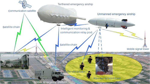
The architecture of EAMS is illustrated in . According to its main functions, it can be divided as three sub systems: Automatic Aviation and Long Distance Monitoring System, Intelligent Scanning and Positioning System, and Airdrop-based Data Collection System. According to the proposed classification of the sensors, it has the combination of aerial-based, space-based, and ground-based sensors.
Figure 1. Emergency Airship Monitoring System architecture.
Automatic Aviation and Long Distance Monitoring System
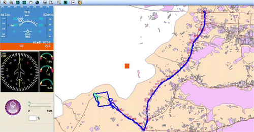
This system enables the airship to fly to the disaster area according to the pre-defined flight route of an emergency task. The command center can observe the airship's real-time location, direction, speed, fuel mass and other information in a GIS-based control system, and users can alter and edit the flying routes via user-friendly tools according to the current situation as illustrated in .
Figure 2. Flight routes of airship.
Intelligent Scanning and Positioning System
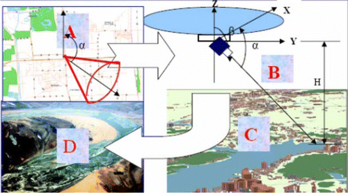
This system integrates GIS, GPS, digital compass, and image/video processing technologies to provide the bidirectional positioning between maps and monitoring images or videos. Command center can receive real-time on-site images or videos through the camera carried by the airship. On the one hand, users click the object in the image or video and will get the matched feature on the map. On the other hand, users click the feature on the map and the matched object in the captured image or video is automatically found and highlighted. If the object is not within the scope of the camera, the camera can be intelligently adjusted to the target via calculating its position. The workflow of this system is shown in .
Figure 3. Intelligent Scanning and Positioning System (A=map, B=camera, C=observed area, D=image or video).
Airdrop-based Data Collection System
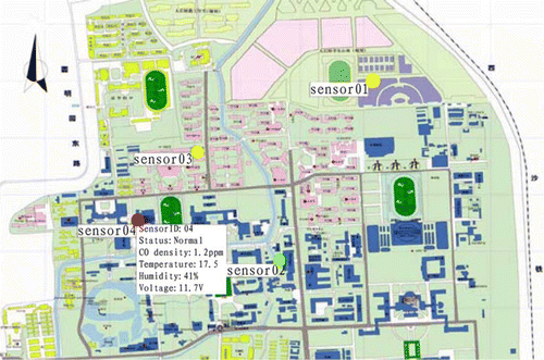
The airship can collect the images or videos information via its camera to the command center. It is also equipped with many air-drop sensors in order to collect environmental parameters such as density, temperature, moisture, and others datasets. This kind of design can solve such problems as the inaccessible locations and severe weather conditions. The air-drop sensors slow down by the parachutes in order to protect themselves as shown in . The locations of spatially distributed air-drop sensors are transmitted to the command center and visualized on the map, and their observing datasets are also shown on the map as illustrated in .
Figure 4. Airdrop-based data collection system.
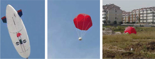
Figure 5. Air-drop sensors information display on the map.
The airship has its natural advantages: it flies stably and can be easily controlled remotely; it has low requirements for the takeoff site; it does not cause serious damage to the ground objects or humans when it crashes; it costs less than other UAVs; it has a powerful cruising radius (Khoury and Gillett Citation2004). The introduced EAMS has the following features: it can be rapidly deployed to any urban or rural areas; the robust airdrop-based sensors can be placed in an inaccessible area to collect the datasets; the encryption communication method ensures the data security; GIS based multiple datasets integration (videos, audios, images, maps, environmental parameters, and others) provides a good usability. In this way, the EAMS can be widely employed in many kinds of disaster tasks: the geological disaster monitoring such as the earthquake; environment monitoring such as radiation detection; fire monitoring; traffic accident data collection; and daily and emergency patrol. The architecture can be easily extended to meet more disaster management requirements.
However, EAMS still exposes some deficiencies due to some special disaster conditions: the wind level influences the dynamics of the airship due to the energy of the vehicle motion itself, the energy of the air around the airship and the energy added to the buoyancy air (Raul Azinheira et al. Citation2002), and the wind resistance is normally within the wind level 5–6; the airship flying speed is relatively low and maximum speed is within 70 km/h; it needs half an hour or more to finish the inflation before takeoff. Some shortcomings determine that EAMS does not work well under extreme weather conditions. Some shortcomings delay the deployment of EAMS, but time is always crucial to any emergency response.
Conclusions
The situation of IoT or Sensor Web is similar to that of the Internet 30 years ago, or of Digital Earth 10 years ago. It is still in its early stage but already shows its great potential to change our life. In the disaster domain, the Sensor Web is playing a significant role and its applications can be divided into several categories according to its geo-location awareness such as space-based sensors, aerial-based sensors, ground-based sensors, underground-based sensors, underwater-based sensors, and creature-based sensors.
A disaster may cause a serious disruption of the Sensor Web so that some or all of the existing sensors are disabled, or in some cases, no pre-installed sensor resources are available. The complex consequences of disasters bring several challenges to the Sensor Web: communication infrastructure; accessibility; security; multi-datasets acquisition and integration; and sensor data usability. With this in mind, an example of high-mobility Emergent Airship Monitoring System for multi-purpose disaster management is introduced. As the developments of sensor technology, computer science, geospatial technology, and related technologies, the Sensor Web will be able to better serve the disaster management in many aspects.
Notes on contributors
Fei Wang is a Postdoctoral fellow at the Center for Public Safety Research, Tsinghua University, Beijing, P.R. China. He received his Dr. -Ing degree from the Bundeswehr University Munich, Germany. His current research fields involve disaster management via geospatial technologies, Sensor Web, spatial data quality, and geocollaboration.
Hongyong Yuan is a Professor at the Center for Public Safety Research in Tsinghua University, Beijing, P.R. China. His research fields include emergency science and technology of public safety, disaster detection and control engineering, performance-based safety analysis and evaluation, and others.
References
- Akyildiz , I. 2002 . A survey on sensor networks . IEEE Communications Magazine , 40 ( 8 ) : 102 – 114 .
- Ambrosia , V. 2003 . Demonstrating UAV-acquired real-time thermal data over fires . Photogrammetric Engineering and Remote Sensing , 69 ( 4 ) : 391 – 402 .
- Botts M Robin A. 2007 OpenGIS Sensor Model Language (SensorML) OGC implementation specification. Open Geospatial Consortium Inc
- Botts M. et al. 2007 OGC sensor web enablement: overview and high level architecture OGC 07-165. OGC White Paper, Open Geospatial Consortium 14
- Botts , M. 2008 . OGC (R) sensor web enablement: overview and high level architecture . Lecture Notes in Computer Science , 4540 : 175 – 190 .
- Brakenridge G. et al. . 2003 Flood warnings, flood disaster assessments, and flood hazard reduction: the roles of orbital remote sensing 30th international symposium on remote sensing of environment, November 2003, Honolulu, HI
- Broering , A. 2009 . Semantic challenges for sensor plug and play . Lecture Notes in Computer Science , 5886 : 72 – 86 .
- Cai , G. 2006 . Human-GIS interaction issues in crisis response . International Journal of Risk Assessment and Management , 6 ( 4 ) : 388 – 407 .
- China P.R. 2007 Emergency response law of the People's Republic of China [online]. Available from: http://www.gov.cn/flfg/2007-08/30/content_732593.htm [Accessed 22 April 2010]
- Comfort , L. 2005 . Risk, security, and disaster management . Annual Review of Political Science , 8 : 335 – 356 .
- Comfort , L. and Haase , T. 2006 . Communication, coherence, and collective action: the impact of Hurricane Katrina on communications infrastructure . Public Works Management & Policy , 10 ( 4 ) : 328 – 343 .
- Cox S. 2006 Observations and measurements Open Geospatial Consortium Best Practices Document. Open Geospatial Consortium Inc
- Crondstedt , M. 2002 . Prevention, preparedness, response, recovery – an outdated concept? . Australian Journal of Emergency Management , 17 ( 2 ) : 10 – 13 .
- Cutter , S. 2003 . GI science, disasters, and emergency management . Transactions in GIS , 7 ( 4 ) : 439 – 446 .
- Delin , K. 2005 . Environmental studies with the sensor web: principles and practice . Sensors , 5 ( 1–2 ) : 103 – 117 .
- De Paratesi , S. 1989 . “ Hazards and disasters: concepts and challenges ” . In Remote sensing for hazard monitoring and disaster assessment: marine and coastal applications in the Mediterranean region , Edited by: Barrett , E. C. 1 – 17 . CRC Press .
- Di , L. , Moe , K.L. and Yu (Eugene) , G. 2009 . Metadata requirements analysis for the emerging Sensor Web . International Journal of Digital Earth , 2 ( 1 ) : 3 – 17 .
- El-Korany A El-Bahnasy K. 2008 A multi-agent cooperative model for crisis management system Proceedings of the 7th WSEAS international conference on artificial intelligence, knowledge engineering and data bases, February 2008, Cambridge, UK 170 175
- EU 2009 Internet of things – an action plan for Europe Communication to the European Parliament, the Council, the EESC and the committee of the Regions
- Gao T. et al. 2008 Wireless medical sensor networks in emergency response: implementation and pilot results Proceedings of 2008 IEEE international conference on technologies for homeland security. May 2008, Waltham, MA
- Gross N. 1999 The Earth will don an electronic skin [online]. Available from: http://www.businessweek.com/1999/99_35/b3644024.htm [Accessed 22 September 2009]
- Havens S. 2006 OpenGIS Transducer Markup Language Encoding Specification OpenGIS Implementation Specification Open Geospatial Consortium Inc
- Helbing , D. , Ammoser , H. and Kuhnert , C. 2006 . “ 15 disasters as extreme events and the importance of network interactions for disaster response management ” . In Extreme events in nature and society , Edited by: Albeverio , S. , Jentsch , V. and Kantz , H. 319 – 348 . Berlin : Springer .
- Hunter , G.J. , De Bruin , S. and Bregt , A. 2007 . “ Improving the usability of spatial information products and services ” . In The European Information Society: leading the way with geo-information (AGILE 2007) , Edited by: Fabrikant , S. and Wachowicz , M. 405 – 418 . Berlin : Springer .
- Jirka S. Broering A. Stasch C. 2009 Applying OGC sensor web enablement to risk monitoring and disaster management GSDI 11th world conference, June 2009, Rotterdam, The Netherlands
- Kajimoto K. et al. 2008 Sensor network to monitor underground state transition against mad slide disaster Proceedings of the 12th WSEAS international conference on computers, July 2008, Heraklion, Greece 115 121
- Khoury , G. and Gillett , J. 2004 . Airship technology , London : Cambridge University Press .
- Kwan , M. and Lee , J. 2005 . Emergency response after 9/11: the potential of real-time 3D GIS for quick emergency response in micro-spatial environments . Computers, Environment and Urban Systems , 29 ( 2 ) : 93 – 113 .
- Lee , K. and Reichardt , M. 2005 . Open standards for homeland security sensor networks . IEEE Instrumentation & Measurement Magazine , 8 ( 5 ) : 14 – 21 .
- Liang , S. , Croitoru , A. and Tao , C. 2005 . A distributed geospatial infrastructure for Sensor Web . Computers and Geosciences , 31 ( 2 ) : 221 – 231 .
- Mansourian , A. 2006 . Using SDI and web-based system to facilitate disaster management . Computers and Geosciences , 32 ( 3 ) : 303 – 315 .
- Martinez , K. , Hart , J. and Ong , R. 2004 . Environmental sensor networks . IEEE Computer , 37 ( 8 ) : 50 – 56 .
- Mayer C Zipf A. 2009 Integration and visualization of dynamic sensor data into 3D spatial data infrastructures in a standardized way GeoViz 2009. Contribution of geovisualization to the concept of the digital city, March 2009, Hamburg, Germany
- McCarthy , J. , Graniero , P. and Rozic , S. 2008 . An integrated GIS-expert system framework for live hazard monitoring and detection . Sensors , 8 : 830 – 846 .
- Moodley D. et al. 2006 Using the sensor web to detect and monitor the spread of wild fires Proceedings of the 2nd international symposium on geographic information for disaster management (Gi4DM), September 2006, Goa, India
- Na A Priest M. 2006 Sensor observation service OGC implementation specification Open Geospatial Consortium Inc
- Patricelli , F. 2009 . Disaster management and mitigation: the telecommunications infrastructure . Disasters , 33 ( 1 ) : 23 – 37 .
- Raul Azinheira , J. , Carneiro De Paiva , E. and Siqueira Bueno , S. 2002 . Influence of wind speed on airship dynamics . Journal of Guidance, Control, and Dynamics , 25 ( 6 ) : 1116 – 1124 .
- Si X. Li J. Wang Z. 2008 Knowledge-oriented sensor web for disaster management: from sensing to decision making The international archives of the photogrammetry, remote sensing and spatial information sciences Beijing, , China XXXVII part B4 1079 1084
- Sikka P. Corke P. and Overs L. 2004 Wireless sensor devices for animal tracking and control Proceedings of the 29th annual IEEE international conference on local computer networks, November 2004, New Jersey 446 454
- Simonis I. 2007 OpenGIS sensor planning service implementation specification Open Geospatial Consortium Inc
- Simonis I Echterhoff J. 2007a OGC sensor alert service implementation specification Open Geospatial Consortium Inc
- Simonis I Echterhoff J. 2007b Draft OpenGIS web notification service implementation specification OGC Best Practices Document Open Geospatial Consortium Inc
- Song W. et al. 2008 Optimized autonomous space in-situ sensor-web for volcano monitoring IEEE aerospace 2008, March 2008, Big Sky, Montana 1 10
- Song W. et al. 2009 Air-dropped sensor network for real-time high-fidelity volcano monitoring The 7th annual international conference on mobile systems, applications and services, June 2009, Kraków, Poland 305 318
- Surendranath M. et al. 2008 7. Landslide hazard zonation in Darjeeling Himalayas: a case study on integration of IRS and SRTM data S. Nayak S. Zlatanova Remote sensing and GIS technologies for monitoring and prediction of disasters Berlin Heidelberg Springer 121 135
- Tavakoli A. Zhang J. Son S. 2005 Group-based event detection in undersea sensor networks Second international workshop on networked sensing systems, June 2005, San Diego, California
- United Nations International Strategy for Disaster Reduction (UNISDR) 2009 Terminology on disaster risk reduction Geneva UNISDR
- USA 1979 National Governors’ Association, Emergency Preparedness Project Final Report DCPA Washington, DC
- Wallace , W. and De Balogh , F. 1985 . Decision support systems for disaster management . Public Administration Review , 45 : 134 – 146 .
- Werner-Allen , G. 2006 . Deploying a wireless sensor network on an active volcano . IEEE Internet Computing , 10 ( 2 ) : 18 – 25 .
- Xu , N. 2002 . A survey of sensor network applications . IEEE Communications Magazine , 40 ( 8 ) : 102 – 114 .
- Zerger , A. and Smith , D. 2003 . Impediments to using GIS for real-time disaster decision support . Computers, Environment and Urban Systems , 27 ( 2 ) : 123 – 141 .
- Zlatanova , S. 2008 . SII for emergency response: the 3D challenges . The International Archives of Photogrammetry, Remote Sensing and Spatial Information Sciences, XXXVII, Part B , 4 : 1631 – 1637 .
- Zlatanova S. van Oosterom P. Verbree E. 2004 3D technology for improving disaster management: geo-DBMS and positioning Proceedings of the XXth ISPRS congress, July 2004, Istanbul, Turkey
- Zyl , T.L.v. , Simonis , I. and McFerren , G. 2009 . The sensor web: systems of sensor systems . International Journal of Digital Earth , 2 ( 1 ) : 16 – 30 .