Abstract
Digital Earth (DE) is a powerful metaphor for the organisation and access to digital information through a multi-scale three-dimensional representation of the globe. Recent progress gave a concrete body to this vision. However, this body is not yet self-aware: further integration of the temporal and voluntary dimension is needed to better portray the event-based nature of our world. We thus aim to extend DE vision with a Nervous System in order to provide decision makers with improved alerting mechanisms. Practical applications are foreseen for crisis management, where up-to-date situational awareness is needed. While it is traditionally built through trusted sources, citizens can play a complementary role by providing geo-referenced information known as Volunteered Geographic Information (VGI). Although workflows have been implemented to create, validate and distribute VGI datasets for various thematic domains, its exploitation in real time and its integration into existing concepts of DE, such as spatial data infrastructures, still needs to be further addressed. In this paper we suggest to bridge this gap through Sensor Web Enablement for VGI, where VGI sensing becomes a sense of the DE's Nervous System. We discuss this approach and its applicability in the context of a forest fire scenario.
1. Introduction
By articulating the vision of Digital Earth (DE) as a ‘multi-resolution, three-dimensional representation of the planet, into which we can embed vast quantities of geo-referenced data’ (Gore Citation1998), the former US Vice President Al Gore provided a powerful metaphor for innovative earth observation systems. Ten years later, Craglia and colleagues (Citation2008) published a position paper to argue that this vision has not yet been achieved mainly because, in parallel to the increased availability and access to information, the need to better understand interdependencies of environmental and social phenomena has also increased. Such issues require more dynamic systems, new sources of information and stronger capacities for information integration. The paper identified that the next generation of DE will not be a single system but, rather, multiple connected infrastructures based on open access and participation across multiple technological platforms that will address the needs of different audiences.
In this paper we want to contribute to this reformulated vision by suggesting a more dynamic view on DE characterised as a digital nervous system of the globe, which actively informs us about events happening on (or close to) the earth's surface by connecting to sensor networks and situation aware systems. In addition, this perspective implies a need to engage with existing initiatives, such as Spatial Data Infrastructures (SDI), Sensor Web Enablement (SWE) and Volunteered Geographic Information (VGI). While SDI focuses on the distributed management of relatively static geospatial data (GSDI Citation2004), SWE concentrates on the observation of highly dynamic phenomena, such as weather and air pollution (Botts et al. Citation2008). It can be argued that VGI complements both, by involving geospatial content contributed by non-expert users (Goodchild Citation2007).
We present the Digital Earth's Nervous System (DENS), focussing on its support for the emergency response and disaster management fields, which are in particular need of timely information. We focus on citizens as invaluable sources of such information: they are (almost) everywhere, they are mobile, they perceive events and thanks to recent technological developments, they can report them in real-time via the Internet. As such, we discuss the implementation of DENS with VGI as one of its senses. We envision such VGI sensing in analogy to remote sensing. Just as we readily accept the processing of satellite data as an input to many geospatial analyses, VGI sensing should aim to better interpret the abundant and freely available user-generated content (De Longueville et al. Citation2009). SDI provides the necessary structures on which DENS operates, especially the extensions of SWE as SDI-compliant standards provide means for integrating senses.
In the remainder of this paper, we describe DENS in more detail and explain how a SWE of VGI contributes to its implementation. Crisis management serves an ideal setting for explaining the benefits. In Section 2, we present relevant background on DE and VGI, especially in respect to data quality and the added value that it contributes to crisis management. The vision behind (DENS) is developed in Section 3, while a potential SWE-based implementation of DENS is discussed within the context of crisis management in Section 4. We introduce its applicability in a forest fire scenario at the European level before we specify the added value in the European context together with given constraints (Section 5). We close this paper with concluding remarks and directions for future work (Section 6).
2. Background
This section provides an introduction on the two broad fields the metaphor of nervous system for the planet is built on: DE and VGI. We discuss the potential of VGI in general and in the context of crisis management in particular, touching upon the most frequently discussed issue in relation to VGI: the credibility of the information.
2.1. (Next generation) Digital Earth (DE)
The vision of DE was first formulated by former US Vice President Al Gore at the California Science Center in Los Angeles in January 1998 (Gore Citation1998).
The ‘multi-resolution, three-dimensional representation of the planet, into which we can embed vast quantities of geo-referenced data’ he described was at this time a powerful metaphor for innovative earth observation systems. Geobrowser technologies and virtual globes developed since then by private companies (e.g. Google Earth, Microsoft Virtual Earth or ESRI's ArcGIS Explorer) or by open source projects (notably NASA's World Wind) embodied this vision, forming a user-friendly access to a so-called ‘Web Wide World’ (Butler Citation2006).
Ten years after this speech, Craglia et al. (Citation2008) published a position paper to argue that this vision has not yet been achieved mainly because, in parallel to the increased availability and access to information, the need to better understand interdependencies of environmental and social phenomena has also increased, thus requiring more dynamic systems, new sources of information and stronger capacities for integration. In order to further develop such integration, these authors advocated for a next generation DE that can act as a ‘collaborative framework allowing the emergence of hybrid infrastructures combining both voluntary and institutional data’ (p. 162).
In this context, the DE can be seen as a powerful framework for developing novel flows of information, with a reconceptualised role for end-users (Budhathoki et al. Citation2008), that aims to promote collaboration between expert users, as well as with non-expert users (Grossner et al. Citation2008).
2.2. Volunteered Geographic Information (VGI) for crisis management
Recent evolution of the Internet has lowered technical barriers for data publishing, permitting an unprecedented increase in content created by non-specialist users in a variety of collaborative and participative processes (O'Reilly Citation2005). When such user-generated content has a geographic dimension, it is now commonly referred to as VGI, which has a huge potential to engage citizens and to be a significant, timely and cost-effective source for geographers to better understand the Earth (Goodchild Citation2007).
There is nowadays a growing consensus to recognise the role of VGI in support of crisis management activities. Numerous case studies stressed the added-value of using VGI in various types of crisis events, such as earthquakes (De Rubeis et al. Citation2009), forest fires (De Longueville et al. Citation2009), political crises (Bahree Citation2008), hurricanes (Hughes and Palen Citation2009), floods (De Longueville et al. Citation2010) and terrorist attacks (Palen et al. Citation2009).
However, quality concerns may mitigate the enthusiasm VGI raises. Data quality has been recognised as a major concern (Elwood Citation2008) resulting in a lack of credibility. Flanagin and Metzger (Citation2008) argued that the credibility issue of VGI is mostly due to the apparent lack of control of the data creation process. In addition, the same authors argue that in the data abundance context that characterises VGI, traditional mechanisms that tend to increase trust in data, such as authoritative sources, well-established data creation methodologies and certified information gatekeepers, are ineffective.
Examples showed several possible strategies to overcome VGI's credibility challenge. Firstly, it is possible to reinforce the control on the production chain by establishing a standardised data creation method and by working with a limited number of well-trained volunteers (Lee Citation1994). Secondly, the quality control itself can be set up as a volunteered process and the community of users can act as quality filters for VGI as can be found for Wikipedia (Bishr and Mantelas Citation2008). A third option could be to turn the challenge of data abundance into an opportunity, where reliable information is extracted from vast amounts of VGI with uncertain quality from numerous sources by applying cross-validation mechanisms. In other words, the data quality problem of VGI can be addressed by ‘aggregating input from many different people’ (Mummidi and Krumm Citation2008, p. 215) and by processing these VGI clusters to evaluate their relevance in a given context. The concept of VGI sensing that is developed in this paper (Section 4.2) follows this third strategy.
3. A nervous system for the Digital Earth (DE)
Before we can talk about a system for improved crisis management capabilities for the DE, some questions have to be addressed: how to create more dynamic, event-based and quality controlled information flows? In particular, how to integrate the wealth of heterogeneous geo-information generated by citizens to such information flows? How to combine these with any existing spatio-temporal information, for example, through SDIs? How can such combined information become a suitable source to feed efficient decision-support systems in a timely fashion? How can a more dynamic DE be designed to become an integrated solution for these issues?
The current vision of DE suggests a rich but passive system, where any information retrieval is triggered by the user, interacting with the system to answer a question. We extend this vision towards a system that actively notifies its users and informs them about situations that might require a reaction. Such an even-based, situation-aware system can be enabled by establishing a DENS on top of the current elements of DE.
In order to develop the vision underlying DENS, we describe an existing system, which is recognised for its efficiency to build sophisticated decisions based on the combination of in-memory knowledge with a complex flow of real-time information, the human nervous system. We provide a simplified and generalised overview of sensory processes, based on few classical references from the field of cognitive sciences by describing the chain of activities in the nervous system that cause a human to react to a stimulus. Please note that we neither intend to reflect up-to-date research activities and debates from related fields, nor try to describe rigorously such a complex system. The analogy helps us to identify the requirements towards DENS and its implementation. In the following brief narrative we describe how a person perceives the stimulus of an insect moving on his arm:
John, who is allergic to bee-stings, is outside in the garden wearing a t-shirt. He feels something is moving on his arm: The sensor neurons in his skin are stimulated and create a kind of a ‘mental image’. This contains the location of the stimulus on John's body, the estimated size of the stimulus and the fact that the stimulus moves. This sensation is compared to memory and implicit knowledge: the moving object is a small animal, an insect or spider. It might even be a bee. This context is important enough to cause a reaction: the situation is analysed and a lack of information is identified. John can not be sure that it is not a bee. He turns his head to set his eyes on the object to find out.
Scientific research related to the understanding and modelling of human sensory activities has a long history (e.g. Attneave Citation1959) and has been stimulated by countless possible applications in artificial intelligence (Newell and Simon Citation1972). It is, thus, not surprising that cognitive and computer sciences widely share similar terminology, such as process, sensor, measurement, state, pattern recognition, system architecture, messaging, etc. (e.g. Port and Van Gelder Citation1995). In their famous essay approaching human reasoning and emotions from a neuropsychological perspective, Damasio and Sutherland (Citation1996) describe the sensory process in several steps, where a mental image of sensory signals is first created and then associations established with in-memory knowledge to identify and characterise elements. In another example, Harnad (Citation1987) describes human perceptions as a categorisation process, where the brain is able to assign a set of received stimuli to well-known entities (objects or events), and to use implicit knowledge to infer current the characteristics of such entities.
On the basis of these previously cited works, we focus on the following concepts that can be used to describe both the human sensory system and DENS:
-
stimuli are defined as changes in the environment that can be detected by sensors;
-
sensors are specific components of the system designed to encode stimuli in a pre-formatted message;
-
sensations are centralised, organised sets of sensor messages that result in complex measurements;
-
perceptions describe the set of features and their characteristics that have been obtained by recognising patterns in sensations and comparing them to implicit, in-memory knowledge;
-
attention describes the prioritisation of perceptions according to context;
-
reaction describes the planned set of actions resulting of the analysis of perceptions with highest attention level, involving additional nervous system functionalities.
John, receives touch stimuli: sensor neurons specialised in pressure and itchiness measurement are stimulated. Based on the information from the different sensor neurons, a sensation is created; it is a set of organized measurements that forms a kind of a ‘mental image’: something small is moving somewhere on his skin surface. This sensation is used to create a perception: it is compared to memory and implicit knowledge derived from memory using reasoning. The result is that he has most likely an insect on his arm. This perception is compared to the context: John is outside in the garden wearing a t-shirt, plus he is allergic to bee-stings. This context is enough to create attention towards the perception, as it is important enough to cause a reaction. In this case the reaction is that the given information is analysed and a lack of information is identified. John cannot be sure what kind of animal this is and whether it is a threat. The reaction is thus a mobilization of additional senses: he turns his head to set his eyes on the object and finds out if it is indeed a bee. As a result, John receives a visual stimulus of the moving object.
Accordingly, DENS receives VGI stimuli: micro-blogging messages and pictures are posted through the World Wide Web. Based on the information from the different connected devices from the citizens, a sensation is created; it is a set of organized measurements that forms a kind of a ‘digital image’: a big cluster of messages and pictures with similar contents comes from somewhere on the earth surface. This sensation is used to create a perception: it is compared to memory and implicit knowledge derived from memory using reasoning. The result is that there is most likely a Forest Fire taking place in Northern Spain. This perception is compared to the context: DENS did not know about this fire before, so it is a new event. Provided the season, the weather conditions and the amount of VGI usually coming from this place, it must be an important fire. This context is enough to trigger attention towards the perception, as it is important enough to cause a reaction. In this case the reaction is that the given information is analysed and a lack of information is identified. The reaction is thus a mobilization of additional senses: regional SDIs are queried for refining potential impact assessment, and a satellite is tasked to provide remote sensing images from this zone, thus providing additional stimuli to DENS.
Table 1. Functional comparison of the human nervous system and the Digital Earth Nervous System.
4. SWE for VGI sensing: implementing DENS
In the early stage of crisis events responsible authorities need up-to-date situational awareness in order to effectively coordinate response. In such time-critical context, specific ways of collecting, organising, accessing and communicating information have to be set up (Annoni et al. Citation2010), as the main challenge is to make sense of a very dynamic stream of information (De Groeve et al. 2010). We argue that providing SWE for VGI is the next important step towards the implementation of DENS because it provides an SDI-compliant method to fulfil these requirements.
SWE offers straightforward ways to support the VGI sensing capabilities identified above (, column 4). Sensor Observation Services (SOS) provide continuous information, thus addressing the timing concern when such services are already in place before a crisis onset; appropriate calibration of sensors and modelling of functional constraints widely contributes to the data quality of sensor data; while sensor alert services offer a possible way of organising and prioritising flows of information crisis managers have to deal with. SWE standards can thus be seen as a possible technological solution for implementing DENS. Moreover, as depicted above, a wide consensus is emerging on the role VGI can play in the next generation of crisis information systems (Section 2.2). In the following, we introduce the SWE activities of Open Geospatial Consortium (OGC), which we consider most relevant for our work, and then discuss the implementation SWE–VGI to support crisis information systems in their need for timely, quality-controlled, accessible and easy-to-use information from citizens.
4.1. Open Geospatial Consortium (OGC) Sensor Web Enablement (SWE)
Previously installed and ad-hoc sensor networks can be a primary source for feeding crisis information systems with near-real-time geospatial data (Jirka et al. Citation2009). In order to improve interoperability between risk management systems and sensor networks, the OGC (http://www.opengeospatial.org/) provides standards for web-based SWE (Botts et al. Citation2008). In this section, we introduce the SWE components that are relevant for our work (). We decided to use SWE, because it provides a well-structured framework, it is based on open standards, and it has a growing user community. In the following, we use examples from current practices. We will project these technologies to VGI later in this paper.
Figure 1. Interplay of SWE components.
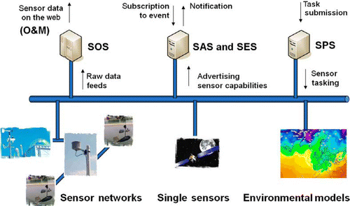
SWE provides a set of standards dedicated to the integration of time series data into classical SDI. It complements established OGC standards, such as Geography Mark-up Language (GML) (OGC Citation2007b) and the data access components Web Feature Service (WFS) (OGC Citation2005) and Web Coverage Service (WCS) (OGC Citation2008b). The Observations and Measurement (O&M) standard provides the underlying data format, which can be used to encode a series of in-situ measurements, such as air pollution; and remotely sensed information, such as satellite imagery (OGC Citation2007c). O&M is the standard for encoding sensor data on the web, where the SOS is the data access service exposing O&M (OGC Citation2007d). It is used to encapsulate raw data feeds from single sensors, sensor networks, sets of both and simulations. As an OGC service, it follows the common interface specifications (OGC Citation2006) and extends them with descriptions of available sensors and access to dynamic geospatial data. Initially the SOS was used to provide raw data, such as the results of a series of temperature measurements. In the last years, the SOS has been increasingly used to access value added products, i.e. processed observation results, such as daily averages of temperature, maxima of daily concentration of air pollutants or results of dispersion models (Havlik et al. Citation2009).
Apart from pure data provision, which implies pull-based communication, information can be pushed to potentially interested users via the Sensor Alert Service (SAS) (OGC Citation2007a). The SAS allows clients to subscribe to events. Clients specify conditions under which they would like to be notified using a simple constraint model. The SAS monitors inputs from advertised sensors. Notifications are triggered each time a certain constraint is met, when a specific pattern occurs, for example. Users may be interested in high spatio-temporal frequency of pollutant concentrations above a specific threshold or of a significant rise of temperature. As soon as the SAS identifies a defined pattern, it sends notification messages to all interested users. The SAS optionally supports the Common Alerting Protocol (CAP) of the Organization for the Advancement of Structured Information Standards (OASIS Citation2005). Currently, the SAS is being generalised towards a Sensor Event Service (SES), which basically provides a richer constraint model, i.e. it allows for more complex patterns (OGC Citation2008a).
If in any case sensors or other processes should be tasked, for example, if a new measurement series should be initiated, the Sensor-Planning Service (SPS) can be used for calibration (OGC Citation2007e). In addition to the common OGC web service capabilities, the SPS provides sensor descriptions including information on how sensors, sensor networks and simulations may be tasked. For example, a sensor network can be set up to measure air pollution in intervals of 5 minutes or a satellite can be tasked to sense a specific region on the surface of the globe.
At the moment all SWE standards are under internal revision at OGC. Version 2.0 of SWE is planned for this year (2010). In addition, O&M will become an ISO standard.
4.2. Mapping between VGI sensing and SWE standards
Any kind of spatio-temporally referenced resource, for example, geo-tagged and time-stamped photographs posted on picture-sharing platforms, can be encoded in O&M. Such encoding can easily include additional attributes, such as a list of (thematic) keywords. In this way, every piece of VGI could be encoded as an observation or measurement using the existing OGC standard. We argued earlier that this most obvious use of the O&M standard means providing stimuli as observation results (Section 4.1). However, due to the low level of information provided and to the sheer amount of data, we favour the use of O&M encoding at the sensation and perception level of DENS (Chapter 3). In particular, O&M offers ComplexObservation as a construct to represent n-dimensional values of heterogeneous types and ObservationCollection as a means to represent sets of observations (OGC Citation2007c). With these capabilities, O&M can be directly encoding collections of VGI items collected under pre-defined constraints. For example, such collections can be a set of geo-tagged photographs and related information (such as time stamps) retrieved from a picture-sharing platform. Spatio-temporal clusters of such information can be encoded in a similar manner.
Classically, the SOS is used to encapsulate single sensors, sensor networks, sets of both and simulations. In principle, any other provider of O&M encoded data could be encapsulated in a similar way. This includes pieces of VGI (each user is considered a sensor), complete platforms (considered as a sensor network) and value added information, such as organised streams or spatio-temporal clusters of VGI. The first two closely correspond to a SOS offering raw data, while the latter provides another instance of a SOS providing access to value added products. We thus argue that expressing the VGI activity in O&M and providing it as a SOS implements parts of the perception step for VGI sensing in DENS.
The SAS allows clients to subscribe to alerts. Notifications are triggered if a certain constraint is met. This principle can directly be applied to perceptions and attention in the VGI sensing context. For example, if spatio-temporal clusters of VGI items related to a specific hazard are identified and exposed by a SOS (perception), and if the SAS identifies that the size of a cluster (expressed in number of VGI items or other metrics assessing its relevance) reaches a certain threshold (still perception), then a ‘hot spot’ is detected and the SAS sends an alert to responsible authorities (attention). The SES, which basically provides a richer constraint model, than the SAS, provides the frame for including complex patters of VGI.
Accordingly, can be extended in order to account for VGI as SOS ().
Figure 2. SWE for VGI sensing (capabilities listed in remain).
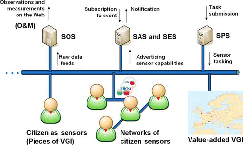
Finally, the SPS can be used for the calibration of value-added VGI products. In a given VGI setting, such SPS calibration may be applied to clustering algorithms that identify hot spots. For example, the threshold for triggering alerts can be tuned using socio-economic indicators. For instance, densely populated zones with great internet connectivity will most likely generate more VGI than others, where relevant events may be reported by less abundant VGI. The importance of this calibration issue needs to be underlined. Unlike observations based on purely mechanical sensors (e.g. in satellite remote sensing), VGI sensing relies on human factors. Therefore, particular care must be taken during the calibration process, where cultural and technical constraints that lead to the creation of a VGI item can be modelled in order to measure the statistical significance of the derived information. If DENS identifies a lack of information, an SPS may also be used to task additional senses, for example, a satellite could be tasked (as already described in Section 2.3), thus mobilising complementary senses to investigate further the problem.
provides a mapping of the notions of SWE and our more general concepts underlying the nervous system. The VGI examples on the right of the table are an extract of our previous examples (Section 3).
Table 2. Mapping between general concepts of the nervous system and SWE for VGI sensing.
5. A forest fire scenario
In this section, we provide a DENS implementation scenario involving an information system related to forest fires, a type of crisis of particular importance in the European context. We start with describing the current system, which is mostly based on remote sensing. Then we describe how VGI sensing can be integrated in such systems. Finally, we explain how such an example illustrates opportunities and constraints of remote sensing, VGI sensing and SDI integration.
5.1. Forest fire hot spot detection by remote sensing
The European Forest Fire Information System (EFFIS) of the European Commission provides support to forest fire fighting and prevention in Europe throughout the fire season (San-Miguel-Ayanz et al. Citation2002). Every year an average of over 500,000 hectares of forests are burned by wildfires throughout Europe. The impact of these fires is significant both financially and in terms of human lives. The EFFIS system was developed to provide continuously updated forest fire-related geospatial information during crisis situations to enhance international cooperation (e.g. by aerial fire fighting) and support decision making.
The EFFIS web portal (http://www.effis.jrc.ec.europa.eu/) provides this fire information through a comprehensive but simple interface. Critical information is displayed over a web map and rapid access to datasets and map services are provided using SDI standards. These include two major added-value information products of EFFIS: the hotspots layer (for active fires detection) and burned areas layer (for monitoring forest fires events).
Active fires are located on the basis of the hotspots product of MODIS sensors on board of TERRA and ACQUA satellites (Kaufman et al. Citation1998), which identifies areas on the ground that are distinctly hotter than their surroundings. The difference in temperature between the areas that are actively burning with respect to neighbour areas allows the identification and mapping of active fires. In addition, detected hot spots are overlaid with land cover information to retain only those taking place in forest areas. The mapping of active fires is performed to provide a synoptic view of current fires in Europe and as a mean to help the subsequent mapping of fire perimeters. Information on active fires is normally updated daily and made available in EFFIS within 3–4 hours from MODIS acquisition.
Forest fires events are monitored by mapping dynamically burnt areas and characterising fire events using several information sources. Firstly, the active fires map described above is used to locate areas requiring further analysis. Secondly, satellite images are used to delimit the burnt area perimeter. Thirdly, burnt areas are overlaid with a series of reference data to characterise the risks related to each fire event. Reference data include protected areas, population density, sensitive infrastructures and local meteorological conditions. In addition, EFFIS includes a systematic collection of fire news from European media sources (using multilingual RSS feeds filtering and aggregation techniques), which completes with the overview of the fire's importance within short time delays. As a consequence of this processing chain, a list dynamic of forest fires with major importance is created.
Active fire detection and burnt areas mapping activities are feeding a dedicated application created by the EFFIS team with the purpose of providing geospatial information support to the European Commission's Monitoring and Information Centre (MIC) on current major fire events in Europe and the Mediterranean area. Since 2009, the MIC has been in charge of tasking the European Forest Fire Tactical Reserve (EUFFTR). This fleet is composed of two Canadair CL 215 fire fighting aircrafts stationed in Corsica. In the event of major forest fires and under request of a given country, the EUFFTR is deployed to support fire fighting operations. If multiple concurrent major fires occur in different parts of Europe and two or more countries request EUFFTR assistance, the MIC has to evaluate risk and potential population affected to determine tasking priority. To aid this decision-making EFFIS provided and maintains an easy-to-use feature rich web application, which combines information from a number of sources.
5.2. Forest fire hot spot detection by VGI sensing
In this section, we describe how the current system can benefit in the future of VGI integration, thus becoming a VGI-enabled EFFIS. As shown in the description above, EFFIS operates on remote sensing information and reference SDI databases to provide situation awareness about major forest fires in Europe and support decisions for tasking aerial fire-fighting capabilities. The current version of EFFIS does already have information available through the web, by completing fire-related assessment through consultation of online news.
In this context, VGI can be seen as a rich and complementary source of information for the purpose of identifying active fires. As described in Section 4.2, we propose to use SWE for VGI to provide EFFIS with a dynamic and organised stream of VGI describing forest fire events. In other words, we suggest the creation of VGI-sensed hot spots to complement the hot spots obtained through remote sensing. In practice, this can be done by triggering an automatic alert when the threshold has been reached in the size of VGI clusters related to forest fires.
In addition to its potential contribution to active fires detection, VGI can be used to further document and characterise detected fire events, thus supporting the second major EFFIS dataset: burnt areas mapping. In this perspective, VGI can be seen as a powerful complement to traditional geographic information layers and to the News aggregation system already in place. Twitter feeds, citizens’ contributed photos, personal blog articles, etc. would allow for an even richer picture of the fire situation which includes in a single view modelled fire risk, space observed data and ground reported information. This could be of particular interest when fires are threatening populated zones, where VGI can be used to depict a situation that local population is faced with.
This example shows how VGI sensing can be used to support activities related to forest fires detection and characterisation, thus acting as an additional sense of DENS to enhance perception of a particular type of crisis event. In the following section, we identify opportunities and constraints for a VGI-enabled EFFIS, thus providing directions for other possible DENS implementation scenarios.
5.3. Opportunities and constraints for a VGI-enabled EFFIS
While describing a VGI-enabled EFFIS, we illustrated how remote sensing, VGI sensing and SDI components can act as complementary senses supporting a crisis-related scenario. (To be noted, our example did not include use of in-situ sensors such as air quality or weather monitoring stations, which embody another important possible sense for DENS.) By proposing an integrated view of the situation based on these DENS senses to support decision making, the proposed solution addresses an essential requirement of crisis-related information systems, i.e. to ‘make sense of a very dynamic stream of information’ (De Groeve et al. Citation2010).
In EFFIS, added value is created on top of sensory information by using reference data bases, e.g. to check if a detected hot spot is situated in a forest area or to assess the potential impact of a detected forest fire. SDIs typically provide access to stable, trustable data source that can be used as in-memory knowledge in the processes of perception. In addition, the distributed, decentralised nature of SDIs allows gathering information that can have a certain level of dynamicity even if not collected through sensors (e.g. state of impacted infrastructures provided through a regional SDI), thus providing useful mechanisms to unlock information under responsibility of public authorities (Annoni et al. Citation2010).
As we noted above, EFFIS provides data visualisation as web services following SDI standards. We suggested further use of SDI standards, such as SOS for exposed added-value products as O&Ms, and SAS, to trigger alerts to subscribed clients. Such standards adoption will create wide opportunities for other crisis information systems to inter-operate with EFFIS, thus implementing the next generation DE vision as a ‘multiple connected infrastructures based on open access and participation across multiple technological platforms’ (Craglia et al. Citation2008).
However, while standards compliance and provision of web services guarantees openness, information in a sensitive field such as crisis management should be distributed carefully. A trade-off must be found between openness and reactivity from one side, and security and confidentiality from the other side.
Another constraint for standards adoption relies on their evolving nature, as co-existence of various versions of similar standards can result in lesser interoperability of systems. This risk exists, for example, for SWE standards, as a new version (SWE 2.0) is still underway.
6. Conclusions and future works
In this paper we proposed the DENS as a new metaphor to extend the DE vision and to provide more dynamic capabilities that fulfil specific requirements of crisis management information systems. In complement to in-situ sensor devices and remote sensing platforms, we identified SWE of VGI as an essential step towards the implementation of a DENS. Indeed, SWE provides a framework for integration of VGI in expert-driven systems in a timely way, providing a good synthesis of the situation to decision makers, while complying with a reasonable level of quality-control that is expected in this context.
We coined the term VGI sensing to designate the set of standards, methods and techniques required to streamline geo-referenced contents published online by citizens as a new sense for the DENS. Future works are required in this novel research field. Firstly, specific techniques should be developed to crawl, retrieve, filter and coherently organise heterogeneous VGI data from the web, in order to capture a digital image of stimuli provided by citizens. Secondly, advanced pattern recognition and knowledge discovery methods are required to automatically interpret and characterise events from VGI, taking into account the specific semantics of such user-generated information. Thirdly, VGI sensing should include calibration methods to improve quality assessment and ranking of aggregated items, while considering socio-economic, sociological and cultural factors that shape event-related VGI creation and publication.
By introducing DENS we suggest to move from DE as a ‘multi-resolution, three-dimensional representation of the planet’ to an active and dynamic multi-dimensional framework able to monitor changes, react to crisis and improve citizens’ ability to contribute to situation awareness and decision making.
Notes on contributors
Bertrand De Longueville is a Scientific Officer at the European Commission's Joint Research Centre (JRC). He contributes to the implementation and evolution of Environmental Information Systems with focus on innovative geospatial web services, distributed architectures and collaborative processes. In particular, his research activities deal with the integration of non-expert users’ knowledge in the next generation environmental information systems. He holds an M.Sc. degree in Environmental Engineering from the Louvain-la-Neuve University (Belgium) in collaboration with which he is currently completing a Ph.D. degree in Environmental Engineering Sciences.
Alessandro Annoni graduated in Physics from the University of Milan, Italy. He worked in the private sector from 1979 to 1996 managing companies specialising in advanced studies in Geoinformation and Earth observation, and in GIS software development. He has been working at the European Commission's Joint Research Centre (JRC) in the Institute for Environment and Sustainability, since 1997. He is currently the Head of the Spatial Data Infrastructures (SDI) Unit that includes a technical team of about 40 scientists working on SDIs, the largest group in Europe in this field.
Alessandro has 30 years working experience in various fields (forestry, agriculture, oceanology, hydrology, nature protection and conservation) dealing with spatial planning, spatial analysis, environmental modelling, Geoinformation and related technologies (GIS), remote sensing, image processing, system design and software development. He has been the Technical Coordinator of the INSPIRE initiative (Infrastructure for Spatial Information in Europe), since 2001. In 2006 he has been appointed as co-chair of the Architecture and Data Committee of the Group on Earth Observations (GEO). He is a member of the Executive Committee of the International Society for Digital Earth (ISDE).
Sven Schade holds a Diploma and Ph.D. degree in Geoinformatics; both from the University of Muenster, Germany. He worked at the Institute for Geoinformatics for more than 7 years, where he was involved in teaching and in numerous national and European research projects relating to Spatial Data Infrastructures (SDI), and Semantic web technology. In October 2009, he became postdoc at the SDI group of the Joint Research Centre (JRC) of the European Commission. His research is focusing on the translation of geospatial data and interoperable service architectures. He specifically addresses the use of linked data in the sensor web and possible contributions to the Digital Earth vision. So far, he has published more than 40 scientific articles on the above mentioned areas.
Nicole Ostlaender holds an M.Sc. degree in Landscape Ecology and recently completed her Ph.D. degree in Geoinformatics from the University of Muenster, Germany. Her research interests include Spatial Data Infrastructures (SDIs) and distributed geo-processing, Volunteered Geographic Information and Environmental Information Systems. She is currently working at the Spatial Data Infrastructures Unit of the European Commission's Joint Research Centre in Ispra, Italy, where she is involved in the implementation of the INSPIRE Directive and the design and implementation of SDI-based Environmental Information Systems.
Ceri Whitmore holds an M.Sc. degree in Computer Science from the University of Bristol, UK (2005–2006), and has spent a number of years specialising in developing GIS applications by using various technologies. He is currently working for the ‘Forest’ action of the European Union Joint Research Centre, creating web-based GIS applications. His work principally focuses on the EFFIS Current Situation map viewer, displaying up-to-date critical fire-related information, through a user-friendly interface. He continues to conduct research into solutions for complementing and enhancing information provided to the end-user.
Acknowledgements
The authors would like to thank Dr. Robin S. Smith for his helpful comments on drafts of this paper. We would also like to particularly thank Ms. Cécile Misonne (Neuro-psychologist) for supporting our understanding of the human sensory system and guiding us to appropriate references in this field.
References
- Annoni , A. , Craglia , M. , de Roo , A. and San-Miguel , J. 2010 . “ Earth Observations and Dynamic Mapping: key assets for risk management ” . In Geographic information and cartography fore risk and crisis management. [Lecture Notes in Geoinformation and Cartography] , Edited by: Konecny , M. , Zlatanova , S. and Bandrova , T. 3 – 22 . Berlin, Heidelberg : Springer-Verlag .
- Attneave , F. 1959 . Applications of information theory to psychology: a summary of basic concepts, methods, and results , New York : Holt, Rinehart, and Winston .
- Bahree M. 2008 Citizen voices Forbes Magazine Available from: http://www.forbes.com/free_forbes/2008/1208/083.html [Accessed 10 December 2009]
- Bishr , M. and Mantelas , L. 2008 . A trust and reputation model for filtering and classifying knowledge about urban growth . GeoJournal , 72 ( 3–4 ) : 229 – 237 .
- Botts , M. , Percivall , G. , Reed , C. and Davidson , J. 2008 . OGC Sensor Web Enablement: overview and high level architecture . Lecture Notes in Computer Science , 4540 : 175 – 190 .
- Budhathoki , N.R. , Bruce , B. and Nedovic-Budic , Z. 2008 . Reconceptualizing the role of the user of spatial data infrastructure . GeoJournal , 72 : 149 – 160 .
- Butler , D. 2006 . Virtual globes: the web-wide world . Nature , 439 : 776 – 778 .
- Craglia , M. 2008 . Next-generation Digital Earth: a position paper from the Vespucci Initiative for the advancement of geographic information science . International Journal of Spatial Data Infrastructures Research , 3 : 146 – 167 .
- Damasio , A.R. and Sutherland , S. 1996 . Descartes’ error: emotion, reason, and the human brain , London : Papermac .
- De Groeve T. et al. 2010 Mash-up or SDI: appropriate mapping tools for emergency situation rooms P. Boccardo Proceedings, of the 2000 geomatics for disaster management conference Torino, , Italy G4DM 122 130
- De Longueville B. Smith R.S. Luraschi G. 2009 “OMG, from here, I can see the flames!”: a use case of mining location based social networks to acquire spatio-temporal data on forest fires X. Zhou X. Xie Proceedings of the 2009 international workshop on location based social networks Seattle, WA ACM 73 80
- De Longueville B. et al. 2010 Citizens as sensors for natural hazards: a VGI integration workflow Geomatica Special issue on VGI 64 (1) (in press)
- De Rubeis V. Sbarra P. Tosi P. 2009 Web based macroseismic survey: fast information exchange and elaboration of seismic intensity effects in Italy J. Landgren S. Jul Proceeding of the 6th International ISCRAM conference. Gothenburg, Sweden Available from: http://www.iscram.org/ISCRAM2009/papers/ [Accessed 8 April 2010].
- Elwood , S. 2008 . Volunteered Geographic Information: key questions, concepts and methods to guide emerging research and practice . GeoJournal , 72 ( 3–4 ) : 133 – 135 .
- Flanagin , A.J. and Metzger , M.J. 2008 . The credibility of Volunteered Geographic Information . GeoJournal , 72 : 137 – 148 .
- Goodchild , M. J. 2007 . Citizens as sensors: the world of volunteered geography . GeoJournal , 69 ( 4 ) : 211 – 221 .
- Gore A. 1998 The Digital Earth: understanding our planet in the 21st century Available from: http://www.isde5.org/al_gore_speech.htm [Accessed 8 April 2010].
- Grossner , K. , Goodchild , M. and Clarke , K. 2008 . Defining a digital earth system . Transactions in GIS , 12 ( 1 ) : 145 – 160 .
- GSDI 2004 Developing Spatial Data Infrastructures: the SDI cookbook D. D. Nebert Available from: http://www.gsdi.org/docs2004/Cookbook/cookbookV2.0.pdf [Accessed 25 February 2010]
- Harnad , S. 1987 . “ Psychophysical and cognitive aspects of categorical perception: a critical overview ” . In Categorical perception: the groundwork of cognition , Edited by: Harnad , S. 1 – 25 . New York : Cambridge University Press .
- Havlik , D. , Bleier , T. and Schimak , G. 2009 . Sharing sensor data with sensor SA and cascading sensor observation service . Sensors , 9 ( 7 ) : 5493 – 5502 .
- Hughes A.L. Palen L. 2009 Twitter adoption and use in mass convergence and emergency events J. Landgren B. Van de Walle Proceeding of the 6th international ISCRAM conference. Gothenburg, Sweden Available from: http://www.iscram.org/ISCRAM2009/papers/ [Accessed 8 April 2010]
- Jirka S. Broering A. Stasch C. 2009 Applying OGC Sensor Web Enablement to risk monitoring and disaster management Proceeding of the 11th GSDI world conference. Rotterdam, The Netherlands Available from: http://www.gsdi.org/gsdiconf/gsdi11/prog-details.htm [Accessed 8 April 2010]
- Kaufman , Y.J. 1998 . Potential global fire monitoring from EOS-MODIS . Journal of Geophysical Research D: Atmospheres , 103 ( D24 ) : 32215 – 32238 .
- Lee V. 1994 Volunteer monitoring: a brief history The Volunteer Monitor 6 1 29 32
- Mummidi , L. and Krumm , J. 2008 . Discovering points of interest from users’ map annotations . GeoJournal , 72 ( 3–4 ) : 215 – 227 .
- Newell , A. and Simon , H.A. 1972 . Human problem solving , Englewood Cliffs, NJ : Prentice-Hall .
- OASIS 2005 OASIS Common Alerting Protocol (CAP) – version 1.1
- OGC 2005 OGC WFS Implementation Standard 1.1.0
- OGC 2006 OGC OpenGIS Web Service Common Implementation Specification – version 1.1.0
- OGC 2007a OGC Sensor Alert Service – version 0.9
- OGC 2007b OGC GML Implementation Standard 3.2.1
- OGC 2007c OGC Observations and Measurements – version 1.0
- OGC 2007d OGC OpenGIS Sensor Observation Service – version 1.0.0
- OGC 2007e OGC Sensor Planning Service (SPS) – version 1.0.0
- OGC 2008a OGC Sensor Event Service Interface Specification – version 0.3.0
- OGC 2008b OGC Web Coverage Service (WCS) Implementation Standard – version 1.1.2
- O'Reilly T. 2005 What is web 2.0 design patterns and business models for the next generation of software Available from: http://www.oreillynet.com/pub/a/oreilly/tim/news/2005/09/30/what-is-web-20.html [Accessed 8 April 2010]
- Palen L. Vieweg S. Liu S.B. Hughes A.L. 2009 Crisis in a networked world: features of computer-mediated communication in the April 16, 2007, Virginia Tech event Social Science Computer Review 27 4 467 480
- Port R.F. Van Gelder T. 1995 Mind as motion: explorations in the dynamics of cognition Cambridge, MA The MIT Press
- Ross J. 2009 The rise of the social nervous system Forbes (March 2009). Available from: http://www.forbes.com/2009/03/09/internet-innovations-hive-technology-breakthroughs-innovations.html?feed=rss_technology [Accessed 8 April 2010].
- San-Miguel-Ayanz J. et al. 2002 Towards a coherent forest fire information system in Europe: the European Forest Fire Information System (EFFIS) X. Viegas Forest fire research & wildland fire safety Rotterdam Millpress 45 64