Abstract
Simple navigation receivers can be used for positioning with sub-centimeter accuracy in a wireless sensor network if the read-out of the carrier phase (CP) data is possible and all data are permanently broadcast to a central processing computer. At this base station an automated near real-time processing takes place and a precise differential GNSS-based positioning of the involved sensor nodes is computed. The paper describes the technical principles of such a system with its essential demands for the sensing, the communication, and the computing components. First experiences in a research project related to landslide monitoring are depicted. Of course the developed system can also be embedded for location finding in a widespread multifunctional geo sensor network. The quality of the obtained result is restricted due to the fact that the CP measurements must be recorded over a certain time span, usually a few minutes for every independent position solution. As far as possible a modular structure with commercial off-the-shelf components, e.g. standard wireless local area network for communication, and in cooperation of existing proofed and powerful program tools is chosen. Open interfaces are used as far as possible.
1. Introduction
Geodetic monitoring of building structures and parts of the earth, e.g. crustal movements, glaciers and landslides, based on satellite positioning is well-known and proven for many years. High-precision and therefore normally cost-intensive measuring technology is generally used. The resultant consequence is a limitation of the number of monitored objects, only a few selected object points and – if performed manually – the restricted number of conducted monitoring periods. Thus, a cost-effective continuous supervision can often not be realized using the available products. Most endangered objects like landslides, etc. require a permanent, wide-ranging surveillance with a huge diversity of sensors to gain a deep appreciation of ranges and the courses of movements. Causal mechanisms can only be deflected on high-qualitative and reliable base data – a trustworthy prediction of feasible critical situations could be possible if any only then. Because of slow motion processes with movement rates of a few millimeters up to centimeters or sometimes decimeters per year in nearly all these applications high demands on the precision of the monitoring measurements are always made.
Regarding landslides in particular, global climate change, the rise of endangered areas due to tourism and new infrastructure projects and especially an increased sensitivity of the population to natural hazards show the need for supplying cost-effective techniques to set up monitoring systems also in regions where normally an implementation could not be realized for financial reasons. The assembling of such systems is accompanied – and stimulated – by the ongoing pervasive impact of wireless, respectively, geo sensor networks (GSNs) in all geo sciences.
The paper is focused on the general description of a low-cost phase-based differential global navigation satellite system (GNSS) approach to make use of simple navigation receivers for positioning in the sub-centimeter range. The configuration of a GSN is depicted by the example of a monitored landslide in the Bavarian Alps. Some results will be presented to demonstrate the capability of the developed approach.
2. Sensor networks for monitoring tasks
To get a focus all following explanations are made with regard to geodetic and geotechnical applications whereas landslide monitoring is one main subject.
2.1. Wireless sensor networks (WSNs)
Collecting data at a central location from diverse scattered geodetic and geotechnical sensors in the context of surveillance tasks need well structured and standardized methods of data transmission. Bridging efficiently huge distances (of several kilometers) from the different sensing units to the central data sink in the field mainly wireless transmission techniques come into consideration. Such a wireless network infrastructure in combination with linked sensors is a wireless sensor network (WSN) and consists according to Sohraby et al. (Citation2007) of the following basic components:
-
An assembly of distributed or localized sensors.
-
An interconnecting network (usually wireless-based).
-
A central point of information clustering (central data sink, base station).
-
A set of computing resources at the central point and/or beyond to handle data analysis, event trending, status querying, maintenance, etc.
In which hierarchy individual network properties, the so called sensor nodes communicate with each other in a WSN is not especially ascertained. The fundamental methods are star-based (point-to-point), mesh-based with multi hop radio connectivity or a combination of both. These available techniques are already developed for mass markets. According to this circumstance the hardware components can be obtained with good prices, however. A WSN is generally characterized by a large number of low-cost, low-power, multifunctional wireless devices – the mentioned sensor nodes or motes – deployed over a geographical area in an ad hoc fashion and without careful planning (e.g. Bill Citation2008). Especially features like minimized size, minimized power consumption, and low costs of the sensor nodes are stated as typical. But there is no universal WSN with all these across-the-board mentioned features at the same time. It depends on the application which specifications with respect to capability, data quality, size and costs, etc. of the sensor nodes and the requirements at the communication component (data throughput) are relevant. At outdoor applications the criterion for exclusion is the reachable data rate depending on the distances by wireless transmission. An overview of common wireless communication standards is given in.
Table 1. Common wireless communication standards (Glabsch et al. 2009).
In summary the following characteristics of sensor nodes can be given (Günther et al. Citation2008, Glabsch et al. Citation2009):
-
A distinct addressability.
-
Mobile or immobile, whereas at moving sensor nodes (object points) the recurrent positioning is mandatory.
-
Working time or event-based, whereas the requirement to synchronization and as well to data quality depends on the dynamic of the investigated process.
-
Capacity of data buffering (temporary storage) and optionally data pre-processing in order to minimize the data for dispatching.
-
As an option ability of steering and acting (actuator or mobilizer).
-
Maybe the (single) task of gathering and remit data, often also called repeater or relay stations.
A wireless local area network (WLAN) is the most suitable and efficient way to build up a network infrastructure in a geodetic or geotechnical survey at the moment. Compared directly to conventional radio data transmission WLAN features the following key benefits (Pink Citation2007):
-
More cost-effective acquisition.
-
Easier addressability of the sensor nodes.
-
Minor power consumption in autarkic usage.
-
Subject to authorization not necessary.
-
Possibilities of encryption.
-
A suitable high transfer rate which is a precondition using the low-cost precise differential GNSS (LC PDGNSS) approach.
Using hardware components of the actual IEEE 802.11g standard, data rates of up to 54 Mbps are possible by reaching distances over several kilometers. In future 300 Mbps will be possible with the new IEEE 802.11n standard.
2.2. Geo sensor networks (GSNs)
A GSN maybe loosely defined as a sensor network that monitors phenomena in a geographic space. They are derivates of WSN without an own separated theory. The main tasks of GSN are:
-
Guidance and control, e.g. fleet management systems.
-
Network centric warfare.
-
Monitoring applications, especially early warning systems and catastrophe management.
Because of the nature of GSN, the positioning component plays an essential role. Further differences to a WSN are in general that the sensor nodes in a GSN normally are systematically adapted at the object being sure to gather all parameters, especially movements, at its best. Usually this cannot be achieved in short observation periods, hence a permanent operation and autarkic power supply of the sensor nodes must be assured over longer times – often year-round operability. Sensors like extensometers or inclinometers mainly are used for the detection of relative movements. For the determination of exact absolute 3D positions and their changes a positioning method with respect to a reference frame is needed. Here, total stations or the use of a GNSS is possible and proven. This paper only concentrates on the last mentioned method which is explained in detail in the following.
2.3. Positioning component using global navigation satellite system (GNSS)
Confronted with satellite-based positioning and navigation most people think first of all of the well-known US global positioning system (GPS). Simple receivers are widely used in car navigation systems and recently even mobile phones are equipped with integrated receiver chips. The so called standard position service (SPS) is defined by using pseudo ranges resulting from the L1 C/A-code measurements to at least four satellites. The achievable accuracies of such an autonomous positioning is in the range of approximately 3–5 m in horizontal component, see e.g. SPS PS (Citation2008). Better results can be achieved using high sophisticated differential methods, generally called DGPS (Differential GPS). An impression of reachable accuracies of SPS and code-based DGPS is depicted in . In a case study two different low-cost receivers were tested under quite ideal conditions (few shadowing effects, many satellites in view). The variations to be seen correspond to true values obtained with high-quality geodetic GNSS equipment.
Figure 1. Typical results for code-based autonomous positioning SPS (green, µBlox LEA-4T) and code-based differential positioning DGPS (blue, Novatel Smart Antenna V1G). For technical specifications of the receivers LEA-4T and V1G see . Depicted are the variations with respect to true values over a period of almost half an hour. Recording frequency was 1 Hz.
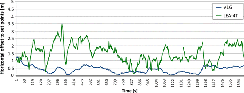
The overall SPS accuracy of horizontal coordinates (2σ, 95% level) in several experiments of the test device LEA-4T was 3.9 m and of the test unit Smart Antenna V1G less than 1.0 m in code-based DGPS mode. Both results clearly show that the achievable accuracies are not sufficient at all to meet geodetic claims of centimeters or a few millimeters demanded in monitoring applications. Normally more cost-intensive receivers supporting carrier phase (CP) measurements have to be employed. The two geodetic standard positioning methods in this case are real-time kinematic (RTK) and post-processing (PP) with accuracies of 2–3 cm using RTK, respectively, 2–3 mm using the PP approach (static set up with data acquisition over a certain time). Both methods are based on baseline calculations between the involved receivers; at least two receivers are needed for a phase-based precise differential positioning (PDGNSS). Using PDGNSS techniques to observe discrete points permanently in a monitoring network the results should be available as soon as possible. Hence, the ideal concept would be a combination of RTK (‘real time’) and PP (‘high accuracy’). However, a relatively short latency has to be accepted to gain high accuracies using furthermore simple receivers as they are already shown in .
The GNSS–near real-time processing (NRTP) approach is very close to this association. It bases on the evaluation of CP measurements recorded over certain, in principle freely and individually selectable time span, in the following mentioned as an epoch. Depending on the receivers and the satellite visibility usually a time interval of 15 min with a recording frequency of 1 Hz is considered for the CP raw data acquisition. Independent position solutions are obtained for every epoch and it is assumed that the dynamic of the investigated process does not collide with such an acquisition period. Once the raw data from the several sensor nodes – at least one on stable ground, that serves as a reference station and diverse other object points on the slope – are available at a central computing station the baseline processing can start. The concept of automated raw data recording and transferring from all involved receivers (respectively, sensor nodes) and the contemporary attached baseline processing is called NRTP.
The development of a widespread usable, cost-effective and at the same time powerful GNSS monitoring system is the main focus at the Institute of Geodesy, UniBw Munich. Several simple low-cost L1 receivers are investigated at present. Main prerequisite of these receivers is that they must have the possibility to read-out the CP data. Most of the simple navigation receivers make use of these data for internal smoothing operations but do not have the ability of an autonomous phase-based positioning. Using such receivers, costs can be reduced considerably in comparison with geodetic two frequency receiver like for instance a Leica GNSS 1200.
Finally, the NRTP concept opens all the well-known options of high sophisticated PP to all kind of simple receivers with a possibility of read-out the CP data in a geodetic monitoring network. Looking at the recent developments mentioned above and regarding the necessity of a communication component for the permanent data broadcast the whole approach might be addressed as GSN. In the majority of cases, the precise location finding component is embedded in a multifunctional approach. In addition to the length of an epoch, a delay of some minutes processing time to gather all data at the base station and to conduct the processing has to be accepted applying the NRTP concept. With the expected movement rates and necessary advance warning times for a sliding slope, this understanding of ‘near real time’ represents no restriction to the intended use for early warning. At other applications this maybe is to discuss more differentiated.
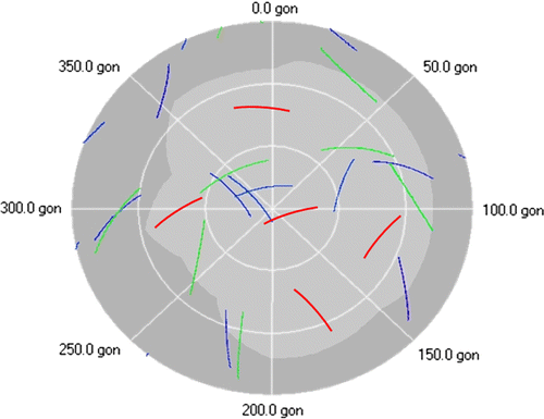
Using – and mixing – the terms GPS and GNSS above should be explained in brief. Further systems beside the US GPS are – at least – the Russian GLONASS (GLObalnaja NAwigazionnaja Sputnikowaja Sistema) and, hopefully, in future the European GALILEO. Depending on the receiver a great effort consists of a combination of the available systems which will lead to increased accuracies and better operational availability in positioning, especially based on a coincidental tracking of more satellites in view. By the example of a landslide area in the Bavarian Alps with heavy shadowing effects this benefit is depicted in . Using the GPS only there are temporary phases where no reasonable solution can be obtained during a day. With the increased number of satellites a much better coverage is given and a reliable GNSS-based positioning will be possible permanently even under such restricted conditions.
Figure 2. Sky plot for an exemplary period of 1 hour in 2009 at the Bavarian Alps with a typical shadowing situation. In blue the GPS SVs are depicted, in green the Glonass and in red future Galileo satellites.
2.4. Basic considerations
There is a tremendous number of already developed GNSS-based monitoring systems for geodetic and geotechnical engineering today, for example described (and developed) by Bäumker and Fitzen (Citation1998), Hudnut and Behr (Citation1998), and Hartinger (Citation2001). These other approaches are proofed in practical applications and shall not be discussed here. The main benefit of the GNSS–NRTP approach of UniBw is the design as a GSN with low-cost sensors and open interfaces for a widespread use of the results.
When starting with the development of a GSN for monitoring tasks the following basic considerations were made (Pink Citation2007):
-
Possible and easy integration of all standard geodetic and geotechnical instruments via serial interfaces, which are factory-made commonly available at standard instruments.
-
Main attention to the application of low-cost GNSS sensors.
-
Possibility of wire-line and especially wireless standard communication techniques, whereas WLAN offers the best perspectives at the moment.
-
Applicability of all built-in devices for rough environmental conditions (year-round operation, mountain climate).
-
Strict separation between data recording and essential evaluation steps using as far as possible existing and proven program packages with defined (open) interfaces.
As far as possible commercial off the shelf hardware and software products are utilized.
3. Example of GSN Aggenalm landslide
By the example of the Aggenalm landslide the NRTP approach will be discussed in practical realization. The approach is embedded in the development of a cost-effective GSN for landslide monitoring, a recent joint research project at the UniBw Munich. For more details on the project please see Thuro et al. (Citation2009) and refer to http://www.alpewas.de
3.1. Configuration GSN Aggenalm landslide
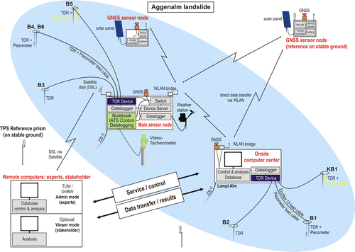
The GSN Aggenalm landslide is a multifunctional sensor network for research purposes as to be seen schematically in . The three different measurement components are: a pillar mounted video assisted total station for contactless scanning of the surface (boulders, etc.); several boreholes supplied with automated time domain reflectometry devices (TDR) for the detection of bending in the bedrock, piezometers and a metrological station. The determination of the correct depth of installation is based on a comprehensive geological study of the slope and the obtained information during the drilling operations. The installation of the piezometers is slightly below the assumed shear zone at a depth from 15 to 30 m. The TDR cables were installed up to 10 m deeper. Furthermore, a low-cost PDGNSS component consisting of four nodes is included. The GNSS sensors are installed at locations of particular geological interest while one point is on stable ground. All sensor nodes can be read-out at two central points which are connected to the base station. The whole data traffic is handled in a WLAN supplemented by some wire-line connections for economical and practical reasons. A central computer is managing all system operations, e.g. data collection and logging and controlling of the sensor nodes. Additionally two inclinometers can be read-out manually from time to time to verify TDR. For remote maintenance and supervising a DSL internet connection via satellite is set up at the base station via a relay station at the so called main sensor node. Due to the use of a personal computer, the central station is attached to the local power network (220 V). At the Aggenalm landslide, although not mandatory, the main sensor node with a high diversity of different sensors and functionalities is also cable-connected to the local power network. All other sensor nodes have a battery-operated autarkic power supply (solar panel, charge controller, and battery). An additional fuel cell is installed at the GNSS reference sensor node, because during winter the solar radiation at this location is quite low.
Figure 3. Schematic configuration of the GSN Aggenalm landslide. Main intention is testing recently developed new measuring techniques under field conditions. The new measuring techniques are combined to a GSN with wire-line and wireless communication on site and a remote access via SkyDSL. The onsite computer center (base station) is located at an Alpine hut with 220 V power connection.
Again, only the LC PDGNSS component is discussed here in more detail. The slide is not appraised to be precarious which makes it ideal for research activities to prove new monitoring techniques under field conditions. Thus, early warning capability is more to be seen from a conception point of view.
3.2. GNSS hardware components
3.2.1. Receivers
Novatel Smart Antennas are selected as positioning sensors at the Aggenalm. This receiver type is an encapsulated system of board and antenna especially designed for harsh environmental conditions. Some primal specifications of this sensor are depicted in . Beside the code-based position the CP is recorded and can be read-out by the serial port. Depending on the satellite visibility such a 12-channel L1 receiver generates about 0.3 MB of binary data with a recording frequency of 1 Hz in an epoch of 15 min. To reduce costs of the sensor nodes furthermore, step-by-step alternative sensors like the LEA-4T or the Navistar GPS mouse are investigated. Specifications of these different GNSS sensor are arranged in .
Table 2. Specifications of selected GNSS sensor types.
3.2.2. Communication
The widespread and cost-effective deployment of a sensor network particularly needs to make use of commercial off-the-shelf wireless communication techniques and standardized protocols. An infrastructural WLAN is used for the connection of the sensor nodes in the field at the Aggenalm. All measuring devices are connected to wireless/wired device servers with two or more serial ports. Such a unit serves as serial to Ethernet converter and composes a decisive interface between every standard sensor and the network. In principle, any standard sensor with a serial interface can be embedded. To bridge distances of more than 500 m, special external antennas are used to provide adequate WLAN connectivity. Precondition for uplinks over such distances is the compliance of an (almost completely) obstacle-free first Fresnel zone (spheroid with the two antennas in the focal points). To check if an object interferes with this criterion of an adequate radio link, the radius of the Fresnel zone can be calculated according to Pink (2007).
r: Radius of the Fresnel zone (m); N: Number of the Fresnel zone; F: Value of the used frequency in MHz; d: Total distance of the radio link (m); d 1, d 2: Distances from obstacle to antenna (m)
Together with the wireless device server, a radiation power of 100 mW effective isotropic radiated power (EIRP) is not allowed to exceed due to statutory regulation. At the base station, a WLAN bridge forms the gateway between the wireless and the wire-line local area network, where the central computer is connected. The second bridge at the main sensor node at the Aggenalm acts as a relay station for the data from the other two GNSS sensor nodes and also serves as feed in point of the sensors at the bridge's station. For remote maintenance and data transfer to affiliated terminals (administrator, stakeholder, etc.) an internet link by DSL via satellite is set up.
3.2.3. Power management
Secure energy supply is of paramount importance for the sensor nodes, especially with regard to long-term monitoring without gaps and permanent year-round operability. The concept at Aggenalm provides solely solar panels together with back-up batteries. Additionally or alternatively the use of wind engines or fuel cells is an option. Based on the total power consumption at a single GNSS sensor node, a back-up battery with sufficient capacity is chosen to enable the system to work on for days without recharge. This time span of some days is called the autonomy factor. Mono crystalline solar panels are used for efficient recharge and charge controllers protect the batteries from total discharge or overcharge. Different data like the actual battery voltage, actual charge current, as well as the minimum and maximum values and the temperature can be read-out via the serial port of the charge controller, too. This metadata is also transmitted and potential failures caused by power shortfalls become predictable.
3.2.4. Computing resources
The data sink and processing unit at the base station is implemented by a customary personal computer. Demands for GNSS computing resources are small due to the fact of only four sensor nodes on site. With regard to a reliable and stable operation of the central control application and the data processing the computer should offer the possibility of extensions concerning additional interfaces such as serial ports and network interfaces. In order to attain secure data management the hardware should contain two hard disk drives. Permanent data mirroring allows a high level of storage reliability. An uninterrupted power supply (UPS) is absolutely necessary for a steady program running and highly recommended. Otherwise short time power blackouts or current fluctuations can lead to data loss and other severe system failures.
3.3. GNSS software components
The system's software consists of several different software packages. They are described briefly in the following.
3.3.1. Central control application
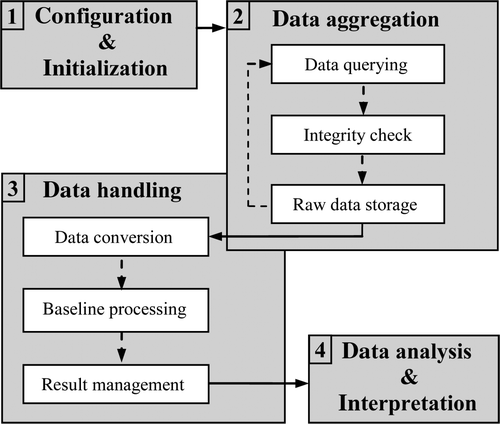
The central control application is the core of the software component. It is developed using the graphical programming language LabView®, National Instruments. All necessary steps from system initialization, data collection to the handover of processed and checked baselines for a subsequent time series analysis are actuated and supervised. A modular, prospective design offers the option to integrate a great diversity of GNSS sensors. Only the corresponding program implementation has to be realized. Interfaces permit an embedding of existing and proved software packages, especially for baseline processing with e.g. GrafNav, see Section 3.3.2. From every embedded software tool a command line-based control is the essential requirement. The work flow of the individual program segments and the data flow from the sensors to visualized results are depicted in . This work flow is briefly discussed in the following:
-
At first the GNSS monitoring system has to be configured and initialized. A configuration file – set up in advance by the administrator – has to be loaded. This data file contains the most important parameters of the monitoring system, e.g. number, type, and function of the used GNSS sensors, communication specific settings (IP-addresses, ports, data rates), storage paths, references, length of epoch, addressing, and specifications according to the different integrated external software packages. Corresponding to the settings in the configuration file, network communication is checked and all sensors are initialized. Thus designed individually, a high flexibility of the GeoSN-UniBw system arises. The configuration can be changed proportionate easily at any time.
-
In the next step data aggregation starts promptly after the initialization. This is an ongoing process where especially binary raw data from each GNSS sensor is queried step-by-step, checked for integrity (e.g. check sums) and stored in log-files. Reaching the preset time interval, the current log-file is closed and a new one created. Parallel to the ongoing process of data querying the step of data handling can start with the closed files. Conflicts of access rights are excluded this way.
-
Corresponding to the requirements of the GNSS baseline processing software tool (e.g. Waypoint GrafNav) the binary log-files are converted into a readable input file. Together with a specific parameter file (processing options) the baseline processing of these files will be executed. Subsequent to the computation a high sophisticated ‘result management’ takes place. After a first quality check, the corresponding input files for the final step of data analysis are created.
-
Finally, data analysis starts. The modular design offers the embedding of external software packages. In the context of the project alpEWAS, a separate software component is developed that on the one hand enables a single GNSS data analysis and on the other hand an integrative analysis where all data from the different measurement systems are evaluated in a combined analysis.
Figure 4. Work flow GeoSN-UniBw (Glabsch et al. 2009). The central control application comprises of four modular steps, external programs can be embedded.
Due to the fact, that all recorded raw data can be recalled at any time, a high flexible data analysis can be accomplished. A reprocessing of all raw data (baselines processing) with different adapted and optimized parameter settings (e.g. new length of intervals, satellite excluding) is possible at any time, if necessary. Finally, data storage is utilized by an open source MySQL database.
3.3.2. GNSS processing software
Waypoint GrafNav (Waypoint Citation2007) is used as commercial baseline processing software so far within GeoSN-UniBw. GrafNav is a manufacturer independent processing program which supports a graphical user interface and a command line call. After data gathering of each epoch the binary log-files are converted to the GrafNav specific GPB-format and the defined baselines are computed consecutively.
3.3.3. Time series analysis
Open interfaces offer possibilities of data exchange with other software packages for the final analysis of all data. For the Aggenalm, an own analysis tool based on LabView® is still under development for the time series analysis. Alternatively, a data exchange with the well-known software tool GPS online control and alarm (GOCA) can be performed (Glabsch et al. Citation2009). For details on the capabilities of GOCA see e.g. Jäger et al. (Citation2006) and Kälber and Jäger (Citation2001), especially diverse filters, estimators, and alarm functionalities are given.
3.3.4. Maintenance tools
To monitor the normal operation or to execute modifications at the central computer from a host workstation remote maintenance tools are required. With standard virtual network computing software (VNC) it is possible to present the desktop of a remote computer (server) on a local working platform (client). The complete communication is handled by the remote frame buffer protocol which allows a platform independent usage. To establish a successful connection the server's static IP address must be known. Available programs based on this approach are for instance Real VNC or Tridia VNC (no longer enhanced). In case of a not realizable static IP address – most telecommunication providers perform a forced disconnection every 24 hours or if the central computer is part of a network behind a router, where port forwarding is not operable – alternative software has to be chosen. Teamviewer, to give an example, uses an established internet connection to log on a main server allocated by the service provider. The whole communication and identification are based on an explicit user ID.
As experienced already, system breakdowns caused by power supply interruptions lead to displeasing data loss. Detecting such errors and managing them immediately require the use of special hardware- and software-based monitoring tools, for example so called ‘USB-Watchdogs.’
3.4. Some results
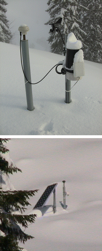
The GSN Aggenalm already has very satisfactorily passed the first practical tests in winter. Snow coverage of 2 m and temperatures below –15°C had no negative effects on the LC PDGNSS component. A winter impression from the test side is presented in .
Figure 5. Winter conditions at Aggenalm landslide. On the left picture the GNSS sensor and weather station at the main sensor node is to be seen, the right picture shows the GNSS sensor and the autarkic power supply via solar panel of another sensor node.
Data recording operated without any longer failures. Spring time with snow melt could be monitored completely, which is generally a period of extraordinary concern for the landslide movement processes. In summer 2009 there were heavy rain falls in the Alps, which lead to an accompanying rise of ground water. However, no assessment of the slide should be performed in the following. Only the data quality shall be analyzed demonstratively.
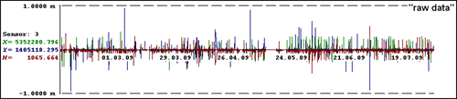
The unfiltered raw GNSS results, this means the 15-min solutions from the baseline processing step, of one exemplary sensor on the slope is depicted in . As can be seen the results cannot be used without any further filter options. Outliers mainly resulting from a bad satellite constellation lead to insufficient baseline processing results and must be eliminated with a reliable, high sophisticated quality management. Furthermore it has to be considered that the height component using GNSS measurements is always worse by approximately factor 2–3 compared with the horizontal components.
Figure 6. Raw GNSS results from the baseline processor (February–July 2009). Depicted are the time series for horizontal coordinates X (green), Y (blue) and the height (red) for every 15 minutes. Some blunders and gaps are to be seen. The used sensor is a Novatel Smart Antenna.
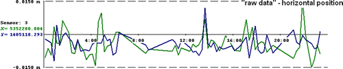
The result of the above-depicted raw data for a selected day is shown in . After all incorrect measurements are thrown out the total variation of the horizontal position spreads in an area of less than 1.5 cm. Between 06:00 and 11:00 a lack of measurements is to be seen. In this period many incorrect results from baseline processing had to be eliminated. A quite long time of a bad constellation, only few satellites in view due to huge shadowing effects of both stations (reference on stable ground and the depicted sensor at the slope) occurred.
Figure 7. Variations of the horizontal position during a representative day. Depicted are again the 15 minutes results where all outliers are eliminated and the gaps are closed.
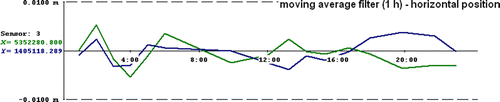
For this day, a 1 hour solution combining four single epochs using a moving average filter is shown in . The variations now clearly rest in sub-centimeter region and allow reliable conclusions about the deformation process.
Figure 8. Variations of the horizontal position during a representative day using a moving average filter of 1 hour.
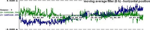
In order to make predictions of long-term trends of the deformation process the use of longer filter intervals, e.g. 6 hours, is seasonable. Referring to , even marginal movements become visual, e.g. in springtime the influence of snow melt (April–May) or periods of heavy rainfall (end of June).
Figure 9. Medium-term trend (moving average filter of 6 hours between February and July 2009). Even movements of a few millimeters are quite clearly seen.
Despite the obtained results are convincing further effort has to be made to increase reliability and accuracy. Actual work concentrates on a comprehensive quality management and on developing additional processing and estimation procedures.
4. Interoperable data access
One important aspect for a monitoring system is a widespread and easy use of the results. Status information of the observed object – including different metadata such as voltage supply – should be attained as fast as possible and easily understandable to the corresponding end users (administrators, stakeholders, and common viewers). In times of worldwide network-link by the internet interoperability has top priority. Only with standardized interfaces a trouble-free data exchange between heterogeneous systems is possible. The sensor web enablement (SWE) initiative of the open geospatial consortium (OGC®) aims to develop and introduce a worldwide standard of handling space-orientated data for an interoperable benefit. For more details see Botts et al. (Citation2007) and Walter et al. (Citation2008). Finally, every monitoring system has to be seen as a part of the spatial geo data infrastructure (SDI). According to Botts et al. (2007) the intention of the initiative is that:
-
All sensors (senor nodes) of monitoring systems reporting position (and position changes, occasionally restricted to single components like changes in inclination).
-
All connected to the Web (whereby an differentiated access of administrators, stakeholders, and other parties is to recommend).
-
All with metadata registered (for further data handling like corrections or the assessment of the system's status).
-
All readable and – as an option – controllable remotely.
Therefore providing open, standardized interfaces is one of the main criteria of an up-to-date monitoring system, respectively, GSN. Data exchange can be handled in two different ways: directly forwarding sensor measurements for example with a sensor observation service (SOS), which coincidentally needs a detailed technical description of the connected sensor. This can be realized via sensor modeling language (SML). If only prepared results should be transferred to reduce the possibility of misinterpretation or for data protection reasons other interfaces have to be provided like data access via web map services (WMS) or web feature services (WFS). All these requirements comprehend the unavoidable need of a flexible and powerful (geo) database solution. The management of huge mounds of data with parallel and permanent access shared normally by several different users is due to modern data base management systems (DBMS) based on transactions by the principals of atomicity, consistency, isolation, and durability (ACID) no problem at all-in principle.
According to the claim of interoperability, the GSN at Aggenalm landslide uses an open source MySQL database. The data flow is depicted schematically in .
Figure 10. Database at Aggenalm landslide. Open standardized interfaces allow interoperable data exchange of the so called 1st level results individually for the different sensor types or as well the final results from the integrative analysis.
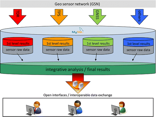
All collected data are stored in a central MySQL data base at the base station. The complex sensor raw data are processed in a first step (so called 1st level results of each individual measuring system). Without such a first processing step (see e.g. steps (2) and (3) in Section 3.3.1) data cannot be used by any party, a direct connection via the internet to the sensor is lost upon at all. Obviously such a situation has to be reflected within SWE. Parallel to the results the raw data can be stored for some reprocessing as an option. So far the processing of data can be standardized easily. At the next step an integrative analysis of all information individually performed for the monitored object must take place. The results of this important final step are purified information regarding the needs of different users. They are again provided via standardized interfaces.
6. Conclusion
The LC PDGNSS approach described above demonstrates today's possibilities in monitoring tasks where the whole approach is discussed based on the theory of WSN, respectively, GSN. The achievable data quality using low-cost GNSS equipment is characterized briefly. Finally, the assignment of a flexible database solution meets the compulsory requirement of an interoperable data exchange.
It becomes apparent that despite the results reached so far are already satisfactory there is further need for intensive research and development. Our main work actually concentrates on improving accuracy and reliability of the system and as well on the investigation of more cost-effective GNSS sensor nodes.
Notes on contributors
Jessica Glabsch is Scientific Collaborator at the Institute of Geodesy, University of the Bundeswehr Munich since 2006. Currently she is working on her Ph.D. on the optimal use of low-cost GNSS for geodetic monitoring tasks.
Otto Heunecke is Professor on Engineering Geodesy, Institute of Geodesy, at the University of the Bundeswehr Munich since 2002. He got his Ph.D. in 1995 in Hannover where he was Scientific Collaborator from 1989 to 2002. His main research topics are geo sensor networks, especially for monitoring, terrestrial laser scanning and laser tracking and automated geodetic measuring systems.
Stefan Schuhbäck is Scientific Collaborator at the Institute of Geodesy, University of the Bundeswehr Munich in the alpEWAS project since 2007. His main fields of interest are landslide monitoring and geo sensor networks where he actually is working on his Ph.D.
Acknowledgements
The alpEWAS project is funded by the German Federal Ministry of Education and Research (BMBF) and the German Research Foundation (DFG) in the geoscientific research and development program ‘Geotechnologien.’
References
- Bäumker , M. Fitzen , H-P. 1998 . High precision slow motion monitoring with low cost GPS receivers in real time In : H. Kahmen , E. Brückl , T. Wunderlich , Proceedings IAG-symposium on geodesy for geotechnical and structural engineering , 20 22 April, Eisenstadt, Austria. Vienna : Copy and Druck , 337 344
- Bill , R. 2008 . Precise positioning in ad hoc geosensor networks . EuroSDR & ISPRS hannover workshop 2008 on geosensor networks, 20–22 February .
- Botts , M. et al. , 27 Feb 2007. OGC ® sensor web enablement: Overview and high level architecture . OGC White Paper .
- Glabsch , J. 2009 . Monitoring the Hornbergl landslide using a recently developed low cost GNSS sensor network . Journal of Applied Geodesy , 3 : 179 – 192 .
- Günther , J. et al. 2008 . Developments towards a low cost GNSS based sensor network for the monitoring of landslides In : 13th FIG international symposium on deformation measurements and analysis , 12 15 May, Lisbon. Available from: www.fig.net/commission6/lisbon_2008/papers/pas04_03_gunther_mc027.pdf [Accessed May 2010].
- Hartinger , H , 2001 . Development of a continuous deformation monitoring system using GPS . In : F.K. Brunner , Engineering Geodesy, Technical University Graz . Aachen : Shaker Publishing House , ISBN 3-8265-9484-3
- Hudnut , K.W. Behr , J.A. 1998 . Continuous GPS monitoring of structural deformation at Pacoima Dam, California . Seismological Research Letters , 69 4 , 299 308 .
- Jäger , R. et al. , 2006 . GNSS/GPS/LPS based online control and alarm system (GOCA) – mathematical models and technical realisation of a system for natural and geotechnical deformation monitoring and analysis In : H. Kahmen , A. Chrzanowski , Proceedings of 3rd IAG/12th FIG symposium , 22 24 May, Baden. Available from: www.fig.net/commission6/baden_2006/pdf/GPS1/Jaeger.pdf [Accessed May 2010]
- Kälber , I. Jäger , R. 2001 . GPS-based online control and alarm system (GOCA) In : Proceedings of 10th FIG international symposium on deformation measurements , 19 22 March, Orange, CA. Available from: www.fig.net/com6_orange/index.htm [Accessed May 2010]
- Pink , S. 2007 . Entwicklung und Erprobung eines multifunktionalen Geosensornetzwerkes für ingenieurgeodätische Überwachungsmessungen . Dissertation. Scientific series of the Studiengang Geodäsie and Geoinformation, University of the Bundeswehr Munich, Issue 83
- Sohraby , K. , Minoli , D. and Znati , T. 2007 . Wireless sensor networks – technology, protocols, and applications , New York : John Wiley .
- SPS PS , 2008 Global positioning system standard positioning service performance standard , 4th ed The National Executive Committee for Space-Based Positioning, Navigation and Timing Washington, DC Available from: http://pnt.gov/public/docs/2008/spsps2008.pdf [Accessed May 2009]
- Thuro , K. 2009 . Low cost 3D early warning system for instable alpine slopes – the Aggenalm landslide monitoring system . Geomechanics and Tunnelling , 2 ( 3 ) : 221 – 237 .
- Walter , K. Niemeyer , F. Bill , R. 2008 . Geosensor web enablement in early warning systems for landslides . EuroSDR & ISPRS workshop on geosensor networks, Hannover, 20–22 February (on CD)
- Waypoint , 2007 . Waypoint Product Group, GrafNav/GrafNet user guide . Publication Number OM-200000105