Abstract
Since earthquakes, tropical storms, and floods are the three main global natural disasters causing the biggest loss, they should be the main focus of research in disaster science and disaster mitigation and prevention. This paper discusses the characteristics of these three global natural disasters from a scientific point of view, and analyses their patterns of distribution, origin and result, as well as the extent of their damage and measures of disaster mitigation and prevention. The paper, at the technical level, introduces the role of earth observation (EO) technologies in disaster mitigation, and real and quasi-real-time monitoring and assessment using advanced optical and microwave EO capacities, while digital earth technologies provide a very important role in rapidly acquiring spatial information of the disaster areas. The paper concludes by discussing the relationship between man and natural disasters, and proposes the viewpoint that man and nature should be able to harmoniously co-exist, and the importance of understanding disasters from an earth system science perspective so as to better meet the challenges of natural disasters.
1. Introduction
As natural disasters have become major threats to human life and the world economy, governments and international organizations are cooperating to promote global and regional risk management, and to improve the capability to mitigate the effects of disasters. Early international disaster reduction activities can be traced back to the International Decade for Natural Disaster Reduction (IDNDR Citation1990). It raised awareness of the significance of natural disaster reduction. In 1994, the First World Conference on Disaster Reduction was held in Yokohama, Japan, establishing the guiding principles for the Decade for Natural Disaster Reduction (ADRC Citation2006). In December 1999, the UN General Assembly adopted the International Strategy for Disaster Reduction (ISDR) to implement follow-up action for the achievements of the decade, and to promote the continuing development of disaster reduction around the world (Buckle Citation2007). Then, in 2005, the Second World Conference on Disaster Reduction was held in Hyogo Prefecture, Japan, and the Action 2005–2015: Building the Resilience of Nations and Communities to Disasters, was adopted by the Conference and has become the international blueprint for disaster reduction. In December 2006, the United Nations General Assembly agreed to establish the ‘United Nations Platform for Space-based Information for Disaster Management and Emergency Response-UNSPIDER’ as a new United Nations program (CEOS Citation2005).
This UN platform is a gateway to space-based information for disaster management support, serving as a bridge to connect disaster management and space communities, and by being a facilitator of capacity-building and institutional strengthening for developing countries in particular. Along with such UN activities, some regional and international organizations have made efforts to encourage regional cooperation in natural disaster mitigation. One of the major European efforts is the International Charter ‘Space and Major Disasters’ initiated by the European Space Agency (ESA) and the French Space Agency (CNES) in 1999, which aims to provide a unified system of space data acquisition and to deliver these data sets to those affected by natural or man-made disasters (CEOS Citation2005). Recently the Charter expanded into a world-wide program and plays an important role in natural disaster mitigation activities.
In Asia, the most disaster-prone continent, the Asian Disaster Reduction & Response Network (ADRRN) was formed in 2002 following an agreement between the Asian Disaster Reduction Center (ADRC) in Kobe, Japan and the United Nations Office for Coordination of Humanitarian Affairs (UN OCHA). This brought together more than 30 NGOs from regions all over Asia to work together for disaster reduction and response (IAP Citation2009).
In December 2004, nearly a quarter of a million people lost their lives and over 1.6 million were displaced from their homes in the devastating Indian Ocean tsunami. In the aftermath of this shocking event, the InterAcademy Panel (IAP) approved a proposal of natural disaster mitigation proposed by the Chinese Academy of Sciences. Then an international study panel was established and produced a report. This paper introduces part of the results of the IAP report. Statistics have shown that the great natural disasters have resulted in a death toll of up to 2 million persons and economic losses up to US$1950 billion from 1950 to 2008 (IAP Citation2009). The most death toll and losses are from the three major natural disasters: storm; earthquake; and flood. So this paper mainly deals with these three kinds of disaster.
2. Earthquake disasters
An earthquake is a sudden movement of the Earth's lithosphere (its crust and upper mantle), which is caused by the release of built-up stresses within rocks along geological faults, or by the movement of magma in volcanic areas. Smaller earthquakes occur frequently, but annually, only as many as 18–20 reach a magnitude above Ms 7. Approximately 40 disastrous earthquakes have occurred since the end of the twentieth century, and the total death toll is nearly 1.7 million. This number is about 50% of all victims of natural disasters. Most earthquakes (80%) occur in the oceans, mainly in the subduction zones. Earthquakes occurring in such regions have a frelatively large magnitude and they are also deep. These earthquakes can cause tsunamis. Continental earthquakes are less frequent than those in the ocean and they occur mainly on the boundaries of continental plates or the boundaries of active blocks (Johnston and Schweig Citation1996, China Earthquake Administration Citation2005).
Like other disasters, earthquakes and tsunamis can be sudden, seriously destructive, and create long-lasting social, environmental, and economic problems. However, compared with weather-related or biological disasters, damage from earthquakes is multiplied by the impossibility of accurate and timely forecasting, and afterwards by difficulty in timely response and rescue efforts.
Earthquake disaster risk zonation is an important tool in earthquake disaster prevention. Most developed countries have accurate and detailed earthquake disaster zoning and risk assessment maps. However, it is necessary to continue to evaluate the potential dangers of earthquakes by improving theory and methodology of risk assessment, based on seismic activity and active fault monitoring. It is also crucial to document disaster-caused changes, disaster degree, risk, and loss estimations (Long and Zelt Citation1991, Ma Citation2005, Liu Citation2007, Liu et al. Citation2007).
Engineering analysis for structural collapse prevention and deformation of buildings in the event of a major earthquake must be implemented everywhere. Related research must continue to be carried out on the seismic structure of active faults, mechanisms of earthquake generation, assessment of potential earthquake activity, and potential losses.
The suddenness and destructiveness of earthquakes often result in rescue decisions being delayed, chaotic, unplanned, and unscientific, thus resulting in even greater loss. It is critical to improve the means and methods of rescue in all countries. In order to improve the capabilities of emergency response and rescue, research should comprehensively review emergency rescue systems, rapid disaster-evaluation technologies, communications, and decision-making methods (Shen et al. Citation2003, Qu et al. Citation2004, Wang et al. Citation2008). There is also a great need for improved early warning systems. The lack of such a system resulted in the long-distance devastating damage following the Indian Ocean tsunami of 2004.
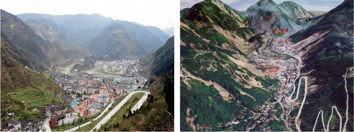
A systematic assessment of emergency and assistance needs before an earthquake would serve in determining the disaster extent, quantify assistance needed, and establish a disaster-planning database and disaster-needs forecast. The resulting disaster aid model could help to rapidly make decisions on the level of required assistance within 2–3 hours after large-scale earthquakes and an hour after middle-small-scale earthquakes. For example, the Ms 8.0 Wenchuan earthquake resulted in a large number of deaths and injuries as well as disruption of electricity, communications, transportation lines, and water supplies. shows the appearance of Beichuan County Town before and after the earthquake. Major difficulties were encountered in the response time for rescue and disaster-relief operations because of the unknown situation on-site. The Chinese Academy of Sciences, in cooperation with other organizations, used remote-sensing techniques to immediately assist with disaster relief. Through acquiring, processing, interpreting, and analyzing remote-sensing data, a series of reports on disaster reduction were immediately submitted for earthquake assistance and disaster relief at all government levels. Additionally, digital earth technologies, such as using Google Earth immediately after the earthquake to acquire spatial information of the disaster area, played a crucial role in assisting scientists to understand geological structures and plan for the subsequent further studies (Guo Citation2009, Citation2009a, Citation2009b, Citation2010a).
Figure 1. Beichuan County Town of Wenchuan earthquake area in May 2008. Left: oblique photo before the earthquake; Right: 3-D airborne remote-sensing image after the earthquake.
3. Tropical cyclones and storm surge disasters
Tropical cyclones are warm-core meteorological systems that develop over tropical and subtropical ocean waters, with a surface temperature of 26.5°C or more, and in areas of small changes in wind velocities with height.
There are, on average, around 90 tropical cyclones annually (including tropical storms, strong tropical storms, cyclonic storms, typhoons, hurricanes, and strong cyclonic storms). They occur in the northwest Pacific Ocean, the northeast Pacific Ocean, the southwest Indian Ocean, the Atlantic Ocean and Caribbean Sea, and the southwest Pacific Ocean. Storm surges are caused by tropical cyclones, which in turn are caused by strong winds and sudden decrease in atmospheric pressure near their centers. This change in pressure causes a sudden and sharp rise in coastal water levels (Henderson-Sellers et al. Citation1998, Knutson Citation2002, Emanuel Citation2005, The State Council of the People's Republic of China Citation2005, The Statement on Tropical Cyclones and Climate Change Citation2006, The Summary Statement on Tropical Cyclones and Climate Change Citation2006).
World Meteorological Organization (WMO) statistics show that tropical cyclones and the associated storm surges and torrential rains are the most destructive hazards in terms of deaths and material losses. According to the third assessment report on global climate change issued by the WMO and the Intergovernmental Panel on Climate Change (IPCC), since 1750, overall climate warming has been in part a result of human activities. The surface temperature of most tropical waters has already increased by 0.2–0.5°C (IPCC Third Assessment Report-Climate Change Citation2001). There are indications that in the future tropical cyclones may increase in intensity, although there are uncertainties regarding the overall frequency of tropical cyclones in a warming world. With increasing globalization, it can be inferred that disasters related to typhoons will have increasing socio-economic impact, particularly in developing countries.
In an attempt to reduce the effects of cyclones and storm surges, science and technology have developed surveillance systems and methodologies for disaster prediction and early-warning. These systems of spatial observation technology, supported by powerful computers and telecommunications facilities, have resulted in the development of numerical weather prediction techniques that permit significantly improved real time forecasts of weather-related hazardous phenomena. Some of the major advances of these sciences include: (1) the availability of an unprecedented amount of new non-traditional observations, in particular from earth observation (EO) satellites with onboard optical scanners and imaging radars; and (2) the considerable progress in the scientific understanding of dynamic and physical processes in the atmosphere and their interactions with the oceans.
Although over the past two decades several nations have made remarkable progress in typhoon surveillance, forecasting and alerts, there are still material predictive errors of the estimation of storm tracks and in the accuracy of predicting their intensity, path, wind, and associated precipitation. Forecasting and early warning systems for storm surges have mainly been established in developed countries, but Cuba and Bangladesh are examples of developing countries where new surveillance and forecasting systems have had very positive impact on disaster mitigation (The Statement on Tropical Cyclones and Climate Change Citation2006, The Summary Statement on Tropical Cyclones and Climate Change Citation2006).
4. Flood and drought disasters
Floods and droughts have devastating consequences. According to the Asian Disaster Reduction Center, half the population world wide who suffered natural disasters was affected by floods and one third by drought during the period from 1975 to 2005. The World Disaster Report, published by the International Federation of Red Cross and the Red Crescent Societies, showed that over the past 20 years, deaths resulting from flood-related disasters, including floods, landslides, storm surges, and tsunamis, accounted for 83.7%, 2.7%, 12.4%, 0.7%, and 0.5% of the total disaster-related fatalities in Asia, Africa, America, Europe, and Oceania, respectively. The statistics also indicated that developing countries experienced more casualties when they were struck by natural disasters (World Meteorological Organization & Global Water Partnership Citation2003, Lehner et al. Citation2006).
The increasing losses resulting from floods and droughts in both developed and developing countries indicate that disaster mitigation is not a simple matter related to economic development, but rather a more complex issue in which science and technology could play an important role (Flowers Citation2003, Cheng Citation2006).
The mainstream water-related management strategy in the twenty-first century has shifted from single-purpose engineering measures to comprehensive management for flood and drought prevention. With the apparent direction of future climate change, extreme weather events are predicted to occur more frequently. The probability that these events will cause greater damage has also increased due to rapid population growth and construction in areas of high flood risk. Increased vulnerability of life and property brings with it an increased demand for protection against the elements of nature. However, traditional methods of flood control and drought relief are becoming more complex as we face the deterioration in water distribution, intensification of soil erosion, degradation in aquatic ecology, and overall regional water shortages.
With existing and the future challenges related to floods and drought, there are several crucial issues facing research scientists and governments. Under the premise that floods are inevitable, how can we reduce fatalities and property loss and improve our knowledge to take advantage of the positive aspects of floods and thus transform negative relationships into beneficial interactions between humans and nature? In order to plan for management for the disasters, we need to select a risk-management model that fits local conditions.
Overall, we must exercise non-engineering measures including laws, economics, administration, and education to enhance the integrity and long-term benefits of flood control engineering projects. Finally, we have to perfect the emergency response management system and operations for severe floods.
5. Earth observation (EO) for natural disaster mitigation
EO comprises in situ observations, which is direct observation carried out in close proximity to the object or phenomenon of interest, and remote sensing or observation from a distance (CEOS Citation2005). There is an increasing use of EO technologies in post-disaster damage assessment.
Examples of EO at work today include the thousands of data buoys operating in the world's oceans, hundreds of thousands of land-based environmental monitoring stations, tens of thousands of observations from aircraft platforms and over 50 environmental satellites orbiting the globe (Guo Citation2004, CEOS Citation2005, GEOSS Citation2006).
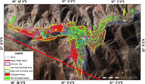
Earth observing technologies utilize information from spaceborne and airborne systems through a variety of active and passive sensors. From decades of work on disaster relief, it has been shown that EO can provide valuable information using optical and microwave technologies. Optical sensors have a long history and have continually improved both spatial and spectral resolution. Their technical advantages and familiarity give them an irreplaceable role in EO (as shown in for extracting collapsed buildings in the Yushu earthquake which occurred in April 2010 in the Qinghai Province of China). Microwave sensors are useful in situations where factors such as clouds or darkness impede the work of optical sensors. The most frequently used microwave sensors are Synthetic Aperture Radar (SAR), microwave radiometers, scatterometers, and radar altimeters (GEOSS Citation2006, Guo Citation2010a).
Figure 2. Image/Map of spatial distribution of collapsed buildings interpreted from airborne optical remote-sensing image overlaid with inducing factors generated in April 2010 for the Yushu earthquake area in western China (Guo et al. Citation2010b).
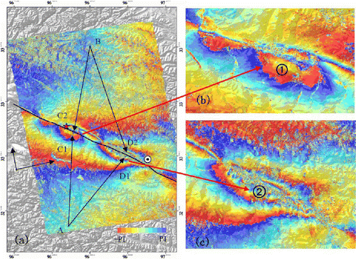
In terms of earthquake disaster mitigation and relief, EO is used for regional structural/tectonic mapping and other topographic and land-use base-mapping for emergency relief logistics, estimation of settlement and structural vulnerability (e.g. building design) and exposure (e.g. proximity to active earthquake zones). EO also contributes to damage assessment mapping using high-resolution satellites, a primary need for relief agencies that need to locate victims and assess risk. SAR interferometry (InSAR) is increasingly being used for the mapping of seismic ground deformation. InSAR data provides information on pre-, co-, and post-seismic deformation and therefore contributes to the mitigation phase by adding to the spatial understanding of fault mechanics dynamics and strain. shows radar interferogram of the Yushu earthquake, from which the spatial distribution of surface deformation field is clearly shown. Coseismic deformation field within the image is about 82 km long and about 40 km wide along the fault. From the distribution of interferometric fringes caused by Yushu seismic deformation field, we can see that the distribution of the coseismic deformation is centered around the Ganzi-Yushu fault zone. For more information on the results of interpreting the image, please refer to Guo et al. (Citation2010c).
Figure 3. Co-seismic deformation map from ALOS/PALSAR data of Yushu earthquake area in April 2010, where (a) shows differential interferometric phase map; (b) differential interferometric phase of instrumental epicenter; and (c) differential interferometricphase of macro epicenter.
For floods, both optical and radar satellites have been widely used to quantify catchment basin characteristics, such as watershed boundaries, elevation and slope, land cover, as well as environmental variables such as soil moisture, snow pack, temperature, vegetation indices, and evapotranspiration. They have also been used operationally for flood and drought monitoring, mapping, early warning, and damage assessment. As a weather-related disaster, the study of droughts has used a number of satellite-based programs and they are providing improved details relating to existing and projected researches. However, the potential contribution of existing satellites has still not yet been fully exploited (Scofield and Margottini Citation1999, Stancalie Citation2005).
Typhoons and hurricanes occur in the vast tropical ocean/seas where they are mainly monitored using EO. Current research is focusing on improving EO for weather forecasting and also improving the timeliness, quality, and long-term continuity of observations to help revise current forecasting models (Klotzbach Citation2006).
6. Human beings and natural disasters
Natural hazards resulting from geophysical and hydrometeorological events are uncontrollable forces that impact the environment in which we live. Earthquakes and volcanic eruptions can alter the earth's topography, while flooding and drought have a great impact on life forms. Often, hazards become disasters that cause human and economic losses, and the magnitude of these losses is increasing. Complex infrastructure, population growth, and widespread poverty are some of the reasons, but human activities such as land-use practices exacerbate the effects. This is evident both in developing and developed countries. Further, there is now convincing evidence that climate change is contributing to an increasing frequency and intensity of some types of ‘natural’ events. However, as for preparing to meet these changing hydrometeorological conditions, we must use science and technology to explore the potentially positive aspects of a changing climate.
Lack of scientific and technological tools or experience cannot explain why so many of the hazards become disasters. Knowledge, experience and tools exist, but there is a problem of access to and sharing of information and data, and a need for science to be incorporated into social and political decision-making. In order to (1) reduce risks and vulnerability, (2) mitigate the effects of natural disasters, and (3) improve rescue operations, a multi-disciplinary approach is necessary involving natural, social, and political sciences. These issues are of global concern and fit well into the Digital Earth concept.
The Earth has a history of 4.5 billion years, and the occurrence of disastrous events is merely a natural phenomenon in its long-term evolutionary process. The existence of mankind is in concomitance with natural calamities. Although humanity must wage struggles with natural disasters, their actions must be in accordance with the idea that human beings should be getting along with nature harmoniously.
Notes on contributor
Huadong Guo is the Director-General of the Center for Earth Observation and Digital Earth, Chinese Academy of Sciences. He is Secretary General of the International Society for Digital Earth (ISDE), Editor-in-Chief of International Journal of Digital Earth, and a member of the CODATA Executive Committee. He is currently a Principal Scientist of National Basic Research Project on ‘Research on the Mechanism and Methodology for Sensitive Factors of Global Change Using Space Technologies,’ and was Principle Investigator for more than 20 key national projects or programs in China, also PI for over 10 international remote-sensing projects. He has published over 200 papers and 12 books.
Acknowledgements
The author appreciates the contributions of the team members, especially Feng Qiang, Lars Hernroth, Ling Thompson, Cheng Xiaotao, Qu Guosheng, Xu Yinglong, Yu Fujiang, Liu Jie, Wang Changlin, John van Genderen, Anthony Lewis, and Zhu Lanwei. This work has been supported by the IAP and the National Basic Research Development Program of China (Grant No. 2009CB723906).
References
- ADRC 2006 Natural disasters data book-2005 [online]. Available from: http://www.adrc.asia/publications/databook/DB2005_e.html [Accessed 28 April 2010]
- Buckle P. 2007 Building partnerships for disaster risk reduction and natural hazard risk management Provisional Report, The Cairo regional workshop, joint organization of UN/ISDR and the World Bank, 18–21 April 2007, Cairo, Egypt. 18–21 April 2007
- CEOS 2005 The use of earth observing satellites for hazard support: assessments & scenarios In: Final report of the CEOS Disaster Management Support Group, NOAA, 98
- Cheng X.T. 2006 Flood and drought evaluation and management In: General Report for Question 87 of ICOLD, Barcelona
- China Earthquake Administration 2005 Nation earthquake disaster mitigation planning (2006–2020) [online]. State Council. Available from: http://www.lj9623.cn/xxdt/ShowArticle.asp?ArticleID=41 [Accessed 14 April 2010]
- Emanuel , K.A. 2005 . The increasing destructiveness of tropical cyclones over the past 30 years . Nature , 326 : 686 – 688 .
- Flowers R.B. 2003 Flood management: a key to sustainable development and integrated water resources Keynote speech for opening plenary of flood day in 3WWF, 2003(2)
- Global Earth Observation System of Systems GEOSS 2006 Third IGOS Cryosphere Workshop 16–18 October 2006, ESA, ESTEC, Noordwijk, Netherlands
- Guo , H. 2004 . Earth observation and sustainable development , Beijing : Science Press .
- Guo H. 2009 Atlas of remote sensing of the Wenchuan earthquake London Taylor and Francis
- Guo H.D. Li X.W. Zhang L. 2009a Study of detecting method with advanced airborne and spaceborne synthetic aperture radar data for collapsed urban buildings from the Wenchun earthquake Journal of Applied Remote Sensing 3 31695
- Guo , H.D. 2009b . An improved automatic detection method for earth-quake-collapsed buildings from ADS40 image . Chinese Science Bulletin , 54 ( 18 ) : 3303 – 3307 .
- Guo H.D. et al. 2010a Damage consequence chain mapping after Wenchuan earthquake using remotely sensed data International Journal of Remote Sensing (to be published)
- Guo , H.D. 2010b . Spatial distribution and inductment of collapsed buildings in Yushu, earthquake based on remote sensing analysis. Science China . Earth Science , 53 ( 6 ) : 794 – 796 .
- Guo , H.D. 2010c . Yushu earthquake synergic analysis study using multi-modal SAR datasets . Chinese Science Bulletin , 55 ( 13 ) : 1195 – 1199 .
- Qu G. et al. 2004 Urban seismic risk assessment and their application to urban planning and management of China Journal of Basic Science and Engineering Suppl 45 54
- Henderson-Sellers A. et al. 1998 Tropical cyclones and global climate change: a post-IPCC assessment Bulletin of the American Meteorological Society 79 9 38
- International Decade for Natural Disaster Reduction IDNDR, [online] 1990 Available from: http://www.cira.colostate.edu/cira/ramm/hillger/IDNDR.htm [Accessed 17 April 2010]
- IPCC Third Assessment Report-Climate Change 2001 WMO/UNEP intergovernmental panel on climate change Available from: http://www.ipcc.ch/pub/online.htm [Accessed 28 April 2010]
- Johnston , A.C. and Schweig , E.S. 1996 . The enigma of the New Madrid earthquakes of 1811–1812 . Annual Review of Earth and Planetary Sciences , 24 : 339 – 384 .
- Klotzbach , P.J. 2006 . The trends in global tropical cyclone activity over the past twenty years (1986–2005) . Geophysical Research Letters , 33 : L10805
- Knutson T.R. 2002 Special focus topic 4: global climate change and tropical cyclones Fifth international workshop on tropical cyclones Cairns, 3–12 December 2002, Australia
- Lehner , B. 2006 . Estimating the impact of global change on flood and drought risks in Europe: a continental integrated analysis . Climatic Change , 75 : 273 – 299 .
- Liu M. 2007 PIRE: a US-China partnership in research and education of intraplate earthquakes [online]. Available from: http://rcp.missouri.edu/articles/liu-nsf-china-grant.html [Accessed 13 May 2010]
- Liu , Q.Y. 2007 . Seismogenic tectonic environment of 1976 great Tangshan earthquake: results given by dense seismic array observations . Earth Science Frontiers , 14 ( 6 ) : 205 – 213 .
- Long , L.T. and Zelt , K.H. 1991 . A local weakening of the brittle-ductile transition can explain some intraplate seismic zones . Tectonophysics , 186 : 175 – 192 .
- Ma Z. 2005 Global tectonics, ppt in National Earthquake Response Support Service (NERSS) CEA. (unpublished preventation)
- Scofield R.A. Margottini C. 1999 Earth observation satellites for flood management and flash flood analysis and prediction Space Forum 4 199 222
- Shen , Z.K. 2003 . Contemporary tectonic strain rate field of Chinese continent and its geodynamic implications . Earth Science Frontiers , s1 : 93 – 100 .
- Stancalie G. 2005 Contribution of satellite remotely sensed data to flood risk mapping Geophysical Research Abstracts 7, 315. [G. Stancalie. “Contribution of earth observation data to flood risk analysis” XXII-nd conference of the Danubian countries on the hydrological forecasting and hydrological bases of water management, 30 August–3 September 2004, Brno.]
- The InterAcademy Panel on International Issues IAP 2009 Natural disaster mitigation: a scientific and practical approach Beijing Science Press
- The State Council of the People's Republic of China 2005 The national medium & long term outline of sci-tech development planning (2006–2020) [online]. Available from: http://www.cstec.org/uploads/files/National%20Outline%20for%20Medium%20and%20Long%20Term%20S&T%20Development.doc [Accessed 4 April 2010]
- The Statement on Tropical Cyclones and Climate Change 2006 The WMO international workshop on tropical cyclones IWTC-6, the San Jose, the Costa Rica. Available from: www.wmo.int/pages/prog/arep/tmrp/documents/iwtc_statement.pdf [Accessed 22 May 2010]
- The Summary Statement on Tropical Cyclones and Climate Change 2006 The WMO international workshop on tropical cyclones IWTC-6, the San Jose, the Costa Rica. Available from: www.wmo.int/pages/prog/arep/tmrp/documents/iwtc_statement.pdf [Accessed 22 May 2010]
- Wang W.M. et al. 2008 Rupture process of the Ms 8.0 Wenchuan earthquake of Sichuan, China Chinese Journal of Geophysics 51 5 1403 1410
- World Meteorological Organization & Global Water Partnership 2003 Integrated flood management, Concept Paper of the Associated Programme on Flood Management Available from: http://www.unwater.org/downloads/concept_paper_e.pdf [Accessed 6 May 2010]