Abstract
The quality control, validation and verification of the European Flood Alert System (EFAS) are described. EFAS is designed as a flood early warning system at pan-European scale, to complement national systems and provide flood warnings more than 2 days before a flood. On average 20–30 alerts per year are sent out to the EFAS partner network which consists of 24 National hydrological authorities responsible for transnational river basins. Quality control of the system includes the evaluation of the hits, misses and false alarms, showing that EFAS has more than 50% of the time hits. Furthermore, the skills of both the meteorological as well as the hydrological forecasts are evaluated, and are included here for a 10-year period. Next, end-user needs and feedback are systematically analysed. Suggested improvements, such as real-time river discharge updating, are currently implemented.
1. Introduction
Over the last decades Europe has suffered a series of severe fluvial floods with a transnational dimension, such as the Rhine–Meuse floods in 1993 and 1995, the Oder floods in 1997, and the Po floods in 1994 and 2000. Unprecedented floods affected the Elbe and the Danube river basins in 2002. In 2005, widespread and repeated flooding was again observed in several tributaries to the Danube river basin, particularly in Switzerland and Austria (De Roo et al. Citation2006) and in the lower Danube countries (Romania and Bulgaria). Only 1 year later, record floods hit again the Elbe and the Danube river basins in spring 2006. The European Environmental Agency estimated that floods in Europe between 1998 and 2002 caused about 700 deaths, the displacement of about half a million people and at least 25 billion Euros in insured economic losses (EEA Citation2003). A study by Bakker (2007) suggests that transboundary floods are typically more severe in their magnitude, affect larger areas, result in higher death tolls, and cause more financial damage than non-shared river floods do. The repeated occurrence of such disastrous floods has prompted the investigation of new strategies for flood prevention and protection, with focus on coordinated actions among countries sharing the same river basin.
In addition to flood prevention measures, flood damage can also be reduced through increased preparedness. Unfortunately, precipitation, in most cases the driving factor for floods, cannot be skilfully forecasted with single forecasts more than 2–3 days in advance. In a study based on forecasts from the European Centre for Medium-range Weather Forecasts (ECMWF), Buizza et al. (1999) showed that, although the skill in weather forecasting has generally increased to 5–6 days, e.g. for temperature, it is only of the order of 2–3 days for precipitation. In particular, in the case of extreme rainfalls, which are of special interest to flood forecasters, the lead time for skilled forecasts decreases even further.
However, this lead time for skilled precipitation forecasting can be extended by exploring ensemble prediction systems (EPS) (e.g. Tracton and Kalnay 1993, Molteni et al. Citation1996). Although produced by some meteorological services as early as the 1980s (Molteni et al. Citation1996), it is only recently that EPS have been explored for flood forecasting purposes. The European Flood Alert System (EFAS) has been developed to take advantage of these new developments.
This paper describes EFAS in brief (Section 2) followed by several quality control mechanisms (Sections 3 and 4), end-user feedback and interaction (Section 5), and new developments based on end-user feedback (Section 6).
2. The European Flood Alert System (EFAS)
The EFAS aims at increasing preparedness for floods in transnational European river basins by providing local water authorities with medium-range and probabilistic flood forecasts 3–10 days in advance (Thielen et al. Citation2009a, Citation2009b), so as to complement information provided by existing systems in the Member States. The EFAS research project started in 2003 with the development of a prototype at the European Commission Joint Research Centre (JRC), in close collaboration with the national hydrological and meteorological services. The prototype covers the whole of Europe on a 5-km grid. In parallel, different high-resolution data sets have been collected for the Elbe and Danube river basins, allowing the potential of the system under optimum conditions and on a higher resolution to be assessed. Flood-warning lead times of 3–10 days are achieved through the incorporation of medium-range weather forecasts from the German Weather Service (DWD) and the ECMWF, comprising a full set of 51 probabilistic forecasts from the EPS provided by ECMWF. The ensemble of weather forecasts is used to produce an ensemble of flood forecasts. The flood forecasts are analysed and combined to produce early flood-warning information, which is disseminated on-line () and by email alerts and warnings to the hydrological services that have agreed to participate in the pre-operational testing and development of the system.
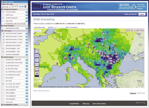
Figure 1. The on-line European Flood Alert System: the system displays locations where flooding is predicted, as well as overlays of accumulated forecasted rainfall over the forecast domain (10–14 days). Users can zoom in and get detailed information on the points where flooding is predicted.
2.1. End-user needs
A survey of the current practices and future needs of the National water authorities for the Elbe and the Danube river basins in 2003 (Thielen et al. 2003) showed that EFAS could complement national systems with the following information:
| i. | Extension of lead times. Typically, the achieved flood forecasting lead times were 2–3 days, while the desired forecast lead times exceeded the existing ones by at least 1 day. | ||||
| ii. | Interpretation of probabilistic weather and flood information. In 2003, even authorities that had access to EPS information were only able to use them qualitatively. This was partly because computational demands meant it was not technically possible to run the full suite of EPS members through their own forecasting models in real time, but also because it was felt that there was insufficient expertise to analyse and interpret the results appropriately. Integrating EPS into a real-time flood forecasting system, interpreting the results and presenting them in a concise and easy to understand way was therefore seen as an important way for EFAS to complement existing systems across Europe. | ||||
| iii. | Catchment-based information. Flood forecasters noted that they would appreciate having a physically consistent, trustworthy, and reliable overview of the flood situation in upstream and neighbouring areas. | ||||
| iv. | Sharing of information and data. Data infrastructure is particularly fragmented in Europe, leading to diverse data access rights and a variety of formats and reference systems. EFAS was seen as a possibility to bridge gaps between the different communities for improved information exchange on a European level. | ||||
‘Following these needs, a prototype for EFAS was designed and tested in pre-operational mode, with regular requests for feedback from the hydrological partner institutions receiving EFAS alerts. It has been shown that involving end-users in system design helps ensure that the resulting forecast products are more readily understood by and integrated into their operational practices of their recipients’ (Nobert et al. Citation2010).
Updated end-user needs and feedback are continuously assessed, through annual user-meetings, training sessions, direct feedback after flood alerts and events, and through targeted research by King's College London (Section 5). Since 2003 EFAS has helped inspire increasing interest in EPS among National hydrological services, though to date only very few in Europe have implemented EPS-based forecasts operationally (Cloke and Pappenberger Citation2009), and so EFAS continues to respond to a clear need in improving flood forecasting.
2.2. European Flood Alert System (EFAS) set-up
EFAS is briefly described below, while a more detailed description of EFAS can be found in Thielen et al. (Citation2009a).
Meteorological input data for EFAS are the weather forecasts of the German National weather service (DWD) and the deterministic forecasts as well as the probabilistic/EPS forecasts of the ECMWF (http://www.ecmwf.int/products/forecasts/d/charts/medium/eps/). Both the 12:00 and 00:00 forecasts are received on a daily basis. In addition, the higher resolution COSMO-LEPS ensembles are incorporated into EFAS once a day at 12:00. COSMO-LEPS (http://www.cosmo-model.org/content/tasks/operational/leps/default.htm) is the Limited Area EPS developed within COSMO consortium in order to improve the short- to medium-range forecast of extreme and localised weather events.
It is made up of 16 integrations of COSMO model, which is nested on selected members of ECMWF EPS. For the calculation of the hydrological initial conditions, observed meteorological station data (from about 2000 stations) are used.
These meteorological data are used to drive the hydrological model LISFLOOD (De Roo et al. 2000, Van der Knijff et al. Citation2010) twice daily, producing a total set of 120 hydrological forecasts daily. LISFLOOD is at the core of EFAS and can be categorised as a hybrid modelling system, merging elements of conceptual and physically distributed rainfall-runoff modelling and combining these with a kinematic routing module in the river channel. For EFAS, LISFLOOD was parameterised and calibrated on a 5-km grid for the whole of Europe with measured discharge data from more than 230 river gauging stations.
EFAS forecasts discharges for every 5×5 km grid cell, treating Europe as a natural catchment: due to lack of available data, hydropower operations, weirs and other control mechanisms cannot be taken into account. This set-up necessitates the interpretation of the resulting simulated discharge data in a model-consistent way, as direct comparison with measured discharge data is not possible. As EFAS is a pre-warning system, the main aim is to know if a forecasted discharge for a certain location exceeds a critical river discharge threshold, which would indicate a risk of flooding. To obtain these thresholds, a 18-year (i.e. 1990–2007) simulation with LISFLOOD has been carried out with interpolated observed meteorological station data. Statistical thresholds have been deduced from the resulting discharges for every grid cell. This approach has the advantage that any systematic over- or under-predictions of the model are leveled out. The two EFAS thresholds that are most important for EFAS forecasts are the ‘Severe EFAS alert level’ (SAL), i.e. a very high possibility of flooding, potentially severe flooding expected; and the ‘High EFAS alert level’ (HAL), i.e. a high possibility of flooding, bankful conditions or higher expected.
shows a forecast diagram for Prague during the 2006 flood. Consecutive forecasts are plotted to obtain a forecast ‘history’. The flood was triggered due to a sharp temperature rise while a huge snowpack was available for melting. This temperature rise was forecasted with remarkable accuracy and consistency. Even 12 days before the flood – on 14 March, indicated here as 2006031412 – a clear indication was visible of an upcoming flood. EFAS alerted the Czech authorities on 19 March, based on the older EPS system. With the new VarEPS ensembles (an upgrade of the ECMWF EPS: VAriable Resolution Ensemble Prediction System, with extended forecast range to 15 days) it is demonstrated that warning could be established even earlier. It should be noted that obtaining lead times like the 10–12 days here are not presently possible for summer floods triggered by rain only.
Figure 2. History representation of EFAS forecasts from 10 March 2006 to 14 April 2006 using ECMWF VAREPS weather forecasts for the flood in the Upper Elbe, for the gauge station Prague M. Chuchle (Czech Republic). The dates of the forecasts are shown on the left-hand side. The forecasts are shifted so that the days for which the forecasts are valid (top row) are aligned. The number in the boxes represents the number of EPS exceeding the EFAS high-alert threshold.

The flood in the Danube and Elbe in 2006 – where EFAS predicted the flood with several days lead time () and sent out daily reports to several countries for the duration of the several week long crisis – demonstrated the need for an on-line system, where EFAS users could evaluate the EFAS results themselves as well. The on-line system has been available since 2007. It is password protected, since EFAS information is only disseminated to national and regional flood forecasting centres, who have the national mandate and in many cases obligation to provide flood warning to civil protection and other national services.
3. Hits and false alerts and the skill of European Flood Alert System (EFAS)
EFAS forecasts are continuously monitored, and evaluated to check if the forecasted flood actually took place. This is done through direct contacts with its users at the Hydrological Services, through monitoring press-releases and news items on floods throughout Europe using JRC's EMM (European Media Monitoring) system, as well as through exchange of near real-time river discharge data (via the ETN-R-European Terrestrial Network for River Discharge – project, funded by JRC and executed by the Global Runoff Data Centre in Koblenz, Germany).
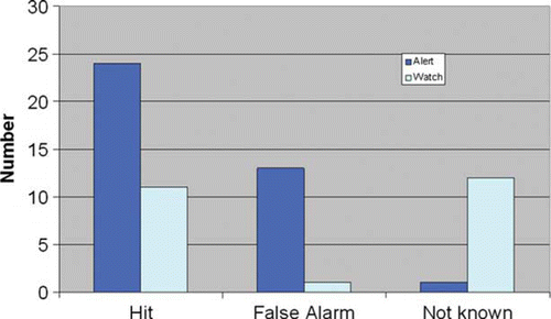
summarises the hits and false alarms of EFAS for 2007–2009. Overall the number of hits is larger than the number of false alerts, and accurate forecasts are, in many cases, achieved for 4–5 days in advance of flood events. Also it can be seen from the figure that EFAS issues approximately 25 ‘watches’ and ‘alerts’ over the entirety of Europe per year, so any single country is unlikely to receive more than 1 or 2 per year per country. False alarms are typically not perceived as negative, since the role of EFAS is to provide an early warning to the responsible authorities, a sort of wake-up call before the event is captured and confirmed by the higher resolution national systems. Comparatively little harm is done if an EFAS alert is downgraded a few days later. By contrast for a 24-hour forecast, such as might be used to trigger an evacuation, the consequences of a false alarm are much greater than for an early warning system, like EFAS, whose aim is to raise awareness of a potential flood event. EFAS is compared regularly against national flood forecasts, but the two forecasts are complementary as EFAS typically forecasts a flood with 5–6-day lead time (e.g. the Czech and Polish floods from 17 May 2010 onwards were forecasted already on 12 May by EFAS, and on 15 May by the Czech national forecast system).
Figure 3. Assessment of hits and false alarms of the European Flood Alert System for 2007–2009. ‘Alerts’ are as external warnings, where EFAS forecasts show a clear persistent signal already for at least three consecutive forecasts. ‘Watch’ cases are EFAS ‘informal’ alerts where there is a signal, but where the EFAS forecasts are more uncertain.
In addition to the examination of hits and false alerts, more in-depth scientific methods of verification are developed. Bartholmes et al. (Citation2009) examined 2 years of existing operational EFAS forecasts statistically. The skill of EFAS forecasts is analysed with several skill scores applied to the comparison of threshold exceedances between proxy-observed and forecasted discharges. Skill is assessed both with and without taking into account the persistence of the forecasted signal during consecutive forecasts. The skill-analysis showed that the use of a persistence criterion, which considers the persistence of the forecasted signal in consecutive forecasts, reduces the number of false alarms by 70% (Bartholmes et al. Citation2009), both for the deterministic as well as the probabilistic EFAS EPS-based forecasts. Using the persistence criterion far less influences the number of ‘hits’ and ‘misses’. Overall, the use of the persistence criterion therefore increases skill. The use of EPS in hydrological forecasting proved to be of great added value to a flood early warning system, as the EPS-based forecasts showed, in general, higher skill and longer lead times than the deterministic-based ones.
4. 10-Years analysis of European Flood Alert System (EFAS) performance
During the PREVIEW project (see acknowledgements), the skill of meteorological forecasts for hydrological purposes has been evaluated (Pappenberger and Buizza Citation2009, Pappenberger et al. Citation2009). The performance of the hydrological forecasts within EFAS is regularly analysed using case studies of individual flood events and false alarms. Although this analysis provides important insights into the strengths and weaknesses of the forecast system, it lacks statistical and independent measures of its long-term performance.
As a part of the testing of EFAS at ECMWF – which is also carried out in the frame of the SAFER project (http://www.emergencyresponse.eu) – an analysis was carried out on the change in quality of EFAS over the last decade (Pappenberger et al. Citation2010). EFAS river discharge forecasts have been rerun for a period of 10 years using the weather forecast available at the time. These are evaluated for a total of 500 river gauging stations distributed across Europe. The selected stations are sufficiently separated in space to avoid autocorrelation of station time series. Also, analysis is performed with a gap of 3 days between each forecast, which reduces the temporal correlation of the time series of the same station. The data are analysed with regard to skill, bias and quality of river discharge forecast.
Another issue explored through this analysis is the increase in forecasting lead time gained over the last decade, which, in turn, is closely connected to a potential theoretical limit of predictability. This estimation depends strongly on the chosen score as well as the threshold. It is computed by using recent scores for particular lead times and interpolating which lead time would be achieved 10 years ago. The difference is an estimate of the gain in lead time. Some of the deterministic scores showed no improvement; however, the values of 1 day in 7 years improvement are quoted for the Equitable Thread Score. Note that some of the gain is not related to an improvement in meteorological forecast, but to an improvement of the observational network. In the gain in lead time is shown for each lead time and the three thresholds.
Figure 4. Average gain in lead time over a decade for three thresholds and precipitation (ETS score).
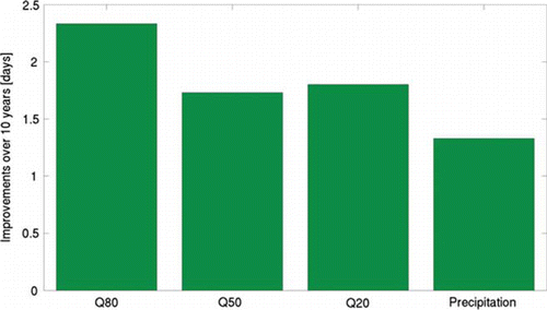
The dotted straight line indicates the average gain for precipitation. The plot indicates a considerable gain in lead time over the last 10 years. The gain increases with lead time, which may be explained by the cumulative effect a catchment has (earlier gains will more likely influence later gains due to the temporal aggregation). The gain for the 50th and 20th percentile line is on average similar to the gain in lead time of precipitation. The gain for the 80th percentile is higher. It is difficult to explain this discrepancy as no values for gain in temperature or any other surface variable are published.
Similar computations can be made for probabilistic scores such as the Brier Score or the Continuous Rank Probability Score. Gains for these scores are significantly lower (maximum at 1–2 days at lead time 10), probably because of the overall dampening effect of the catchment, which on average in Europe seems to collapse ensemble spread. This contrasts to findings in improvements of meteorological forecasts of upper airfields which increase on average at double the rate to the deterministic scores.
The 10-year simulations clearly show that the skill of the river discharge forecasts have undergone an evolution linked to the quality of the operational meteorological forecast. Overall, over the period of 10 years, the skill of the EFAS forecasts has steadily increased. Important hydrological extreme events cannot be clearly identified with the skill score analysis, highlighting the necessity for event-based case study analysis in addition to statistical long-term assessments for a better understanding of the EFAS system and large scale river discharge predictions in general. Predictability is shown to depend on catchment size and geographical location.
5. End-user feedback
In close collaboration with the EFAS development team at JRC, scientists of King's College London are examining the end-user understandings of uncertainty, and ensemble flood forecasts (Demeritt et al. Citation2010). Ensemble forecast products, like EFAS are novel and not necessarily well understood by EFAS users (Demeritt et al. Citation2007). Drawing on a set of 47 semi-structured interviews with EFAS end-users in national flood forecasting centres and civil protection authorities (CPA) in 14 European counties (Demeritt et al. Citation2010), this Economic and Social Research Council (ESRC) funded project has highlighted the difficulties often faced by EFAS end-users in understanding unfamiliar EPS products and in making use of EFAS forecasts for operational purposes. It is clear from end-user feedback that the informational value of EPS forecasts in general, and of EFAS products in particular, is understood in a variety of sometimes contradictory ways. While some users regard the ensemble mean as a useful summary of forecast uncertainty, others dismiss its informational value. Some EFAS users look to EFAS forecasts to help confirm local deterministic models, despite the fact that EFAS is not designed to do this. While there is a general appetite for EPS forecasts among EFAS end-users, there is also, clearly, a need for training to improve the understanding of EPS and its potential operational uses. User feedback indicates that the operational utility of EFAS as a pre-alert for forecasting centres is widely accepted, but there is debate about whether probabilistic forecasts would be useful for or can be successfully communicated to CPAs. In this context, one key issue is the translation of EFAS alert thresholds to locally meaningful values. Better communication of the scientific basis for EFAS thresholds and their relationship to river discharge values is required.
6. Responding to end-user feedback: discharge-updating
From the outset EFAS communicated threshold-exceeding flood alerts only, but end-users have also requested EFAS to forecast river discharge values. While discharge values are generated by EFAS, they must be interpreted with great care, due to an accumulation of uncertainties: initial conditions uncertainty (limited available real-time observations of weather and river discharge), model uncertainty (MU) and weather forecast uncertainty. Therefore, EFAS has not communicated discharge values before.
In order to respond to the end-user requests, and given the recent availability of real-time river discharge in EFAS, EFAS has been further developed to include an error-correction method for points along the river network, where observed discharge data are available. Using the new method, probabilistic flood forecasts are produced by the integration of hydrological and meteorological uncertainties. This new method minimises the error of the timing, the differences in the volume and the magnitude of the peak itself between observed and simulated flood events (Bogner and Kalas Citation2008, Bogner and Pappenberger 2010).
The error correction is achieved by simple AutoRegressive models with eXogenous input (ARX), relating the observed discharge value y t at time t to the previous discharge y t–1 with time lag 1 and the simulated model output x t at some station. The Bayesian Uncertainty Processor (BUP) method is used to estimate the full predictive uncertainty (PU) and is divided into a so-called Hydrological Uncertainty Processor (HUP), capturing all model uncertainties, the Input Processor taking into account the meteorological forecast uncertainty forcing the hydrological model and finally the Integrator, which combines the HUP and the Input processor optimally (Krzysztofowicz Citation1999). According to this methodology, the HUP has been applied to the error corrected discharge series at first in order to derive the predictive conditional distribution under the hypothesis that there is no input uncertainty. The uncertainty of the forecasted meteorological input will be derived from the EPS and the Input Processor maps this input uncertainty into the output uncertainty under the hypothesis that there is no hydrologic uncertainty.
Thus the goal is to get an estimate of the conditional probability distribution of the future observed quantity (i.e. the discharge in the next days) given the available sample of model predictions by integrating optimally the hydrological and the input uncertainty.
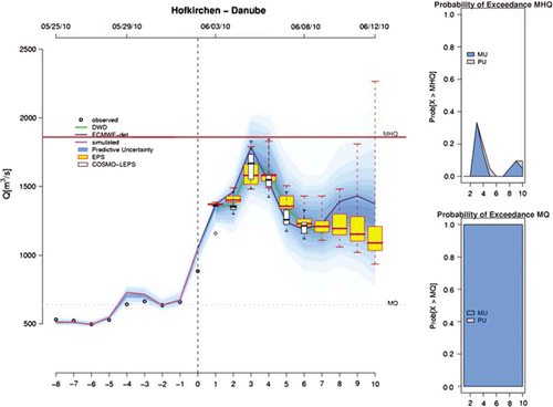
shows an example of the error-correction method. During the dissemination, only the corrected results are shown to avoid confusion and reduce the information. The method corrects the initial model estimate, which is based on a (limited) number of available weather stations, while using real-time river discharge transmitted by the local authorities to EFAS. Then the estimated MU is combined with the ensemble spread of the EPS forecasts to obtain the ‘predictive uncertainty’.
Figure 5. Example of the error-correction application for station Hofkirchen (Germany, Danube) showing the discharge forecasts for the next 10 days starting from 5 June at time 0 (dashed vertical line). Measurements available from the previous days (–8) until time 0 are used to correct the original model estimate. In the forecast window, the MU derived from this correction, is combined with the spread in the ensemble forecast (ECMWF EPS and the higher resolution COSMO-LEPS), resulting in the ‘predictive uncertainty’ (PU) of the forecast and is shown in blue shades. On the right the probabilities of exceeding two thresholds, the mean annual maximum (MHQ) and the annual mean discharge (MQ), are shown.
At the moment this system of error correction and integrating model and input uncertainty has been set up for operational use at some selected stations, in order to test and to obtain feedback from the user first before it will be extended to the entire EFAS domain.
7. Conclusions
The EFAS applies a continuous quality control mechanism, to monitor hits and false alerts and the skill of the forecasts. Regular interaction with end-user takes places via annual meetings and formal training sessions as well as through email contacts and dedicated site visits to solicit feedback and updated user-needs. This feedback, in turn, informs system updates, such as the inclusion of error-correction of the discharge forecasts.
It is shown in this paper that the number of hits is larger than the number of false alerts, while the annual pan-European number of alerts is around 25 each year. Furthermore, it has been shown that the skill of EFAS has improved over the last 10 years, due to both better antecedent conditions (more available data), as well as improved weather forecast skill.
Current and future research attempt to transfer the successful system to new hydro-climatologically regions such as Africa (Thiemig et al. 2010) and improve the forecast by multi-model approaches (Pappenberger et al. Citation2008, He et al. Citation2010). Furthermore, the use of near real-time satellite data (snowcover, soil moisture products, satellite-based precipitation estimates) is evaluated for improving the quality of EFAS.
Notes on contributors
Ad De Roo is a Project Leader Floods within the European Commission Joint Research Centre. He is a senior scientist with a Ph.D. in Physical Geography on the topic of hydrological and soil-erosion modelling. Both his M.Sc. and Ph.D. were completed at Utrecht University, the Netherlands, where he has also worked as a lecturer and researcher until 1997, before coming to JRC. He developed the physically based catchment models LISEM for soil erosion and LISFLOOD for flood simulation and co-developed the LISFLOOD-FP model for flood inundation. His main expertise is in hydrology, hydrological modelling, GIS, soil physics and soil erosion.
Jutta Thielen is currently leading the development of the European Flood Alert System (EFAS) the European Commission Joint Research Centre. She joined the JRC in 2000 and has since been working on methods of incorporating state-of-the-art meteorological weather forecasts into flood predictions on a European scale as well as on smaller scales for flashflood prone river basins. She is a senior scientist working in the field of hydro-meteorology. She studied meteorology at the University of Karlsruhe (M.Sc. in 1989) in Germany and completed her studies in Environmental Science at the University of Lancaster, in the UK, with a Ph.D. on the influence of hilly terrain on the outbreak of severe storms (1994). Since then she has developed her professional career in the field of high-resolution numerical modelling of severe weather including rain, hail, and windstorms, and on the interfacing of meteorological models with hydrological models.
Peter Salamon graduated as a M.Sc. in Applied Environmental Geoscience in 2001 at the Eberhard-Karls Universität in Tübingen (Germany). After working 2 years for an international environmental consulting company (AMEC Earth & Environmental) in Frankfurt (Germany) as a Project Manager, he started his doctorate studies in 2003 at the Polytechnic University of Valencia (Spain), where he received a Ph.D. in Hydraulic and Environmental Engineering in 2006.
During his research activities and professional career he has gained experience in hydrogeology, numerical modelling of subsurface flow and transport processes, geostatistics, aquifer remediation design, uncertainty analysis, environmental risk assessments and hydrological modelling. He joined JRC in October 2006 where his main working tasks are the support and development of the European Flood Alert System, flood risk mapping and the development of data assimilation techniques for operational flood forecasting.
Konrad Bogner is a scientific officer at the EC-JRC, working in the field of probabilistic flood forecasting. After finishing his studies on forestry at the University of Natural Resources and Applied Life Sciences, Vienna, he completed his Ph.D. at the Institute of Water Management, Hydrology and Hydraulic Engineering in the field of stochastic rainfall modelling. Next, he was a research associate in Switzerland (EPFL, EAWAG) and at the Bavarian Water Resources Agency, working on flood forecasting and hydrological modelling. In the year 2006 he joined JRC.
Sebastien Nobert is a postdoctoral research fellow in the Hazards and Risk Research Group with the Geography Department at King's College London. After a first degree in anthropology from the Université de Montréal, he did a M.Sc. in archaeology from Sheffield University in the UK, before completing his Ph.D. in human geography at the University of Edinburgh on the controversies over boreal forest management in Québec. For the past 3 years, he has been working on the contested understanding, communication and management of flood risk in Europe. He has published in Meteorological Applications, Journal of Flood Risk Management, and the Scottish Geographical Journal.
Hannah Cloke is a Senior Lecturer in Physical Geography specialising in hydrological modelling. She obtained a B.Sc. (1999) and Ph.D. (2003) in Geography from the University of Bristol. Hannah is a member of the Hazards and Risk and Environmental Monitoring and Modelling research groups within the Department of Geography at King's College London. Her current research includes climate impact on flood hazard, ensemble flood forecasting, streamflow generation mechanisms, large-scale hydrology, and sensitivity and uncertainty analysis techniques. Hannah is a member of the NERC Peer Review College and a committee member of the British Hydrological Society and the EGU Hydrology section: Catchment hydrology. She is on the Editorial board of the journals Hydrology and Earth System Science and Hydrology Research, and is a guest Editor of the ‘Large scale hydrology’ special issue of the journal Hydrological Processes.
David Demeritt is a Professor of Geography and director of the Hazards and Risk Research Group at King's College London as well as serving on the NERC Peer Review College and the Grants Assessment Panel for the ESRC and as book reviews editor for Environment and Planning A. His research focuses on the articulation of environmental knowledges, especially scientific and technical ones, with power and the policy process, and in that context he is a PI on the ESRC-funded project, ‘Europeanizing Flood Forecasting and the Geographies of Risk and Science in the EU’ (RES-062-23-0913), which supported his contributions to this paper.
Jalal Younis is a senior researcher on Hydrology and Flood Forecasting, working for the Czech Hydrometeorological Institute (CHMI) since 1998. Mr. Younis was awarded B.Sc. in Geology in 1979 from the University of Mosul then M.Sc. in Hydrogeology in 1983. In 1994, after being awarded his Ph.D. from the Technical University of Ostrava – The Czech Republic he worked as an external lecturer for the department of Engineering Geology at the same university. From 1996–1999 he worked for the Academy of Sciences of the Czech Republic, Institute of Geonics, Ostrava as a scientific researcher. In 1998, with an overlap working for both Czech Academy of Sciences and Czech Hydrometeorological Institute as mentioned before. Between 2003 and 2008 he worked for the JRC in the EFAS team. At present, he works for the CHMI in Prague on hydrological modelling and forecasting.
Dr. Milan Kalas has an M.Sc and Ph.D in hydrology and water management from the Slovak Technical University, Faculty of Civil Engineering, focusing on the hydrological modeling and climate change impacts on river runoff regime. He joined the JRC in 2003 and worked on various topics within to the European Flood Alert System team.
Katalin Bódis is a GIS analyst and research consultant with a Ph.D. in Earth Sciences. During her professional career in the academic sector and public administration she has gained experience in geographic information management, database harmonisation, system integration, spatial analysis, thematic cartography and web-based publishing technologies. She finished her studies in mathematics and geography at the University of Szeged (Hungary), integrated by studies at the University of Frankfurt (Germany) and at the Hochschule Karlsruhe (Germany). Postgraduate studies have been completed at the Budapest University of Technology and Economics (surveying and geoinformatics engineering), the doctoral studies (geoinformatics) at the University of Szeged (Hungary), where she has also worked as a lecturer and researcher until 2003, when she joined the JRC as a GIS expert.
Davide Muraro joined the JRC in October 2005 and provides technical assistance to the European Flood Alert System team.
Florian Pappenberger is a Consultant (Scientist) in Predictability and Diagnostics section at the European Centre for Medium-range Weather Forecasts. He obtained a Ph.D. (2004) on modelling the uncertainty in flood inundation models from Lancaster University. His research interests are: (i) from numerical weather and climate predictions to flood inundation outlines; (ii) functional classification and evaluation of hydrographs; (iii) advanced sensitivity analysis (SA) of models; (iv) socioeconomic calibration of flood models; and (v) communication of uncertainty. His expertise in flood forecasting and hydrological modelling is documented with over 50 publications in peer-reviewed journals, as peer-reviewed comments and edited volumes. He is on the Editorial board of the journals Hydrology and Earth System Science and Hydrology Research, and is a guest Editor of the ‘Large scale hydrology’ special issue of the journal Hydrological Processes.
Acknowledgements
Parts of this work have been done within the scope of the EC-funded PREVIEW (http://www.preview-risk.com) and SAFER projects (http://www.emergencyresponse.eu), with some early developments as part of the DG-RTD funded EFFS project. EFAS has been mainly developed with core-funding from the JRC, complemented with additional funding from EU bodies (DG Environment, European Parliament, IDABC programme). The Global Runoff Data Centre (GRDC) in Koblenz collaborates with the real-time discharge collection. The Economic and Social Research Council (ESRC) finances research on communication and perception of flood forecasting uncertainty within the context of EFAS. All national and regional hydrological authorities, which are members of the EFAS network, are greatly acknowledged for their collaboration, feedback and support of the system. Last but not least, the EFAS development team is much larger than the co-authors to this paper. The entire EFAS team is greatly acknowledged for their technical contributions, their science, but above all for their enthusiasm to the system.
Related Research Data
References
- Bakker M.H.N. 2007 Transboundary river floods: vulnerability of continents, international river basins and countries , Ph.D dissertation, Oregon State University .
- Bartholmes , J.C. 2009 . The European Food Alert System Efas – part 2: statistical skill assessment of probabilistic and deterministic operational forecasts . Hydrology and Earth System Sciences , 13 : 141 – 153 .
- Bogner , K. and Kalas , M. 2008 . Error correction methods and evaluation of an ensemble based hydrological forecasting system for the upper Danube catchment . Atmospheric Science Letters , 9 : 95 – 102 .
- Bogner , K. and Pappenberger , F. 2010 Multiscale error analysis, correction and predictive uncertainty estimation of a flood forecasting system . Water Resoures Research . (accepted for publication) .
- Buizza , R. 1999 . Probabilistic predictions of precipitation using the ECMWF ensemble prediction system . Weather and Forecasting , 14 : 168 – 189 .
- Cloke , H.I. and Pappenberger , F. 2009 . Ensemble flood forecasting: A review . Journal of Hydrology , 375 : 613 – 626 .
- De Roo , A., et al. , 2006 . The Alpine floods of August 2005, what did Efas forecast, what was observed, which feedback was received from end-users? Efas Post-Event Summary Report. European Commission, Eur 22154 En . P. 94 .
- De Roo , A.P.J. , Wesseling , C.G. and Van Deursen , W.P.A. 2000 . Physically based river basin modelling within A Gis: the lisflood model . Hydrological Processes , 14 : 1981 – 1992 .
- Demeritt , D. 2007 . Ensemble prediction and perception of risk, uncertainty and error in flood forecasting . Environmental Hazards , 7 : 115 – 127 .
- Demeritt , D., et al. , 2010 . Challenges in communicating and using ensembles in operational flood forecasting . Meteorological Applications , 17 , 209 – 222 .
- European Environment Agency (EEA) , 2003 . Mapping the impacts of recent natural disasters and technological accidents in Europe . Copenhagen : European Environment Agency , Environmental Issue Report No. 35 , p. 47 .
- He , Y. 2010 . Ensemble forecasting using TIGGE for the July–September 2008 floods in the Upper Huai catchment – a case study . Atmospheric Science Letters , 11 ( 2 ) : 132 – 138 .
- Krzysztofowicz , R. 1999 . Bayesian theory of probabilistic forecasting via deterministic hydrologic model . Water Resources Research , 35 ( 9 ) : 2739 – 2750 .
- Molteni , F. 1996 . The Ecmwf ensemble prediction system: methodology and validation . Quaterly Journal of the Royal Meteorological Society , 122 : 73 – 119 .
- Nobert , S. , Demeritt , D. and Cloke , H. 2010 . Using ensemble predictions for operational flood forecasting: lessons from Sweden . Journal of Flood Risk Management , 3 : 72 – 79 .
- Pappenberger , F. and Buizza , R. 2009 . The skill of Ecmwf predictions for hydrological modelling . Weather and Forecasting , 24 ( 3 ) : 749 – 766 .
- Pappenberger , F. , Thielen , J. , and Del Medico , M. 2010 . The impact of weather forecast improvements on large scale hydrology: analysing a decade of forecasts of the European Flood Alert System Hydrological Processes , doi: 10:1002/hyp7772 .
- Pappenberger , F. , et al. , 2008 . New dimensions in early flood warning across the globe using GRAND ensembles . Geophysical Research Letters , 35 (10): Art No. L10404 .
- Pappenberger , F. 2009 . The skill of probabilistic forecasts under observational uncertainties within the generalized likelihood uncertainty estimation framework for hydrological applications . Journal of Hydrometerology , 10 ( 3 ) : 807 – 819 .
- Thielen J. , de Roo A. , and Schmuck G. 2003 First LISFLOOD alert workshop-practical benefit from European research . Available from: http://floods.jrc.ec.europa.eu/efas-documents/efas-bulletins-and-other-communications/efas-workshops [Accessed 9 August 2010]
- Thielen , J. 2009a . The European Flood Alert System – part 1: concept and development . Hydrology and Earth System Sciences , 13 : 125 – 140 .
- Thielen , J. 2009b . Monthly-, medium- and short range flood warning: testing the limits of predictability . Meteorological Applications , 16 ( 1 ) : 77 – 90 .
- Tracton , M.S. and Kalnay , E. 1993 . Operational ensemble prediction at the National Meteorological Center: practical aspects . Weather Forecasting , 8 : 379 – 398 .
- Van der Knijff , J.M. , Younis , J. and De Roo , A.P.J. 2010 . Lisflood: a gis-based distributed model for river basin scale water balance and flood simulation . International Journal of Geographical Information Science , 24 ( 2 ) : 189 – 212 .