Abstract
This paper presents an overview of research studies made at the COGIT laboratory of IGN France in the fields of generalisation and symbol specification, particularly considering evaluation aspects. It then discusses how generalisation and symbol specification interact. Finally it explores some possible adaptations of the presented works in generalisation and symbol specification to cartography in the context of crisis management.
1. Introduction
Geographic information is often used by end users as a support for decision-making. Therefore, on top of ensuring the content quality of geographic information, it is very important to communicate this information to the end user in a form that really helps him to take decisions. When the support used for decision-making is a map, it is important that this map has a good readability. This is especially crucial in the applicative context of crisis management, because decisions taken in this particular application case often have serious consequences. This particularly holds for rapid cartography products, produced and used during the crisis, as the decisions taken on the basis of these products potentially have a strong human impact.
Making an efficient map to answer a given need presupposes to understand this need, and then requires: (1) to select and prepare the relevant data; and (2) to design the map in order to meet the need, i.e. to build a specific cartographic message ().
Figure 1. Efficient map design process. In bold, the stages on which this paper focuses.
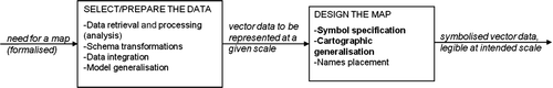
The first stage – selection and preparation of the data – includes the retrieval of relevant data, the schema transformations in order to match the conceptual schema of the map, data integration in order to manage consistency issues between different data sources, generalisation in order to meet the relevant level of detail. At this stage, only model generalisation occurs, i.e. the level of detail is decreased (by means of selection, aggregation, collapse from areas to lines or points, etc.) but the objects are not displaced. The second stage – map design – includes the design of map symbols and in particular the choice and associations of signs that best fit the cartographic need. A specific message concerning the crisis context has to be quickly built. Then generalisation appears again but this time with a graphical aim, i.e. objects can be enlarged, displaced, or locally removed or aggregated in order to take into account the symbol widths and the legibility thresholds.
Research made at COGIT laboratory at IGN France has studied the automation of several of these subtasks, and the followed approaches make an important use of evaluation. Evaluation is indeed needed at different stages of the complete process and has three main functions (Mackaness and Ruas Citation2007): evaluation for tuning (helping the user to express his need before processing the data); evaluation for controlling (monitor the quality of the data or map during each automated step, in order to guide the automated processing); and finally evaluation for assessing the quality of the data or map after processing the data.
In this paper, we do not address the part of the mapping process that concerns the retrieval of relevant data, schema transformation and data integration. The paper presents an overview of some research made at COGIT laboratory around generalisation, symbol specification and how both interact, with a particular attention to evaluation aspects which are particularly important in the context of crisis management.
2. Evaluating generalisation
Research on automated generalisation at COGIT laboratory has tackled the three types of evaluation defined in Mackaness and Ruas (Citation2007) and listed above. Some insights regarding the evaluation of generalisation have also been identified during European surveys in which we have been involved.
2.1. Evaluation for tuning, before the generalisation process
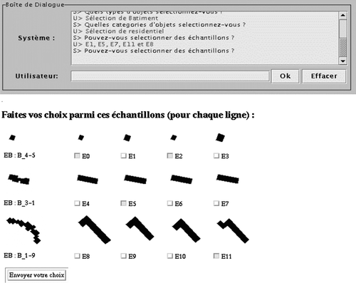
Hubert and Ruas (Citation2003) have proposed a mechanism to help the user to define the generalisation specification, by means of a human computer dialogue based on the presentation of samples. The prototype CARTABLE (), presents sample objects (left column) generalised with known parameters (four columns on the right). The user chooses the generalised objects that satisfy his needs, and his choices are interpreted as satisfying parametric values. Several series of pre-generalised objects are presented to the user. Then a convergence mechanism enables to infer the parameterisation to use in order to best fit the user needs.
Figure 2. Interface of the CARTABLE prototype (Hubert and Ruas Citation2003). The user is prompted to select the generalisations he likes.
2.2. Evaluation for controlling, during the generalisation process
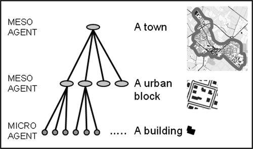
In the automated generalisation models designed at COGIT laboratory (Ruas and Duchêne Citation2007, Gaffuri et al. Citation2008) the geographic objects are modelled as agents that generalise themselves, trying to satisfy a set of constraints representing the specifications of the expected map, as first proposed in Ruas (Citation1998). These agents continuously evaluate their constraints satisfaction by means of dedicated measures, and apply generalisation algorithms to themselves in order to increase these constraints satisfactions. An agent (and thus its constraints and measures) can represent a single object (micro level), a group of objects (meso level) or a population of objects (macro level), following the proposal from Ruas (Citation2000) ().
Figure 3. The micro and meso levels of analysis, as proposed by Ruas (Citation2000).
The model more recently proposed by Touya et al. (Citation2010), which enables to let different (agent-based or not) generalisation processes collaborate in order to generalise a complete dataset, also uses micro, meso and macro constraints to formalise the generalisation specifications. It makes intensive use of evaluation to control the good progression of the generalisation process.
Examples of constraints and related measures are: for a building (micro level), constraints on the minimum size (the area should be greater than a threshold) and the granularity (the smallest edge should be long enough); between a building and a road (micro level), proximity constraint (the distance between the polygons representing their symbolised geometry should be greater than a threshold); for a road network (meso level), density constraint (the network length present by map area unit should be lower than a threshold), constraint of preservation of important roads (the roads classified the highest or allowing accessibility to major places should be kept).
2.3. Evaluation for assessing, after the generalisation process
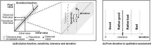
Finally, regarding evaluation for assessing the quality of generalisation, Bard and Ruas (Citation2004) proposes a model to evaluate the quality of generalised data compared to a given need. The user is asked to specify evolution functions for characteristic properties of each kind of object present on the map (again, at single object level or at group objects level). Examples of characteristic properties are the area or orientation for a building, the density of buildings for a building block. An evolution function indicates the expected final value of a property depending on its initial value (a). For instance, for a building, the orientation is expected to be preserved thus the evolution function of the orientation will be final value = initial value. Differences between expected and obtained values are then interpreted and translated into a qualitative scale composed of four degrees: very bad; bad; good; and very good (b). This interpretation uses the notions of sensitivity (threshold under which it is impossible to visually distinguish between two different values), and tolerance (threshold under which the obtained value, although different from the expected value, can still be considered correct).
Figure 4. (a) Reference evolution function for a property that should be maintained (expected final value = initial value); (b) How the deviation from the expected value is interpreted in terms of quality. Pictures after Bard and Ruas (Citation2004). With kind permission from Springer Science+Business Media. Developments in spatial data handling, Why and how evaluating generalised data?, 2004, 327–342, S. Bard and A. Ruas.
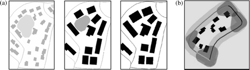
This work has been reused and extended by Schmid (Citation2008) in the context of a EuroSDR benchmarking project aiming at evaluating automated generalisation solutions in commercial GIS software (Stoter et al. Citation2009). In the context of this project, different persons involved in the project were provided with the same test material comprising data extracts and generalisation specifications to meet, expressed as a set of constraints to satisfy. These persons tried to obtain the best possible generalisation result from different commercial software, and the obtained outputs were then evaluated both automatically and interactively. One of the outcomes of this study is that some constraints appear to be universal: the persons who generalised the data tried to satisfy them even when they were not part of the specifications, and the persons who had designed the specifications validated these initiatives afterwards. The concerned constraints are mainly related to the preservation of relative positions and spatial distribution. shows two examples of measures that contribute to assess spatial distribution preservation. The first measure (a, from Bard Citation2004), is based on the detection of free spaces within an urban block proposed in Boffet and Rocca-Serra (Citation2001). Comparing the number of free spaces before and after generalisation helps to identify cases where the spatial distribution of buildings has changed too much. The second measure (b, from Taillandier Citation2008) detects buildings that are ‘in the corner’ of a building block and thus act as landmarks. Generalisation solutions where such buildings are eliminated are then assessed as less good than others regarding the spatial distribution preservation. Now, Stoter et al. (Citation2009) identify that further work is needed on measuring the preservation of relative positions and spatial distribution – and more generally on specifying and measuring preservation of characteristics during generalisation.
Figure 5. Two measures that contribute to assess spatial distribution preservation: (a) number of free spaces inside a block (from Bard 2004, p. 170): initial state (left) and how it changes after a good (middle) and bad (right) generalisation; (b) presence of buildings in the corner of a block (from Taillandier 2008, p. 379).
3. Evaluating symbol specification
The various possibilities of symbol specification for a given set of data may lead to various maps more or less readable, understandable or adapted to the map maker's needs. Graphical semiotics research made at COGIT laboratory aims at improving the knowledge about the message built by a map maker through the map and how it is understood by the readers of the map. We say that if the readers of the map well understand the message that it conveys, then the map is considered as efficient. We thus define an efficient symbol specification as a good series of pairs (meaning, sign), where ‘meaning’ refers to the actual meaning the object has on the map and ‘sign’ refers to the chosen symbol. It is well-known in cartography that different signs or combinations of signs are more or less appropriate to suggest a given meaning concerning an object or a relation between objects (Bertin 1967). Our research works tackle with the processes of building and improving symbol specifications, based on various methods to evaluate the quality of specifications, messages, maps face to mapmaker's needs.
3.1. Principles of research on symbol specification at COGIT laboratory
Research made at COGIT laboratory on symbol specification start from the hypothesis that the meaning of each object on the map is known: the objects are classified in a geographic ontology that includes topographic items and thematic items like risk areas (with an attribute specifying the level of risk). The objective is then to specify a symbolisation, i.e. a set of pairs (objects family, symbol) where an object family is a set of objects matched to the same element of ontology, i.e. having the same meaning. The relations of association, difference, order (within a geographic theme) or quantity that should be shown between object families are deduced from known relations between the elements of the ontolo gy to which they are matched. The relative importances of the themes are stemming from the user specifications. The aim is then to choose signs that express the right meaning of the objects and of the relations between objects.
3.2. Acquisition and organisation of cartographic knowledge necessary to symbol specification
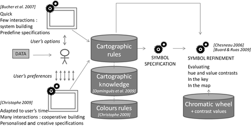
The various research works at COGIT laboratory on symbol specification identify cartographic knowledge related to: (1) conventional colours associated to given themes (e.g. water in blues), (2) contrast values that are perceived between colours, and that should be met to suggest relations of association, differences, etc., and (3) characterisation of predefined symbolisations by terms like warm, pastel, realistic, etc. To improve this knowledge, two studies have been conducted.
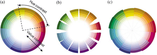
The first study proposed a methodology to analyse and quantify contrasts between the colours on a map with the help of a chromatic wheel (Chesneau Citation2005, Buard and Ruas Citation2007, Citation2009): colours on map are matched to colours on wheel. From an initial chromatic wheel defined by Chesneau (Citation2005) based on Itten (1961) (a), tests were conducted where experts were asked to assess the perceived contrasts within pairs of neighbour colours (Buard and Ruas Citation2009). shows how the initial circle is distorted to take into account the perceived contrasts of hue (b) and value (combination of lightness and saturation; c).
Figure 6. Chromatic circle: (a) distorted to take into account hue; (b) and value; (c) contrast values, after Buard and Ruas (Citation2009). Reprinted with permission. Buard, E. and Ruas, A., 2007. Evaluation of colour contrasts by means of expert knowledge for on-demand mapping. In, Proceedings, 23rd International Cartographic Conference, 4–10 August, Moscow, Russia. © International Cartographic Association (ICA), ISBN: 978-5-9901203-1-0.
The second study proposed a methodology to label a set of predefined symbolisations with characteristic properties (Dominguès and Bucher Citation2006). Experts were first asked to freely comment on maps and seven terms were identified as pertinent properties of a symbolisation: warm, luminous, pastel, rich, sober, realistic and innovative. Then a set of various symbolisations was build according to these properties and applied to datasets, resulting in a map samples database. This study was further extended by adding symbolisations corresponding to classical symbolisations used by 19 European National Mapping Agencies (Jolivet Citation2009), again applied to the same datasets. In this extended study the experts were asked to assess the same seven characteristic properties but also the efficiency of the symbolisations: the results highlighted the importance of the cultural aspect.
This knowledge is used by the works aiming at defining or improving a symbol specification presented hereafter in Section 3.3. It is now partially capitalised in the form of a structured knowledge base, the OntoCarto ontology (Dominguès et al. Citation2009).
3.3. Approaches to design and improve symbol specification
Three different approaches, all relying on evaluation, have been used to specify a symbolisation. The first one aims at improving an existing symbolisation whereas the others aim at specifying a symbolisation from scratch.
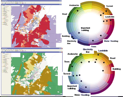
The first approach (Chesneau 2006, Buard and Ruas Citation2009) consists in analysing the colour contrasts, with the help of our chromatic wheel, on the styles in the key and between symbolised objects on the actual map (i.e. taking into account proximities between objects on the map). The system of Chesneau (2006) analyses each hue and value contrasts between the symbol specification of a graphical object and those of its neighbours; then the system verifies if each contrast is a good representation of a specific relation (difference, order and association): for instance, zones of little, medium and high risk are represented by a series of three symbols that translate an order. This order can be reached by using the colour lightness (light brown, medium brown and dark brown) or by referring to a cultural reference like the traffic lights (green, orange and red). But blue, green and red would be an irrelevant choice as it does not translate any order. Finally the system identifies the most badly contrasted theme and proposes a better colour to improve the considered contrast. Buard and Ruas (Citation2009) proposes two methods based on Constraint Satisfaction Problem and on a Multi-Agent System to analyse the symbol specification of each line in the key and evaluate hue and value contrasts, in order to determine what lines should be improved ().
Figure 7. Improvement of symbol specification by MAS from Buard and Ruas (Citation2009). Reprinted with permission. Buard, E. and Ruas, A. 2009. Processes for improving the colours of topographic maps in the context of map-on-demand. In, Proceedings, 24th International Cartographic Conference, Santiago de Chile. © International Cartographic Association (ICA), ISBN: 978-1-907075-02-5.
The second approach (Bucher et al. Citation2007) aims at producing an efficient symbolisation through a web service, with little interaction with the user. In that work, the priority is given to the respect of the meaning of the objects and the relations between objects. The user can specify expected properties of the intended map (e.g. luminous, realistic), the intended audience (e.g. children or adults) and if this map has a dominant theme. Then a cartographically correct symbolisation is immediately produced online, that highlights the dominant theme (if any) by ensuring to it a sufficient contrast value with the other themes.
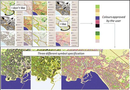
The third approach (Christophe and Ruas Citation2009) gives more space for personalisation and creativity. The objective is to help the user build a symbolisation he likes by guiding him, so that his symbolisation is cartographically correct but also adapted to his colours’ preferences. The proposed prototype COLorLEGend (COLLEG) enables a human computer dialogue between a user and a system in order to cooperatively build a personalised symbol specification, in particular colours specification (). Two ways of making a map, according to initial inspiration sources, are proposed to the user: based on map samples (supporting correct colour-theme associations) or based on existing colour palettes extracted famous paintings (supporting harmonious use of colours). According to current cartographic rules, colour rules coming from the famous paintings and colour preferences the user applies on inspiration sources, the system proposes various possible symbolisations and presents it online to the user, applied to his data. The system evaluates all these propositions in order to help the user to make a choice between them, according to his own needs: a mark assessing hue and value contrasts based on previous presented works, a mark assessing the respect of conventional rules and thus a final evaluation to classify the map as ‘cartographically correct’ or not. Finally the system proposes a refining tool based on cartographic and colours knowledge to improve any choice of colours and to finalise a personalised symbol specification.
Figure 8. Colours specification based on map samples with the prototype COLLEG (Christophe 2009).
With all these research studies, a formal model for symbol specification has been set up at the COGIT laboratory, relying on the formalisation of some of the well known rules of cartography from Bertin (1967). Several strategies for symbol specification have also been defined (with more or less interaction to the user), as well as metrics to evaluate colours contrasts. Altogether, this results in a major step towards the conception and evaluation of effective symbol specifications. summarises the different approaches for building and improving symbol specification.
Figure 9. Different approaches from C OGIT laboratory to build and improve symbol specification.
4. How generalisation and symbol specification interact
After separately presenting works that are interested in evaluating map generalisation and symbolisation, we would like to claim that generalisation and symbol specification are deeply related, and not only because cartographic generalisation takes into account the symbol widths.
This was clearly identified during the evaluation of the prototype COLLEG implementing the model of Christophe (Citation2009) introduced in Section 3. As reported in Christophe (Citation2009), COLLEG was evaluated through user tests where users were asked to design symbolisations they liked and then to report on encountered difficulties. The first series of tests resulted in users failing to design symbolisation they liked because the used data were under-generalised i.e. too detailed for the symbolisation scale (Christophe Citation2009). Actually, a second series of tests took place with the same data but generalised, where the users succeeded in designing symbolisation they liked. Several kinds of influences of the display scale and data generalisation level on symbols design have been identified. They are all related to the constraint on minimal sizes: symbolised objects have to be big enough in order to be legible on a map.
If the data are very under-generalised, the bad legibility of data due to under-generalisation takes precedence over the efficiency and harmony due to the symbol colours in the reader's visual assessment. Thus it is almost impossible for the user to assess the symbolisation. Then, still in the case of under-generalisation, the total area covered by symbols of small area objects (like buildings) is too small compared to the symbolised area related to linear objects, for which the symbol width is fixed big enough for the objects to be legible at the intended display scale. In the context of GIS in which the symbols widths are defined in screen units (pixels) and not in ground units, if the data are under-generalised for the intended display scale, the user tends to zoom in to specifying the symbolisation, in order to have the right generalisation level. Therefore, he chooses symbol widths that are correct for this ‘zoomed in’ display. And when he zooms out to reach the intended display scale, again the linear objects are over-represented. Let us notice that most of the desktop GIS only enable to express widths in pixels and not in ground units.
Finally, another consequence if the user zooms in to specify the symbolisation is that he does not see the whole mapped area while choosing the colours: while zooming out, the balance between quantities of objects can be completely different (). Therefore, contrasts of quantity between colours are modified leading to a totally new symbol specification, which has to be evaluated again according to cartographic constraints and user's preferences.
Figure 10. Variation of the balance between quantities of objects and colours depending on map extent.
To summarise, the specified symbolisation is only valid for a given range of display scales, and it should be ensured that the level of detail of the data is appropriate for this scale range as well.
5. Possible adaptation of the presented work to crisis management cartography
In previous sections, we presented an overview of research studies made at COGIT laboratory around generalisation and symbol specification, and some feedback on how both interact. In this section, we discuss how the particular applicative context of crisis management impacts the map-making process (Section 5.1). Then we consider how a generalisation process (Section 5.2) and a symbol specification process (Section 5.3) could be adapted in order to fit with this particular applicative context. Finally we propose some insights about an automated emergency mapping process (Section 5.4).
5.1. Identified specificities of cartography in the context of crisis management
From Jeanjean (Citation2009), we understood that cartography takes place at different stages in the crisis management cycle. We can roughly distinguish between two categories of processes:
| 1. | Rapid cartography, needed during the disaster or just after the disaster occurs, to quickly localise affected area and to map damages, to put crisis information together in order to optimise rapid deployment of aid and finally to organise and optimise humanitarian missions. | ||||
| 2. | More classical cartography before or after the disaster, respectively to update risks prevention (risk areas identification and urgency intervention framework planning), to manage reconstruction purposes and finally to improve forecast models and risks simulation based on data acquired during the crisis. | ||||
In terms of purposes and contents, maps may answer to simple or complex issues, and thus may contain topographic elements (access/situation maps), but also one or several thematic layers (humanitarian camps, affected area, risk propagation, flow of displaced people, etc.), which makes the map reading more complex. The variety of data needed by the crisis management requires easy access to updated data sources. Time constraints are very strong and as the data acquisition and processing stages are already time consuming, very few time (hardly a few hours) can be allocated to generalisation or symbol specifications. Therefore generalisation and symbol specification systems should be adapted in order to produce quick propositions with suitable level of generalisation and symbol specification.
Moreover, the final display support is often paper for people working in field operations, but can also be the screen of a computer for headquarters people, or small screens of mobile devices, such as smartphones that are more and more used. Maps are intended to be read in tough conditions by people who are not especially trained map readers, but also by expert decision-makers. Finally, a major characteristic of emergency maps is the uncertainty on the data they contain, due to the complexity of data acquisition and processing and the bad transmission of information in the field.
5.2. Adapting the generalisation process to the needs of crisis management
Generalisation is needed as soon as the vector data from which the map is made are too detailed for the intended scale and expected content of the map. In the case of crisis management cartography, there are several ways in which the generalisation process should be adapted depending on the context in which the map is produced.
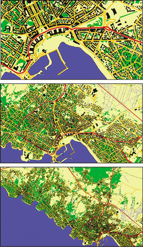
The case of maps printed in the field leads to very strong space constraints on the paper, as noticed by Duplaa (Citation2009) who reports printing in A4 a map initially intending for being printed in A0 format. In such a case, it would be important to reduce the quantity of information present on the map to the strict minimum. In the same way, the fact that the map reader is not trained and that the field conditions can be bad should lead to simplify as much as possible the topographic information: for access/situation maps, only the major landmarks should be kept, while for thematic maps only the most salient features, related to the thematic layers, should be kept. This is also valid, although less sensible, in the case of prevention maps like hazard maps: Glatron (Citation2009) shows that the layman can hardly understand where the hazard zones are situated when reading the map, because the underlying topographic layer has not been simplified enough.
Some existing research studies could be used as basis in order to adapt an automated generalisation process to the particular needs identified just above. For instance, the selection of relevant landmarks for navigation has been studied by Elias (Citation2003) in the context of 3D data, while the generalisation of navigation data to be displayed on car navigation systems has been studied by Dogru et al. (Citation2009). Generalisation of data comprising a topographic and a thematic component has not been much studied until here. We are about to start a study on this topic. Another simpler approach would be that National Mapping Agencies pre-compute topographic datasets especially simplified in order to act as reference topographic layers for thema tic information, as studied at the Ordnance Survey Great Britain. This solution is less satisfactory as the simplification of the topographic content does not take into account the nature of a particular thematic content, but it is already a step towards a better legibility of such thematic maps.
5.3. Adapting the symbol specification process to the needs of crisis management
Like the generalisation process, the symbol design process can be adapted to the context of crisis management in several ways. First, when the map has to be as simple as possible (tough conditions of use, not trained readers, etc.), the symbols should be simplified as much as possible on top of simplifying the data: i.e. they have to be generalised too. It means that few categories of objects and specific relations between them should be clearly distinguished by suitable choices of signs. We may say that conventional colours should be privileged (blues for water, greens for vegetation, etc.), and that the punctual symbols chosen to show landmarks should be explicit. But the context of emergency may quickly involve international people, and graphical semiotics choices (colours and symbols) may vary a lot depending on cultural and historical aspects: a multicultural approach for symbol specification in the case of crisis management has to be proposed in order to improve maps’ efficiency and communication between all intervention services on a crisis (firemen, decision-makers, humanitarian, politics, etc.). For instance, MacEachren et al. (Citation2009) propose to develop symbology standards for emergency mapping. Standardised symbol specifications used across series of maps produced by a same organism can also help a user to better understand a map once he is used to them.
Moreover, appropriate symbolisation should be proposed to figure the data uncertainty: spatial or attributes uncertainty; quantitative or qualitative uncertainty; uncompleteness, etc. These various types of uncertainty are often indicated by a general warning on the border of the map, whereas they should be taken clearly into account in the symbol specification, applied on a class-by-class or object-by-object basis depending on how precise the metadata on uncertainty are. A specific symbolisation should be adapted to referring objects, regarding to the type of uncertainty and also to the basic primitive used for these objects (point, line and area) – e.g. a dashed line represents uncertainty of existence better than a solid line. Some propositions to represent uncertainty have been made by Wu and Buttenfield (Citation1994) and MacEachren (Citation1995).
Finally, few research studies have been done on the adaptation of a map symbolisation when several overlayed thematic layers, with by-default renderings, are visualised on a computer screen: as the overlayed renderings may be totally unreadable or may lead to misunderstandings, automatic solutions have to be proposed to on-the-fly modify and improve renderings. A research study is on-going at COGIT laboratory, tackling some of the open research issues identified in Harrie et al. (Citation2009). Another lead would aim at improving the knowledge about what it really readable and understandable on small devices.
5.4. Towards an automated emergency mapping process
All described research work made at COGIT laboratory on generalisation and symbol specification allow us to propose insights about an integrated emergency mapping platform. Inputs for such a system could be the purpose of the map (for instance, to represent an inventory of a critical situation or a particular phenomenon such as all the destroyed buildings), the available time to build the map and the available data to represent, any quality they have. We assume that map propositions should be readable and understandable by every person likely to get involved in the crisis management. As a matter of fact, the built symbol specification has to be sufficiently cartographically correct, in order not to disturb the comprehension of the user, any skills or any culture he may have. The system should propose the user to describe expected conditions of use of the future map (to be read in critical situation, to be analyse in an office, etc.), and to give some information about the future map readers in order to tolerate a symbol specification more or less complex, suitable at least to those readers. As the existing principle of the prototype COLLEG, several different specifications may be proposed to the user, instead of just a complex one. Finally, produced maps may render well the level of data quality.
6. Conclusion and perspectives
In this paper, we summarised works done at COGIT laboratory regarding evaluation during the map-making process, and more specifically regarding the map generalisation and symbol design stages. We also highlighted the deep influence of data generalisation level in the symbol design process. Finally, we discussed how the generalisation and symbol specification processes could be adapted to the particular needs identified in the context of crisis management cartography, and gave some perspectives regarding on-going and future works. We think that crisis management application domain could benefit from advances in research on automated generalisation and symbol specification, and that reversely it raises interesting issues for these research domains.
Notes on contributors
Cecile Duchêne is an engineer in geomatics and has an MSc of cartography. She joined the COGIT laboratory of IGN-France in 1997. After 3 years as research engineer on the European AGENT project (on automated generalisation), she made a Ph.D. applying multi-agent systems to generalisation. She has been responsible for research in automated generalisation at COGIT laboratory since 2004.
Sidonie Christophe is a geomatics-agronomics engineer. She made her Ph.D. at the COGIT laboratory about the proposition of methodologies to help users to make personalised and original maps, in choosing suitable colours. She is now in postdoc in the Laboratory of Informatics of Grenoble and works about mobile technologies to analyse human behaviour.
Anne Ruas is an engineer in geomatics. She joined the COGIT laboratory of IGN-France in 1991. She made a Ph.D. applying multi-agent systems to generalisation in 1999. She is managing the COGIT laboratory since 2000 and is organising the ICA conference in 2011 in Paris. Her research domain is generalisation, semiotics, spatial analysis and simulation.
Related Research Data
References
- Bard , S. , 2004 . Méthode d’évaluation de la qualité de données géographiques généralisées. Application aux données urbaines . Thesis (PhD) . Paris VI University , France .
- Bard , S. and Ruas , A. 2004 . “ Why and how evaluating generalised data? ” . In Developments in spatial data handling, proceedings of SDH’ 2004 , Edited by: Fishe , P. 327 – 342 . Berlin : Springer .
- Bertin , J. 1967 . Sémiologie graphique: les diagrammes, les résaux, les cartes . Paris : Mouton .
- Boffet , A . and Rocca-Serra , S. 2001 . Identification of spatial structures within urban blocks for town qualification . In : 20th international cartographic conference , 6–10 August 2001 , vol. 3 , Beijing . 1974 – 1983 .
- Buard , E. and Ruas , A. , 2007 . Evaluation of colour contrasts by means of expert knowledge for on-demand mapping . In : 23rd international cartographic conference , 4–10 August 2007 , Moscow, , Russia , International Cartog raphic Association (ICA) [CD-ROM] .
- Buard , E. and Ruas , A. , 2009 . Processes for improving the colours of topographic maps in the context of map-on-demand . In : 24th international cartographic conference , 15–21 November 2009 , Santiago de Chile , Chile , International Cartographic Association (ICA) , [CD-ROM] .
- et al. ., 2007 . The need for web legend services . In : J.M. Ware and G.E. Taylor 7th international symposium on web and wireless GIS (W2GIS) 28–29 November , Cardiff . Lecture Note in Computer Science Berlin : Springer 44 – 60 .
- Chesneau , E. , 2005 . Colour contrasts analysis for a better legibility of graphic signs on risks maps . In : 22nd international cartographic conference , 9–16 July 2005 , A Coruna , Spain [CD-ROM] .
- Christophe , S. , 2009 . Aide à la conception de légendes personnalisées et originales: proposition d'une méthode coopérative pour le choix des couleurs . Thesis (PhD) . Paris-Est University , France .
- Christophe , S. and Ruas , A. , 2009 . A process to design creative legend on-demand . In : 24th international cartographic conference , 15–21 November 2009 , Santiago de Chile , Chile , International Cartographic Association (ICA) , [CD-ROM] .
- Dogru , O. , et al ., 2009 . Generalization approaches for car navigation systems . In : 24th international cartographic conference (ICC'09) , 15–21 November 2009 , Santiago , Chile , International Cartographic Association (ICA) , [CD-ROM] .
- Dominguès , C. and Bucher , B. 2006 . Legend design based on map samples . In : 4th international conference on geographic information science , 20–23 September 2006 , Münster, , Germany , Institut für Geoinformatik, Universität Münster , 55 – 59 .
- Dominguès , C. , Christophe , S. , and Jolivet , L. , 2009 . Connaissances opérationnelles pour la conception automatique de légendes de carte . In : F. , Gandon , IC 2009: Actes de 20è Journées Francophones d'Ingénierie des Connaissances , 25–29 May 2009 , Hammamet , Tunisie. France: PUG , 253 – 264 .
- Duplaa , G. , 2009 . Pyroscope: a real-time cartography experience on the fire of Valle Mala . In: et al. , VALgEO 2009: international workshop on validation of geo-information products for crisis management , 23–25 November 2009 , Ispra , Italy . Luxembourg : Office for Official Publications of the European Communities , 149 – 151 .
- Elias , B. , 2003 . Determination of landmarks and reliability criteria for landmarks . In : 5th ICA workshop on progress in automated map generalisation , [online], 28–30 April 2003, Paris. Available from: http://aci.ign.fr/BDpubli/paris2003/papers/elias_v1.pdf [Accessed September 2010].
- Gaffuri , J. , Duchêne , C. , and Ruas , A. , 2008 . Object-field relationships modelling in an agent-based generalisation model . In 11th ICA workshop on progress in automated map generalisation , [online], 20–21 June 2008, Montpellier, France. Available from: http://aci.ign.fr/montpellier2008/papers/16_Gaffuri_et_al.pdf [Accessed September 2010].
- Glatron , S. , 2009 . Perception of maps of natural risks by populations . In: et al. , VALgEO 2009: international workshop on validation of geo-information products for crisis management , 23–25 November 2009 , Ispra , Italy . Luxembourg : Office for Official Publications of the European Communities , 133 – 142 .
- et al. , 2009 . Cartographic aspects of geoportals . In: Presenting spatial information: granularity, relevance, and integration . Workshop at COSIT 2009, 21 September 2009 , Aber Wrac'h , France 27 – 39 .
- Hubert , F. and Ruas , A. , 2003 . A method based on samples to capture user needs for generalisation . In : 5th ICA workshop on progress in automated map generalisation , [online], 28–30 April 2003, Paris. Available from: http://aci.ign.fr/BDpubli/paris2003/papers/hubert_et_al_v0.pdf [Accessed September 2010].
- Itten , J. , 1961 . The art of colours: the subjective experience and objective rationale of colour . Translated edition by Ernst van Haagen , New York , Reinhold
- Jeanjean , H. , 2009 . GMES emergency response activities . Presentation [online] at VALgEO 2009: international workshop on validation of geo-information products for crisis managements, 23–25 November 2009, Ispra, Italy. Available from: http://isferea.jrc.ec.europa.eu/workshops/2009-11-VALgEO/Documents/Presentations/session1/Jeanjean_GMES.pdf [Accessed September 2010].
- Jolivet , L. , 2009 . Characterizing maps to improve on-demand cartography – the example of European topographic maps . In : D. Fairbairn . 17th conference on GIScience and research in UK , 1–3 April , Durham . Durham : University of Durham , 345 – 348 .
- MacEachren , A.M. , 1995 . How maps work . New York : Guilford , 513 pp.
- et al. ., 2009 . Developing symbology standards for emergency mapping . In : Visual Analytics Center consortium meeting , 18 August 2009 , Richland , WA . Available from: http://www.personal.psu.edu/rer198/presentations/MacEachrenETAL_2009_VAC.pdf. [Accessed September 2010].
- Mackaness , W. and Ruas , A. , 2007 . Evaluation in the map generalisation process . In : W. Mackaness , A. Ruas , and L.T. Sarjakoski Generalisation of geographic information: cartographic modelling and applications . Oxford : Elsevier , 89 – 111 .
- Ruas , A. , 1998 . OO-Constraint modelling to automate urban generalisation process . In : 8th international symposium on spatial data handling , 11–15 July 1998, Vancouver . Vancouver : International Geographical Union , 225 – 235 .
- Ruas , A. , 2000 . The roles of meso objects for generalisation . In : P. Forer , A. Yeh and J. He . 9th international symposium on spatial data handling , 10–12 August 2000, Beijing . Beijing : International Geographical Union , 3650 – 3663 .
- Ruas A. and Duchêne , C. , 2007 . A prototype of generalisation based on the multi-agent system paradigm . In : W. Mackaness , A. Ruas , T. Sarjakoski Generalisation of geographic information: cartographic models and applications . Oxford : Elsevier , 269 – 284 .
- Schmid , S. , 2008 . Automated constraint-based evaluation of cartographic generalization solutions . Master thesis report. University of Zurich. Available from: http://www.geo.uzh.ch/fileadmin/files/content/abteilungen/gis/research/msc_thesis/msc_stefan_schmid_2008.pdf [Accessed September 2010].
- et al. ., 2009 . Methodology for evaluating automated map generalization in commercial software . Computers, Environment and Urban Systems , 33 5 , 311 – 324 .
- Taillandier , P. , 2008 . Révision automatique des connaissances guidant l'exploration informée d'arbres d’état. Application au contexte de la généralisation de données géographiques . Thesis (PhD) . Paris-Est University , France .
- Touya , G. , Duchêne , C. , and Ruas , A. , 2010 . Collaborative generalisation: formalisation of generalisation knowledge to orchestrate different cartographic generalisation processes . In: et al. . Sixth international conference, GIScience 2010 , 14–17 September 2010, Zürich, Switzerland . Berlin : Springer , 264 – 278 .
- Wu , C.V . and Buttenfield , B.P. , 1994 . Spatial data quality and its evaluation . Computers, Environment, and Urban Systems , 18 3 , 153 – 165 .