Abstract
Earth observation is an effective technique that plays an important role in earthquake damage reduction and reconstruction. This paper introduces the results of dynamic analysis on monitoring and assessing heavily impacted areas affected by the Wenchuan Earthquake using remote sensing data acquired in the past 3 years from 2008 to 2010. Immediately after the disaster on 12 May 2008, the Chinese Academy of Sciences launched a project entitled ‘Wenchuan Earthquake Disasters Monitoring and Assessment Using Remote Sensing Technology.’ More than 400 images from 17 satellites and 20.2TB airborne remote sensing data were acquired to facilitate quick monitoring and evaluation of severely damaged areas in 14 counties. Results of the image analyses were forwarded on a timely basis to assist with consultative service and decision-making support. In subsequent years, in order to monitor the process of environmental restoration and reconstruction, airborne optical remote sensing images covering most of the severely damaged areas were again acquired in May 2009 and April 2010. These images were analyzed and compared along with images from 2008. Results were useful in support of further work on environmental protection and reconstruction in earthquake-damaged areas. Three typical areas were selected for illustrative purposes including Tangjiashan Barrier Lake, Beichuan County, and counties of Yingxiu and the new Beichuan. These results well demonstrate the importance and effectiveness of the utility of earth observation for disaster mitigation and reconstruction.
1. Introduction
The advent of the twenty-first century brought an increase in anthropomorphic activities and a continuation of environmental deterioration; correlated with these increases has been an increase in the impact of natural disasters that globally cause large losses of life and property. In the past five years, major natural disaster events have included Hurricanes Katrina and Rita in 2005, the Wenchuan Earthquake in 2008, the Haiti Earthquake and Yushu Earthquake in early 2010, and the Pakistan flood and Zhouqu landslide in August 2010. Earthquakes have unique features and often result in enormous loss of life and destruction of regional infrastructure. Following an earthquake, roads are destroyed and communication is largely disrupted in impacted areas. To properly arrange for immediate and effective relief work under such serious conditions, near-real-time accurate earth observations providing detailed images of the surrounding area are critical (Guo Citation2010). Beyond the need for emergency response, environmental restoration and reconstruction can also be monitored and assessed through images acquired periodically over the same areas. Major efforts have been undertaken in the mitigation of earthquake disaster in the field of earth observation (Zhang Citation1993, Zhu et al. Citation1998, Pesaresi et al. Citation2007, Ajami and Fattahi Citation2009, Ehrlich et al. Citation2009, Guo et al. Citation2010, Liou et al. Citation2010, Zhuang et al. Citation2010).
At 14:28 on 12 May 2008, an 8.0-magnitude earthquake occurred in Wenchuan, Sichuan Province, China. The Wenchuan Earthquake caused heavy casualties and financial loss. Together with a series of secondary aftershock earthquakes, road infrastructure was severely damaged and communications were hindered. It is vital to promptly acquire data for the timely monitoring and quantitative assessment of disaster conditions in support of effective decision-making for disaster relief. Immediately after the Wenchuan Earthquake, an emergency project entitled ‘Monitoring and Assessment of the Wenchuan Earthquake Disasters by Remote Sensing’ was initiated by the Chinese Academy of Sciences (CAS). A large number of remote sensing images of various types were acquired for disaster assessment and quick monitoring and evaluation of severely damaged areas. During the following years, airborne optical remote sensing images covering most of the heavily hit areas were again acquired in 2009 and 2010 to monitor the process of environmental restoration and reconstruction.
This paper introduces the results of dynamic analysis for monitoring and assessment of the areas heavily damaged by the Wenchuan Earthquake using the remote sensing data acquired in the past three years from 2008 to 2010.
2. Study area and geological background
The Wenchuan Earthquake resulted from the sudden rupture of crustal rocks due to the accumulation of stress concentration in the seismic structure. In the western part of China, the Indian Plate collides with the Asian Plate at a speed of 50 mm per year. This results in a rapid uplift of the Qinghai-Tibet Plateau. Meanwhile, the slow eastward movement of highland materials produces an eastward extrusion along the Longmen Shan structure in the eastern edge of the highlands. This extrusion is tenaciously resisted by the rigid block under the Sichuan Basin. This leads to frequent tectonic activity and crustal stress concentration resulting in an earthquake-prone area. After long-term accumulation, the tectonic stress energy was suddenly released in the Yingxiu region and the ruptured structure enlarged rapidly along the Longmen Mountain central fault zone where the Wenchuan Earthquake occurred.
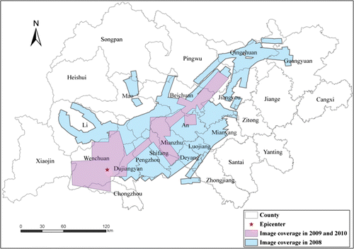
This study focuses on the area covered by the airborne optical and radar images acquired between 2008 and 2010 (see ). The flight area covers most of the 14 counties that were severely damaged by the Wenchuan Earthquake. These counties and cities include Beichuan County, Mianzhu City, Shifang City, Qingchuan County, Maoxian, Anxian, Dujiangyan City, Pingwu County, Pengzhou City, Lixian, Mianyang City, Jiangyou City, and Guangyuan City. This region is characterized by mountainous topography where the highest elevation is over 5000 m. Minjiang and Jian Rivers are the major rivers in this area. The monsoon climate brings large amounts of rainfall from June to September, and the mean annual precipitation is about 1500 mm.
Figure 1. Study areas and airborne remote sensing image coverage for the earthquake area.
3. Data acquisition
All remote sensing images used in the study were acquired from the Center for Earth Observation and Digital Earth (CEODE), CAS. CEODE is equipped with two airplanes with high-resolution optical and radar sensors onboard. CEODE also operates three ground stations in China that have capabilities of acquiring data from up to 13 satellites. Immediately after the Wenchuan Earthquake, CEODE set up missions to collect aerial and satellite images at different spatial resolutions from various sensors. In the following two years, airborne remote sensing images were acquired again in the severely hit areas to monitor the environment restoration and reconstruction. All images are described as follows in detail.
3.1. Images acquired in 2008
3.1.1. Satellite images
More than 400 images from 17 satellites were acquired for the earthquake reduction. Among those, 41 post-earthquake images at high and medium resolutions were acquired by satellites under CEODE. The CEODE also processed 105 scenes of archived images acquired before the earthquake. Meanwhile, with the help of other countries, many satellite images were acquired including Landsat-5/7, IKONOS, WorldView, and QuickBird from USA; SPOT-2/4/5 from France; COSMOS from Italy; TERRASAR-X from Germany; ASTER and ALOS from Japan; RADARSAT-1/2 from Canada; and EROS-B from Israel.
3.1.2. Airborne radar data acquisition
The multi-polarization (HH/HV and VH/VV) SAR system onboard CEODE aircraft has advantages of all-weather, all-time, flexible characteristics, and the capability to acquire SAR images at 0.5 m resolution. According to the requirements of the National Earthquake Relief Headquarter of the central government, the two aircrafts continuously flew over the damaged area and acquired aerial images at an average of 11 hours per day. From 14 May to 29 May, the planes flew 16 sorties and acquired 14.9TB of aerial SAR images at 0.5 m resolution, covering an imaging area of 39,000 km2.
3.1.3. Airborne optical image acquisition
Optical airborne images were acquired by an LH Systems ADS40 digital sensor from 15 May to 28 May 2008. The ADS40 camera is an advanced airborne camera with a large field of view (FOV) of 64 deg and an instantaneous field of view (IFOV) of 0.1 mrad. The spectral bands of the ADS40 include panchromatic, blue, green, red, and near infrared. The spatial resolution of these images ranges from 0.5 to 0.8 m depending on the flight altitude. About 5.3TB of optical images were acquired at 0.5 m resolution, covering an imaging area of 23,700 km2 with overlapping images. Orthorectification of all the airborne ADS40 images was conducted using the 25-m DEM data interpolated from 1:50,000 scale topographic maps.
3.2. Images acquired in 2009 and 2010
Images of strongly hit areas were acquired through airborne remote sensors in 2009 and 2010. Images acquired in these years share similar ground coverage areas. From 11 May to 4 June in 2009, 15 flights were conducted with an ADS80 digital sensor and 2.5TB optical images with around 0.5 m spatial resolution were acquired; eight flights were conducted with an SAR sensor and 3TB multiband images including X, C, and L were acquired. The ADS80 sensor is an updated version of the ADS40 sensor used in 2008. In April of 2010, 81 flights were conducted with an UltraCam-Xp (UCXP) digital sensor at a spatial resolution of about 0.4 m. Totally, 4589 images were acquired that covered approximately 7190 km2. The UCXP is a frame digital camera with a large FOV of 73 deg at cross track and 52 deg at along track. The spectral bands of the UCXP include panchromatic, blue, green, red, and near infrared. The spatial resolution of these images ranges from about 0.4–0.9 m depending on the flight altitude.
4. Monitoring and assessment of disaster and reconstruction
In 2008, our work focused on monitoring and assessment of the Wenchuan Earthquake in support of emergency rescue. Numerous achievements were obtained and published. Here we give a summarized review based on these results. In 2009 and 2010, environmental restoration and reconstruction in the severely hit areas were monitored and assessed utilizing airborne optical images acquired from 2008 to 2010. To illustrate changes representing environmental restoration and human settlement reconstruction, respectively, four areas have been selected and are discussed here including Tangjiashan Barrier Lake, original Beichuan County, Yingxiu, and new Beichuan County.
4.1. Monitoring and assessment of disaster in 2008
With optical and SAR images acquired in the damaged areas in Wenchuan, we explored the feasibilities of near-real-time risk monitoring and disaster evaluation of the Wenchuan Earthquake. Our scientists representing different groups conducted the disaster information extraction from six aspects, including: (1) the monitoring and assessment of the barrier lakes; (2) collapsed houses; (3) damaged roads; (4) destroyed farmland and forests; (5) secondary geological disasters; and (6) ecological habitat of the giant panda. The outputs were delivered to the national earthquake relief headquarters to assist post-earthquake recovery and mitigation decisions.
The Wenchuan Earthquake created numerous barrier lakes in mountainous areas. Fifty-one barrier lakes were monitored immediately after the acquisition of the high-resolution ADS40 airborne images. The distribution pattern is consistent with the direction of the Yingxiu-Beichuan fault zone within the study region. As part of the risk assessment, all barrier lakes were classified into three types. The dynamic change analysis of the oversized Tangjiashan Barrier Lake exhibited the evolution process (Liu et al. Citation2009).
Lei et al. (Citation2009) calculated the house collapse ratio via visual interpretation and image pattern recognition utilizing high-resolution optical images in the damaged 14 counties. It was found that the counties with higher collapse ratios are mostly distributed along the Beichuan-Yingxiu Fault Belt in the Longmen Mountain Faults. The house collapse ratio was higher in rural areas than in urban areas, because the design of the building structure in the countryside did not take earthquake resistance into consideration. For example, in downtown of Mianzhu City, the house collapse ratio was below 30% in towns that had high population, but it reached over 60% in the countryside around the downtown.
Huang et al. (Citation2009) monitored the blocked national and provincial roads in the hardest earthquake-hit areas and found that transportation network blockage and damage occurred in 808 segments, with a total length of 170.2 km, and occupied 29.66% of the total length of the state and provincial highways in the core disaster regions. The distribution of transportation network blockage and damage has obvious geographical characteristics.
In order to evaluate the damage in agricultural lands and natural environments, Ge et al. (Citation2009) acquired landscape damage information from 0.5 m-resolution aerial images acquired after the Wenchuan Earthquake and pre-disaster Landsat TM images, and then interpreted farmland damage information in earthquake-hit regions. This provided important support for estimating grain yield, rehabilitating, constructing the agricultural production, and restoring the ecological environment.
The major types of mass movement triggered by the Wenchuan Earthquake include landslides, avalanches, and debris flows. Zhang et al. (Citation2009) identified the areas of these secondary geological disasters, assessed the soil erosion degrees via interpretation of the ADS40 high-resolution aerial images, and found that in total area the secondary geological disaster was 2250 km2, covering about 8% of the total earthquake strongly hit area.
About 72% of the wild Giant Panda population and 68% of the Giant Panda's habitat are distributed in the Minshan and Qionglai mountain ranges (State Forestry Administration Citation2006). The Wenchuan Earthquake and its resulting geo-hazards (secondary hazards) caused a 65,584 ha loss of the ecological habitat of the giant panda, covering 5.92% of the total habitat (Ouyang et al. Citation2008).
4.2. Monitoring environmental restoration and reconstruction in 2009 and 2010
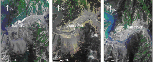
4.2.1. Tangjiashan Barrier Lake
shows land cover changes from 2008 to 2010 where the Tangjiashan Barrier Lake was once located. Being the largest barrier lake after the 8.0-magnitude Wenchuan Earthquake, it can be clearly seen from the image of 2008 that a large landslide blocked the Jian River and dramatically raised the water level. Its water level once rose to 723 m which was just 29 m below the lowest part of the barrier. In the image of 2009, the flow of the Jian River returned to normal indicating the barrier lake was successfully disposed by artificial dredging, natural overflow, and scouring. In the 2010 image, several roads had been constructed and transportation resumed. Also, land cover in the location had become greener compared with the previous two years, an indication of the progress of environmental restoration.
Figure 2. Airborne remote sensing images of Tangjiashan Barrier Lake acquired in 2008, 2009, and 2010, respectively (from left to right).
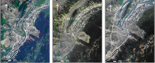
4.2.2. Original Beichuan County
mainly shows reconstruction progress and environmental restoration in the original Beichuan County from 2008 to 2010. As seen from the 2008 image, the county was nearly razed to the ground in the Wenchuan Earthquake. Heavy landslides from the western mountainous area covered a large amount of buildings in the southern region of the Jian River and created a large barrier lake. In the images of 2009 and 2010, this barrier lake had been disposed successfully. Several roads had been constructed in and around the county, while most of collapsed buildings were kept for the purpose of commemoration of the disaster. Meanwhile, parts of green lands destroyed in the disaster were gradually recovering. However, due to the slow pace of natural restoration of the environment, it will still take a long time before full recovery to its original status is achieved.
Figure 3. Airborne remote sensing images of original Beichuan County acquired in 2008, 2009, and 2010, respectively (from left to right).
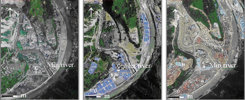
4.2.3. Counties of Yingxiu and new Beichuan
shows land cover changes of Yingxiu County from 2008 to 2010. Yingxu County is located in the south of Wencuan County. It was severely damaged in the Wenchuan Earthquake. Nearly, the entire county became debris after the disaster as shown in the image of 2008. After one year of reconstruction, most of the debris was cleared. Numerous transportable buildings with blue roofs shown in the 2009 image indicated that the whole county was under reconstruction. In the 2010 image, the reconstruction process had made speedy progress in various infrastructures. Roads, houses, and schools had been rebuilt and some projects had already been completed.
Figure 4. Airborne remote sensing images of Yingxiu County acquired in 2008, 2009, and 2010, respectively (from left to right).
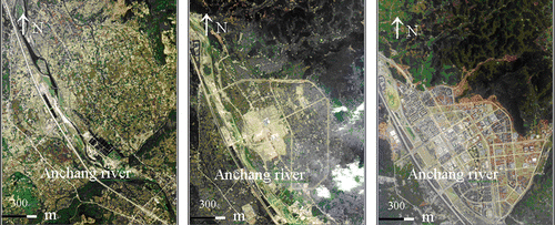
The original Beichuan County was located at the intersection of two faults and had been threatened by disasters like landslides for a long time period. The reconstruction of the County on its original location would be expensive and difficult. A new location about 2 km east of Anchang County was selected to rebuild the county as shown in . From the 2008 image, it can be seen that the new location had remained in a natural landscape. In the 2009 image, initial progress of the reconstruction was discernible as the outline of the new county became clear and transportation was largely restored. In the 2010 image, massive progress was made and a whole new county arose in the selected place. Along the Anchang River, an ecological corridor was built. Various infrastructures were built beside main roads. The new facilities were constructed utilizing modern technology and materials while still maintaining the cultural integrity of the Qiang community.
Figure 5. Airborne remote sensing images of new Beichuan County acquired in 2008, 2009, and 2010, respectively (from left to right).
5. Conclusion
This paper has shown the dynamic results of monitoring and assessing the Wenchuan Earthquake and the subsequent reconstruction of the afflicted regions utilizing remote sensing data from 2008 to 2010. All these results well demonstrate the importance and effectiveness of Earth observation in disaster mitigation and reconstruction. However, current work leaves open several questions and considerations for further study including: developing technologies of fast processing and analyzing of remote sensing images for emergency monitoring; enhancing the collaboration of multidisciplinary teams to form comprehensive analysis of multi-source technology system including obtaining and processing multi-level remote sensing data; and developing quantitative analyzing techniques for the comparison of multi-temporal high spatial resolution images.
Notes on contributors
Huadong Guo is a Professor and the Director-General of the Center for Earth Observation and Digital Earth, Chinese Academy of Sciences, Member of the CODATA Executive Committee. He is currently a Principal Scientist of National Basic Research Project on ‘Research on the Mechanism and Methodology for Sensitive Variables of Global Change Using Space Technologies,’ and was Principle Investigator for more than 20 key national projects or programs in China, also PI for over 10 international remote sensing projects. He has published over 200 papers and 12 books.
Liangyun Liu is a Research Professor at the Center for Earth Observation and Digital Earth, Chinese Academy of Sciences (CAS), and the Director of the Division of Optical Earth Observation. He received his Ph.D. degree in optics from Xi'an Institute of Optics and Precession Mechanics, CAS, in 2000. His research experience and interests are in fluorescence remote sensing, vegetation quantitatively remote sensing, and spatiotemporal analysis of remotely sensed data.
Liping Lei is a professor at the Center for Earth Observation and Digital Earth, Chinese Academy of Sciences. She received her Diploma degree in Geography from Peking University in China in 1983 and her PhD degree in Computer Information System from Iwate University in Japan in 1999. Her current research focuses on remote sensing, geographic information science and global change.
Yanhong Wu is an Assistant Professor at the Center for Earth Observation and Digital Earth, Chinese Academy of Sciences (CAS). She received her PhD in Physical Geography from the Institute of Geographic Sciences and Natural Resources Research, CAS, in 2008. Her current research interest is global change in the Tibetan Plateau and remote sensing applications.
Liwei Li is an Assistant Professor at the Center for Earth Observation and Digital Earth, Chinese Academy of Sciences (CAS). He received his Master degree and PhD both in Cartography and GIS from University of Wuhan in 2005 and the Institute of Remote Sensing Applications, CAS in 2008, respectively. He currently interests in the processing and applications of high spatial/spectral resolution remote sensing images.
Bing Zhang is a Professor and the Deputy Director of the Center for Earth Observation and Digital Earth, Chinese Academy of Sciences (CAS). He received his BS from Peking University, and MS and PhD from CAS. He specializes in hyperspectral remote sensing and has more than 14 years of experience in studying and graduate education in this field. His study interests include development of physics-based models and image processing software for the use of hyperspectral remote sensing data in solving problems in geology, hydrology, ecology, and botany.
Zhengli Zuo is a Senior Engineer at the Center for Earth Observation and Digital Earth (CEODE), Chinese Academy of Sciences, and the Director of the Division of Optical System Engineering of the Airborne Remote Sensing Center at CEODE. He received his bachelor degree from Wuhan Technical University of Surveying and Mapping in Aerophotography in 1987. His current research focuses on airborne remote sensing and airborne sensor.
Zhen Li is a Professor at the Center for Earth Observation and Digital Earth, Chinese Academy of Sciences (CAS). He received his BS degree in Photography and Remote Sensing from Wuhan Technical University of Surveying and Mapping in 1988 and PhD degrees in Natural Geography from CAS in 1998. He is the author of more than 50 journal papers and has written three book chapters. His current research interests include microwave remote sensing, global changing, and environment and disaster remote sensing.
Acknowledgements
The authors would like to thank all of the team members who participated in the Wenchuan Earthquake Disaster Reconstruction, Monitoring and Assessment Using Remote Sensing Technology. This research is supported by National Basic Research Program of China (973 Program, Nos. 2009CB723906, 2009CB723902) and National 863 Program (2009AA12Z102).
References
- Ajami , S. and Fattahi , M. 2009 . The role of earthquake information management systems (EIMSs) in reducing destruction: a comparative study of Japan, Turkey and Iran . Disaster Prevention and Management , 18 ( 2 ) : 150 – 161 .
- Ehrlich , D. 2009 . Identifying damage caused by the 2008 Wenchuan earthquake from VHR remote sensing data . International Journal of Digital Earth , 2 ( 4 ) : 309 – 326 .
- Ge , Y. 2009 . Image interpretation and statistical analysis of vegetation damage caused by the Wenchuan earthquake and related secondary disasters . Journal of Applied Remote Sensing , 3 : 031660
- Guo , H.D. 2010 . Understanding global natural disasters and the role of earth observation . International Journal of Digital Earth , 3 ( 3 ) : 221 – 230 .
- Guo , H.D. 2010 . Damage consequence chain mapping after the Wenchuan Earthquake using remotely sensed data . International Journal of Remote Sensing , 31 : 3427 – 3433 .
- Huang , X. , Wei , C. and Li , H. 2009 . Remote sensing analysis of the distribution and genetic mechanisms of transportation network damage caused by the Wenchuan Earthquake . Journal of Applied Remote Sensing , 3 : 031650
- Lei , L. 2009 . Assessment of the spatial variation of collapsed houses in the Wenchuan earthquake using aerial images . Journal of Applied Remote Sensing , 3 : 031670
- Liou , Y.A. , Kar , S.K. and Chang , L. 2010 . Use of high-resolution FORMOSAT-2 satellite images for post-earthquake disaster assessment: a study following the 12 May 2008 Wenchuan earthquake . International Journal of Remote Sensing , 31 : 3355 – 3368 .
- Liu , L. 2009 . Monitoring and assessment of the barrier lakes formed after Wenchuan Earthquake based onmulti-platform remote sensing . Journal of Applied Remote Sensing , 3 : 031665
- Ouyang , Z. , et al. 2008 . Impact assessment of Wenchuan Earthquake on ecosystems . Acta Ecologica Sinica , 28 12 , 5801 5809 in Chinese
- Pesaresi , M. , Gerhardinger , A. and Haag , F. 2007 . Rapid damage assessment of built-up structures using VHR satellite data in tsunami-affected areas . International Journal of Remote Sensing , 28 : 3013 – 3036 .
- State Forestry Administration , 2006 . The 3rd National Survey Report on Giant Panda in China . Beijing : Science Press
- Zhang , B. 2009 . Estimating soil erosion changes in the Wenchuan earthquake disaster area using geo-spatial information technology . Journal of Applied Remote Sensing , 3 : 031675
- Zhang , D. , 1993 . Preliminary study on visual interpretation marks of building damages caused by earthquakes on aerophograph . Earthquake , 2 , 26 30 in Chinese
- Zhu , B. , Wei , C. Zhang , Z. , 1998 . The quick extracting of earthquake disaster data by aerial remote sensing survey . Journal of Natural Disasters , 7 1 , 34 39 in Chinese
- Zhuang , J.Q. 2010 . Probability assessment of river blocking by debris flow associated with the Wenchuan Earthquake . International Journal of Remote Sensing , 31 : 3465 – 3478 .