Abstract
This paper introduces a scalable virtual learning environment of the Chinese University of Hong Kong; an explicitly geographical, immersive, and sharable 3D learning space with comprehensive social elements. It is characterized by multi-user collaborative modeling, group learning approaches of geo-collaboration, social space-oriented hierarchical avatars, and knowledge exchanging and sharing based on virtual geographic experiments. Applications for the purpose of public education and virtual geographic experiment, and indicated future works prove the possibility to offer a greater opportunity to foster interdisciplinary collaborations, revitalize teaching patterns and learning contents, improve learners' cognitive abilities to solve problems, and enhance their understanding of scientific concepts and processes.
1. Introduction
Virtual learning environments (VLE) (Dalgarno Citation2002, Pan et al. Citation2006, VLE Citation2010) are becoming widely approved and popular in the process of construction of digital earth, and are ideal study environments for ‘life-long’ learners and have the potential to change almost every aspect of everyday life, including daily communication, public education, training, and volunteered scientific collaboration (Goodchild Citation2007). This important trend can be summarized from the following aspects: (1) public education demand: more and more people are concerned about economizing the time of teaching staff, especially for those located far away from their schools. Both teachers and students are seeking innovative strategies to make sure that their learning is not confined to a particular building, or restricted to any single location or moment. Most students anticipate learning in a quick and non-threatening mode by experience in virtual environments instead of the traditional talk-and-chalk physical world. (2) The benefits of collaborative scientific discovery: to bridge the gap between the quantitative information contained in complex scientific experiments, and the human intuition for a true understanding of the phenomena in question, more people would like to participate in the virtual experiment activity in an open collaborative geographic platform, using computerized tools to visualize, investigate, and analyze a realistic three-dimensional (3D) world. In addition, researchers suggest physical and mental exercises that are difficult to carry out in the real world should first be performed many times within a virtual environment. (3) Social gaps can be shorter than physical distance: VLEs should also serve as a medium to break the walls inside our society, to overcome space, time, and performance demands. (4) Technology innovation: the technological breakthrough of virtual reality and mixed reality, especially with the rise in computing power of graphic card technology, high-performance computing, collaborative techniques, and changes in data licensing models, is rapidly facilitating social environments, enriching the public educational form and strategy of teaching and learning.
While significant progress has been made in 3D city modeling oriented to various geographical features and thematic domains (Dykes et al. Citation1999, Zlatanova et al. Citation2004, Van Oosterom et al. Citation2006, Goodchild et al. Citation2007, Zhu and Li Citation2008, Zhu and Hu Citation2010), and numerous solutions to the digital city are also available, there are still limited explorations of social spaces, such as multicultural environments, for extending our abilities to mix, match, and visualize 3D data in the Mirror World (Vincent Citation2008). Being different from web-based distance education, what VLEs highlight is more collaborative learning practices in which students can view themselves not only as passive recipients of knowledge but also as active information providers with a unique intensive educational experience (McBrien et al. Citation2009). In the sense of shared virtual worlds, the more surprising developments are coming from the impressive successes of Second Life (SecondLife Citation2010, Steven and Margarita Citation2010), Active worlds (Activeworlds Citation2010), and Forterra OLIVE (Forterra Citation2010), putting avatars into the 3D environment and extending their applications via their scripting languages, which have the potential to move how we share, visualize, and communicate geographic data to a new collaborative level. However, many such existing systems emphasize too much the photo-realistic visualization and user interaction with a closely defined immersive virtual environment, while ignoring the real 3D geographic representation of the physical world, and are reluctant to investigate how to apply the geographic process model to the geographical data for scientific virtual geographic experimentation. It is worthwhile mentioning that the open source OpenSimulator (or OpenSim) (OpenSim Citation2010) may provide a practical route to VLEs, along with a suitable standardization for interoperability and flexible scalable applications, which is also easier to import geographic data from a variety of sources to build the replicas of the real physical world to explore experimental simulations and scientific visualization.
Consequently, the VLE is looking forward to build an environment that is an explicitly geographical and sharable virtual learning space, which can offer a great opportunity to foster interdisciplinary communications and facilitate all kinds of volunteered learners to customize their study at their own pace, whether they are students or scientists (who from different physical locations can easily access the contents and participate in virtual lectures and/or discussions), integrated with immersive, collaborative, and extendable advantages, not only revitalizing teaching patterns and learning contents, but also helping to improve substantially learners' cognitive abilities to solve problems and enhance their understanding of scientific concepts and processes.
In this paper we want to contribute to this reformulated vision based on the OpenSim to develop an avatar-based, collaborative, volunteered, 3D immersive, and scalable VLE of the Chinese University of Hong Kong (CUHK). The remainder of this paper is organized as follows. The distributed system architecture of the VLE is addressed in Section 2. The key issues of construction of the VLEs are discussed in Section 3 for multi-users collaborative modeling. Section 4 introduces the social space-oriented hierarchical avatars and Section 5 discusses the scalable applications for the purpose of public education and scientific experiment. Finally, the conclusions and future work are presented in Section 6.
2. Distributed system architecture of virtual learning environments (VLEs)
In this paper, our work on a VLE is firstly defined as an avatar-based, explicitly geographical, immersive, and sharable 3D visual environment for learning and combining comprehensive social elements. Based on the client/server architecture of OpenSim, a distributed virtual learning architecture is developed with three basic components: (1) the construction of distributed geographic scenes oriented to a shared lifelike space for physically distant learners to meet, engage, and collaborate, (2) collaborative virtual geographic experiments integrating the geographic process models for improving geography education and geographic knowledge sharing, as well as (3) avatars-based social behavior cognition to help learners have an immersive individual experience, interactive communications, and purposeful task simulations.
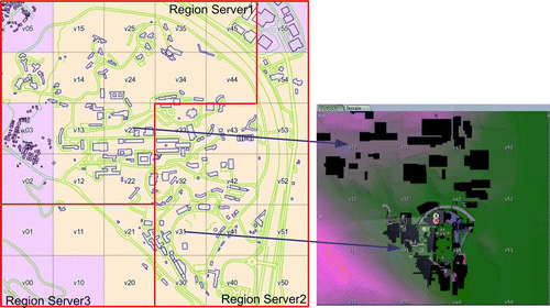
As shown in , the VLE server is deployed as a HTTP request and response application from a UserServerURI: http://cuhk.secondcampus.net.cn:8002/ with all the required components for virtual scene construction and application extensions. The grid manager server module provides a handy management for the user-account service, user's asset service, region grid control, and other services, which leverages the system of remote connectors and services. The region server is a feature for serving one or more scene regions, which communicates with the grid manager server and runs multiple region simulators on different distributed machines. The overall virtual learning scene based on the OpenSim server is thus known as the ‘grid’ in which the terrain domain is divided into regions of 256×256 meters. As shown in , the VLE of CUHK is divided into 36 regions by three distributed region servers for management of the data of DEM and 3D geo-objects, and each region has a unique ID for grid index such as v23, v31, etc. With the flexible extendable methods such as avatar robot plugins, OpenSim scripting languages, and region modules, OpenSim server offers the easiest possibility to revitalize teaching patterns and learning contents, improve learners' cognitive abilities to solve problems, and enhance their understanding of scientific concepts and processes, by integrating the storage and management of geographic process models and human behaviors. Based on the OpenSim viewer, the VLE client viewer is responsible for rendering the 3D scene as well as representing dynamic interactions such as virtual geographic experiments, social behavior simulation for extending participants’ dynamic applications. Via the VLE viewer, users in the VLE may modify the topography of land region, and each region can be operated as a work area related to the collaborative 3D modeling. When the models of each work area are collaboratively completed, dynamic applications such as virtual seminar for facilitating public education and virtual geographic experiments for identifying the geographic phenomenon (see Section 5) can also be implemented and are further combined to form the whole VLE.
Figure 1. The distributed system architecture of virtual learning environments.
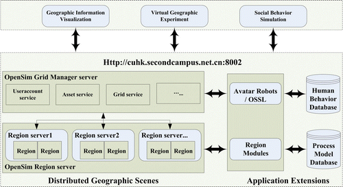
Figure 2. Regions of virtual CUHK and their top rendering map.
3. Multi-users collaborative 3D modeling
Traditional single-user 3D modeling based on sub-areas has shown its limitations such as time-consuming combination of all sub-workspaces, post-processing, and data inconsistency or data conflict needing repeated modification. Consequently, interactive collaborative modeling is necessary for user and creator to explore the VLE. Based on the common database clusters with the objects being edited and visual information on the viewing angles of the different users being known, the whole VLE is constructed by collaborative work in a distributed virtual environment to support object reconstruction with more than one modeler, as shown in the bottom of . All modelers can access this system from remote locations for co-building objects, modifying the virtual environment through synchronous or asynchronous cooperation, creating shared standard geo-models such as bridges, trees, and shared inventories and repositories of textures, and implementing interactive dynamic applications via multiple avatars toward a collaborative task. From , it was also found that a natural feeling of the viewing angles of other users is clearly helpful when discussing the design and shaping of objects. In addition, the user interface is designed to allow for a powerful learning experience and sharing common features in the 3D space, facilitating users to query information, developing 3D avatar-based communications, and carrying out the scientific experiments.
Figure 3. Construction of geographic scene with multi-users collaborative modeling.
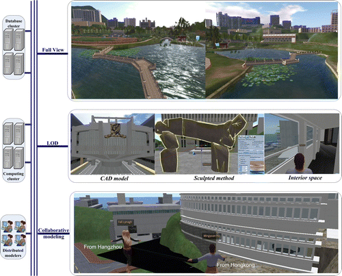
The 3D object can be either simple boundary representations such as planar faces and straight edges or complex volumetric representations with elaborate interior structures. Based on the OpenSim, a collaborative modeling approach oriented to multiple levels of details (LOD) of 3D content creation is provided, supporting the full view of the whole scene of the VLE from the simple bounding appearance to real 3D interior layouts, as shown in .
-
Primitive-based modeling: 3D models are represented or assembled by basic primitives such as box, cylinder, prism, sphere, torus, tube, and ring. The basic primitives by means of varying parameters including position, scale, rotation, shape, cut, hollow, etc., describe the location, shape, and appearance. In addition, primitive operations such as set union, intersection, and difference are easy to apply to the basic primitives to construct more complex 3D spatial bodies.
-
Integrated CAD model: Computer aided design (CAD) is mainly used for detailed engineering of 3D models with a high degree of accuracy. For the sake of interoperability, the use of existing CAD data has made it possible to reduce the amount of effort and time required to create 3D virtual world contents, maximize the value of geospatial data seamlessly, and improve the level of detail of 3D objects. For example, through format conversion, CAD model data such as *.3ds can be accessed as a special file in their own local coordinate system and be directly located in the VLE of the Chinese University with its absolute central coordinate attached to the point object.
-
Sculpted method: The sculpted method is a special type of complex surface modeling, allowing for the creation of smooth, curved surfaces like boats, sculptures or any other object from the absolute textures. The essential idea of the sculpted method for spatial objects’ surface representation is to design a series of connected sculpted prisms with their own control points to form a complex 3D shape. Each sculpted prism is a 3D mesh created from a texture array, of which each element corresponds to the information of a control point and the RGB values stored as x, y, and z coordinates, respectively.
4. Social space-oriented hierarchical avatars
In order to support flexible representation and analysis of social behavior at various application domains to users, hierarchical avatars are featured as three levels: user role identification, participant oriented to social interaction and perception, and smarter for human behavior simulation, as shown in .
Figure 4. Social space-oriented hierarchical avatars.
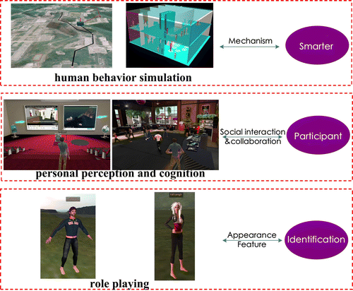
4.1. Identification
In the VLEs, avatars depict the identities of the online users who are observed people in real worlds, and have a permitted ability to play different roles in various social activities. People may choose or shape avatars by giving them natural characters with emotions and personality. By using the assigned avatar, users can walk around every corner of the virtual environment, no matter whether they have visited there before or not. Further, users are given the qualifications to join a virtual community, take part in a particular lecture and exchange ideas with their teacher in the virtual classroom, and during the whole course teachers and students are not confined to an appointed place by means of their avatars.
4.2. Oriented to personal social interaction and perception
In the VLE, there are many virtual communities divided by space, interests, culture, and other cognitive factors, based on which their own constitution, social, political, and economic structures in the virtual world are further formed. At this level, the avatars can be understood as active participants with the necessary abilities to achieve certain tasks in a specific domain environment/community, thus letting humans generate a feeling of ‘virtual reality’ of the real environment, further motivating the perception and understanding of the real geographic environment. Therefore, users may obtain a beneficial effect on perceptual and cognitive space via the 3D avatar, and feel immersive, making administrators more efficient and present as they do in the real world. Through acquisition, storage, conversion, and analysis of useful information in the VLE, avatars can assist human beings to understand the objective nature and patterns, distribution of locations, and changes or trends of various things, which contribute to human beings forming a conceptual world to describe and represent the objective world.
4.3. Oriented to human being's behavior simulation
The more attractive feature of an avatar lies in its ability to explore a human being's actual behavior and response to those spatial phenomena and geographic process whose occurrence is difficult to reproduce in the real world, or are difficult for people to perceive directly, especially for various natural hazards like earthquakes, landslides, floods, fires, tsunamis, volcanic eruptions, etc., which may injury many people and destroy property and infrastructures. Therefore, the experiences of avatars are of very important practical value when referring to specific issues, such as evacuation behavior simulation of a fire escape, the entity conduction in military exercises, etc. In the long run, the benefits of avatars for human behavior simulation are obvious in that they can assist human beings to carry out a variety of living activities, harm reduction, cost savings, and improvements in efficiency.
5. Scalable scientific collaborations in virtual learning environments
Since the VLE of CUHK is based on the open source OpenSim, interactive applications can easily be extended by the effective script engine such as LSL (LSL Citation2010), OSSL (OSSL Citation2010), and integration of the professional geographic process model. Typical application extensions for the purpose of public education and scientific experiment are discussed below.
5.1. Improving public education
People's cognition of public education is no longer constrained to the traditional face-to-face lecture formats. VLEs can really enable novel collaborative learning and educational patterns, and we may have an active platform of seminars, lectures, collaboration meetings, and free-form scholarly discussions by means of it. Anyone from anywhere could attend a lecture, informal group discussions or full-size international conferences in the VLEs, whether they are a student or a scientist.
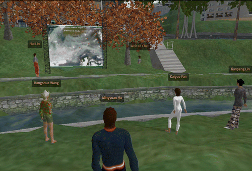
shows a demonstration of a regular weekly collaborative seminar in the virtual CUHK. Taking advantage of the essential internet components, remotely located participants in the seminar including PhD students, postdoctoral fellows, and professors carry out opinion exchanges easily but without traveling. The demonstration shows that VLEs can be a means of enhancing, motivating, and stimulating learners' understanding of certain events, especially those for which the traditional notion of instructional learning have proven inappropriate or difficult. This shift to virtual meetings can potentially enable users to become more confident in their ability to constructively interact with the VR elements, immersed in a quick and non-threatening learning and discussion mode in the virtual environments.
Figure 5. Flexible seminar form in a virtual learning environment: from different physical locations, participants can easily access the contents and participate in virtual lectures or discussions; participation is easy, free, and does not even require travel.
5.2. Oriented to a virtual geographic experiment
A virtual geographic experiment aims to establish and visualize geographic models to discover and verify geographic phenomena, processes, and changing mechanisms by calculation, simulation, visualization, interaction, and manipulation based on the computing data environment (Lin et al. Citation2009). It provides a new geography research and geographic knowledge application in collaborative ways to carry out geographic study on complex processes and geographic systems. It may correspond to geographic positioning field experiments, or indoor physical modeling experiments. In addition, it may also be some virtually constructed experiments based on specific geographic features, phenomena, and processes that are difficult to carry out as physical experiments in the real world, which may help learners facilitate the mental construction of 3D space, bridge the gap between the concrete world of nature and the abstract realm of concepts and models.
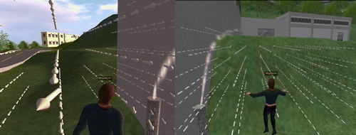
examines the smoke dispersion of air pollutants emitted from stationary point emission sources based on the measured wind vector field generated from the OpenSim system. Furthermore, learners could be guided to adjust the wind field data referenced to the historical meteorological data and the corresponding smoke dispersion experience would be presented in the VLEs. Such virtual geographic experiment activities provide learners with a more intuitive understanding of natural science and contribute to the promotion of essential emergency-decision skills.
Figure 6. Two views of smoke dispersion and their corresponding wind fields.
6. Conclusions and future work
The VLE of the CUHK holds scalable advantages that can be used as an effective aid in daily life, public education, and scientific research. (1) It allows for a powerful learning experience with an immersive, collaborative, and reusable communication environment, thus aiming to facilitate the process of teaching and learning. (2) It offers a more flexible and scientific potential that helps to discover the relations between human beings and natural phenomena, thus contributing to the understanding of the mental process construction of the human simulation system. (3) It promotes the next generation of scientific collaboration. For example, with the support of such an integrated platform of interactive and collaborative work and the geographic experimental environment provided by VLE, volunteers can also analyze the represented geographic phenomena and processes and carry out joint research, knowledge discovery, communication, and decision-making in its immersive way. (4) It permits an unlimited range of worlds that people can explore, ranging from factual to fantasy, experiencing the past, present, and future, then progressing ‘beyond reality’ trend prediction or understanding based on the relevant geographic knowledge.
Further research based on this work will be focused on the integration with the sensor network (De Longueville et al. Citation2010, Huang et al. Citation2010) and the geographic process model to build a smart digital earth environment by means of augmented reality of linking virtual spaces with the physical world to help identify human behavior features and geographic phenomenon related to the living environment.
Notes on contributors
Dr. Mingyuan Hu received the PhD in Photogrammetry and Remote Sensing from Wuhan University, China, in 2008, and now is a postdoctoral fellow of the Institute of Space and Earth Information Science, the Chinese University of Hong Kong. His research interests are Virtual Geographical Environments (VGEs), 3D City Modeling and Dynamic process simulation for geo-spatial cognition.
Prof. Hui Lin is now director of the Institute of Space and Earth Information and Science, Chinese University of Hong Kong. He was elected in 1995 as academician of the International Eurasian Academy of Sciences. His current research projects include Virtual Geographic Environments, Cloudy and Rainy Environmental Remote Sensing, Megalopolitan GIS, and Spatially Integrated Humanities and Social Science.
Prof. Bin Chen received the PhD in Computer Science and Technology from Peking University, China, in 2002. Currently, his main research interests include virtual geographic environments, geospatial distributed computing, and geospatial database.
Dr. Min Chen is now a postdoctoral fellow of the Institute of Space and Earth Information Science, the Chinese University of Hong Kong. Chen's research interests are Virtual Geographical Environments (VGEs) and Spatially Integrated Humanities and Social Science.
Weitao Che received the Master degree in Cartography and GIS from Nanjing Normal University, China, in 2009. Currently, his main research interests include virtual geographic environments, sensor networks, and geospatial database.
Dr. Fengru Huang received the PhD in Cartography and GIS from Peking University, China, in 2008. Currently, his main research interests include virtual geographic environments, sensor networks and geospatial database.
Acknowledgements
The work described in this paper is supported by the National High Technology Research and Development Program of China (973 program grant no. 2010CB731801), the National High Technology Research and Development Program of China (863 key program grant no. 2009AA122202), HKSAR RGC Project no. 447807, and the Research Fund of State Key Laboratory of Resources and Environmental Information System, Chinese Academy of Sciences. We also appreciate the detailed suggestions and comments from the Editor and the anonymous reviewers.
References
- Activeworlds , 2010 . Virtual worlds building platform [online]. Available from: http://www.activeworlds.com/ 3[Accessed February 2010] .
- Dalgarno , B. 2002 . The potential of 3D virtual learning environments: a constructivist analysis . Electronic Journal of Instructional Science and Technology , 5 : 3 – 26 .
- De Longueville , B. , et al. , 2010 . Digital earth's nervous system for crisis events: real-time sensor web enablement of volunteered geographic information . International Journal of Digital Earth , 1 18 (first published 11 May 2010)
- Dykes , J. , Moore , K. and Wood , J. 1999 . Virtual environments for student field work using network components . International Journal of Geographical Information Science , 13 : 397 – 416 .
- Forterra , 2010 . Online interactive virtual environment (OLIVE) [online]. Available from: http://www.forterrainc.com/ [Accessed February 2010] .
- Goodchild , M.F. 2007 . Citizens as sensors: the world of volunteered geography . GeoJournal , 69 : 211 – 221 .
- Goodchild , M.F. , Yuan , M. and Cova , T.J. 2007 . Towards a general theory of geographic representation in GIS . International Journal of Geographical Information Science , 21 : 239 – 260 .
- Huang , Z. , Fang , Y. and Pan , M. 2010 . Toward an integrated framework for geosensor grid . International Journal of Digital Earth , 3 : 207 – 216 .
- Lin , H. , Huang , F. and Lv , G. 2009 . Development of virtual geographic environments and the new initiative in experimental geography . Acta Geographica Sinica , 64 : 7 – 20 .
- LSL , 2010 . Linden scripting language [online]. Available from: http://www.wiki.secondlife.com/wiki/LSL_Portal [Accessed June 2010] .
- McBrien , J.L. , Jones , P. and Cheng , R. 2009 . Virtual spaces: employing a synchronous online classroom to facilitate student engagement in online learning . International Review of Research in Open and Distance Learning , 10 : 1 – 17 .
- OpenSim , 2010 . OpenSim project [online]. Available from: http://www.opensimulator.org [Accessed February 2010] .
- OSSL , 2010 . OSSL scripting language [online]. Available from: http://www.opensimulator.org/wiki/Scripting_Documentation [Accessed June 2010] .
- Pan , Z. 2006 . Virtual reality and mixed reality for virtual learning environments . Computers & Graphics , 30 : 20 – 28 .
- SecondLife , 2010 . Second life virtual community [online]. Available from: http://www.secondlife.com/ [Accessed February 2010] .
- Steven , W. and Margarita , P.G. , 2010 . 3D design and collaboration in massively multi-user virtual environments (MUVEs) [online] . In : D. Russell , Cases on collaboration in virtual learning environments: processes and interactions , 27 41 . Available from: http://www.igi-global.com/Gateway/ContentOwned/Chapters.aspx?TitleId=128 [Accessed May 2010] .
- Van Oosterom , P. 2006 . The core cadastral domain model. Computers . Environment and Urban Systems , 30 : 627 – 660 .
- Vincent , T.C. , 2008 . Empowering the 3D web-extension of your lives . In : H. Lin and M. Batty , Virtual geographic environments: an international conference on developments in visualization and virtual environments in geographic information science . Hong Kong : Science Press , 49 64 .
- VLE , 2010 . Virtual learning environment [online]. Available from: http://www.en.wikipedia.org/wiki/Virtual_learning_environment [Accessed May 2010] .
- Zhu , Q. and Hu , M.-Y. 2010 . Semantics-based 3D dynamic hierarchical house property model . International Journal of Geographical Information Science , 24 : 165 – 188 .
- Zhu , Q. and Li , Y. 2008 . Hierarchical lane-oriented 3D road-network model . International Journal of Geographical Information Science , 22 : 479 – 505 .
- Zlatanova , S. , Rahman , A.A. and Shi , W.Z. 2004 . Topological models and frameworks for 3D spatial objects . Computers & Geosciences , 30 : 419 – 428 .