Abstract
Sharing of scientific data can help scientific research to flourish and facilitate more widespread use of scientific data for the benefit of society. The Environmental and Ecological Science Data Center for West China (WestDC), sponsored by the National Natural Science Foundation of China (NSFC), aims to collect, manage, integrate, and disseminate environmental and ecological data from western China. It also aims to provide a long-term data service for multidisciplinary research within NSFC's “Environment and Ecology of West China Research Plan” (NSFC West Plan). An integrated platform has been developed by the WestDC, and this has the function of data sharing, acting as a knowledge repository. Major data sets developed by the WestDC include basic geographic data, the regionalization of global data set for China, scientific data for cold and arid regions in China, scientific data for the cryosphere in countries that neighbor China, data relating to the inland river basins in northwestern China, and data submitted by the NSFC West Plan projects. In compliance with the “full and open” data sharing policy, most data in the WestDC can be accessed online. Highlights include detailed data documentation, the integration of data with bibliographic knowledge, data publishing, and data reference.
1. Background
West China has one of the World's most diverse but fragile environments, with the Qinghai-Tibetan Plateau elevated in the south and high mountains, plateaus, deserts, and oases interspersed in the north. Its environmental status and evolution is always of great research interest. In 2001, the National Natural Science Foundation of China (NSFC) initialized a major research plan, the Environment and Ecology of West China Research Plan (hereafter referred to as the NSFC West Plan), which aims to improve the understanding of the evolution and future trends of the environment in western China and to detect the natural and human factors that have shaped the current environment in western China.
Establishing a data center was considered as a means of integrated study and has been assigned the highest priorities by the NSFC West Plan. Therefore, in 2006, the NSFC decided to establish the Environmental and Ecological Science Data Center for West China (hereafter referred to as WestDC). This was the first fully functioning data center for earth science developed by the NSFC. The objective of the data center is to systematically archive the data collected by individual projects of the NSFC West Plan and to provide a good data service for the integrated study of environmental and earth science in western China using these and other data sets (Li et al. Citation2008b).
Through efforts made over several years, the WestDC has achieved its objective as an operational data center for environmental and ecological data, and more broadly, for geoscientific data in western China. It has also accumulated experience in data stewardship and has been providing services that are believed to be useful for data sharing in China. This paper will introduce the objectives, institutional and technical constructions, main data sets, data stewardship, and services provided by the WestDC.
2. WestDC – a geoscientific and environmental data center
2.1. Why the WestDC?
Data sharing is very important in helping science research to flourish (Nelson Citation2009). “Research cannot flourish if data are not preserved and made accessible. All concerned must act accordingly,” as stated in the special issue of Nature on data sharing (Editorial, Citation2009). Data sharing is particularly important in China, as there is no strong culture of data sharing. Data have usually been retained by the scientists themselves rather than deposited in data centers. Fortunately, this situation has significantly improved in recent years. Data sharing has been emphasized by both policymakers and scientists, and several new data centers have been established in addition to the existing World Data Centers in China (Wang and Sun Citation2007). A nationwide scientific data-sharing program has been implemented by the Ministry of Science and Technology of China (Xu Citation2003), and a consensus has been reached that it is inappropriate to retain data as personal property (Huang and Guo Citation2002, Sun and Shi Citation2003, Ran et al. Citation2007).
It is one of the research sponsors’ responsibilities to ensure the integrity, accessibility, and stewardship of research data (NRC Citation2009). As the most important agency that supports basic research in China, the NSFC has decided to play an institutional role in data sharing in China. The WestDC can be viewed not only as the data hub for the NSFC West Plan (i.e. a technical infrastructure) but also as a permanent data center featuring distinctive regional representativeness and characteristic data sets. In this way, it will help in creating a data-rich environment and even a data-sharing culture, thereby acting as an institutional infrastructure of the NSFC for providing data services.
The immediate goals of the WestDC that focus on western China are as follows: (1) collecting and standardizing the existing environmental and ecological data; (2) providing full and open data access, stewardship, and services in line with the NSFC West Plan and in support of other environmental researchers; (3) formulating effective guidelines for data sharing; and (4) facilitating data submissions from the various projects covered by the NSFC West Plan and other organizations and individuals.
2.2. Data platforms in the WestDC
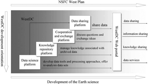
The technical infrastructure of the WestDC consists of four platforms: (1) data sharing; (2) a knowledge repository; (3) cooperation and exchange; and (4) data science (see ).
| 1. | Data sharing platform. This is a Web-based portal using the state-of-the-art computer technology. By reviewing existing geographic metadata standards, the ISO 19115 metadata profile has been adopted in the WestDC to serve the data-sharing requirement. Using the metadata, the portal enables user-friendly data display, navigation, and query, and offers both online and offline data services to users. To ensure the quality of metadata, a peer-review procedure is applied for metadata in the WestDC. Specific metadata are first edited by the data manager in the WestDC, and this information is then made available on a metadata interactive editing system created by GeoNetwork. The data authors and some experts are then invited to edit and correct the metadata online. It has been proven that metadata quality can be greatly improved with the input of expertise from two or more related experts. The metadata are then formally published. A feedback mechanism is also offered so that data users can comment on both the data and the associated metadata. The details of the technical architecture of the WestDC are introduced in Wang et al. (Citation2010). The data-sharing platform also provides applicable online map services, catalog services, and other Web services. | ||||
| 2. | The knowledge repository platform is an attempt to integrate the data with bibliographic knowledge. Literature-based knowledge relating to data collection, generation, processing, and application is generally not fully represented by the current metadata architecture. Compared with the itemized metadata structure, literature knowledge is usually presented in a concrete scientific context but is essentially useful for understanding the science behind the associated data. These kinds of knowledge can be brought to users only by linking the data and the relevant literature. The knowledge repository platform was built upon the Open Archival Information System (OAIS) reference model. A digital knowledge resource library (the core of the knowledge repository platform) was established to cover the environmental and ecological research literature of western China (Zhu et al. Citation2007, Nan et al. 2010). To avoid copyright issues, this library was developed in collaboration with the Lanzhou Branch of the Chinese National Science Library. WestDC has implemented connections between the metadata, data documents, and published papers by keyword query based on the Open Archives Initiative-Protocol for Metadata Harvesting (OAI-PMH) protocol. Such technically complicated connections are transparent to the end user. | ||||
| 3. | Cooperation and exchange platforms provide space to facilitate communication and the exchange of ideas using modern network tools, such as Web forums, mailing lists, and other current, advanced online conferencing approaches. | ||||
| 4. | The data science platform is designed as an advanced data processing and re-analysis component. It provides various data processing, provision, and assimilation tools and attempts to produce ready-to-use model data sets and high-resolution re-analysis data sets through data assimilation. | ||||
Figure 1. General scheme of the data platforms in the Environmental and Ecological Science Data Center for West China.
3. Main data sets
There are 331 data sets available in WestDC. The main data sets can be categorized as follows:
| 1. | Basic geographical data. These are defined as the fundamental data used in land surface hydrological, ecological, and other types of environmental analysis and modeling. These data were provided by research institutions and individual scientists or digitized from existing paper maps. Generally, they cover the entire land territory of China. The data include the following:
| ||||||||||||||||||||||||||||||||||||||||||||||||||||||||||
| 2. | Regionalization of global data sets for the land territory of China
| ||||||||||||||||||||||||||||||||||||||||||||||||||||||||||
| 3. | Scientific data for cold and arid regions in China. These refer to the Qinghai-Tibetan Plateau, the mountain cryosphere in western China, and arid regions (particularly the deserts). These data are usually derived from the results of scientific research in this region and are among the most innovative data in the WestDC. All the data were archived with detailed documentation.
| ||||||||||||||||||||||||||||||||||||||||||||||||||||||||||
| 4. | Scientific data for the cryosphere in countries neighboring China. These data include the following:
| ||||||||||||||||||||||||||||||||||||||||||||||||||||||||||
| 5. | Heihe River Basin data, a comprehensive database relating to the Heihe River Basin, which is the second largest inland river basin in the arid region of China. There is also a separate Web site known as the Digital Heihe River Basin (http://heihe.westgis.ac.cn) devoted specifically to sharing data relating to the Heihe River Basin. This shares the same database as the WestDC.
| ||||||||||||||||||||||||||||||||||||||||||||||||||||||||||
| 6. | Data submitted by NSFC West Plan projects. In total, 66 projects were conducted within the framework of the NSFC West Plan. Among them, 26 projects have submitted their data to the WestDC. After detailed documentation based on interactive discussions with the project principal investigator (PI) and co-PIs, specific data sets are then produced using the data submitted by one project or group of projects that have similar objectives. Of these data sets, some become immediately and freely available; others become publicly available after a 2-year privileged period. Some examples of these data sets are introduced below:
| ||||||||||||||||||||||||||||||||||||||||||||||||||||||||||
4. Data service
4.1. Data distribution
The WestDC complies with the “full and open” data sharing policy, and its data are accessible using two types of data services.
| 1. | Online data services. These are data sets that are accessible, together with their metadata and available data document(s), from the WestDC data portal. Since becoming operational in 2007, most of the data (725.4 GB, 90% of all data) in the WestDC have become downloadable, and online access keeps increasing: more than 7.0 terabytes of data have been downloaded as of September 2010. For instance, the subset of SPOT Vegetation NDVI for China has been downloaded more than 1540 times. The desert map of China has been downloaded more than 730 times. The number of registered users has increased rapidly to over 3800 as of September 2010. | ||||
| 2. | Offline data services. In accordance with Chinese laws and regulations, some data, such as large-scale topographic maps and high-resolution DEMs, cannot be placed online. In addition, some scientists and institutions who have submitted data demand that access to these data remain offline to retain full awareness of the use of their data. Therefore, a small set of data is offered offline for which a contract needs to be signed between the user and the WestDC. The requested data will then be sent to the user via DVD or other media. The total amount of data provided offline by the WestDC accounted for 2.13 terabytes as of September 2010. | ||||
4.2. Data documentation, reference, and publishing
Traditionally, the data themselves have not been cited in scientific publications. Insufficient and informal citation of data hinders the willingness of researchers to submit data because it adds little credit to their academic career as compared with formal papers in peer-reviewed journals (Parsons et al. Citation2010). To encourage increased submission of data sets, the WestDC has instituted the following measures:
| 1. | Data identification. The digital object identifier (DOI) makes unique data identification possible. This makes protection of intellectual property of data much easier and data publication more likely. The WestDC is among the first Chinese data centers to attempt the use of DOI for data identification. In cooperation with the Institute of Scientific and Technical Information of China, DOIs are applied to uniquely identify each data set within the WestDC. | ||||
| 2. | Data documentation. Two types of data documents exist. The first is peer-reviewed papers that are published in connection with the scientific data sets, and these are usually requested to be cited when using the data. The second type refers to data documents that describe the data sets, usually prepared by the data center. The latter is considered as gray literature and is very important for ensuring data usability (Parsons and Duerr Citation2005). As such, it is imperative that the full scope of the metadata be provided, and the data documentation should (a) clearly describe the data collection and production process; (b) clearly describe the properties of the data and the related operations; and (c) include references, citations, and other related information, including any scientific papers related to the data. Such a data document must be prepared by the data managers at WestDC in consultation with the scientists who contributed the data via an iterative dialog. Data documentation is also encouraged to be cited. | ||||
| 3. | Data publishing. Whereas data identification and data documentation enable the citation of data, it is desirable that the data be published as peer-reviewed papers in scientific journals. This level of review will significantly increase interest in the data sets, and scientists will be much more willing to share their data (Editorial, Citation2009). Data can be published in two ways. The first way would be to establish a data journal to publish scientific data, as is done by some other data centers. For example, EGU has published a new data journal, Earth System Science Data. The WestDC is also considering cooperating with some peer-reviewed scientific journals for data publication. The second way is to publish data on the data center's data portal; this is what most data centers, including the WestDC, are doing now, and by using DOIs, the data can be formally cited. Obviously, quality control (including proof-reading, correction, and peer review) is a prerequisite for publication. However, scientific journals are generally considered to be the best medium to foster data sharing among scientists. | ||||
| 4. | Data reference. The use of data should always be acknowledged. In the WestDC, the data reference information. In particular, the data contributors’ and producers’ names are emphasized in both metadata and data documents. A data user is required to make the necessary references to the data set(s) he or she uses, together with the document describing the data and related papers, in which the data contributors usually are major authors. In addition, users are encouraged to acknowledge the data center and this will add credibility to the WestDC. | ||||
4.3. Cooperation with other data centers
It is very important for the WestDC to cooperate with domestic and international data centers to provide a better data service for its users. It collaborates with other data centers in different ways.
WestDC has a close relationship with several world data centers (WDCs). The WDC for Glaciology and Geocryology in Lanzhou (http://wdcdgg.westgis.ac.cn) is affiliated with the same institute as the WestDC. The cryosphere data of western China are available at both data centers, with the WDC for Glaciology and Geocryology also providing information and data downloading services in English. The WestDC also collaborates closely with the WDC for Glaciology in Boulder, CO, which is maintained at the National Snow and Ice Data Center (NSIDC). An important data set of the WestDC, the subset of daily SMMR and SMM/I brightness temperature data for China from 1978, was derived from the DMSP Pathfinder Daily EASE-Grid brightness temperatures (Armstrong et al. Citation2010). Meanwhile, one of the flagship data sets in the WestDC, the Concise Chinese Glacier Inventory, contributes significantly to NSIDC's World Glacier Inventory. In NSIDC's Global Land Ice Measurements from Space (GLIMS) database, approximately 49% of the glacier records come from the Concise Chinese Glacier Inventory.
As for basic data, such as meteorological and hydrological data, WestDC archives these only for specific regions, for example typical inland river basins in northwestern China. Requests from users for these data for other regions are generally redirected to the data centers that host them. For example, meteorological data requests are redirected to the China Meteorological Data Sharing Service System.
In future, the WestDC should collaborate more broadly with other data centers. For example, several paleoclimate data sets (Tan et al. Citation2003) submitted by the NSFC West Plan project are also available at the WDC for Paleoclimatology.
Currently, all these cross-platform collaborations have been operated manually by the data managers at the different data centers. Potentially, these centers could interoperate using open geospatial standards (Nativi Citation2010, Percivall Citation2010). Because a standard metadata format is used at the WestDC and other data centers, it should be easy for data centers to harvest metadata from each other and develop further interoperable functions. In future, the creation of a data center league is also possible.
5. Summary and prospects
Indeed, data sharing is important. However, this sharing requires the institutional and technical infrastructure to facilitate it. We have to develop new types of data centers and introduce new ideas regarding data reference and data publishing, both within China and globally, to deal with the challenges that new technologies bring. The WestDC, as NSFC's first fully functioning data center, should pioneer this transition in China.
This paper introduces the objectives, institutional and technical construction, main data sets, and data stewardship and services of the WestDC. When referring to data stewardship, we include data archival, preservation, and publishing but also involve efforts to make the data accessible, including the provision of data documents, the linking of data to a digital literature library, the preparation of ready-to-use model data sets and re-analysis data sets, and the provision of a number of Web services. After several years, the WestDC has achieved its objectives in regard to the following aspects: the provision of a technically sound data portal that aids in facilitating data sharing, the development of a knowledge repository and online scientific collaboration tools, the collection of large amounts of innovative scientific data that are useful in environmental, ecological, and (more broadly) geoscientific research in western China, the facilitation of stable and supportive data users, the generation of useful experiences in data stewardship and services, and the rewarding of efforts in data referencing, publishing, and sharing.
Some weaknesses remain in the WestDC. The data sets are not yet fully integrated. For example, the lack of high-resolution and vegetation and soil maps that are compatible with international standards are still a bottleneck in geoscientific research for west China. The WestDC should collaborate with the scientists who are working in this field to make these data available – this is also an important objective of the NSFC West Plan. Other issues that should be prioritized include forming consortia with other data centers, data publishing, developing a bilingual Web site (Chinese and English), and strengthening the visibility of the data center.
Data sharing in China needs to be improved further. To create a data-rich environment in which data sharing and associated referencing are more common, many difficult issues remain to be overcome, and considerable actions need to be taken. The WestDC, as a representative data center of NSFC and a practitioner of data science, should be and is able to pioneer this effort. However, to grow from a data center of regional importance to one of global importance, the WestDC needs to make further efforts in collaborating more closely with scientists and scientific policymakers. “Data management should be woven into every course in science” (Editorial Citation2009). It is incumbent upon the entire scientific community to ensure that we foster the scientific data infrastructure required for scientific research to flourish and ultimately be a benefit to society, to China and the world.
Notes on contributors
Xin Li received his PhD degree from the Chinese Academy of Sciences (CAS) in 1998. He is currently a professor at the Cold and Arid Regions Environmental and Engineering Research Institute (CAREERI), CAS. He is also the director of the World Data Center for Glaciology and Geocryology at Lanzhou. His primary research interests include land data assimilation, application of remote sensing and GIS in hydrology and cryosphere science, and integrated watershed modeling.
Zhuotong Nan received his PhD degree in physical geography from the CAS in 2003. He was a post-doc research associate in the University of Pittsburgh, USA, in 2007–2009. Currently he holds an associate professor position at CAREERI. His research interests are related to data sharing, integrated modeling environment, and decision support systems for water resources management.
Guodong Cheng is currently the professor of CAREERI and the director of Lanzhou branch of CAS. He became an academician of CAS in 1993. He has been working for permafrost and related engineering problems for over 40 years and was the chief scientist of the Qinghai-Tibet railway research project. His current research interests are in hydrology and water resources in arid regions, and environment and engineering in cold regions.
Yongjian Ding received his MS degree in physical geography from CAS in 1987. He is currently the professor, doctoral advisor, and vice director of CAREERI. His research interests include glacier and periglacial environment, hydrology and water resources, and hydrogeology and engineering geology.
Lizong Wu received his PhD degree in remote sensing and GIS from CAS in 2010. Currently he holds an associate professor at CAREERI. His research interests are related to data sharing, glacier inventory, and glacial lake outburst flood.
Liangxu Wang received his MS degree in remote sensing and GIS from the CAS in 2005. Currently he holds an assistant professor at CAREERI. His research interests are related to scientific data sharing, land data assimilation, and high performance computing in scientific research.
Jian Wang received his PhD degree in remote sensing and GIS from the CAS in 2004. He is currently a professor at CAREERI. His research interests are related to remote sensing of snow and ice, hydrology of cold region, and integrated research of cryosphere and climate change.
Youhua Ran received the BS degree from the CAS in 2008. His main research interests are the application of the remote sensing and GIS in ecosystems analysis and modeling; land cover, plant function types and permafrost mapping; spatiotemporal analysis of remotely sensed data.
Hongxing Li is currently a PhD student of the CAS. Her research interest is related to snow pollution research by remote sensing.
Xiaoduo Pan is currently a PhD student of the CAS. Her current research interests are development of atmospheric forcing data for land surface model and downscaling methods.
Zhongming Zhu is a research scientist, the head of information technology department of the Scientific Information Center for Resources and Environment, CAS. His research interests include digital information environment and metadata applications, digital objects and repositories, knowledge management in academic and research institutions, and application of semantic web technologies to information integration.
Acknowledgements
This work is financially supported by the NSFC (National Science Foundation of China) (grant number: 40925004) and the Chinese Academy of Sciences Action Plan for West Development Project “Watershed Allied Telemetry Experimental Research (WATER)” (KZCX2-XB2-09). We thank the editor and the anonymous reviewers for their helpful and constructive comments on the manuscript.
Related Research Data
References
- Armstrong , R.L. 2010 . DMSP SSM/I Pathfinder Daily EASE-Grid brightness temperatures , Boulder , CO : National Snow and Ice Data Center. Digital media .
- Chai , H.X. , et al. , 2009 . Digital regionalization of geomorphology in Xinjiang . Journal of Geographical Sciences , 19 ( 5 ), 600 – 614 . doi: 10.1007/s11442-009-0600-4 .
- Che , T. 2008 . Snow depth derived from passive microwave remote sensing data in China . Annals of Glaciology , 49 : 145 – 154 .
- Editorial Board of Vegetation Map of China, Chinese Academy of Sciences , 2001 . Vegetation atlas of China (1:1,000,000) . Beijing : Science Press .
- Editorial , 2009 . Data's shameful neglect . Nature , 461 ( 7261 ), 145 – 145 . doi: 10.1038/461145a .
- He , L.H. , Jiang , N. and Shi , J.J. 2005 . On the design of China lake database . Modern Surveying and Mapping , 28 ( 5 ) : 3 – 5 .
- Hu , Y.Q. and Gao , Y.X. 1994 . Some new understandings of processes at the land surface in arid area from the HEIFE . ACTA Meteorologica Sinica , 52 ( 3 ) : 285 – 296 .
- Huang , D.C. and Guo , Z.Y. 2002 . Study on the management of scientific data sharing , Beijing : China Science and Technology Press. 389 pp .
- Jin , R. , Li , X. , and Che , T. , 2009 . A decision tree algorithm for surface soil freeze/thaw classification over China using SSM/I brightness temperature . Remote Sensing of Environment , 113 ( 12 ), 2651 – 2660 . doi: 10.1016/j.rse.2009.08.003 .
- Li , X. 2003 . Modeling Chinese cryospheric change by using GIS technology . Cold Regions Science and Technology , 36 ( 1–3 ) : 1 – 9 .
- Li , X. 2007 . Development of a Chinese land data assimilation system: Its progress and prospects . Progress in Natural Science , 17 ( 8 ) : 881 – 892 .
- Li , X. et al. 2008a . Cryospheric change in China . Global and Planetary Change , 62 ( 3–4 ), 210 – 218 . doi: 10.1016/j.gloplacha.2008.02.001 .
- Li , X. 2008b . Environmental and ecological science data center for west China: Integration and sharing of environmental and ecological data . Advances in Earth Science , 23 ( 6 ) : 628 – 637 .
- Li , X. et al. 2009 . Watershed allied telemetry experimental research . Journal of Geophysical Research , 114, D22103. doi: 10.1029/2008JD011590 .
- Liu , J.Y. et al. 2003 . Study on spatial pattern of land-use change in China during 1995–2000 . Science in China Series D-earth Sciences , 46 ( 4 ), 373 – 384 +Plate III .
- Liu , J.Y. 2005 . Spatial and temporal patterns of China's cropland during 1990–2000: An analysis based on Landsat TM data . Remote Sensing of Environment , 98 ( 4 ) : 442 – 456 .
- Nan , Z.T. , et al. , 2010 . Experiences of knowledge integration from the environmental and ecological science data center for west China . China Science & Techonology Resources Review , 42 ( 5 ), 15 – 21 . In Chinese
- Nativi , S. , 2010 . The implementation of international geospatial standards for earth and space sciences . International Journal of Digital Earth , 3 (Suppl. 1) , 2 – 13 . doi: 10.1080/17538941003764412 .
- Nelson , B. , 2009 . Data sharing: Empty archives . Nature , 461 ( 7261 ), 160 – 163 . doi: 10.1038/461160a .
- NRC , 2009 . Ensuring the integrity, accessibility, and stewardship of research data in the digital age . Washington , D.C : National Academies Press . 152 pp.
- Parsons , M.A. and Duerr , R. 2005 . Designating user communities for scientific data: Challenges and solutions . Data Science Journal , 4 : 31 – 38 .
- Parsons , M.A. , Duerr , R. , and Minster , J.-B. , 2010 . Data citation and peer review . EOS , 91 ( 34 ), 297 – 298 . doi: 10.1029/2010EO340001 .
- Percivall , G. , 2010 . The application of open standards to enhance the interoperability of geoscience information . International Journal of Digital Earth , 3 ( Suppl. 1 ), 14 – 30 . doi: 10.1080/17538941003792751 .
- Qiu , G.Q. et al. 2000 . The map of geocryological regionalization and classification in China . Beijing : Science Press . ( In Chinese )
- Ran , Y.H. , Li , X. and Lu , L. 2009 . China land cover classification at 1 km spatial resolution based on a multi-source data fusion approach . Advances in Earth Science , 24 ( 2 ) : 192 – 203 .
- Ran , Y.H. , Li , X. , and Lu , L. , 2010 . Evaluation of four remote sensing based land cover products over China . International Journal of Remote Sensing , 31 ( 2 ), 391 – 401 . doi: 10.1080/01431160902893451 .
- Ran , Y.H. , Li , X. and Wang , J. 2007 . The current key problems and potential solutions for geosciences data sharing in china . Data Science Journal , 6 ( Supp l ) : S250 – S254 .
- Shi , X.Z. et al. 2006 . Cross-reference system for translating between genetic soil classification of china and soil taxonomy . Soil Science Society of America Journal , 70 ( 1 ), 78 – 83 . doi: 10.2136/sssaj2004.0318 .
- Shi , Y.F. , 2005 . Concise Chinese glacier inventory . Shanghai : Shanghai Popular Science Press . 194 pp . (In Chinese)
- Sun J.L. Shi H.Z. 2003 Building up a scientific data sharing network for the Earth system science in China China Basic Science 1 75 81
- Tan , M. et al. 2003 . Cyclic rapid warming on centennial-scale revealed by a 2650-year stalagmite record of warm season temperature . Geophysical Research Letters , 30 ( 12 ), 1617. doi: 10.1029/2003GL017352.
- Tao , Z.H. , Zuo , H.C. and Hu , Y.Q. 1994 . HEIFE data base (HDB) . Plateau Meteorology , 13 ( 3 ) : 369 – 376 .
- Wang , J.H. , et al. , ( submitted ). A large-scale (1:100,000) desert map of China . Journal of Arid Environments .
- Wang , J.L. and Sun , J.L. , 2007 . Development of China WDC systems for data sharing . China Basic Science , ( 2 ), 36 – 40 . In Chinese
- Wang , T. , Wang , N.L. , and Li , S.X. , 2006 . Map of the glaciers, frozen ground and desert in China, 1:4,000,000 . Beijing : Chinese Map Press . (In Chinese)
- Wang , L.X. et al. 2010 . Application of open source technologies in geoscientific data centers . China Science & Technology Resources Review , 42 ( 3 ), 17 – 23 . (In Chinese)
- Wu , L.Z. and Li , X. , 2004 . China glacier information system . Beijing : Ocean Press of China . 135 pp . (In Chinese)
- Xu , G.H. , 2003 . Implement the scientific data sharing program and enhance the national science and technology competitiveness . China Basic Science , ( 1 ), 5 – 9 . In Chinese
- Zhang , S.Q. , 2002 . Brief introduction of the wetland science database of China . Scientia Geographica Sinica , 22 ( 2 ), 189 – 189 . (In Chinese)
- Zhu , Z.M. et al. 2007 . A Dspace-based sharing enviromental and ecological knowledge space . Library and Information Service , 51 ( 4 ), 71 – 74 , 108. (In Chinese)