Abstract
The purpose of this paper is to contribute to the definition of a European perspective on Digital Earth (DE), identify some actions that can contribute to raise the awareness of DE in the European context and thus strengthen the European contribution to the International Society for Digital Earth (ISDE). The paper identifies opportunities and synergies with the current policy priorities in Europe (Europe 2020, Innovation Union and Digital Agenda) and highlights a number of key areas to advance the development of DE from a European perspective: (1) integrating scientific research into DE; (2) exploiting the Observation Web with human-centred sensing; and (3) governance, including the establishment of stronger linkages across the European landscape of funding streams and initiatives. The paper is offered also as a contribution to the development of this new vision of DE to be presented at the next International DE Conference in Perth, Australia, in August 2011. The global recognition of this new vision will then reinforce the European component and build a positive feedback loop for the further implementation of DE across the globe.
1. Introduction
The purpose of this paper is to contribute to the definition of a European perspective on Digital Earth (DE), identify some actions that can contribute to raise the awareness of DE in the European context and thus strengthen the European contribution to the International Society for Digital Earth (ISDE). The paper builds on a meeting of the European members of the ISDE Executive Committee and a few other experts held at the Joint Research Centre (JRC) of the European Commission on 14–15th January 2010, and feedback received during the DE Summit held in Nessebar in June 2010.
The initial vision of DE was articulated by Al Gore, the vice-President of the USA, in 1998, as a multi-resolution, three-dimensional representation of the planet that would make it possible to find, visualise and make sense of vast amounts of geo-referenced information on the physical and social environment. Such a system would allow users to navigate through space and time, access to historical data as well as future predictions based for example on environmental models, and support access and use by scientists, policy-makers and children alike (Gore 1998).
The first International Symposium on DE was held in Beijing in 1999, hosted by the Chinese Academy of Science. The resulting Beijing declaration addressed the importance of Digital Earth in achieving global sustainable development and recommended that:
| 1. | Digital Earth be promoted by scientific, educational and technological communities, industry, governments, as well as regional and international organisations; | ||||
| 2. | While implementing the Digital Earth, priority be given to solving problems in environmental protection, disaster management, natural resource conservation and sustainable economic and social development as well as improving the quality of life of the humankind; and | ||||
| 3. | Digital Earth be created in a way that also contributes to the exploration of, and scientific research on, global issues and the Earth system (ISDE, Citation1999). | ||||
Following the successful Symposia held in 2001 (Canada), 2003 (Czech Republic) and 2005 (Japan), the ISDE was established in 2006 as a non-political, non-governmental and not-for-profit international organisation initiated by the Chinese Academy of Sciences (CAS) with the aim to promote international cooperation of the Digital Earth vision and enable Digital Earth technologies to play key roles in, inter alia, economic and socially sustainable development, to promote information technology and to reduce the digital gap.
The ISDE has been very successful in promoting the concept of DE through its bi-annual symposia and summits, and providing an outlet for academic debate through its International Journal of Digital Earth (IJDE). Developments such as Digital Asia (Fukui Citation2009), Virtual Australia (Woodgate and Coppa Citation2008), Digital Earth Prototype system: DEPS/CAS (Guo et al. Citation2009) and the establishment in 2007 of the Center for Earth Observation and Digital Earth (CEODE) by the Chinese Academy of Sciences indicate the vibrancy of the DE concept in Asia.
There are similar developments in the USA through the e-government initiative,Footnote1 the continued development of the National Spatial Data InfrastructureFootnote2 and the establishment in 2005 of the US Group on Earth Observation (USGEO Citation2005), with the vision of enabling a healthy public, economy and planet through an integrated comprehensive and sustained Earth observation system. The USGEO coordinates the US contribution to the development of the Global Earth Observation System of Systems (GEOSS).Footnote3
In Europe, the term Digital Earth is rarely used but there are many developments that strongly relate to it. At the political level, the European Commission launched in 2010 the Europe 2020 Strategy (European Commission [EC] 2010a) with the aim to achieve innovation-led, sustainable and socially inclusive growth. Research and innovation are central to the strategy not only to respond to the economic crisis of 2008–2009, but also to address the grand challenges facing Europe: aging population, international competitiveness and the imperative to move to a low-carbon paradigm. Seven flagship initiatives give substance to the strategy, addressing innovation, youth and the labour market, digital agenda, resource efficiency, industrial policy in the global context, skills and jobs, and social and territorial cohesion, respectively. Among them, the initiatives on Innovation Union (EC Citation2010b), and the Digital Agenda (EC Citation2010c) are particularly pertinent to this paper. The Innovation Union initiative places research, innovation and job-creation, particularly in small and medium enterprises at the heart of achieving the Europe 2020 objectives, and argues strongly for increased access and use of information and communication technology (ICT) based research infrastructures. This is further addressed by the Digital Agenda initiative, which identifies ICT for the environment as a critical area to deliver environmental, social and innovation-led growth objectives.
Whilst these initiatives provide a conducive political environment in Europe in which to embed the vision of DE, important developments are the implementation of the Infrastructure for Spatial Information in Europe,Footnote4 and the Global Monitoring for Environment and SecurityFootnote5 initiative, progress in the deployment of the Galileo positioning system, and the strong participation of Europe in the implementation of GEOSS.
At a global level, in addition to these government-led initiatives, a key role has been played by the private sector. In particular, Google and Microsoft have made the experience of DE familiar to hundreds of millions of users worldwide through their geo-browsers. Not only have users become familiar with the concept and practice of searching for information geographically and having it displayed on the globe, but crucially, the publication of the Application Programming Interfaces (API) has made it possible for users to become also producers of geographic information and contributors in the development of Digital Earth.
Notwithstanding these important developments, the current reality has grown up largely through the piecemeal exploitation of new technology. There has been a lack of holistic thinking about what benefits Digital Earth can offer and how best to exploit DE and extend it – the ‘why’ rather than the ‘what’. For example, we live in a world where half of its population live on under $2.50 per day and a billion children live in absolute poverty; where Africa accounts for 90% of the million of malarial deaths each year; where some 1.1 billion people in developing countries have inadequate access to water and 2.6 billion lack basic sanitation; where natural disasters like the tsunami triggered off Banda Ache killed 250,000 people; and where human-induced environmental stress is now widespread, whether it is manifested in the deforestation of the Amazon Basin or the progressive disappearance of wild areas and the extinction of species. The crux of all this is that these problems and many others do not impact simply on one small area of one country: when man-made disasters like Chernobyl or natural ones like hurricanes occur, their effects spread across nations and many communities.
We could see Digital Earth at its simplest as a global infrastructure enabling us to tackle some of these grand challenges. Through it, we should be able to facilitate collective and timely action. But it is much more than a ‘taken for granted’ plumbing system. At its best, Digital Earth should be an educational tool as well as a medium through which science and the use of evidence facilitates greater understanding of natural processes and the human condition. It can be a metaphor for human collaboration.
Central to the ubiquity of DE is that location (or geography) matters – problems are often first manifested geographically. Where things occur often determines their effects, the administrative structures to tackle problems are organised geographically and data from different sources can only be integrated using location as the linkage key.
Yet, we are not naive enough to believe that DE only brings benefits. Like nuclear fission, it could be used for many purposes which are contrary to what we hold important – it could destroy the concept of privacy, be used for terrorist purposes and be used to support decision-making which puts inexperienced communities at a disadvantage. Getting Digital Earth ‘right’ is therefore imperative and requires moral as well as technological and scientific inputs.
For these reasons, we see the need to engage across the public and private sectors, across the geosciences and social sciences and internationally in holistic discussions about what the nature of DE should be, how best we can use and develop it to good ends and how we can influence – for we cannot control – those developments.
The remainder of this paper is organised as follows: Section 2 reviews the perceived Strengths, Weaknesses, Opportunities and Threats (SWOT) of the vision of DE from a European perspective. Section 3 identifies some key topics of European interest not currently addressed in DE and Section 4 identifies the next steps to advance the European contribution to DE.
2. The vision of DE: a SWOT analysis
An analysis of SWOT helps to identify the DE state of play. Below is an initial list of points emerging from the discussions held during the workshop in Ispra and the DE summit in Nessebar.
2.1. Strengths
| • | Digital Earth is a very useful metaphor, easy to understand and provides a powerful way to convey a concept. | ||||
| • | DE displays some of the characteristics of ‘magic concepts’ (Pollit and Hupe Citation2009), like governance, which have an overwhelmingly positive connotation, can advertise, focus and legitimise certain ways of looking at the world, and help mobilise resources and political support. | ||||
| • | DE has a global dimension, inclusive of multiple applications and themes, and potentially embracing all mankind as the stakeholder. | ||||
| • | DE has a strong political backing since the beginning, particularly in the USA and China. | ||||
| • | DE has a strong technological component, harnessing developments in Internet technologies, data availability and visualisation methods among others. | ||||
| • | DE provides a flexible framework to adapt to evolving technologies, such as sensor networks and smartphones. | ||||
2.2. Weaknesses
| • | DE encapsulates many different concepts. It is sometimes presented as an information system or as an infrastructure to visualise and access geo-information, a virtual model of the Earth (or parts of it), or as an approach to explore global issues and the Earth system. | ||||
| • | DE has uneven visibility in different regions of the world. For example, it is a term rarely used in Europe, which then needs to compete with other related concepts, policies and priorities in the political landscape. | ||||
| • | There is some ambiguity on the nature of the DE vision: political vs. academic vs. a technological initiative and the main target audience: policy-makers and planners vs. scientific community or the general public. | ||||
| • | The vision has an unclear research focus, which may reduce interest in the scientific community. | ||||
| • | The relationships and added value of DE in relation to other initiatives, such as GEOSS and Spatial Data Infrastructures (SDIs) at different levels are not clear. | ||||
| • | The original DE vision does not properly reflect changes in society including the major role of the private sector (Google, Microsoft) and the emergence of social networks at the global level. | ||||
| • | Because of the uncertainties above, it is difficult to communicate clearly what DE is and how it will be put into practice. | ||||
| • | This difficulty in communicating the concept makes it harder to maintain links and collaborations with other initiatives such as GEOSS, and develops a DE community with active members from different disciplines in Europe to complement the active support of the Chinese Academy of Science. | ||||
2.3. Opportunities
| • | The increased availability of digital content from both public and private sectors, including that provided by the general public [e.g. volunteered geographic information (Goodchild Citation2007)], supports the vision of DE. | ||||
| • | Developments in technology and policy foster increased data access and sharing. | ||||
| • | The existence of the ISDE with 10 years of history, strong political backing and the support of the Chinese Academy of Science provides a platform for achieving the vision. | ||||
| • | Increasing profile of DE within the scientific community through symposia and the inclusion of IJDE in the scientific citation index. | ||||
| • | Increasing recognition of the need to build bridges across different related initiatives, as witnessed by the membership of the ISDE in the Group on Earth Observations (GEO). | ||||
| • | Multiple research and government funding opportunities available to develop components and applications of DE. | ||||
| • | Profiling DE as a central vision space where ‘Geo-Imagineers’ can think out-of-the-box: where they can extend and modify the vision of DE by incorporating innovative ideas and cutting-edge technologies, combining disciplines, and ultimately feeding new ideas and requirements into research projects and more practically oriented initiatives. | ||||
2.4. Threats
| • | There is no shared ownership over the vision of DE, and the leadership in relevant supra-national and global initiatives does not always recognise the importance and power of the DE vision as a mechanism to advance the realisation of DE. As a result, initiatives are sometimes competing for resources rather than exploiting synergies. | ||||
| • | The private sector's own vision and interpretation of DE, and the resources at its disposal, may overshadow and make irrelevant governmental or academic efforts in this area. | ||||
| • | Because of the success of the private sector's mass market applications, the need for research and development in the area of DE may become less evident to the funders of public sector research programmes. | ||||
3. Topics of European interest
An enhanced contribution from Europe to the development of DE cannot of course address all the issues identified above. It should, however, work on some of these aspects, building on the opportunities and strengths and contribute towards reducing perceived weaknesses or potential threats. In some instances, it may not even be desirable or possible to resolve an issue identified. For example, we may have to accept that there will not be one DE but many reflecting the priorities of different stakeholders. They should however be connected or represent different views of the same underlying information resource base. With these considerations in mind, we have identified three main topics on which we feel Europe has the opportunity to make a significant contribution.
3.1. Integration of scientific research into DE
Digital Earth is often articulated in terms of the contribution it can make to science (see for example recommendation 3 of the 1999 Beijing Declaration in Section 1 of this paper). It can however also be argued as a framework for undertaking the research necessary to achieve DE. Both perspectives are important and deserve to be more clearly integrated in DE.
In respect to the former, we would emphasise the role that DE can play in supporting the integration of environmental and social sciences models at multiple scales, addressing issues, such as global change, climate change, land use change and environmental degradation, sea level rises, natural resource depletion and the impacts of these phenomena on society and the economy at global, continental and local levels. This has been recognised by the International Council for Science (ICSU) which argued that one of the most fundamental challenges facing humanity at the beginning of the twenty-first century is to respond effectively to the global changes that are increasing pressure on the environment and on human society. This priority is articulated by the ICSU as follows:
Over the next decade the global scientific community must take on the challenge of delivering to society the knowledge and information necessary to assess the risks humanity is facing from global change and to understand how society can effectively mitigate dangerous changes and cope with the change that we cannot manage. We refer to this field as ‘global sustainability research’. (ICSU Citation2010, p. 6)
ICSU identified five scientific priorities, or Grand Challenges, in global sustainability research through a broad consultation involving over 1000 scientists from 85 countries in 2009–2010. These Grand Challenges include
| 1. | Developing the observation systems needed to manage global and regional environmental change; | ||||
| 2. | Improving the usefulness of forecasts of future environmental conditions and their consequences for people; | ||||
| 3. | Recognizing key thresholds or non-linear changes to improve our ability to anticipate, recognise, avoid and adapt to abrupt global environmental change; | ||||
| 4. | Determining what institutional, economic and behavioural responses can enable effective steps toward global sustainability; | ||||
| 5. | Encouraging innovation (coupled with sound mechanisms for evaluation) in developing technological, policy and social responses to achieve global sustainability. | ||||
DE can be the framework addressing these five Grand Challenges. DE can underpin the global sustainability research, whilst contributing at the same time to innovation and sustainable economic growth, which from a European perspective are the current key priorities.
Looking at the reverse side, i.e. the research issues that need to be addressed to implement the vision of DE, we would emphasise issues addressing (1) information fusion and integration (multi source and heterogeneous, multi-disciplinary, multi-temporal, multi-scale, multi-media and multi-lingual); (2) space-time analysis and modelling (i.e. universal elements and language for dynamic modelling, algebra of space-time change); (3) intelligent descriptions (automatic, user driven) of data, services, processes, models, searching and filtering; (4) visualisation of abstract concepts in space (linking for example to the cultural heritage topic identified above); (5) computational infrastructures to implement the vision of DE (architecture, data structures, indexing, interfaces); and (6) trust, reputation and quality models for contributed information and services [for a fuller description of these topics see Craglia et al. (Citation2008)].
3.2. Citizens' involvement and the Observation Web
DE involves multiple stakeholders. While the roles of environmental and social scientists, technologists and decision-makers are widely acknowledged, those of individual (private) citizens in the development, use, and management of DE have yet to be articulated. There are several facets to this important issue, and we suggest giving priority to the following two:
| • | The contribution of individuals as providers of data which could be relevant for a variety of applications, from emergency management and response, to risk assessment, quality of life and service availability analysis, planning, environmental monitoring and so on. There are already a large number of examples available in different domains, which can be divided into two main classes: (1) those in which individual provide data through an agreed and scientifically or technologically validated methodological framework (e.g. the bird count, or the OpenStreetMap initiative); and (2) those in which information voluntarily provided by individuals is analysed after the event with different methodologies to control for quality and fitness for purpose. | ||||
| • | The impacts of DE on individuals and society at large. This area includes research and ethical issues on privacy and confidentiality, openness and transparency versus security considerations, as well as the measurement of the social, economic and environmental costs and benefits of the deployment of DE on society. We would include in the analysis of social impact important issues such as democratic accountability of the action of government versus confidentiality of policy advice and security of systems (which the Wikileaks affair has brought to the fore), increased trust in science through better understanding and participation in scientific processes. Social inclusion is an important policy objective in Europe, reflected also in the Europe 2020 Strategy and Digital Agenda, and it is important to ensure that the development of DE becomes an opportunity for reducing barriers rather than increasing them. | ||||
Whilst citizens provide new and exciting opportunities for collaborative and participative science, or Science 2.0 (Burgelman et al. Citation2010), the development of new sensors and their web-enablement make it possible, and indeed reinforce with citizens also acting like sensors, the transition from an essentially static representation of the Earth to one that is dynamic and interactive, and more responsive to the Grand Challenges identified by ICSU.
There are major opportunities here to link with new developments in the areas of the sensor web, in which Europe has developed a strong research base (Klopfer and Simonis Citation2009, Broering et al. Citation2010, De Longueville et al. Citation2010). During the last decade, we witnessed a tremendous development of the low-cost miniaturised sensors and wireless sensor nodes, the Web 2.0 evolved from a fringe curiosity to a mass phenomenon, and standards such as the OGC Sensor Web Enablement (Botts et al. Citation2008) emphasised equal treatment of all sensor-like information, eventually leading to the idea of the ‘Observation Web’ with observations originating from humans, sensors or numerical (environmental) simulations (Butler Citation2006). Although social networking, augmented, and virtual reality applications increasingly blur the borders between the digital and ‘real’ world, it is surprising that Web 2.0 applications remain unaware of the state of the environment. Simultaneously, environmental applications do not yet use the decentralised and participative nature of today's Internet to its maximal extent. The exploitation of environmental observations has to be advanced to the increasing demands made upon it. In this emerging field the partnership between public and private sector has strong political visibility as it also supports the achievement of the Europe 2020 objectives and provides input to the upcoming Digital Science initiative. Functions of the Observation Web directly match the technical enablers of Digital Science 2030, such as sensors, modelling, simulation, data infrastructures and cloud computing.
3.3. Governance of DE
From the SWOT analysis presented in Section 2, it is clear that the governance challenge is crucial for the future development of DE. In particular, there is a clear need to build connections and synergies with the many related developments at national, continental and global levels, such as GEOSS, the activities of the United Nations on Global Geographic Information ManagementFootnote6 and the Geographic Information Working Group,Footnote7 and the Earth System Governance Project of the International Human Dimensions Programme on Global Environmental Change.Footnote8 At the same time, there is a need to work with the private sector to exploit the platforms and technologies currently available and utilised by hundreds of million of users, engage in the debate on the governance and future of the InternetFootnote9 and involve the public in the development of DE.
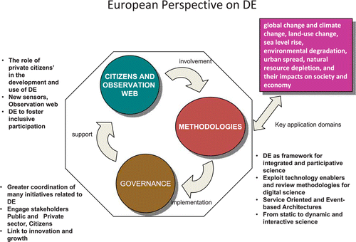
From a European perspective, this calls for a stronger integration of DE with INSPIRE, GMES and SEIS, the Shared Environmental Information System as well as GEOSS. Since each of these has different governance structures and drivers, the challenge is not trivial as documented by the GIGAS project.Footnote10 Moreover, there are multiple other initiatives taking place that need to be monitored and exploited, such as the development of Digital Cities,Footnote11 already in the framework of the ISDE, the establishment of the European Institute of Innovation & TechnologyFootnote12 in 2008, the Future and Emerging Technologies initiative and related proposalsFootnote13 and the numerous funding opportunities available under the Framework Research and Development programme of the EU. All of these initiatives will need to be targeted to address the innovation and sustainable growth challenges identified in the Europe 2020 Strategy and related initiatives on Innovation Union and Digital Agenda, which put high emphasis on ICT and research infrastructures, interoperability to foster innovation, and the ‘fifth freedom’ the free movement of researchers and innovative ideas. Embedding DE as a driver for science but also for innovation and growth will make it possible to flourish in Europe and contribute more strongly to the global objectives of the ISDE. summarises the three main topics identified from a European perspective.
Figure 1. Key topics on Digital Earth from a European perspective.
4. The way forward
During the workshop in Ispra in January, we identified some initial actions as the basis for discussion. They include
| 1. | To develop a more structured European research agenda and implementation mechanism, e.g. through the establishment of a European Digital Earth research Network (EDEN). This could:
| ||||||||||||||||||||||||||||||||||
| 2. | To establish a European Special Interest Group (SIG) and coordinate better the European effort and sustain organisational activities (see ). The SIG could:
| ||||||||||||||||||||||||||||||||||
Figure 2. European proposals.
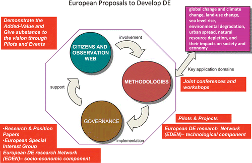
summarises the proposed activities in relation to the three main topics of the European perspective.
5. Conclusions
The paper has articulated some of the key areas of activity needed at the European level to promote the concept of Digital Earth and leverage the many opportunities that exist to make the concept a reality, addressing both scientific and social objectives. This European perspective has identified opportunities and synergies with the current policy priorities in Europe (Europe 2020, Innovation Union and Digital Agenda) and highlighted a number of priority actions to be taken in the coming months. At the same time, the perspective is offered to the international community, and the ISDE in particular, as a contribution to the collective reflection needed to arrive at a new and globally shared vision of DE.
We now need to operate on a dual track, at the European level to promote the concept of DE and raise awareness among the many actors able to support and influence its development. This shall focus on the three areas of (1) integrating scientific research into DE; (2) exploiting the Observation Web with human-centred sensing; and (3) governance, including the establishment of stronger linkages across the European landscape of funding streams and initiatives. At the international level, we will contribute to the development of this new vision of DE to be presented at the next International DE Conference in Perth, Australia, in August 2011. The global recognition of this new vision will then reinforce the European component and build a positive feedback loop for the further implementation of DE across the globe.
Notes on contributors
Alessandro Annoni is the Head of the Spatial Data Infrastructures Unit at the Joint Research Centre, European Commission. His main research interest is in innovative solutions for European policy making in relation to geo-information and the Environment.
Max Craglia is a Senior Scientist at the Joint Research Centre, European Commission. His main research interests are on geographic information policy and the assessment of socio-economic impacts of spatial data infrastructures.
Manfred Ehlers is Professor for GIS and Remote Sensing and Director, Institute for Geoinformatics and Remote Sensing (IGF) at the University of Osnabrueck, Germany. His main research interests are integration and fusion issues in GIS and remote sensing.
Yola Georgiadou is Professor of Geo-information and Governance, Faculty of Geo-information Science and Earth Observation (ITC), University Twente, The Netherlands. Her main research interest is the use of geo-information in public governance.
Andrea Giacomelli is coordinator of pibinko.org. His main research interests relate to GIS, organisational and social issues and projects to promote culture, environment, and free innovation.
Milan Konecny is Professor of Geography at Masaryk University, Brno, Czech Republic, and Vice-President of the International Society for Digital Earth. His main research interests are in GIS and cartography, and the development of Digital Earth.
Nicole Ostlaender works at the Joint Research Centre of the European Commission in Ispra, Italy. Her main research areas are Spatial Data Infrastructures, Volunteered Geographic Information, Workflow Modeling and Environmental Information Systems.
Gabor Remetey-Fülöpp is Secretary-General of the Hungarian Association for Geo-information (HUNAGI). His main research interest is networking aspects to access and use/reuse Geoinformation for socioeconomic benefits.
Professor David Rhind is Chairman of the UK government's Advisory Panel on Public Sector Information (including geospatial or geographic information). His main research interest is GI policy.
Paul Smits is a Senior Scientist at the Joint Research Centre, European Commission. His main research interests relate to geospatial data analysis, pattern recognition, data fusion, and interoperability.
Sven Schade is a post-doctoral researcher at the Spatial Data Infrastructures Unit of the European – Commission Joint Research Centre (JRC), Institute for Environment and Sustainability. His research focuses on future (Internet) technologies, especially in relation to Digital Earth, Observation Web and Linked Data.
Notes
1. An Official Web Site of the United States Government. Available from: http://www.data.gov/
2. The Federal Geographic Data Committee. Available from: http://www.fgdc.gov/
3. The Group on Earth Observation. Available from: http://earthobservations.org
4. INSPIRE. Available from: http://inspire.jrc.ec.europa.eu/
5. GMES. Available from: http://www.gmes.info/
6. The United Nations on Global Geographic Information Management http://unstats.un.org/unsd/geoinfo/meetings/10-11_may2010/
7. The Geographic Information Working Group https://sites.google.com/site/ungiwg11/
8. The Earth System Governance Project. http://www.earthsystemgovernance.org/
9. Internet Society. Available from: http://www.isoc.org/tools/blogs/scenarios/
10. GIGAS Project. Available from: http://www.thegigasforum.eu/project/project.html
11. Digital Cities. Available from: http://dcityresearch.net/
12. The European Institute of Innovation & Technology. Available from: http://eit.europa.eu/home.html
13. FuturICT. Available from: http://www.futurict.ethz.ch/FuturIcT
14. ESFRI. Available from: http://ec.europa.eu/research/infrastructures/index_en.cfm?pg=esfri
15. European Cooperation in Science and Technology (COST). Available from: http://www.cost.esf.org/
16. EIT ICT Labs. Available from: http://eit.europa.eu/kics1/eit-ict-labs.html
17. The Electronic Cultural Atlas initiative. Available from: www.ecai.org
Related Research Data
References
- Botts , M. 2008 . OGC sensor web enablement: overview and high level architecture . Lecture Notes in Computer Science , 4540 : 175 – 190 .
- Broering , A. , Foerster , T. , and Jirka , S. , 2010 . Interaction patterns for bridging the gap between sensor networks and the sensor web . In : Proceedings of 8th IEEE international conference on pervasive computing and communications: WoT 2010: first international workshop on the web of things , March 29–April 2 2010, Mannheim, Germany . Washington , D.C : IEEE Computes Society , 732 – 737 .
- Burgelman , J.C. , Osimo , D. , and Bogdanowicz , M. , 2010 . Science 2.0 (change will happen…) . First Monday , 15 (7). Available from: http://firstmonday.org/htbin/cgiwrap/bin/ojs/index.php/fm/article/view/2961/2573 [Accessed 13 January 2010] .
- Butler, D., 2006. 2020 computing: everything, everywhere. Nature, 440, 402–405 Available from: http://www.nature.com/nature/journal/v440/n7083/full/440402a.html [Accessed 3 February 2011].
- Craglia , M. , et al. ., 2008 . Next-generation digital earth: a position paper from the vespucci initiative for the advancement of geographic information science . International Journal of Spatial Data Infrastructures Research , 3 , 146 – 167 . Available from: http://ijsdir.jrc.ec.europa.eu/index.php/ijsdir/article/view/119/99 [Accessed 10 May 2011] .
- De Longueville , B. 2010 . Digital earth nervous system for crisis events: real-time sensor-web enablement of volunteered geographic information . International Journal of Digital Earth , 3 : 242 – 259 .
- European Commission , 2010a . Europe 2020: a strategy for smart, sustainable, and inclusive growth . COM(2010) 2020final. Available from: http://eur-lex.europa.eu/LexUriServ/LexUriServ.do?uri=COM:2010:2020:FIN:EN:PDF [Accessed 29 March 2011] .
- European Commission , 2010b . Europe 2020 flagship initiative innovation union . COM(2010) 546final. Available from: http://ec.europa.eu/research/innovation-union/pdf/innovation-union-communication_en.pdf#view=fit&pagemode=none [Accessed 29 March 2011] .
- European Commission , 2010c : A digital agenda for Europe . COM(2010) 245final/2. Available from: http://eur-lex.europa.eu/LexUriServ/LexUriServ.do?uri=COM:2010:0245:FIN:EN:PDF [Accessed 29 March 2011] .
- Fukui , H. , 2009 . Life on digital earth. Highlighting Japan [online]. Available from: http://www.gov-online.go.jp/pdf/hlj_ar/vol_0021e/24-25.pdf [Accessed 29 March 2011] .
- Goodchild , M.F. 2007 . Citizens as sensors: the world of volunteered geography . GeoJournal , 69 ( 4 ) : 211 – 221 .
- Gore , A. , 1998 . The Digital Earth: Understanding our planet in the 21st Century . Available from: http://portal.opengeospatial.org/files/?artifact_id=6210 [Accessed 10 May 2011] .
- Gore , A. 1999 . The Digital Earth: understanding our planet in the 21st century . Photogrammetric Engineering and Remote Sensing , 65 ( 5 ) : 528
- Guo , H.D. , Fan , X. and Wang , C. 2009 . A Digital Earth prototype system: DEPS/CAS . International Journal of Digital Earth , 2 ( 1 ) : 3 – 15 .
- International Council for Science (ICSU) , 2010 . Grand challenges in global sustainability research: a systems approach to research priorities for the decade . Available from: http://www.icsu-visioning.org/wp-content/uploads/GrandChallenges_Pre-publication.pdf [Accessed 29 March 2011] .
- International Symposium on Digital Earth (ISDE) , 1999 . Beijing declaration on digital earth [online]. Available from: http://www.geospatialworld.net/index.php?option=com_content&view=article&id=19976&Itemid=1036 [Accessed 29 March 2011] .
- Klopfer , M. and Simonis , I. 2009 . SANY – an open service architecture for sensor networks . SANY Consortium. ISBN 978-3-00-028571-4. Available from: http://sany-ip.eu/publications/3317 [Accessed 10 May 2011] .
- Pollit , C. and Hupe , P. , 2009 . Talking governance: the role of magic concepts . In : Paper presented at the EGPA Conference, 2–5 September, Saint Julian, Malta. Available from: http://www.egpa2009.com/documents/psg2/pollitt_hupe.pdf [Accessed 10 May 2011] .
- United States Group on Earth Observation , 2005 . About the US Group on Earth Observation (USGEO) [online]. Available from: http://usgeo.gov/index.php?option=com_content&view=category&layout=blog&id=34&Itemid=55 [Accessed 29 March 2011] .
- Woodgate , P. and Coppa , I. , 2008 . Virtual Australia – the next generation of research investments to help shape a nation . In : The International Archives of the Photogrammetry, Remote Sensing and Spatial Information Sciences. Vol. XXXVII. Part B2. Beijing 2008 . Enschede : International Society for Photogrammetry and Remote Sensing , 1085 – 1088 . Available from: http://www.isprs.org/proceedings/XXXVII/congress/2_pdf/12_SS-2/01.pdf [Accessed 29 March 2011] .