Abstract
Several innovative ‘participatory sensing’ initiatives are under way in East Africa. They can be seen as local manifestations of the global notion of Digital Earth. The initiatives aim to amplify the voice of ordinary citizens, improve citizens' capacity to directly influence public service delivery and hold local government accountable. The popularity of these innovations is, among other things, a local reaction to the partial failure of the millennium development goals (MDGs) to deliver accurate statistics on public services in Africa. Empowered citizens, with access to standard mobile phones, can ‘sense’ via text messages and report failures in the delivery of local government services. The public disclosure of these reports on the web and other mass media may pressure local authorities to take remedial action. In this paper, we outline the potential and research challenges of a ‘participatory sensing’ platform, which we call a ‘human sensor web.’ Digital Africa's first priority could be to harness continent-wide and national data as well as local information resources, collected by citizens, in order to monitor, measure and forecast MDGs.
1. Introduction
The notion of Digital Earth has not yet made inroads in Africa. Nevertheless, several innovative, indigenous African initiatives are under way in East Africa and elsewhere on the continent that resemble the global notion of a Digital Earth. These initiatives rely primarily upon mobile communication technology, short message service (SMS)-based services and innovative socio-technical information platforms that aim at ‘participatory sensing’ (Goldman et al. 2009) and the representation, often on Google Maps, of the needs of African citizens and grassroots organisations, especially regarding basic public services. The citizen acts as a human ‘sensor’ reporting failures of public services via her mobile phone, much like non-human sensors recording temperature, river flow, or the speed of vehicles. These initiatives have significant potential to help not only to monitor citizens' needs in a bottom-up manner but also to improve citizen-government relations in Africa, by making governments more accountable. Twaweza (www.twaweza.org), Ushahidi (www.ushahidi.com) and Daraja (www.daraja.org), are examples of ‘participatory sensing’ platforms, their names meaning ‘we can make it happen,’ ‘witness’ and ‘bridge,’ respectively, in Swahili.
The recent surge of these African innovations can be seen as a reaction to the partial failure of the millennium development goals (MDGs) to deliver accurate statistics on water, health and education services, among others. As the deadline for the MDGs approaches, the debate on how to shape a post-2015 MDG framework is picking up momentum. Most observers recognise the unprecedented political success of MDGs in mobilising support of politicians, civil society, industry and donors and building international consensus for human development and poverty reduction. The poor are counted, service levels are inventoried and data are aggregated to national levels and submitted to the United Nations (UN). But concerns about the data are increasing.
One concern is the lack of capacity in most countries to provide relevant, reliable and up-to-date national statistics (Saith Citation2006). A second concern is the lack of disaggregated monitoring below the national level. Vandemoortele (Citation2008, Citation2009), one of the chief architects of the MDGs, notes that disparities within the countries have grown to the point of slowing down national progress. Yet another concern is that some MDG indicators cannot be taken at face value, because they use both observation and over-optimistic assumptions in varying proportions. Vandemoortele (Citation2003) points out that statistics on water availability frequently overstate access to water in urban areas because they classify urban residents within 100 meters of a water point as adequately covered, assuming that the tap is working and the water is of good quality, which is often not true. Schools and hospitals are duly counted in the official statistics provided to the UN, but the assumption that schoolteachers and health workers are at work is frequently not true (Chaudury et al. 2006). As a UN Habitat in Nairobi, Kenya, puts it ‘current attempts to improve monitoring approaches have been hampered by the lack of reliable information at the local level, resulting in statistics which mask the true picture on the ground’ (UN Habitat 2010).
In this paper, we outline the potential and challenges of one such ‘participatory sensing’ platform, which we call a ‘human sensor web.’ We draw from our experience with the H2.O Monitoring Services to Inform and Empower program (2011) (www.h20initiative.org), launched in 2008 in East Africa by UN Habitat and Google.org. We conducted a pilot under this program and experimented with a rudimentary human sensor web in Zanzibar (http://geonetwork.itc.nl/zanzibar). The lessons we learned during the pilot and in subsequent focus group discussions with users and stakeholders form the backbone of the research we propose here to advance an African contribution to Digital Earth.
The rest of the paper is organised as follows. In Section 2, we summarise a decade of efforts to improve the capacity of government (statistics and national mapping) agencies in Africa to address aspirations framed in the United Nations Millennium Declaration (2000) (http://www.un.org/millennium/declaration/ares552e.pdf). We then highlight initiatives of ‘participatory sensing’ in East Africa. In Section 3, we summarise the challenges, based on our experiments with a human sensor web in Zanzibar and sketch out a research agenda. In Section 4, we outline the salient aspects of this research for Digital Africa. We conclude with recommendations for advancing a Digital Africa.
2. A Digital Africa?
2.1 A review of a decade from UNECA's point of view
Efforts to improve digital information sharing and coordination among statisticians, national mapping agencies and other producers of fundamental data via spatial data infrastructures in Africa go back to the first Committee on Development Information (CODI) Conference in 1999 (CODI-I Citation1999), organised by the United Nations Economic Commission for Africa (UNECA). Since then, UNECA and CODI (its subsidiary body), have played a critical role in helping build consensus around key African development challenges and in articulating common African perspectives and positions. The UNECA's power to convene senior policy-makers – through the annual Conference of Ministers of Finance, Planning and Economic Development – and other development stakeholders is pivotal in ensuring this role. The CODI Conference provides policy and technical guidance for the ‘harnessing information for development’ program. The program's objective is to assist African governments in discussing coordination issues related to the vast amount of geographic information needed to address the aspirations articulated by African and global initiatives, such as the United Nations Millennium Declaration.
Appeals for better coordination are made regularly at CODI conferences. For instance, CODI-III recognised that the ‘need to review [ … ] indicators in the light of the Millennium Development Goals and explicitly address Millennium Development Goals in the National Information and Communication Infrastructure (NICI) development process’ (CODI-III Citation2003, p. 18). At CODI-IV, the importance of spatial data to African initiatives was underlined: ‘statistical data, Geographic Information Systems (GIS) and ICTs [ … ] could be instrumental in assisting member States achieve the Millennium Development Goals (MDGs), address Poverty Reduction Strategies (PRS) and supporting the New Partnership for Africa's Development (NEPAD)’ (CODI-IV Citation2005, p. 2).
However, inter-agency coordination and digital data sharing is still fraught with problems, and arguably slower to implement in Africa than in more economically developed regions (Georgiadou and Homburg Citation2008, Homburg and Georgiadou Citation2009). The UNECAs most recent official report mentions the lack of policies, the reluctance of governments to implement policy guidelines and the lack of clarity on roles and responsibilities at national, provincial and local levels as the major impediments to inter-organisation coordination and sharing (United Nations Economic Commission for Africa 2009). Other challenges include the very limited funding allocated to development information, lack of facilities, obsolete equipment, the incompatibility of data formats amongst institutions and a majority of data-sets still in analogue form. Encouraging signs include a few countries with spatial data sharing coordinating bodies and working groups, new mapping initiatives, new mapping revision initiatives, an African metadata profile, and installed satellite positioning stations for the African reference frame (United Nations Economic Commission for Africa Citation2009).
In 2007, UNECA developed the MDG Mapper, a tool designed for visualising and analysing progress of Member States towards the MDGs, many of which are related to basic public services (CODI-V Citation2007). All data used in this application were procured from the official MDG Database maintained by the United Nations Statistics Division. Yet, concerns about the official MDG Database are increasing. Schools and hospitals are duly counted in the official statistics provided to the UN, but the assumption that schoolteachers and health workers are at work is frequently not true (Chaudury et al. Citation2006). National level statistics conceal the true picture on the ground (UN Habitat Citation2010).
2.2 Participatory sensing in Africa
The question arises as to whether and how ordinary citizens with standard mobile phones and no geo-ICT knowledge whatsoever can engage in participatory sensing of the quality of public services at the local level and then, if appropriate, demand improvements from government?
Public administration scholars distinguish three types of citizen-government relations: (1) citizen as a subject to state authority, (2) citizen as a client engaging in transactions with government, and (3) a citizen as a ‘citoyen’ participating in policy processes (e.g. van Duivenboden 2005). Information and Communication Technology (ICT) can potentially transform each of these citizen-government relations. For instance, location-based information and communication technology may provide the state with the ability to detect deviant behaviour of the ‘citizen as subject.’ It may enable government to cater to the needs of the ‘citizen as client.’ Finally, ICT can facilitate the involvement of the ‘citizen as citoyen’ in processes of decision and policy-making (van Ooijen 2008).
‘Citizens as voluntary sensors’ (Goodchild Citation2007) can contribute spatial data about their immediate and intimately familiar environment using Google Earth's Application Program Interface (API). However, citizens' submissions do not need to be limited to the geometric primitives of point, line or polygon (Georgiadou et al. Citation2011). Citizens can participate as active partners of government in the process of public policy-making or as ‘citoyens’ (van Duivenboden Citation2005, van Ooijen Citation2008). Citizens’ submissions and reports can be simple text messages sent from widely available mobile phones. With mobile phone coverage and ownership (International Telecommunications Union Citation2008) expanding rapidly in East Africa more and more initiatives are developed for ‘citoyens as sensors’ to make innovative use of mobile telephony and SMS-based services in East Africa: Kenya, Uganda and Tanzania. Numerous examples can be mentioned.
The Grameen Foundation (http://www.grameenfoundation.applab.org), famous for its micro-finance innovations, has been at the forefront of developing SMS applications in Uganda providing information to connected people on agriculture and health. In Kenya and Tanzania, various non-government organisations (NGOs) have taken up the development and implementation of mobile phone applications. Ushahidi developed a platform, currently used globally, to collect real-time information on disaster areas in particular (e.g. Chile and Haiti earthquake disaster response). But the platform is used in Kenya and Tanzania for other purposes as well. Most of the information acquisition there is geared towards governance and the provision of public services, such as safe drinking water and public health.
Twaweza uses mobile phone apps to monitor government performance (e.g. elections, performance of Members of Parliament) in Sub-Saharan Africa. One of its subsidiaries, Daraja.org developed its own water service monitoring system (MajiMatone) in three districts of Tanzania. By providing feedback to citizens through radio broadcasts and informing water authorities as well as local Members of Parliament with the same information, citizens are motivated to submit reports to the Daraja platform. Another prominent NGO, Kiwanja (http://www.kiwanja.net/), is responsible for several application developments including FrontlineSMS (http://www.frontlinesms.com/). The software allows citizens to set up their own SMS broadcasting station at very low cost and is already being used in 40 countries worldwide for all kinds of not-for-profit activities. Kiwanja also offers a repository of mobile phone applications in developing countries. Applications include ‘pill-check,’ where citizens can monitor and report the availability of essential drugs at clinics; ‘The Kenya Agricultural Commodity Exchange,’ informing farmers about the latest commodity prices; and SMS4life (http://www.rollbackmalaria.org/psm/smsWhatIsIt.html), which tracks the availability of malaria drugs.
2.3 Reflection
The novelty of these exciting developments is proportional to the difficulty of understanding and explaining their success or failure. To unravel the motivations, social characteristics and collective dynamics of ordinary citizens, texting location-based information and pressuring government to take action, we can only mobilise tentative hypotheses from other online collaborative domains (such as volunteered geographic information [VGI], Wikipedia, Free and Open Source Software movements), all of which involve more or less technologically savvy and expert individuals. Moreover, little is known about the behaviour of water and health officials towards information volunteered by ordinary citizens and their willingness or reluctance to grant legitimacy to citizen-generated data on their core business, provision of water and health services. Water and health officials are embroiled simultaneously in two different kinds of hierarchical accountability – to their political superiors in Tanzania and to international development banks (Rottenburg 2009), making a change towards accountability to citizens more elusive.
These challenges led us to experiment with a rudimentary human sensor web in Zanzibar, which we highlight in Section 3. The lessons we learned during the pilot (in the years 2009 and 2010) and subsequent focus group discussions with users and stakeholders in Arusha, Tanzania (in 2011) form the backbone of the research we further explain in Section 4 to advance an African contribution to Digital Earth.
3. Experiments and challenges for Digital Africa research
3.1 Experiments
In January 2008, UN Habitat and Google.org launched the H2.O Monitoring Services to Inform and Empower program (2011) (http://www.h20initiative.org/). Their aim was to develop a participatory and transparent manner of collecting citizen-level data on the quality of water services. Their ambition is to roll out the program in East Africa. In 2009 and 2010, we conducted a pilot under this program in Zanzibar. Our first aim was to experiment with a rudimentary ‘human sensor web’ – the ‘measurement’ or ‘sensing’ part of a novel, bottom-up social indicator system for water services. Our second aim was to identify further research for the roll out.
A rudimentary human sensor web (HSW; http://geonetwork.itc.nl/zanzibar) is an assembly of publicly available geographic web services, citizens with mobile phones (‘human sensors’) reporting and publicising water and health problems on the web, public water points and clinics, and stakeholders and users.
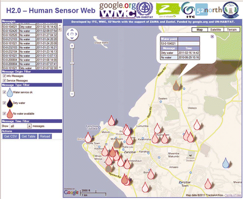
The concept is deceptively simple. For instance, citizens send SMS messages via standard mobile phones to report the lack or poor quality of water at a public water point: ‘no’ for no water and ‘dirty’ for dirty water (). These data are aggregated, anonymised and publicly disclosed in real time on the Internet, through Google Maps (). Those citizens, officials, NGOs or Members of Parliament who have Internet access can view this information. Officials can respond by, for example, alerting citizens that the problem has been solved or by diverting them to working water points nearby. The modularised architecture of the HSW can be extended to cover larger areas and populations and other public services including health and education services. The HSW can complement other mass broadcasting media in disclosing location-based failures in government services in a visual form that is easy to understand.
Figure 1. Example of a billboard design as put at 50 public water points in Zanzibar, urging people to report poor quality and/or lack of water via SMS to the water authorities.

Several scenarios for HSW use can be envisioned in Tanzania and the broader East African region. In the domain of public health, relevant applications include drugs and patient transport, medical staff performance, absentee doctors and nurses, availability of essential drugs stocks and medical equipment, gloves for nurses and sanitary pads for girls, outbreak of diseases, and emergency transport. In water provision, citizens' reporting may refer to water leakages, water prices by vendors, illegal water tapping, water quality and availability, among others. In the domain cutting across water and health, citizens' reporting can refer to waste water spills creating health hazards, water-borne diseases, shallow wells and latrines in proximity, and so on.
The study environment in Tanzania (including Zanzibar) is conducive to participatory sensing. As of September 2010, registered Tanzanian subscribers to mobile networks were 20,771,487, according to the Tanzania Communications Regulatory Authority. Internet cafes are widely diffused. Mobile services, offered by multiple providers, are increasing rapidly. Tanzania has about 24,182 Internet service hosts and about 1,000,000 Internet users. Tanzania is an example in democratic governance and peace consolidation in Africa. Human rights and the fundamental freedoms are practiced and guaranteed by the constitution. Democratic elections are held periodically. The latest elections were held in 2010. The ruling party now has about 80% of the seats in the Union Parliament and about 59% of the seats in the Zanzibar House of Representatives. The media are powerful and provide an overwhelming point of reference and vehicle for public debate, despite (or perhaps because of) the fact that the ruling party holds the majority of seats in parliament.
Figure 2. Example of real-time, public display of citizens' reports on Google maps.
3.2 Challenges
But significant research challenges have to be tackled first, as our fieldwork (September 2009 and 2010, in Zanzibar) and focus groups discussions (January 2011, in Arusha) with government authorities (water and health), NGOs, and traditional media (press, TV and radio) have shown.
The first challenge is ‘what kind of a hybrid of human and technological capabilities is a “human sensor”?’ A vignette from our fieldwork in Zanzibar illustrates how designers may inscribe human capabilities in software code. Citizens often send SMS stories about the lack of water, instead of texting the prescribed text (‘no’ or ‘dirty’). For example: ‘Greeting, how are you this holiday? In the area, Mwembe Shauri, there is no water since 7:00 in the morning; we do not know what the problem is. We request you to come and help us.’ Should the mobile phone be designed to prompt the citizen to enter the ‘right’ text (‘no’ or ‘dirty’) for the water situation? Might a ‘human sensor’ ask other ‘human sensors’ around the water point to type the ‘right’ text or should she alert the community leader (sheha) to act socially and organisationally? Should techniques already used by search engines be employed, where a user's often rambling query can elicit the often correct suggestion ‘Do you mean [this]?’ from the search engine?
The second challenge is related to citizens' reporting behaviour. Citizens will report problems with service delivery to independent parties, who they trust and who are closer to them than official authorities. Other media and community channels may be equally or more important for citizens than the HSW. Citizens will report if awareness is raised and if their expectations are met. Expectations can be ‘tolerable response time’ for feedback or results. People must clearly see a benefit – that their voice is heard and their grievance is taken to the Member of Parliament representing their district. They will report if educated on the importance of reporting problems with service delivery and if they feel free or at ease to report problems. This may be achieved through sensitisation and awareness creation from planning to implementation stages of a HSW implementation. Reporting mechanisms and feedback should be open to the public (e.g. web-based) without politicising issues. Involvement of different actors – NGOs, community based organisations (CBOs), local leaders, engineers, media – is crucial.
A third challenge is related to attitudes of public (water and health) service providers towards citizen reports. Water and health authorities do not have systematic mechanisms for tapping into client information. While health insurance is compulsory in Tanzania, citizens cannot take the availability of drugs and medical supplies in dispensaries for granted. Citizens’ reports are rarely collected and when collected not seriously considered. Government (water and health) agencies may use the HSW for two reasons: (1) to tap on citizens as informants (as ‘cheap labour’) to report on water and health issues in sparsely populated rural areas, and (2) as independent information to verify their own official information. Government agencies would not adopt the HSW to empower citizens, but only to do better and cheaper what they are already doing. Further, officials will only be willing to look at citizens' needs and grievances when these are splashed on the media (traditional and new) and become media events.
3.3 Research design
To address these challenges we designed a research agenda entitled ‘Sensors, Empowerment, and Accountability in Tanzania (SEMA).’ The acronym, SEMA, means ‘tell me’ in Swahili. At the heart of the research is the belief that the relationship between citizens and government can be improved if citizens can report (‘tell’) how they perceive the quality and availability of public services, via an innovative participatory sensing system, a ‘human sensor web.’ Reliable citizens' reports can help produce, together with government information, novel indicator systems to enhance the MDGs. The overall research question is ‘To what extent and how can citizens directly exact accountability from water and health service providers with the human sensor web (HSW)?’ The overall question can be broken down into four interrelated research directions/projects, shown in .
| 1. | Context modelling for HSW: Under which conditions can the context of a human sensor be used in a (web) software environment to enhance the understanding and reliability of human sensor information and how does context play a role in scalable human sensor networks? | ||||
| 2. | Citizens’ reporting behaviour: How will citizens behave in relation to HSW and become legitimate reporters of the quality of water and health services? | ||||
| 3. | Information and public accountability: Will water and health care officials/providers in Tanzania accept the HSW as part of their information and accountability structures? | ||||
| 4. | Reflexive management and scalability of HSW: How can the HSW be reflexively managed and scaled up in the broader East African region? | ||||
Figure 3. An integrated research approach regarding the feasibility and performance of a human sensor web.
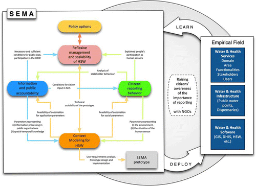
The second project provides a stakeholders’ list and parameters for each of them (from participant observation and focus groups) and social relations (family status, reliable contacts, phone use, socio-demographics). It provides an analysis of stakeholders behaviours (who trusts whom and why, perceptions of government agencies and possible consequences of actions; perceptions of own rights vs. interests; propensity to collective action).
The third project provides conditions for the acceptance by bureaucrats of citizen input in management information systems (MIS) and accountability and discretion practices. It also provides input on whether NGOs, as independent intermediaries, and media as creators of ‘political events,’ belong to these conditions.
The fourth project obtains reasons for participation of ‘human sensors’ and necessary and sufficient conditions for agency participation in HSW or other open source information systems. It addresses the issue of scalability of the software framework in terms of outreach, application domain and technology. For example, in the case of advanced technology, the smarter the phone, the more parameters can be logged (e.g. precise location and typing behaviour) and more sophisticated feedback can be provided to the ‘human sensor.’
4. Salient aspects of digital Africa research
In this section, we outline salient aspects of this research in terms of either the novelty of the subject matter itself or the specificity of the Tanzanian situation or of both.
4.1 Context modelling for HSW
It has been widely recognised for more than a decade that the notion of context is increasingly relevant for the interaction between human and computer, especially in the field of mobile computing (Schmidt et al. Citation1999) and pervasive computing (Bettini et al. Citation2010). Context has been defined by Dey (Citation2007) in a wider interpretation as ‘any information that can be used to characterise the situation of an entity. An entity is a person, place, or object that is considered relevant to the interaction between a user and an application.’ In this respect, context is modelled for the purpose of improving those applications, making them more meaningful. In mobile computing, we can distinguish between (1) applications that are serving a mobile user and (2) applications that are using inputs from mobile humans.
For the first type, telecommunication network providers are exploiting context-aware services to provide user-specific content to mobile phones, for instance based on mobile device specification and location by GPS or network cell (Johnson Citation2007). For the purpose of social networking, relevant content parameters are considered to be: outside light brightness, temperature, humidity, type of movement, in/outdoor location, and so on (Santos et al. Citation2010), some of which are not yet ubiquitous to mobile phone sensors.
The second type of applications is opening up complete new sources of information provided by ‘the crowd.’ Apart from the added value of the often local information, it also raises concerns about the credibility of this information and ways to assess this credibility (Flanagin and Metzger Citation2008). The notion of context has also been used as a means for better understanding websites and geo-information in particular (Handshuh et al. 2003, Keßler et al. Citation2009). Several initiatives are providing software frameworks for building context-aware systems (Dey Citation2000).
Building context-aware services implies machine understanding of context. This can be done by building trees of service types and user parameters for the purpose of service discovery (Doulkeridis et al. Citation2006). Other approaches are ontology-based (Behzadan et al. Citation2008, Soylu et al. Citation2009). The latter approaches allow for machine reasoning, resulting in the exchange of knowledge models across application domains. The application determines which kind of parameters need to be modelled. In line with other lists such as Schilit et al. (Citation1994) and Pascoe et al. (Citation2007), but more comprehensively, we distinguish between: device parameters (e.g. CPU; interface, such as keyboard and display; battery; etc.); characteristics of the human who is operating the device (skills, gender, social relations, etc.); device/user in situ parameters (location, direction, temperature, typing behaviour, etc.); and nearby entities such as humans, objects, events. Location and time are key parameters to which other context parameters can be attributed.
Methods of knowledge analysis with respect to location have been devised in different research fields such as geo-semantics engineering (Batcheller and Reitsma Citation2010) and spatial data mining (Mennis and Guo Citation2009). With respect to nearby entities, proximity is a network-based notion, which can be a relevant parameter with respect to location relationships and in the sense of social relationships and can be analysed by modelling these networks integrally (Preciado et al. Citation2011) thus also unveiling behavioural patterns (Eagle et al. Citation2009). In human observations, qualitative proximity expressions such as ‘near’ and ‘far’ have to be taken into account as well (Yao and Thill Citation2006).
During a period of collecting human sensor observations, the changing context over time can be analysed in a multi-parameter spatio-temporal setting. Dynamics of location changes can be considered a context parameter in itself, as human-computer interaction is influenced by it (Pascoe et al. Citation2000). For understanding the human sensor's spatio-temporal context, methods of geo-visual analytics (Thomas and Cook Citation2005, Andrienko et al. 2007) can facilitate the analysis of patterns, relationships and trends. More detailed questions include:
| 1. | How can context be defined and formally expressed? | ||||
| 2. | How can we reason with those expressions? | ||||
| 3. | How feasible is it to express particular parts of sensor context at a particular formalisation level? | ||||
| 4. | What is the minimum set of contextual parameters that should be taken into account at certain reliability levels? | ||||
| 5. | How can the relative location between multiple human sensors be exploited? | ||||
| 6. | How can information from nearby in situ sensors be used to determine context? | ||||
| 7. | How can context be portrayed at the human sensor side, at the operator side? | ||||
| 8. | How can we create and use persistent human sensor profiles? | ||||
| 9. | How can we utilise visual-analytics to detect patterns? | ||||
| 10. | How does context change with scale of the human sensor network (outreach, cross-domain, technical)? How can it be deployed under those different circumstances? | ||||
4.2 Citizens’ reporting behaviour
To understand citizens' reporting behaviour and its evolution over time the changing socio-technical reporting environments have to be taken into account. Two relevant changes are taking place simultaneously in East Africa. First, the transition to a market economy makes free public service only one of the possible ways for people to satisfy their needs. Second, citizens' uptake of mobile banking (M-Pesa) and of texting on the quality of water services (Daraja.org), on national elections and on humanitarian crises (Ushahidi.org), and human rights violations (FrontlineSMS) is surging in Eastern Africa. These changes can influence reporting behaviour and use of human sensor webs. Participatory sensing platforms are novel and have not yet been subjected to sustained scholarly scrutiny, making hypotheses hard to come by. However, citizens' capacity to act (or agency) and trust may be useful sensitising concepts.
Citizens’ capacity to act (or agency) depends on citizens' perception of their opportunities to voice grievances and the conditions (e.g. anonymity) under which they will take up technological capabilities to strengthen this capacity. Further useful notions are distributed agency (Rottenburg Citation2009), individual and collective agency (Surowiecki Citation2005) and anonymity (e.g. Lanier 2010). Distributed agency goes beyond the honesty of the individual reporting citizen, to examine how her agency is restricted by a translocal (family, gender, community, ethnic relations) agency that is situated somewhere up the chain. Collective agency needs to be balanced by individual agency or regulating mechanisms to counteract jittery behaviours of a crowd. Anonymity can evoke trolling behaviour if it is effortless, consequence-free and transient (drive-by anonymity, according to Lanier (Citation2010). Trolling and spamming is less likely, if the pseudonymous or anonymous personality of a reporting citizen requires work to create (e.g. SecondLife, eBay).
Trust is a vital determinant of the adoption and use of technology (Coleman et al. Citation2009). Trust may help explain how activity motivated by naked economic necessity is channelled along existing relations, in other words, how an open system like HSW bootstraps and scales (Hanseth and Aanestad Citation2003, Hanseth et al. Citation2006). Key theoretical notions here are categories of trust and their mutations over time. For M-PESA, a mobile banking application that achieved a remarkable local embeddedness in Kenyan society, trust was found to be a prerequisite for adoption, and a lubricant for its sustainability and growth (Morawczynski and Miscione Citation2010).
Understanding citizens' behaviour can draw from group-grid cultural theory to explain reporting behaviour of individuals and communities as an expression of shifting political cultures (Thompson Citation2008). An initial hypothesis is that the ‘low-grid’/‘high group’ (egalitarian) assumptions inscribed in HSW may collide with a ‘high-grid’/‘high group’ (hierarchical) local public administration context and/or may cohere with ‘low-grid’/‘low group’ (individualist) solutions of entrepreneurial water vendors, who turn the lack of public water into an opportunity to sell water. More detailed questions include:
| 1. | How do citizens relate basic needs and public services in the changing socio-technical environment? | ||||
| 2. | How do citizens perceive their capacity and opportunities to exact accountability? Under what conditions do citizens report? Do they organise as expected by HSW designers? | ||||
| 3. | How do local actors (community leaders, water vendors or private pharmacies, heads of family) interact with communities? | ||||
| 4. | What motivates citizens to report? Do they feel empowered? What feedback loops via web, radio, newspapers, SMS, face-to-face interactions can be supported? What rewarding system can be put in place? | ||||
4.3 Information and public accountability
In East Africa, donor-sponsored civil service and public sector reforms (Hirschmann Citation1999, Olowu Citation2003, Bana and McCourt Citation2006) make it likely that water and health providers/officials are simultaneously ruled by different and contradictory ‘imported’ and indigenous codes of behaviour, both in the management of information and in the organisation of accountability. To cope with this ambiguity and uncertainty, they have developed standard operating procedures and routines that reflect the cultural hybridity of information management and accountability structures and practices by local, national and foreign overseers. The question whether or not new HSW-generated or other open source information systems, driven by mobile phone and geo-information technologies, may be accommodated in the existing management information system (MIS) and accountability structures is a crucial part of the puzzle of co-construction (through constructive and interactive technology assessment) of HSW and other open source information systems by (potential) users and stakeholders and designers.
Constructive and interactive technology assessment broaden the design of new technology through feedback of (potential) users (Oudshoorn and Pinch Citation2005) and stakeholders and citizens into the actual construction of the technology. Technology assessment wants to address social, cultural and political issues around technology by influencing design practices.
The overarching theoretical approach to information and accountability issues raised by HSW-initiatives is group-grid cultural theory (Thompson et al. Citation1990, Hoppe Citation2007). Regarding MIS and information behaviour, we can rely on the seminal work by Thompson and Wildavsky (Citation1986) on cultural biases (and their hybrids) in information rejection in organisations; regarding differences between public management and control systems, Hood (Citation1998) offers valuable theory; and pertaining to issues of organisational accountability and individual discretionary space, we turn to Bovens (Citation1998).
The major hypothesis to be derived from cultural theory is that the more isolationist or hierarchical the organisation, the less they are inclined to allow citizen inputs through HSW or other open source information systems as part of organisational information and accountability practices. Alternatively, only individualist or egalitarian type organisations are likely to accommodate such information systems. More detailed questions include:
| 1. | How does the present information management system for water and health care providers/officials work? | ||||
| 2. | To what extent is this MIS based on informatisation technologies and e-governance standard operating procedures? | ||||
| 3. | To what extent does the MIS already contain routines of information sharing with citizens and information provision through citizens? | ||||
| 4. | Will water and health providers/officials be willing and able to accommodate HSW-generated information into their MIS and information behaviour routines? If not, why; if yes, why and under which conditions? | ||||
| 5. | Can and will HSW-generated information be somehow accommodated in organisational accountability routines and procedures (in politics, in the bureaucracy, in professional organisations to do with water and health care provision)? | ||||
| 6. | To what extent do organisational accountability systems leave room for individual discretion in organisations for water and health care provision? | ||||
4.4 Reflexive management and scalability of the HSW
The logic of management and scalability of the human sensor web follows its conceptualisation as an assembly of (1) open source geographic web services, (2) ‘human sensors’ reporting, (3) publicising, (4) water and health problems, (5) public water points and clinics, and (6) stakeholders and users.
Control of open source web services can be concentrated in the North or dispersed in the North and the South (Staring and Titlestad Citation2008). ‘Human sensors’ can be ordinary citizens, community activists, trained change agents, or professionals (water officials, nurses). The data captured by ‘human sensors’ can take multiple forms, from simple utterances to sophisticated reports. The audiences targeted by ‘human sensors’ can be multiple – specific individuals (water engineers, parliamentarians), organisations at different levels (district, regional, national) and international (UN, donors). The broadcasting media can be traditional (radio, local press, TV), the Internet (Google Maps) and combinations thereof. Problems can refer to other domains, beyond water and health, and affect other social actors. More detailed questions include:
| 1. | How to ensure that state-of-the-art open source geographic web services can be sustainably developed in the less economically developed South, instead of in expert nodes in the North? | ||||
| 2. | How to make the capture of idiosyncratic data more generic and how to address the diverse preferences for reports of multiple target audiences? | ||||
| 3. | How to allow various types of ‘human sensors’ to participate including professionals (water officials, nurses), activists and trained ‘change agents,’ in addition to ordinary citizens? | ||||
| 4. | How to distinguish users and stakeholders committed to the success of the HSW from those who have other options besides the technology at hand to solve their problem? | ||||
| 5. | How to characterise the water and health policy systems in Tanzania in terms of which political cultures participate and how they regulate interaction? | ||||
| 6. | How can an accountability structure to major stakeholders be created for HSW management? | ||||
Finally, innovative taxonomies of various HSW configurations and other global participatory sensing practices (Goldman et al. Citation2009) need to be developed in terms of (a) inclusiveness of diverse political cultures and (b) responsiveness – the deliberative styles they embody – for instance, using Ney's (Citation2006) pluralist democracy lens.
5. Conclusions
Africa's contribution to Digital Earth will be idiosyncratic, based on local innovations in participatory sensing, and responsive to local and global development agendas such as the United Nations Millennium Declaration. It will require sustained research involving technical and social scientists, from African and international academic institutions.
We distinguished four key dimensions for such research: (human) sensors, empowerment, accountability and scalability of participatory sensing platforms. The scientific aim is to assess the behaviour of human sensors and the reliability of their reports, the behavioural adaptability of bureaucrats in sharing policy-relevant information, as well as strategies for scalability and reflexive management of a human sensor web. The development aim is new knowledge on how human sensor webs and other participatory sensing platforms can empower citizens to improve public service delivery and to build up an interdisciplinary network of researchers and stakeholders in the monitoring of water and health services via human sensor webs.
Digital Africa's priority is to harness continent-wide and national data as well as local information resources collected by citizens in order to monitor, measure and forecast MDGs. A virtual Africa that allows ordinary citizens to text location-based failures in public services and make them publicly visible on the web can empower citizens, increase government accountability to citizens and support the aspirations of the United Nations Millennium Declaration.
Notes on contributors
Yola Georgiadou is Professor of Geo-information and Governance, Faculty of Geo-Information Science and Earth Observation (ITC), University Twente, The Netherlands. Her main research interest is the use of geo-information in public governance.
Benson Bana is Professor and Head of the Political Science and Public Administration Department, University Dar es Salaam, Tanzania. His main areas of research are administrative reform and delivery of public services.
Robert Becht is Assistant Professor, Faculty of Geo-information Science and Earth Observation (ITC), University Twente, The Netherlands. He was the co-leader of the HSW pilot in Zanzibar.
Robert Hoppe is Professor of Policy and Knowledge, Faculty of Management and Governance, University Twente, Enschede, The Netherlands. His main areas of research are policy change dynamics and innovation, especially the role of technology.
Justinian Ikingura is Professor and Dean of the School of Informatics and Communication Technologies, University Dar es Salaam, Tanzania. His main area of research is environmental transformation of mercury in tropical aquatic systems and implications on human health.
Menno-Jan Kraak is Professor of Space-Time Data Integration and Visualization, Faculty of Geo-information Science and Earth Observation (ITC), University Twente, The Netherlands. His main area of research is visualisation of the temporal component of spatial data.
Kate Lance is SERVIR Evaluation Lead, National Space Science and Technology Center, Huntsville, Alabama, USA and Ph.D. student at ITC, University Twente, The Netherlands.
Rob Lemmens is Assistant Professor, Faculty of Geo-information Science and Earth Observation (ITC), University Twente, The Netherlands. His main areas of research are geo-web technology, spatial data infrastructures and geo-semantic information modelling.
Juma Hemed Lungo is Lecturer in Computer Science, School of Informatics and Communication Technologies, University Dar es Salaam, Tanzania. His main area of research is the design and implementation of Free and Open Source Software (FOSS).
Michael McCall is Associate Professor, Faculty of Geo-information Science and Earth Observation (ITC), University Twente, The Netherlands. His main areas of research are participatory spatial planning and community-based natural resource management.
Gianluca Miscione is Assistant Professor, Faculty of Geo-information Science and Earth Observation (ITC), University Twente, The Netherlands. His main area of research is the use of geo-information in organisational processes.
Jeroen Verplanke is Lecturer/Researcher, Faculty of Geo-information Science and Earth Observation (ITC), University Twente, The Netherlands. He was the co-leader of the HSW pilot in Zanzibar.
Acknowledgements
We thank Dr Andreas Wytzisk of con terra GmbH (http://www.conterra.de/), Germany, for his substantial contributions to the design and implementation of the pilot human sensor web in Zanzibar.
Related Research Data
References
- Andrienko G. 2007 Geovisual analytics for spatial decision support: setting the research agenda International Journal of Geographical Information Science 21 8 839 857
- Bana , B. and McCourt , W. 2006 . Institutions and governance: public staff management in Tanzania . Public Administration and Development , 26 : 395 – 407 .
- Batcheller , J.K. and Reitsma , F. 2010 . Implementing feature level semantics for spatial data discovery: supporting the reuse of legacy data using open source components. Computers . Environment and Urban Systems , 34 ( 4 ) : 333 – 344 .
- Behzadan , A. 2008 . Ubiquitous location tracking for context-specific information delivery on construction sites . Automation in Construction , 17 ( 6 ) : 737 – 748 .
- Bettini , C. 2010 . A survey of context modelling and reasoning techniques . Pervasive and Mobile Computing , 6 ( 2 ) : 161 – 180 .
- Bovens , M.A.P. 1998 . The quest for responsibility. Accountability and citizenship in complex organisations , Cambridge : Cambridge University Press .
- Chaudury , N. 2006 . Missing in action: teacher and health worker absence in developing countries . Journal of Economic Perspectives , 20 : 91 – 116 .
- CODI-I , 1999 . Report of the first meeting of the Committee on Development Information (CODI I): harnessing information for development . Subcommittee on Geoinformation , 28 June–2 July 1999, Addis Abeba, Ethiopia: Economic Commission for Africa .
- CODI-III , 2003 . Report of the third meeting of the Committee on Development Information (CODI II): information and governance . Subcommittee on Geoinformation , 10–13 May 2003, Addis Abeba, Ethiopia: Economic Commission for Africa .
- CODI-IV , 2005 . Report of the fourth meeting of the Committee on Development Information (CODI IV): information as an economic resource . Subcommittee on Geoinformation , 23–28 April 2005, Addis Abeba, Ethiopia: Economic Commission for Africa .
- CODI-V , 2007 . Report of the fifth meeting of the Committee on Development Information (CODI V): employment and the knowledge economy . Subcommittee on Geoinformation , 29 April–4 May 2007, Addis Abeba, Ethiopia: Economic Commission for Africa .
- Coleman , D.J. , Georgiadou , Y. and Labonte , J. 2009 . Volunteered geographic information: the nature and motivation of producers . International Journal of Spatial Data Infrastructures Research (IJSDIR) , 4 : 332 – 358 .
- Dey , A. , 2000 . Providing architectural support for building context-aware applications . Thesis (PhD). College of Computing, Georgia Institute of Technology .
- Dey , A. 2007 . Understanding and using context . Personal and Ubiquitous Computing Journal , 5 ( 1 ) : 4 – 7 .
- Doulkeridis , C. , Loutas , N. and Vazirgiannis , M. 2006 . A system architecture for context-aware service discovery . Electronic Notes in Theoretical Computer Science , 146 ( 1 ) : 101 – 116 .
- Eagle , N. , Pentland , A. and Lazer , D. 2009 . Inferring social network structure using mobile phone data . Proceedings of the National Academy of Sciences (PNAS) , 106 ( 36 ) : 15274 – 15278 .
- Flanagin , A. and Metzger , M. 2008 . The credibility of volunteered geographic information . GeoJournal , 72 ( 3–4 ) : 137 – 148 .
- Georgiadou , Y. , Budhathoki , N.R. , and Nedovic-Budic , Z. , 2011 . An exploration of SDI and volunteered geographic information in Africa . In : Z. Nedovic-Budic , J. Crompvoets , and Y. Georgiadou Spatial data infrastructure in context: north and south . London : Taylor and Francis-CRC Press , 203–218.
- Georgiadou , Y. and Homburg , V. , 2008 . The argumentative structure of spatial data infrastructure initiatives in America and Africa . In : C. Avgerou , M.L. Smith , and P. van den Besselaar Social dimensions of information and communication technology policy: proceedings of the 8th International conference on human choice and computers , HCC8, IFIP TC 9, 25–26 September 2008, Pretoria, South Africa . Boston : IFIP International Federation for Information Processing , 282 , 31 – 44 .
- Goldman , J. , et al. , 2009 . Participatory sensing, a citizen-powered approach to illuminating the patterns that shape our world , White paper, Center for Embedded Networked Sensing (CENS), UCLA. Available from: http://wilsoncenter.org/topics/docs/participatory_sensing.pdf [Accessed 27 April 2011] .
- Goodchild , M.F. 2007 . Citizens as voluntary sensors: spatial data infrastructure in the world of web 2.0 . International Journal of Spatial Data Infrastructures Research (IJSDIR) , 2 : 24 – 32 .
- Handschuh S. Staab S. Volz R. On deep annotation Proceedings of the twelth international world wide web conference 2003 May Budapest, Hungary, 431–438. doi: 10.1145/775152.775214
- Hanseth , O. and Aanestad , M. 2003 . Design as bootstrapping – on the evolution of ICT networks in health care . Methods Informatics and Medicine , 42 : 385 – 391 .
- Hanseth , O. 2006 . Reflexive standardization. Side-effects and complexity in standard-making . MIS Quarterly , 30 ( Special issue ) : 563 – 581 .
- Hirschmann , D. 1999 . Development management versus Third World bureaucracies: a brief history of conflicting interests . Development and Change , 30 : 287 – 305 .
- Homburg , V. and Georgiadou , Y. 2009 . A tale of two trajectories: how spatial data infrastructures travel in time and space . The Information Society , 25 ( 5 ) : 303 – 314 .
- Hood , C. 1998 . The art of the state , Oxford : Clarendon Press .
- Hoppe , R. 2007 . “ Applied cultural theory as a tool in policy analysis ” . In Handbook of policy analysis , Edited by: Fischer , F. , Miller , G. and Sidney , M. 289 – 308 . Boca Raton , FL : CRC Press Frances Taylor Group .
- International Telecommunications Union (ITU) , 2008 . Africa has 300 million mobile phone subscribers, 13 June 2008. Available from: http://www.itu.int/ITU-D/ict/newslog/Africa+Has+300+Million+Mobile+Phone+Subscribers.aspx [Accessed 27 April 2011] .
- Johnson , S. 2007 . A framework for mobile context-aware applications . BT Technology Journal , 25 ( 2 ) : 106 – 111 .
- Keßler , C. , Janowicz , K. , and Bishr , M. , 2009 . An agenda for the next generation gazetteer: geographic information contribution and retrieval . In: 17th ACM SIGSPATIAL – International Conference on Advances in Geographic Information Systems (ACM SIGSPATIAL GIS 2009) , Seattle, Washington, 4–6 November 2009 . New York : ACM , 91 – 100 .
- Lanier , J. 2010 . You are not a gadget: a manifesto , London : Allen Lane, Penguin Books .
- Mennis , J. and Guo , D. 2009 . Spatial data mining and geographic knowledge discovery – an introduction . Computers, Environment and Urban Systems , 33 ( 6 ) : 403 – 408 .
- Morawczynski , O. and Miscione , G. , 2010 . Trustworthy mobile transactions: a longitudinal study on M-Pesa in Kenya . In : D. Latusek and A. Gerbasi Trust and technology in a ubiquitous modern environment: theoretical and methodological perspectives . Chapter 10, Hershey , PA : Information Science Reference, 160–173 .
- Ney , S. , 2006 . Messy issues, policy conflict and the differentiated polity: analysing contemporary policy responses to complex, uncertain and transversal policy problems . Thesis (PhD). University of Bergen, Norway. Available from: http://bora.uib.no/bitstream/1956/1512/1/Thesis-Ney.pdf [Accessed 27 April 2011] .
- Olowu , D. 2003 . Local institutional and political structures and processes: recent experience in Africa . Public Administration and Development , 23 ( 1 ) : 41 – 52 .
- Oudshoorn , N. and Pinch , T. 2005 . How users matter. The co-construction of users and technology , Cambridge , MA : MIT Press .
- Pascoe , J. , Ryan , N. and Morse , D.R. 2000 . Using while moving: HCI issues in fieldwork environments . ACM Transactions on Computer-Human Interaction , 7 ( 3 ) : 417 – 437 .
- Pascoe , J. , Thomson , K. , and Rodrigues , H. , 2007 . Context-awareness in the wild: an investigation into the existing uses of context in everyday life. Lecture notes in computer science, volume 4805, on the move to meaningful internet systems 2007 : OTM 2007 Workshops , 193 – 202 .
- Preciado , P. , et al. , 2011 . Does proximity matter? Distance dependence of adolescent friendships . Social Networks , DOI: 10.1016/j.socnet.2011.01.002 (in press) .
- Rottenburg , R. 2009 . Far-fetched facts, a parable of development aid , Cambridge , MA : MIT Press .
- Saith , A. 2006 . From universal values to millennium development goals: lost in translation . Development and Change , 37 : 1167 – 1199 .
- Santos , A.C. 2010 . Providing user context for mobile and social networking applications . Pervasive and Mobile Computing , 6 ( 3 ) : 324 – 341 .
- Schilit , B.N. , Adams , N.I. , and Want , R. , 1994 . Context-aware computing applications . In Proceedings of the workshop on mobile computing systems and applications , December 1994, Santa Cruz, CA . Washington , DC : IEEE Computer Society , 85 – 90 .
- Schmidt , A. , Beigl , M. and Gellersen , H-W. 1999 . There is more to context than location . Computers and Graphics , 23 ( 6 ) : 893 – 901 .
- Soylu , A. , Causmaecker , P.D. and Desmet , P. 2009 . Context and adaptivity in pervasive computing environments: links with software engineering and ontological engineering . Journal of Software , 4 ( 9 ) : 992 – 1013 .
- Staring , K. and Titlestad , O.H. 2008 . Development as free software: extending commons-based peer production to the South . In: Proceedings of the twenty ninth International Conference on Information Systems (ICIS 2008) , 22 April 2008, Paris. Atlanta, GA: Association for Information Systems. Available from: http://aisel.aisnet.org/icis2008/50 [Accessed 27 April 2011] .
- Surowiecki , J. 2005 . The wisdom of crowds: why the many are smarter than the few and how collective wisdom shapes business, economies, societies and nations , New York : Little, Brown .
- Thomas , J.J. and Cook , K.A. , 2005 . Illuminating the path. The research and development agenda for visual analytics . Los Alamitos , CA : IEEE Computer Society .
- Thompson , M. 2008 . Organising and disorganising: a dynamic and non-linear theory of institutional emergence and its implications , Axminster : Triarchy Press .
- Thompson , M. , Ellis , R. and Wildavsky , A. 1990 . Cultural theory , Boulder , CO : Westview Press .
- Thompson , M. and Wildavsky , A. 1986 . A cultural theory of information bias in organizations . Journal of Management Studies , 23 ( 3 ) : 273 – 286 .
- UN Habitat , 2010 . Google and UN-Habitat Partnership to improve data collection , 14 January 2010, Zanzibar. Available from: http://www.unhabitat.org/content.asp?cid=7751&catid=5&typeid=6&subMenuId=0 [Accessed 27 April 2011] .
- United Nations Economic Commission for Africa . 2009 . CODIST.1 – report on member states activities since CODI V . Geo-information Sub-committee, 28 April to 1 May 2009, Addis Abeba, Ethiopia.
- Vandemoortele , J. , 2003 . The MDGs and pro-poor policies: can external partners make a difference? Poverty Group, UN Development Program, December 2003, New York .
- Vandemoortele , J. 2008 . Making sense of the MDGs . Development , 51 ( 2 ) : 220 – 227 .
- Vandemoortele , J. , 2009 . Taking the MDGs beyond 2015: hasten slowly . Available from: http://www.eadi.org/fileadmin/MDG_2015_Publications/Vandemoortele_PAPER.pdf [Accessed 27 April 2011] .
- van Duivenboden , H. 2005 . “ Citizen participation in public administration: the impact of citizen-oriented public services on government and citizens ” . In Practicing e-Government: a global perspective , Edited by: Khosrow-Poor , M. 415 – 445 . Hershey , PA : Idea Group Publishing .
- van Ooijen , C.W. , 2008 . Territorialising eGovernment: institutional innovation through the use of location aware technologies . Public Administration European Group of Public Administration Conference , 3–6 September 2008, Rotterdam, The Netherlands. Available from: http://arno.uvt.nl/show.cgi?fid=95230 [Accessed 27 April 2011]
- Yao , X. and Thill , J-C. 2006 . Spatial queries with qualitative locations in spatial information systems . Computers, Environment and Urban Systems , 30 ( 4 ) : 485 – 502 .
- Zuckerman , E. , 2010 . Decentralizing the mobile phone: a second ICT4D revolution? Information Technologies and International Development . Vol. 6, Special Edition 2010 (Harvard Forum II Essays), 99–103. Available from: http://itidjournal.org/itid/article/view/631/271 [Accessed 27 April 2011] .