Abstract
On site observation is the most common way of monitoring cultural heritage sites and monuments in Cyprus. However, this procedure that includes data collection, periodical observations, and multivariate risk assessment analysis is difficult to accomplish with the traditional practices and methods since it is time consuming and expensive. Furthermore, many archaeological sites and monuments are located at inaccessible areas, far away from the main road network and urban areas. Satellite remote sensing and Geographical Information Systems (GIS) can successfully confront this problem by providing the scientists with integrated monitoring of the study areas and the unique advantage to store and manipulate a large amount of spatial and attribute data simultaneously. Actually the monitoring and identification of several natural and anthropogenic hazards in the vicinity of the cultural heritage sites in Cyprus, seems to be one of the main priorities of its governmental and municipal authorities. This study aims to integrate both satellite remote sensing techniques and GIS in a multidisciplinary approach, for monitoring anthropogenic and natural hazards with the use of archived and up-to-date multitemporal remotely sensed images in the study area, namely in areas nearby cultural heritage sites and monuments in Cyprus. In this study anthropogenic hazards include urbanisation and extended land use changes in the surroundings of archaeological sites and natural hazards concern seismicity and sea erosion.
1. Introduction
This paper aims to examine and evaluate the overall risk of cultural heritage (CH) sites in Cyprus due to anthropogenic and natural hazards. Cyprus is an island in the Eastern Mediterranean Sea that hosts numerous CH sites from the late antiquity until recent times. The risk evaluation will be performed using GIS and Remote Sensing techniques in order to highlight the benefit of such tools for monitoring CH sites and their surroundings in a systematic way. Because of the strong spatio-temporal component of natural hazards, maps can play a decisive role in communicating risk information (Dranch et al. 2010). The regional GIS-based modelling of environmental resources, and therefore ecosystems in general, requires setting up an extensive geo and model database (Bareth Citation2009). The conservation of cultural heritage is endangered by different environmental and human hazards such as air pollution agents, sea erosion and uncontrolled urban activities. The tools used for the management of the archaeological, environmental and spatial information should be able to transform different heterogeneous data to manageable form as well as to enhance the integration and assessment capabilities (Carlon et al. Citation2002). Indeed such tools can homogenous all such different hazards that includes among others earthquakes, tsunamis, landslide and mudslide, tornados, floods, coastal storms and erosions, droughts, wildfires, volcanic eruptions, urban fires, uncontrolled urban expansion and so on.
Both GIS and remote sensing have been applied to a wide range of different environmental projects (Rajitha et al. Citation2007, Vafeidis et al. Citation2007). Moreover, the ability of GIS to store, manipulate and combine multiple heterogeneous data sets classifies them as an invaluable tool for archaeological research and risk assessment analysis. Nowadays, archaeology has become an application field for satellite remote sensing and during the last decades archaeological sites are detected through the use of high resolution satellite images (Menze and Sherratt Citation2006). A number of different satellite sensors have been employed in different archaeological projects spanning from the identification of spectral signatures within archaeological sites to the management of archaeological sites and mapping of subsurface remains (Cooper et al. Citation1991, Sarris et al. Citation1996, Liu et al. Citation2003, Rowlands and Sarris Citation2007). On the other hand, very few studies are dealing with the application of a risk assessment model to archaeological monuments. Canuti et al. (Citation2000) addressed the issue of geomorphologic hazard with regard to erosion, landslide and flood processes for the historical sites in Italy while Indirli (Citation2009) highlights the use of the GIS database in order to record natural hazards and structural vulnerability for historical centres. Additionally, Carlon et al. (Citation2002) used both anthropogenic and natural factors to create a risk assessment model concerning archaeological monuments in Venice. This specific study aims to create a hierarchy of the risk areas for an optimum future planning and management of archaeological sites. Thus, GIS and satellite remote sensing will be used simultaneously in an integrated, innovative approach combining the huge analysing capabilities of GIS spatial tools with the broad spectral potential of remote sensing images.
2. Cultural heritage sites
In the south coast of Cyprus eight of the most important archaeological and CH sites of the island are located. Through a GPS survey of the research team all the sited were recorded in GIS environment (). These sites are (from west to east): New Paphos, Yeroskipou, Palaepaphos, Kourion, Medieval Castle of Limassol, Amathous, Kalavasos and Kition (). All of them are exposed to open air and therefore could potentially be seriously affected by any kind of anthropogenic and natural hazards. The selected sites have been established in different historical periods beginning from the Bronze Age up to the medieval times with well preserved and visible archaeological and architectural remains although the construction material of each site varies significantly. However, all these sites are situated along the coastline surrounded by almost the same physical environment. Their significant archaeological and historical value highlights the necessity of their protection from risky environmental and anthropogenic hazards.
Figure 1. Cultural heritage sites mentioned in the text.
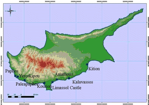
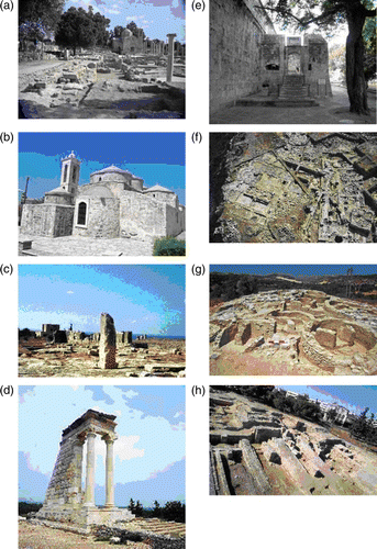
Figure 2. Photos of the CH sites. Data source: http://www.mcw.gov.cy
3. Methodology and data resources
3.1. Risk assessment
For risk assessment analysis, four main steps should be applied in order to evaluate the hazard and classify the monuments according to their vulnerability. These steps are:
3.1.1. Identification of the risk
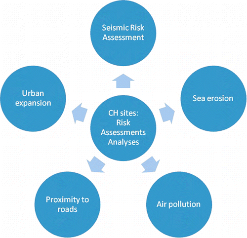
For the purpose of the study, both natural and anthropogenic hazards have been examined. Regarding natural hazards, seismicity, sea water erosion (distance from the sea) and erosion potential (geology and inclination) risk have been evaluated as the most common possible hazards with the highest availability of processing data. Concerning anthropogenic hazard four different factors such as air pollution, urban growth, vicinity to urban centres and proximity of roads to CH sites have been thoroughly analysed (). In addition some other hazards such as floods, fires and landslides are considered to be as occasional phenomena for Cyprus that threaten the under study archaeological sites but not with the frequency and the repeatability of other parameters. These hazards were selected among all the possible hazards since these were considered – for the first step – as the main hazards for CH sites in Cyprus. Secondary hazards will be evaluated and analysed in the future by the authors. Additionally, the specific study as a preliminary research for estimating risk of archaeological sites in a fast and flexible way does not take into account the possible vulnerability of the sites that could be inserted as parameter to the model by building up a detailed digital database concerning building structural and architectonic characteristics. The case study area was set at the south coastal plains of Cyprus where the main archaeological sites are located. Again more CH site will be plotted and examined in the near future by the authors in order to provide a useful tool and methodological framework to the local authorities.
Figure 3. Risk parameters analysed in this paper.
3.1.2. Profile hazards
After the study region has been selected and the potential hazards to be examined have been defined, the next step is the creation of a spatial ‘hazard’ database. Indeed the authors, by using auxiliary data provided from the Geological Department of Cyprus and the Department of Cadastral of Cyprus, created an integrated geo-database in GIS environment. The data were geo-referenced in a common geodetic system (WGS '84, 36N) using standard techniques (control points from digital maps). Moreover, concerning air pollution risk assessment and urban expansion, satellite imagery data were acquired. Specifically, satellite imagery of medium resolution from Landsat sensor was used. Regarding urban growth, Corine Land Cover dataset and GlobCover data were used.
3.1.3. Risk analysis
After the identification of the risks, all the necessary data were collected in order to be analysed with the use of spatial tools in GIS environment. Inventory data tables and maps were used. The data included topographic and geological maps, satellite images, digital elevation models and air pollution measurements.
Evaluation of the risk: the final step involved an overall in-depth evaluation of all the risks regarding the selected archaeological sites and monuments. The risk assessment outputs are in the form of tables and certain mitigation options are suggested by the authors.
4. Analysis
4.1. Seismic Risk of the CH Sites
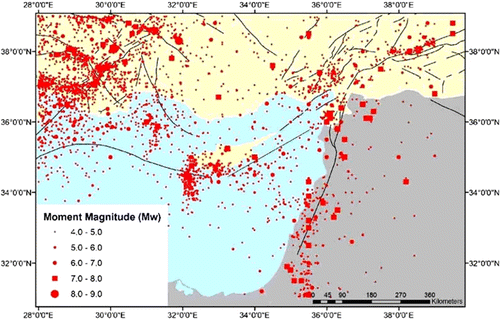
The complex tectonic regime of the eastern Mediterranean area is well recognised in numerous research papers. The Cyprean arc is considered to be the presently active plate boundary and accommodates the convergence between the African plate to the south and the Anatolian plate to the north (Papadimitriou and Karakostas Citation2006). The earthquake magnitudes can reach M = 7.0, according to historical data (). Moreover, it is well known that historical important sites of the island have been destroyed or severely damaged from earthquakes in the past (Galanopoulos and Delibasis Citation1965, Ambraseys and Adams Citation1993, Papazachos and Papaioannou Citation1999). Indeed several earthquakes led to the destruction of Salamis (east coast) at the beginning of the fourth century A.D. while Paphos (west coast) still suffers from earthquakes (Demosthenous et al. Citation1999).
Figure 4. Distribution of earthquakes in Cyprus from the antiquity (2150 B.C.) until 1995. Data Source: Geological Survey Department of Cyprus 1995.
Although seismic analysis has been widely applied in buildings (Chrysostomou et al. Citation2010) or even dams (Dai et al. Citation2005) all over the world, it is quite rare to find a seismic risk analysis for CH sites (e.g. Bani-Hani and Barakat Citation2006 for the historical site of Petra in Jordan, Hemeda and Pitilakis (Citation2010) for the Serapeum temple and the ancient annex daughter library in Alexandria, Egypt). This can be explained since CH sites are difficult to model and therefore difficult to examine in a seismic risk assessment. However, the study of possible causes of earthquake damage can assist the protection techniques from future earthquakes (Berilgen Citation2007).
Appropriate protection measurements from the local authorities can be carried out if the danger of an earthquake is considered to be substantial. Such measurements may include repairs or even strengthening of the historical monuments. Therefore, it is important that the required preservation, conservation and restoration actions of historical monuments are based on detailed studies of several different factors including seismic hazard (Bani-Hani and Barakat Citation2006).
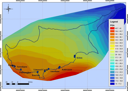
In order to evaluate the potential danger that the monuments are exposed to due to earthquakes, seismic hazard maps were used (data source: Cyprus Geological Survey). As it is shown in , the most prone area of Cyprus is the coastal zone that extends from Paphos to Limassol, Larnaca and Famagusta (west to east coastal areas of Cyprus). All the archaeological sites mentioned in the specific study are located in these seismogenic areas of the island. Starting from the available information on the Earth's structure, seismic sources, and the level of seismicity of the investigated area, it is possible to estimate peak ground acceleration (PGA) or any other parameter relevant to seismic engineering, which can be extracted from the computed theoretical signals. This procedure offers the alternative for a realistic estimation of the seismic hazard in those areas for which scarce (or no) historical or instrumental information is available and to perform the relevant parametric analyses (Panza et al. Citation2001). Concerning the concept of the return period this is of little value because all these archaeological sites should be handed down to next generations as intact as possible. The peak ground acceleration (PGA) values for Cyprus range from 0.16 g to 0.42 g (1 g = 9.81 m s−2 – average gravity of earth) (). Earthquake energy is dispersed in waves from the epicentre, causing ground movement horizontally (in two directions) and vertically. PGA records the acceleration (rate of change of speed) of these kinds of movements. The values of PGA vary depending on different factors such as the length of the relative fault, the magnitude of earthquake and the geology of the study area ().
Figure 5. Map showing the seismic hazard for Cyprus. PGA values for the island of Cyprus (percentage of average gravity of earth). Data source: Cyprus Geological Survey.
According to Kyriakides (Citation2007) PGA values have been recorded for the areas in the vicinity of the under study archaeological sites. Specifically, PGA values were estimated for a number of 15 major seismic events (magnitude > 4 Ms) in Cyprus during a time period of 100 years (1897–1997) with the contribution of a dense recording network ().
Table 1. List of 15 major seismic events in Cyprus.
The statistics revealed that in the broader area of Limassol (Limassol Castle, Kourion, Amathous) the mean value of PGA (as recorded from the stations of Limassol, Limassol Water Refinery and Yermasoyia Dam) was 0.25 g. Concerning Kition and Kalavasos archaeological sites (Kalavasos Station) the mean value was 0.21 g, for archaeological sites in the area of Paphos (Yeroskipou, Paphos) the mean value was 0.25 with a peak of 0.43 and for Palaepahos (Pissouri Station) the mean value was 0.19 g. For safety reasons against earthquakes, values of 0.2 g to 0.3 g (approximately) are taken into consideration for new building constructions in Cyprus.
4.2. Sea water erosion of the CH Sites
The CH sites located nearby the coastline may be threatened by shoreline erosion, sea wave storms, tsunamis, sea level rise and salt-decay (Alexakis and Sarris Citation2010, Robinson et al. Citation2010). For this purpose, buffer zones indicating the proximity of CH sites to the coastline were drawn in GIS environment (). The distance of CH sites from the coastline was categorised into five different classes: <500 m, 500–1000 m, 1000–2500 m, 2500–5000 m and >5000 m ().
Figure 6. Distance of Cultural Heritage Sites from the sea.
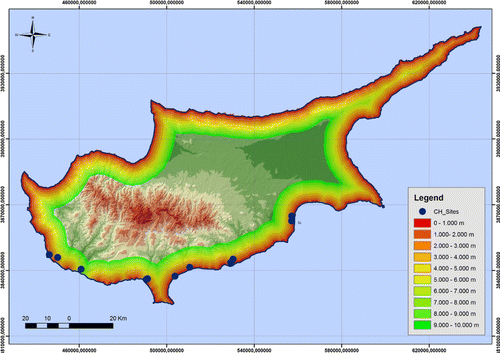
Table 2. Distance of CH sites from the coastline.
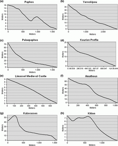
A thorough look at the exported results, led us to the conclusion that the majority of CH sites (four) are within a distance of less than 500 m from the coastline. Additionally, three CH sites (Kition, Palaepaphos and Kalavasos) are established in a zone of 1000–2500 m away from coastline and only Yeroskipou site is established in an area 2500 m away from the coastline. Regarding these data, preliminary draft researches from the Public Works Department of Cyprus highlighted the rate of sea erosion for every case study. Specifically, the erosion of coastline during the last decade was estimated as 1 m for Paphos (Paphos, Yeroskipou), 10 m for Kouklia (Palaepaphos), 1 m for Kourion (Kourion, Limassol Castle), 3 m for Kalavasos and 1 m for Kition. In addition the elevation profiles of all the archaeological sites from the coast denote that the rate of the present sea erosion does not threaten the archaeological heritage for the moment but they highlight its potential to the future ().
Figure 7. Elevation profiles of the archaeological sites from the nearest coastline.
Concerning tsunami mitigation, preparedness and early warning initiatives have begun at the global scale only after the tragic event of Sumatra in 2004 (Nurcan et al. Citation2011) and it is not in the goals of this paper. However the drawing of buffer zones from the coastline of the island is a measure of precaution against natural hazards such as tsunamis.
4.3. Erosion
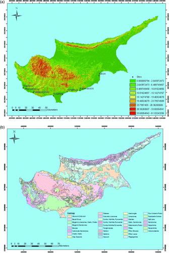
The phenomenon of erosion should never be ignored because of its importance in affecting landscape sustainability (Jiao et al. Citation2008, Wilson et al. Citation2008). Searching any possible erosion processes at the areas where the sites are established, two different factors were considered: the geological regime and the inclination of the relief. Using a 20 m pixel size Digital Elevation Model constructed in the GIS environment with the use of air photos stereo pairs (data provided from the Department of Land and Surveys, Cyprus), the slope map of the island of Cyprus was created in GIS environment (). All the sites are located at almost plain areas (lower than 5°) besides Kourion and Palaepaphos sites which are located on approximately 7° slope areas. Additionally, associating, in GIS environment, the inclinations with the geologic regime of the sites (mainly alluvium deposits and limestones) the possibility of erosion phenomena at the areas of CH sites was minimised. (A final geological map of Cyprus was created by using the digital map of Geological Survey Department of Cyprus and unifying the formations to a final number of 45 according to their petrologic characteristics – .) The majority of the sites are established at alluvium deposits (Medieval Castle, Kourion), carbonate sandstones (Kalavassos, Paphos, Yeroskipou, Kition) and biogenic limestones (Paleapahos, Amathus).
Figure 8. (a) Slope map of Cyprus. (b) Unified geological map of Cyprus.
4.4. Urban Expansion
Archaeological sites nearby the cities or villages are being threatened due to future urban expansion. Urban expansion (e.g. new roads, buildings) has become a daily phenomenon in some parts of the island. Local authorities, responsible for the protection of cultural heritage are commonly called to excavate and study archaeological remains brought to the surface from such kinds of activities. This phenomenon has generally negative economical impacts and leads to significant delays of the time schedule of many constructive projects.
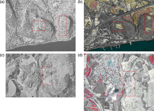
The rapid urban expansion all over the island has been indicated from Hadjimitsis et al. (Citation2005, Citation2009) and Agapiou et al. (Citation2010). Using archive satellite images (CORONA) and multispectral Landsat and QuickBird images the surrounding areas in numerous CH sites were found to have suffered remarkable land use change (). Moreover, by applying the change detection techniques in satellite remote sensing software ERDAS Imagine, it was proved that, in the surroundings of the archaeological site of Paphos, a 20% differentiation in the land use has occurred.
Figure 9. (a) Amathous archaeological site in 1963 CORONA image and 2010 Google Earth. (b) Amathous archaeological site in 2010 Google Earth image. (c) Palaepaphos archaeological site in 1963 CORONA image. (d) Palaepaphos archaeological site in 2004 QuickBird image. (Image © Digital Globe, © 2011 Europa Technologies, © 2011 Google Earth).
In order to model the future urban expansion, the CORINE Land Cover (CLC) database was used to map different human activity areas. The CLC data set provides a high-resolution description of land use patterns, making use of 44 different land cover classes (Janssen et al. Citation2008). All the villages and cities were mapped in GIS environment and a buffer zone of 1500 m was created around the towns. Additionally, a buffer zone of 500 m was created around the villages so as to proceed to a final extensive urban expansion analysis ( and ).
Figure 10. (a) Towns and villages of Cyprus. (b) Proximity of CH sites to urban centres. (c) Comparisons of urban areas for 2000 and 2009. (d) Spatial expansion of urban areas during the last decade.
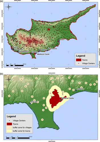
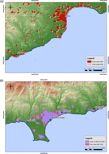
Table 3. Distance of CH sites from urban areas.
The results indicated that 50% of the selected archaeological sites are established within urban areas and the rest are in close vicinity with them. In order to be compared, urban changes over the last decade were recorded using the CLC and the GlobCover data of 2009 (c, d). As it was extracted from the direct comparison of these two datasets, a medium increase of urban area cover has been recorded during the last decade as it is indicated in . Specifically, the urban sprawl of Limassol, Larnaka and Paphos for the period of 2002–2009 rises to medium expansion rate between 2–6 km2. This fact is excused due to the vast urban construction projects that took place all over the island during the period of the late 1980s and 1990s.
Table 4. Urban expansion of Cyprus urban areas during the period of 2002–2009.
4.5. Proximity of CH sites to the roads
Proximity of CH sites to the local road network was another anthropogenic hazard taken into account in this paper. Air pollution nearby highways or town centres very often exceeds the regular limits and therefore can slowly deteriorate the building elements of the monuments. Moreover, accessibility of an archaeological area by the existing road network can promote future urban expansion with negative consequences to the preservation of CH sites. The major road network of Cyprus was created in digital format in GIS environment through the extensive digitisation of topographic maps (a). At a next step, buffer zones of 500 m and 1000 m were created around the road network, in order to examine the proximity of CH sites to the network (b, c). Moreover, the road network was classified into four categories according to its traffic vibration as follows: highway network, main road network, secondary road network and rural road network (d). Class 1 corresponds to the highway network of the island where the high capacity of vehicle is observed. Similarly class 2 is for main road network, class 3 for secondary road network and class 4 for rural road network. A value of one was assigned to the areas (zones) of more than 500 m away from the road network and a value of zero was assigned to the areas (zones) within a distance of 500 m from the road network ().
Figure 11. (a) Major road network of Cyprus. (b, c) Proximity of CH sites to road network. (d) Classification of road network.
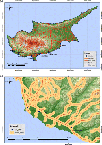
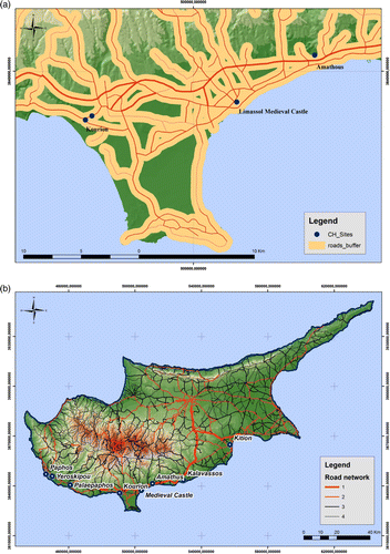
Table 5. Distance of CH sites from the major road network. In brackets the class of the road network is indicated.
The final results proved that all the CH sites are within a distance of 500 m from the main road network revealing that the sites are exposed to danger. Regarding the classification of the road network, the vast majority of the sites is in the vicinity of main road network and only Amathous and Kalavassos sites are located nearby to the highway road network of the island.
4.6. Air pollution and CH sites
Cultural heritage sites are under constant threat from air pollution (Brimblecomble Citation1991, Kucera and Fitz Citation1995, Metallo et al. Citation1995). Air quality monitoring stations have been established in different areas and provide means for alert. The measuring stations are scarcely distributed and they do not provide sufficient tools for mapping air pollution since air quality is highly variable. However, earth observations made by satellite sensors are certainly a valuable tool for assessing and mapping atmospheric pollution due to their major benefit of providing complete and synoptic views of large areas in one snap-shot. The use of earth observation to assess and map the air pollution in different geographical areas and especially in cities, has received considerable attention from researchers who developed a variety of techniques (for example, Kaufman et al. Citation1990, Wald et al. Citation1999, Hadjimitsis et al. Citation2002). The key parameter for assessing atmospheric pollution in photochemical air pollution studies is the aerosol optical thickness (Kaufman et al. Citation1990) that is retrieved through the atmospheric path radiance component, which is also the most important unknown parameter of every atmospheric correction algorithm for solving the radiative transfer (RT) equation and removing atmospheric effects from satellite remotely sensed images. Recently, Themistocleous et al. (Citation2010) used the revised darkest pixel method for assessing the air pollution in the areas located in the vicinity of cultural heritage sites in Cyprus. The determination of the aerosol optical thickness is found from the atmospheric path radiance component using standard calibration targets defined on the image, preferably dark targets. Based on previous studies on relating atmospheric path radiance and the aerosol optical thickness (Hadjimitsis and Clayton Citation2004, Hadjimitsis Citation2008, Citation2009), the authors use the atmospheric path radiance component as a tool for assessing the atmospheric conditions.
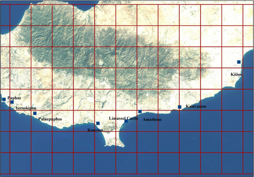
In order to analyse air pollution impact to the archaeological sites of Cyprus, atmospheric path radiance (Lp) and aerosol optical thickness (AOT) was determined for the cloud-free Landsat image () acquired on 23 August 2009 (). Path radiance is an indicator of air pollution in the area. The determination of atmospheric path radiance (and AOT) was carried out using the darkest pixel atmospheric correction method that has been found to be an effective method for the visible bands as shown by Hadjimitsis and Clayton (Citation2009). Using the method described by Hadjimitsis (Citation2009) the image was divided in grid cells as it is indicated in (10×10 Km) and the Lp for each grid was calculated.
Figure 12. Division of Landsat TM in grid cells.
Concerning Lp, values of Lp < 47 correspond to AOT = 0.13 for not very hazy atmospheres, values of Lp = 47–60 correspond to moderate AOT = 0.3–0.5, while values of Lp > 60–75 correspond to AOT > 0.5 that is considered as the starting point of air pollution events. These values are considered to be empirical derived from previous studies where they have already been applied (Hadjimitsis and Clayton Citation2004).
For retrieving the aerosol optical thickness from the darkest pixel approach, the authors used the algorithm suggested by Hadjimitsis and Clayton (Citation2009) and the final results related with the Lp are presented in .
Table 6. AOT measurements from satellite image (Landsat TM, 23 August 2009) for CH sites.
5. Overall risk assessment
In order to proceed to overall risk and vulnerability assessment of the archaeological sites in Cyprus due to anthropogenic and natural impact, a risk index was attributed to each different factor (urban activity, minimum distance of urban activity in the vicinity of an archaeological site, seismic PGA and air pollution impact). Although only seismic PGA can have an instant impact on the archaeological sites, however, the impacts of urban activity, urban vicinity and air pollution can be far less severe but yet equally serious. Specifically, concerning urban development, it is now controlled in Cyprus through local plans and area schemes published under the provisions of the planning legislation. However, planning in areas of the island that are not covered by local plans is exercised through the Policy Statement for the Countryside, which is accompanied by detailed designated land use and building density zones. Both of these plans should have the ability to monitor and immediately address spatial development issues.
The risk index was specified by the authors according to certain methodology: For each participating parameter, a value of zero was assigned in GIS environment to areas of low risk zones, a value of one was assigned to areas of moderate risk zones and finally a value of two was assigned to high risk areas. Regarding the five different factors:
5.1. Seismic PGA
According to historical data source (Cyprus Geological Survey) the peak ground acceleration (PGA) values for Cyprus range generally from 0.16 g to 0.42 g (1 g = 9.81 m s–2) and values between 0.2 g and 0.3 g are attributed for safety reasons against earthquakes to any new infrastructures in Cyprus. For the aims of this study the three following categories were determined:
| • | Low risk (factor = 0) for PGA values less than 0.2 g | ||||
| • | Moderate risk (factor = 1) for PGA values from 0.2 g to 0.3 g | ||||
| • | High risk (factor = 2) for PGA values over than 0.3 g | ||||
5.2. Sea erosion
CH sites nearby coastline are exposed daily to many threats including sea salt erosion. Salt is considered as a principal agent of decay in porous building and decorative materials. Indeed salt-decay can be identified either as efflorescence (salt growth on the surface of materials) or cryptoflorescence. The distance from the coastline is a key parameter for this threat. For this purpose the following distances were defined according to the risk of the CH sites:
| • | Low risk (factor = 0) for distance from the sea more than 2500 m | ||||
| • | Moderate risk (factor = 1) for distance from the sea from 500 to 2500 m | ||||
| • | High risk (factor = 2) for distance from the sea less than 500 m | ||||
5.3. Urban expansion
The cover area expansion of major urban centres of the island and how this socio-economic phenomenon affects the preservation of CH sites was recorded and classified as follows:
| • | Low risk (factor = 0) urban expansion between 0 and 2 km2 | ||||
| • | Moderate risk (factor = 1) urban expansion between 3 and 10 km2 | ||||
| • | High risk (factor = 2) urban expansion of more than 10 km2 | ||||
5.4. Distance from urban centres
The policy of Department of Antiquities and Department of Town Planning and Housing of Cyprus is authorised to protect by law the construction of parcels around the archaeological sites. This fact has inevitably caused serious problems to a holistic approach regarding urban activity near archaeological sites. For the aims of the study, the following categories were determined:
| • | Low risk (factor = 0) for distance from urban areas more than 1500 m | ||||
| • | Moderate risk (factor = 1) for distance from urban areas more than 500 and less than 1500 m | ||||
| • | High risk (factor = 2) for distance from urban areas less than 500 m | ||||
5.5. Proximity to road network
Distance of the CH sites from the current road network of the island was examined in this study. At the same time the road network was classified according to its traffic vibration. The final results were classified to the following classes:
| • | Low risk (factor = 0) for a distance of more than 1000 m from the road network | ||||
| • | Moderate risk (factor = 1) for a distance of less than 500 m from the road network and vicinity to major road network | ||||
| • | High risk (factor = 2) for a distance of less than 500 m from the road network and vicinity to highway road network | ||||
5.6. Air pollution (Lp values) impact
According to the relevant literature (Hadjimitsis and Clayton, Citation2009) values of Lp < 47 correspond to AOT = 0.13 for not extremely hazy atmospheres, values of Lp = 47–60 correspond to moderate values of AOT ranging from 0.3 to 0.5, while values of Lp > 60–75 correspond to AOT values greater than 0.5. Therefore, the impact of air pollution was categorised as follows:
| • | Low risk (factor = 0) for Lp values of less than 47 | ||||
| • | Moderate risk (factor = 1) for Lp values from 47 to 60 | ||||
| • | High risk (factor = 2) for Lp values over than 60 | ||||
5.7. Erosion
Although the geological formations where the sites are established are considered to be vulnerable to erosion phenomena, the low inclination (except Kourion and Palaepaphos) values minimise this possibility. Therefore the impact of erosion will be categorised as follows:
| • | Low risk (factor = 0) for slope values of less than 5° | ||||
| • | Moderate risk (factor = 1) for slope values from 5 to 10° | ||||
| • | High risk (factor = 2) for slope values over than 10° | ||||
The researchers used the AHP (analytic hierarchy process) in order to compare the different factors and their relative importance. The AHP is a flexible way of analysing complicated problems. It is a multicriteria objective decision-making approach that initiates the user to arrive at a scale of preferences drawn from a set of alternatives (Yalcin et al. Citation2011). According to the specific methodology, the final weight of significance for each factor can be defined using the eigen-vectors of a square reciprocal matrix of pairwise comparisons between the different factors. Moreover a certain grade is assigned to all the different pairs from 1 to 9 when the factor is ‘not important at all’ to 9 where the factor is ‘extremely important.’ Finally a total value of the sum weights of all rows is estimated and the final division of this value with the sums of each factor provides the final normalised weight of each individual factor ().
Table 7. Application of AHP methodology.
Finally, according to the above categories, the statistical results of the risk assessment analysis () were calculated. Examining the final results, Kourion, Limassol Medieval Castle and Amathous archaeological sites appear to have the most hazard potential taking into account both anthropogenic and natural factors. Considering the factors separately (anthropogenic and natural) once again the same sites seem to be the most prone to all encountered kinds of risk.
Table 8. Final statistic results of the risk assessment analysis.
6. Conclusions
The beneficial integrated use of satellite remote sensing with GIS has been demonstrated in this study for exploring the natural and anthropogenic hazard risk of the most significant cultural heritage sites in Cyprus.
Concerning the seismic risk assessment, the peak ground acceleration values indicated that all the monuments are located within the spatial limits of the most seismic prone areas in Cyprus. Additionally, regarding sea erosion, the study proved that 50% of the sites are within a distance of only 500 m away from the coastline making them vulnerable to related coastal hazards such as sea water erosion. The creation of buffer zones in GIS environment around CH sites explored the significant problem of extensive urbanisation in the vicinity of cultural heritage sites. Almost 50% of the CH sites are under severe urban pressure and 37.5% of the sites are within a radius of 500 m from the urban centres. Unfortunately, all the sites are in a distance of less than 500 m away from primary national road network, which does not protect them from irretrievable deterioration of their construction materials due to air pollution. The synoptic coverage of all the CH sites using a Landsat TM image permitted the retrieval of aerosol optical thickness in the broader area of all the archaeological sites and can assist the local authorities to the systematic monitoring of air pollution. Finally, the overall examination of the results proved that four of the most invaluable archaeological monuments in Cyprus are under substantial natural and anthropogenic pressure.
Contemporary technological means such as GIS and satellite remote sensing proved to be really efficient to the detailed mapping of the regime of CH sites in the island of Cyprus. This specific study revealed the different kind of natural and anthropogenic hazards that threaten the preservation of valuable CH sites. In addition it highlighted the urgent need for the construction of new local plans and an update of planning legislation in order to achieve the future goal of sustainable management of cultural heritage monuments. This task will include the control of urban expansion in the vicinity of the archaeological sites (including the control of air pollution and road network) and, of course, the designation of sophisticated plans for protecting the sites from any possible erosion and seismic events. Concerning estimation of losses from a possible destruction of standing architecture these are mainly dependent from the cover area of the site and mainly from its cultural asset either for the whole humanity or for the local society. Moreover, this study provides the authorities with the basic knowledge that can help them to specify the actions they need to take for the protection of national heritage from natural phenomena and anthropogenic impacts. The article should underline that this is a preliminary analysis, in order to identify the most prone sites. A deeper analysis should be done for each site in the future.
Notes on contributors
Diofantos G. Hadjimitsis is an Associate Professor at the Department of Civil Engineering & Geomatics at the Cyprus University of Technology (CUT). He is the Head of the Remote Sensing Lab at CUT. He has more than 200 publications in the field of remote sensing and geoinformatics. He holds a PhD and MPhil in Remote Sensing from Surrey University (UK), MSc in Real Estate and Property Management from Salford University (distinction) (UK), BEng in Civil Engineering (first class) from Surrey University (UK), and a Diploma in Civil Engineering from HTI in Cyprus. He is a reviewer of several international journals in the fields of remote sensing and geoinformatics intended for environmental surveillance.
Athos Agapiou MSc is a PhD Candidate in Remote Sensing Archaeology at the Department of Civil Engineering & Geomatics at the Cyprus University of Technology (CUT). He obtained his diploma degree from the School of Rural and Surveying Engineering at the National Technical University of Athens. He also holds a MSc in the field of Geoinformatics from the same University and an MA in Mediterranean Archaeology from the Department of History and Archaeology at Cyprus University. His research interests are in the field of Remote Sensing Archaeology, Geographic Information Systems (GIS), and Documentation Techniques for Cultural Heritage.
Dimitrios Alexakis is currently a Post-Doc scientific researcher at the Laboratory of Remote Sensing at the Department of Civil Engineering & Geomatics. He got his BSc degree from the School of Geology at the Aristotle University of Thessaloniki – Greece. He continued his MSc studies at the same department in the field of GIS and Satellite Remote sensing and he accomplished his PhD in the field of the Applications of Geomorphology, Satellite Remote Sensing and GIS to Archaeology. His scientific interests are focused on Satellite Remote Sensing, Geographical Information Systems, Hydraulics, Hydrology, Geomorphology and applications of contemporary means of technology to Archaeology.
Apostolos Sarris received his BA and MA from the Physics & Astronomy Department of Boston University and his MSc and PhD from the University of Nebraska at Lincoln, both in the United States. He is Director of Research at the Institute for Mediterranean Studies of the Foundation for Research & Technology (FORTH), and vice-chair of the International Society for Archaeological Prospection (ISAP). His research interests span from Geophysical Prospection of Archaeological Sites to Site Assessment and Modelling through GIS techniques, Satellite Remote Sensing and Image Processing. He has organised, planned and participated in more than 115 geophysical/satellite remote sensing/GIS/GPS projects in Greece, the United States, Cyprus, Hungary, Albania, and Egypt and participated in more than 50 Greek and international projects (European Community, NATO, USA-National Science Foundation, Wenner-Gren, Institute for Aegean Prehistory, General Secretary for Research and Technology Greece).
Acknowledgements
The authors acknowledge the Cyprus University of Technology/Department of Civil Engineering and Geomatics (Remote Sensing Laboratory) for supporting this study. They would also like to acknowledge the Geological Survey Department of Cyprus, the Department of Land and Surveys of Cyprus, the Public Works Department of Cyprus, Mr. Christos Efstathiades and Dr. Nicholas Kyriakides for their valuable contribution to specific topics of the paper.
References
- Agapiou , A. , Hadjimitsis , D. , and Sarris , A. , 2010 . Space technologies and geographic information systems used for monitoring natural and anthropogenic hazards: case studies at cultural heritage sites and monuments in Cyprus . In: 8th international symposium on the conservation of monuments in the Mediterranean basin, 31 May–2 June 2010, National Technical University of Athens, University of Patras, Technical Chamber of Western Greece, Patra, Greece .
- Alexakis , D. and Sarris , A. 2010 . Environmental and human risk assessment of the prehistoric and historic archaeological sites of Western Crete (Greece) with the use of GIS, remote sensing, fuzzy logic and neural networks . In: Lecture notes in computer science , Springer, Volume 6436 : 332 – 342 .
- Ambraseys , N.N. and Adams , R.D. 1993 . Seismicity of the Cyprus region . Terra Nova , 5 : 85 – 94 . doi: 10.1111/j.1365-3121.1993.tb00229.x
- Bani-Hani , K. and Barakat , S. 2006 . Analytical evaluation of repair and strengthening measures of Qasr al-Bint historical monument – Petra, Jordan . Engineering Structures , 28 ( 10 ) : 1355 – 1366 . doi: 10.1016/j.engstruct.2005.10.015
- Bareth , G. 2009 . GIS- and RS-based spatial decision support: structure of a spatial environmental information system (SEIS) . International Journal of Digital Earth , 2 ( 2 ) : 134 – 154 . doi: 10.1080/17538940902736315
- Berilgen , M.M. 2007 . Evaluation of local site effects on earthquake damages of Fatih Mosque . Engineering Geology , 91 ( 2–4 ) : 240 – 253 . doi: 10.1016/j.enggeo.2007.02.001
- Brimblecomble , P. 1991 . “ History of air pollution and damage to the cultural heritage of European cities, science technology and European cultural heritage ” . In European symposium , 51 – 66 . Italy : Bolognia .
- Canuti , P. 2000 . Hydrogeological hazard and risk in archaeological sites: some case studies in Italy . Journal of Cultural Heritage , 1 : 117 – 125 . doi: 10.1016/S1296-2074(00)00158-8
- Carlon , C. June 2002 2002 . “ ArcheoRisk: a decision support system on the environmental risk for archeological sites in the Venice lagoon ” . In Proceedings of the 1st biennial meeting of the iEMSs June 2002 , 24 – 27 . Switzerland , Lugano
- Chrysostomou , C.Z. 2010 . “ Seismic risk assessment for historical town centres and their surroundings using geoinformatics: the case study of Paphos, Cyprus ” . In Lecture notes in computer science , 528 – 535 . Springer, Volume 6436 .
- Cooper , F.A. , Bauer , M. and Cullen , B. 1991 . “ Satellite spectral data and archaeological reconnaissance in western Greece ” . In Applications of space age technology in anthropology , Edited by: Behrens , C. and Sever , T. Hancock County , MS : John C. Stennis Space Centre .
- Dai , F.C. 2005 . The 1786 earthquake-triggered landslide dam and subsequent dam-break flood on the Dadu River, southwestern China . Geomorphology , 65 ( 3–4 ) : 205 – 221 . doi: 10.1016/j.geomorph.2004.08.011
- Demosthenous , M. 1999 . The Cyprus earthquake of 9 October 1996 (M = 6.8): seismological data and damage distribution . In: 13th Hellenic Reinforcement Concrete Congress , : 29 – 36 . 25–27 October 1999, Rethymno, Greece
- Dransch , D. , Rotzoll , H. and Poser , K. 2010 . The contribution of maps to the challenges of risk communication to the public . International Journal of Digital Earth , 3 ( 3 ) : 292 – 311 . doi: 10.1080/17538941003774668
- Galanopoulos , A. and Delibasis , N. 1965 . The seismic activity in the Cyprus area. Prakt . Akademii Athenon , 40 : 387 – 405 .
- Hadjimitsis , D.G. , 2008 . Description of a new method for retrieving the aerosol optical thickness from satellite remotely sensed imagery using the maximum contrast value principle and the darkest pixel approach . Transactions in GIS Journal , 12 5 , 633 – 644 . doi: 10.1111/j.1467-9671.2008.01121.x .
- Hadjimitsis , D.G. , 2009 . Aerosol optical thickness (AOT) retrieval over land using satellite image-based algorithm . Air Quality, Atmosphere & Health – An International Journal , 2 2 , 89 – 97 . doi: 10.1007/s11869-009-0036-0 .
- Hadjimitsis , D.G. and Clayton , C.R.I. September 2004 2004 . “ Determination of the aerosol optical thickness and assessment of atmospheric conditions using satellite image-based processing algorithm and radiative transfer theory ” . In Proceedings 7th pan-hellenic (international) conference of meteorology, climatology and atmospheric physics , September 2004 , 28 – 30 . Nicosia-Cyprus : University of Cyprus .
- Hadjimitsis , D.G. and Clayton , C.R.I. 2009 . Determination of aerosol optical thickness through the derivation of an atmospheric correction for Landsat TM band 1 image data: an application to areas located in the vicinity of airports at UK and Cyprus . Applied Geomatics Journal , 1 2 , 31 – 40 . doi: 10.1007/s12518-009-0004-2 .
- Hadjimitsis , D.G. et al. , 2009 . Multi-temporal study of archaeological sites in Cyprus using atmospheric corrected satellite remotely sensed data . International Journal of Architectural Computing , 7 1 , 121 – 138 . doi: 10.1260/147807709788549376 .
- Hadjimitsis , D.G. , Retalis , A. , and Clayton , C.R.I. , 2002 . The assessment of atmospheric pollution using satellite remote sensing technology in large cities in the vicinity of airports . Water, Air & Soil Pollution: Focus, An International Journal of Environmental Pollution , 2 5–6 , 631 – 640 . doi: 10.1023/A:1021305417004 .
- Hadjimitsis , D.G. , Themistocleous , K. , and Ioannides , M. , 2005 . The use of satellite remote sensing for the management of cultural heritage sites in Cyprus . In: CIPA 2005 XX international symposium, 26 September–1 October 2005, Torino, Italy .
- Hemeda , S. and Pitilakis , K. 2010 . Serapeum temple and the ancient annex daughter library in Alexandria, Egypt: geotechnical–geophysical investigations and stability analysis under static and seismic conditions . Engineering Geology , 113 ( 1–4 ) : 33 – 43 . doi: 10.1016/j.enggeo.2010.02.002
- Indirli , M. 2009 . Organization of a geographic information system (GIS) database on natural hazards and structural vulnerability for the historical center of San Giuliano di Puglia (Italy) and the City of Valparaiso (Chile) . International Journal of Architectural Heritage, Conservation, Analysis and Restoration , 3 ( 4 ) : 276 – 315 .
- Janssen , S. 2008 . Spatial interpolation of air pollution measurements using CORINE land cover data . Atmospheric Environment , 42 : 4884 – 4903 . doi: 10.1016/j.atmosenv.2008.02.043
- Jiao , J.Y. 2008 . Factors affecting distribution of vegetation types on abandoned cropland in the hilly-gullied Loess Plateau region of China . Pedosphere , 18 ( 1 ) : 24 – 33 . doi: 10.1016/S1002-0160(07)60099-X
- Kaufman , Y.J. , Fraser , R.S. and Ferrare , R.A. 1990 . Satellite measurements of large-scale air pollution: methods . Journal of Geophysical Research , 95 : 9895 – 9909 . doi: 10.1029/JD095iD07p09895
- Kucera , V. and Fitz , S. 1995 . Direct and indirect air pollution effects on materials including cultural monuments . Water Air and Soil Pollution , 85 : 153 – 165 . doi: 10.1007/BF00483697
- Kyriakides , N. , 2007 . Seismic vulnerability assessment of RC buildings and risk assessment for Cyprus. Thesis (PhD) . The University of Sheffield .
- Liu , J. 2003 . “ CRM and archaeological research using remote sensing and GIS: Zhouyuan (China) and Lasithi (Greece) ” . In CAA2002 international conference: computer applications and quantitative methods in archaeology: the digital heritage of archaeology, April 2002 , Edited by: Doerr , M. and Sarris , A. 377 – 383 . Herakleion , Crete : Archive of Monuments and Publications, Hellenic Ministry of Culture .
- Menze , B.H. and Sherratt , A.G. 2006 . Detection of ancient settlement mounds: archaeological survey based on the SRTM terrain model . Photogrammetric Engineering & Remote Sensing , 72 : 321 – 327 .
- Metallo , M.C. 1995 . Air pollution loads on historical monuments: an air quality model application to the marble Arch of Titus in Rome . The Science of the Total Environment , 171 : 163 – 172 . doi: 10.1016/0048-9697(95)04690-0
- Nurcan , M. 2011 . Tsunami hazard in the Eastern Mediterranean and its connected seas: toward a tsunami warning center in Turkey . Soil Dynamics and Earthquake Engineering , 31 ( 4 ) : 598 – 610 . doi: 10.1016/j.soildyn.2010.11.005
- Panza , G.F. , Romanelli , F. and Vaccari , F. 2001 . Seismic wave propagation in laterally heterogeneous anelastic media: theory and applications to the seismic zonation . Advances in Geophysics , 43 : 1 – 95 .
- Papadimitriou , E. and Karakostas , E. 2006 . Earthquake generation in Cyprus revealed by the evolving stress field . Tectonophysics , 423 : 61 – 72 . doi: 10.1016/j.tecto.2006.03.014
- Papazachos , B.C. and Papaioannou , Ch.A. , 1999 . Lithospheric boundaries and plate motions in the Cyprus area . Tectonophysics , 308 , 193 – 204 . doi: 10.1016/S0040-1951(99)00075-X
- Rajitha , K. , Mukherjee , C.K. and Vinu Chandran , R. 2007 . Applications of remote sensing and GIS for sustainable management of shrimp culture in India . Aquacultural Engineering , 36 ( 1 ) : 1 – 17 . doi: 10.1016/j.aquaeng.2006.05.003
- Robinson , M. 2010 . Threatened archaeological, historic and cultural resources of the Georgia coast: identification, priorization and management using GIS technology . Geoarchaeology , 25 ( 3 ) : 312 – 326 . doi: 10.1002/gea.20309
- Rowlands , A. and Sarris , A. 2007 . Detection of exposed and subsurface archaeological remains using multi-sensor remote sensing . Journal of Archaeological Science , 34 : 795 – 803 . doi: 10.1016/j.jas.2006.06.018
- Sarris , A. May 1996 1996 . “ The Nikopolis Project integration of geophysical prospection, satellite remote sensing, and GIS techniques in the study of Epirus, Greece ” . In International symposium on archaeometry May 1996 , 20 – 24 . Urbana, Illinoisi , , USA
- Themistocleous , K. , et al. 2010 . Monitoring air pollution in the vicinity of cultural heritage sites in Cyprus using remote sensing techniques . In: Proceedings of 3rd international Euro-Mediterranean conference (EuroMed 2010), 8–13 November 2010, Limassol, Cyprus .
- Vafeidis , A.T. , Drake , N.A. and Wainwright , J. 2007 . A proposed method for modelling the hydrologic response of catchments to burning with the use of remote sensing and GIS . CATENA , 70 ( 3 ) : 396 – 409 . doi: 10.1016/j.catena.2006.11.008
- Wald , L. , Basly , L. , and Balleynaud , J.M. , 1999 . Satellite data for the air pollution mapping . In : G.J.A. Nieeuwenhuis , R.A. Vaugham , and M. Molenaar , Proceedings of the 18th EARseL symposium on operational sensing for sustainable development , 11 – 14 , May 1998 Enschede , Netherlands , 133 – 139 .
- Wilson , G.V. , McGregor , K.C. and Boykin , D. 2008 . Residue impacts on runoff and soil erosion for different corn plant populations . Soil & Tillage Research , 99 : 300 – 307 . doi: 10.1016/j.still.2008.04.001
- Yalcin , A. 2011 . A GIS-based comparative study of frequency ratio, analytical hierarchy process, bivariate statistics and logistics regression methods for landslide susceptibility mapping in Trabzon, NE Turkey . Catena , 85 : 274 – 287 . doi: 10.1016/j.catena.2011.01.014