Abstract
Many of the world's powerful and wealthy nations, including China, have devoted both large amounts of funding and considerable promotion to lunar research and exploration. The launch of Chinese Chang'e-1 satellite and the construction of the scientific observation data platform created a favourable opportunity for research into the lunar geometrical, physical and chemical environment. Based on this background, a Wide Area Network (WAN) based virtual lunar environment was constructed for observation data sharing and further exploration. The systematic architecture and framework were introduced and then strategies of mass data (e.g. lunar digital elevation model, lunar digital orthophoto map and typical thematic lunar data) organisation, integration, management and scheduling were then set up to achieve the 3D visualisation of typical lunar geomorphic features. Furthermore, the integration method of 3D lunar data and the process model of impact craters were studied; thus, the whole lunar and celestial collision process could be dynamically simulated. The results indicate that the WAN-based virtual lunar platform can be used effectively for public information sharing, scientific exploration and further to promote the development of deep space exploration in China.
1. Introduction
Recently, there have been major achievements in lunar exploration, particularly in the areas of aerospace science and technical development (Compton Citation1989, Ouyang Citation2005, Marais et al. Citation2008, Kirk et al. Citation2009). Some developed countries have pursued this research for several decades. Most notably, the ‘Apollo’ programme from the USA has launched several significant lunar exploration programmes and continues to focus both energy and expenditure on this area of scientific research (Seamans Citation2005). Russia, whose space programme dates back to the Cold War period, and Japan, with its own space programme starting in the 1970s, have drafted plans for lunar exploration and are now working on the exploitation of lunar resources (Galimov et al. Citation1999, Sasaki et al. Citation2002, Takano et al. Citation2005, Harvey Citation2007). China has increased its efforts in space scientific research and exploration and has made remarkable achievements using advanced space technology. The successful launch of the Chang'e-1 satellite suggests a ‘quantum leap’ forward for China in this field.
The Chang'e lunar exploration programme includes going into lunar orbit, soft-landing on the moon and returning a lunar sample aimed at implementing a global exploration of the resources, energy and special environment on the moon (Zheng et al. Citation2008). The Chang'e-1 satellite lays the foundation for the next stage of lunar detection. Its primary task is mapping the 3D moon using the remote sensing images of the lunar surface and 3D geomorphic and topographical data (NAOC Citation2007). Because mass geometric information about the moon has been obtained (such as optical images and laser height data), the implements of the Change's Programme including the Chinese Commission for Science, Technology and Industry for National Defense (COSTIND) and the China National Space Administration (CNSA) are pursuing an effective strategy to fully utilise the acquired data to model the moon, in order to support the government's decision-making process, scientific research and public education. Significant efforts have been made that are supported by various national projects for the purpose of exploring the fundamental theories and technologies of lunar data processing and 3D visualisation.
This article presents partial research achievements aimed at studying the construction of a WAN-based virtual lunar environment platform by taking full advantage of the observation data of Chang'e-1. In this article, a visualisation platform for lunar environment research is established to improve the understanding and awareness of the lunar environment and to better serve the next stage of space exploration. With the help of this platform, public sharing of knowledge about the lunar environment is expected to be promoted, researchers will be allowed to collaborate using visualisation and basic spatial analysis (e.g. measuring the height of a mountain or the depth of a crater) functions, and government officers may be encouraged to make related decisions (e.g. choosing where to land on the moon) during the exploration process. The remainder of this article is organised as follows. The framework of the virtual lunar environment platform is described in Section 2. The platform development strategies are illustrated in Section 3. Section 4 discusses the methods used to simulate and model the formation of a lunar crater when struck by a meteoroid and small asteroids. The conclusion and discussion of future work is described in Section 5.
2. The framework of the virtual lunar environment platform
Since digital earth is a new way of understanding the Earth in the twenty-first century (Foresman Citation2008, Guo et al. Citation2009, Annoni et al. Citation2011) and has played an increasingly important role in planetary and space research (Guo et al. Citation2010), similar platforms, Google moon and World Wind moon (Bell et al. Citation2007), have been developed for lunar exploration and visualisation. However, the data quality of the polar region and the band splicing region of these systems needs to be improved. What's more, without serious consideration of integrating the process models (e.g. high-speed impacting model), these systems have difficulty simulating dynamic phenomena in the lunar visualisation (e.g. celestial collision), and thus cannot effectively support visual analysis regarding the cause of lunar surface formation. Other related projects include: the ‘Virtual Moon Atlas’ (launched in 2002 by Legrand and Chevalley) enables the study of lunar formations with a unique database of more than 9000 entries and a library of more than 7000 pictures (http://www.ap-i.net/avl/en/start), but it lacks an effective 3D visualisation method. The US Geological Survey (USGS) operates the following two GIS-based lunar surface map visualisation platforms: the Planetary Interactive GIS-on-the-Web Analyzable Database (PIGWAD, http://webgis.wr.usgs.gov/), which is designed to provide online GIS database and analysis support for the research and academic planetary science communities, and MAP-A-PLANET (http://www.mapaplanet.org), which can be used to create cartographic image maps from MDIM data for the moon. Additionally, the Cosmic Materials Space Research Group developed ‘Multilingual Maps of the Terrestrial Planets and their Moons’ (Hargitai et al. Citation2001–2006). Yang et al. (Citation2008) developed a virtual simulation environment for the lunar rover using the fractional Brown motion (fBm) technique and statistical properties to generate various terrain models. But only plane terrain rather than spherical terrain was considered in this system. Based on Second Life, Ruberg et al. (Citation2009) and Wood et al. (Citation2010) established a Moonworld as a tool for learning lunar science through virtual fieldwork. Although the research briefly outlined above provides helpful references for our project, it is still at the initial stage in terms of the research on visualisation of the lunar surface and its spatial environment (Zhou et al. Citation2010). More effort is required to build a virtual lunar environment that can support both lunar research and visualised lunar information sharing.
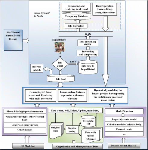
Based on the earlier analysis and considering the scientific objectives of the Chang'e-1 programme and our research about the theory and method of virtual geographic environments (VGEs) (Lin and Gong Citation2002, Lin and Zhu Citation2006, Lin and Batty Citation2008), we propose that a virtual lunar environment platform should support both visualised information sharing and visualised research work. It should be able to present the topographic characteristics of the lunar surface and can also be used to analyse the formation and evolution of the lunar environment. Accordingly, the design of the framework for the virtual lunar environment is shown in . In this framework, strategies for information sharing and 3D visualisation are considered, and process models are added to help further analysis.
Figure 1. Framework of the virtual lunar environment.
3. The implementation strategy of the virtual lunar platform
Based on the framework, a preliminary virtual lunar platform was developed using C++, and the rendering engine was based on an open source 3D engine known as Irrlicht (Irrlicht, Citation2010). Moreover, the development platform is.Net 2010, the Data Server is Dell (TM) PowerEdge (TM) R610 Rack Mount Server, and the Graphical Card is NVIDIA Quadro® FX 4800. The essential implementation strategies are illustrated in the following sections.
3.1. Data processing strategy
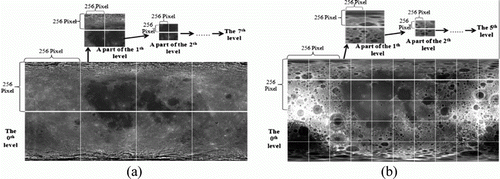
Based on the processed satellite imagery and copious observation data acquired by laser altimeter and supported by the lunar exploration project of China (Ping et al. Citation2009, Cai et al. Citation2010, Li et al. Citation2010), three types of fundamental data are selected for initially platform building, namely (1) the Lunar Base Map of Chang'e-1 (precision of 120 m, and format of .jp2), which employs simple conic projection and covers 180°W to 180°E, and 90°N to 90°S, (2) a digital elevation model (DEM) of the whole moon derived from the Three-line Array Photogrammetric System of Chang'e-1 (precision of 500 m, and format of .jp2), which also employs simple conic projection and covers 180°W to 180°E, and 90°N to 90°S and (3) all the geographic names of the moon. First, the pre-processing of the data is necessary to display images on a spherical lunar surface and to better serve the later data organisation: (1) the Lunar Base Map of Chang'e-1 is corrected with ENVI, and each pixel is projected onto the geodetic coordinate system. Because the resolution of the original image (90987*45510) is not suitable for building the image pyramid, re-sampling of the image is required. The resolution after image resample is 131072(4*256*27)*65536(2*256*27). (2) Using the same strategy to deal with the DEM data of the whole moon, the original resolution of the DEM is 21844*10932; the resolution becomes 81920(10*256*25)*40960(5*256*25) after re-sampling.
In terms of organising the images and DEM, the multi-resolution pyramid approach can not only regulate the data volume by providing suitable resolution data when downloading and transmitting but also avoid unnecessary data access (Camara et al. Citation2008); this approach was employed to compress and partition the entire image and DEM. The details of the data partitioning are illustrated in (a) and (b). As the size of each pyramid tile will be constant (256*256), multi-pixels of the original image need to be merged. Using the satellite image as an example, the merging method is shown in .
| 1. | Calculate the tile's pixel count x(y) in the direction of a row (column), using x=131072/4*2 n , y= 65536/2*2 n , in which n means the nth layer; | ||||
| 2. | Set an array buffer [i, j] to store the pixel of the ith row and jth column of the original image. Array buffer′ [i′, j′] is for storing the pixel of the i′th row and j′th column of the merged image, in which row_num means x/256 and col_num means y/256. The process is provided in Equation (Equation1). | ||||
Figure 2. The compress and partition method for the satellite image and DEM.
After creating multiple resolution pyramid tiles, they are stored using the names X_Y_Z (counting from the left bottom, the tile's column value is represented by X, Y is for row value and Z is for level number). While in terms of the logical organisation, these tiles are indexed by a quad tree so that they can be scheduled effectively (see ). In terms of conversing between the established index and the storage name (X_Y_Z), the conversion strategy is designed as follows:
| 1. | For the tile of the Z level, the Y row and the X column, the index value can be generated according to . | ||||
| 2. | The column number and row number of the upper level can be derived by the following equation: X′ =⌈X/2⌉, Y′=⌈Y/2⌉. The index value of the upper level can be generated according to , and the index value of all levels can be derived by recursion. | ||||
Figure 3. The index naming rule of tiles based on a quad tree.
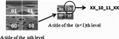
Table 1. The generative rule of tile index.
In terms of the accurate coordinates of the geographic name on the lunar surface, the quad tree of the geographic name can be built using the geodetic coordinates. Thus, the lunar surface geographic name can be organised using the XML technique and indexed by a quad tree.
3.2. Visualisation strategy
The visualisation of massive terrain always requires scheduling the mass images and digital terrain data; a robust strategy of data scheduling and level of detail (LOD) will greatly increase the efficiency of rendering and will promote the response time of the system (Dietrich et al. Citation2007).
3.2.1. Field of vision selection
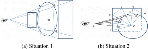
During the rendering process, the visible landscape or objects within the field of vision are significant. Thus, selecting an appropriate field of vision will not only benefit scheduling the required data volume but also increase the rendering efficiency by view clipping and back-face culling (Akenine-Moller and Haines Citation2004). The rendering object in this project is a sphere, which makes the calculation of the vision field different from the one used for rendering flat objects. We designed the following strategy for selecting the vision field:
| 1. | In terms of the view frustum intersecting the sphere, we calculated the vision field by direct secant line. The area covered by the connection of a, b, c, d is the required vision field (a). | ||||
| 2. | When part of the sphere's boundary is within the view frustum, which means part of the view frustum does not intersect with the sphere, we divided the borderline of the zNear plane of the view frustum into segments according to a pre-determined length. The connections of the centre of the sphere and breakpoints make several surfaces; several tangent lines cross the viewpoint and the previous surfaces make some intersection points, the area covered by the connections of these intersection points constitute the field of vision. As shown in (b), the planes of oab, obc, ocd, ode and oef are all generated by connecting the zNear breakpoints and the centre of the sphere. The tangent lines that cross the viewpoint and the previous planes will form intersections (a′, b′, c′, d′, e′) when meeting the sphere; connecting all of the intersections gives the field of vision. | ||||
Figure 4. The strategy for the field of vision selection.
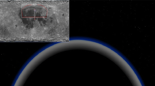
The selected vision field is shown in . The small area covered by red lines within the thumbnail at the top left corner is the vision field of this sphere.
Figure 5. The results of the field of vision selection.
3.2.2. Data scheduling and LOD
Because the platform of the virtual lunar environment is designed on the basis of WAN, various factors such as Internet speed and data volume will be significant when considering the data request and response. A multithreading asynchronous scheduling strategy was employed to maintain the relative independence of the rendering process and data scheduling during the visualisation.
First, the multi-scale body of the virtual moon, which takes the form of a pyramid structure, was built. According to the vision field selection method in Section 3.2.1, the selected tiles of the specific region to be rendered were shaped. Because each tile of the pyramid has accurate geodetic coordinates, according to the area of the tile required to be rendered, the corresponding images and data block of terrain were requested using different threading. Following asynchronous transfer, the images and terrain data were filled, spliced and then rendered in the specific area. shows the multi-resolution tiles of the sphere body, and different resolution images and DEM data were required.
Figure 6. The multi-resolution tiles of the sphere body and date request.
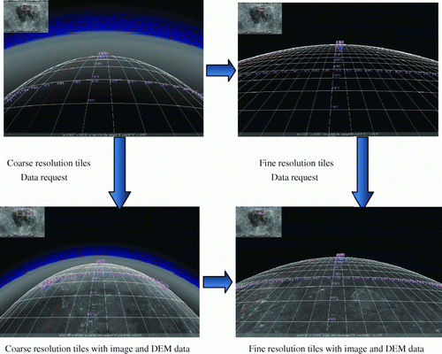
Another issue is how to confirm the exact level of the image and DEM from the database, while these pyramid-like pre-processing data are being requested. In terms of the idea of a clipmap (Tanner et al. Citation1998), the intersection point of the sight line and the sphere is treated as the central point. Areas close to the central point will request the highest resolution (the highest level in the pyramid), and the outer area will receive the lower level tiles. This tile distribution will generate layered, nested, hollow rectangular rings. In this way, all of the invoked images will compose a number of layered, nested, rectangular rings. The advantage of this data scheduling method is that not all data will be requested again while the viewpoint moves. Only the L-area must be focused, and the corresponding data will be invoked again.
3.3. Cache strategy
The cache strategy is another critical method to increase the efficiency of rendering massive terrain and reduce the transmission quantity (Gobbetti et al. Citation2008).
The cache strategy of the virtual lunar environment in this project consists of a memory caching strategy and a local caching strategy. In terms of the data block cached in RAM, we use ‘the life cycle of tile’ to express how long the data block is stored in RAM. We use ‘visitorial popularity’ to represent the frequency of visits to the data block. During the rendering process, the lifespan of the data block stored in RAM will be reduced gradually according to the extension of the rendering time. However, the ‘visitorial popularity’ will increase the lifespan of the data block. The data block will be unloaded from RAM if its lifespan has reduced to a specified amount. We use WorldWind for reference to design the local caching strategy. Downloading the images according to the requirements of the server of the virtual moon and storing them on a local disk enables the cache file to be seen. Moreover, the shared cache technology is also employed so that data will be recalled from other local computers if there is a server problem. Even if the computer is disconnected from the network, local caching images can also be used for offline browsing of the virtual moon.
3.4. Server deployment strategy
The virtual lunar environment platform must be able to allow mass distributed users to simultaneously communicate and share online. The increased virtual scenarios and subsequent users improve the expandability and load capacity of the system critical issues. Consequently, designing the parallel cluster environment-based server architecture and dynamic load balancing strategy of the multi-server are the key issues of server deployment.
3.4.1. Server architecture
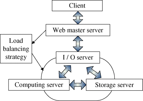
To prevent the server from crashing as a result of mass data transmission and high concurrent In/Out (I/O) visits, we deploy the distributed server cluster hierarchically to relieve the pressure on the server and divide them into I/O Server, Computing Server and Storage Server in terms of their specific task. The I/O Server is responsible for I/O visiting. The Computing Server is in charge of process computation and functions of fundamental analysis, while the Storage Server is used for storing lunar images and other data. The relationship between these servers is shown in .
Figure 7. Server architecture of the virtual lunar environment.
3.4.2. Load balance strategy
The existing algorithms of load balance emphasise on distributing the load to several servers. These algorithms are usually expensive, and using them will influence the interactive performance of the system (Frachtenberg and Schwigeglshohn Citation2008). Wang et al. (Citation2008) introduced a hierarchical iterative algorithm of load balance. With the overload server as the central point, several servers around the central point are hierarchically selected, servers with smaller loads close to the overloaded server are adjusted, and the overload is iteratively diffused from the inside to the outside. The system will reach load balancing after multiple iterative calculations. However, in reality, the load of servers is often deployed according to the geographic location base region-block. While users are browsing the virtual moon, because of the influence of geographic connectivity, the adjacent area will be visited or displayed preferentially over the farther area. Therefore, we modified this algorithm to consider the load conditions combined with geographic connectivity. While diffusing the overload from the inside to the outside, the location marks of the geographic data that were stored in the overloaded server and those that were stored in the nearest less loaded server were estimated. If the location marks of these two servers are regionally neighbours, then the nearest less loaded server will be estimated and adjusted because it may be visited soon. Considering the deployment of geographic data, this modified algorithm performs much better than the original algorithm that only considered the load condition of the servers. The modified algorithm further enhances the practicability of the load balance strategy.
4. Dynamic simulation of the formation of moon craters
The lunar surface is often impacted by meteoroids and small asteroids, which leave craters on the impact area. Those moon craters are of critical importance in studying the formation of the moon, the characteristics of lunar surface and the composition of the moon. To date, the research about moon craters has focused on the formation of moon craters (e.g. Bierhaus et al. Citation2005), the constitution of moon craters (e.g. Grieve et al. 2000) and the composition of moon craters (e.g. Solomon and Toksoz Citation1973, Ouyang 2005), etc. Because it is difficult to acquire material from the lunar surface, research on the dynamic impact process that forms moon craters remains insufficient. Shuvalov and his research team made some in-roads in this field (e.g. Shuvalov and Artemieva Citation2002, Shuvalov and Trubetskaya Citation2008), but the detailed algorithms that they employed for simulating the impact process have yet to be revealed.
The impact force generated by the collision of meteoroids or small asteroid is far greater than the intensity of rocks covering the lunar surface. This impact can be regarded as a super-fast collision process. In terms of the super-fast collision process theory, Kinslow (Citation1970) proposed ‘The law of crater depth models’, which illustrated the relationships between crater depth and projectile speed, projectile density, target density, intensity and acoustic velocity and projectile-target geometry (e.g. the calibre of the projectile). This law is expressed as Equation (Equation2).
Within this model, c, a 1, a 2, a 3 are non-dimensional constants that will change with the selected materials and the range of impact speed. In their empirical calculation, Sedgwick et al. (Citation1978) proposed that c=0.482, a 1=0.537, a 2=0.47 and a 3=0.106. p c is the crater depth, v is the projectile speed, d p and ρ p are the diameter and density of the projectile, respectively, and ρ t ,Y t and c t are the density, intensity, and the acoustic velocity of the target, respectively. In terms of the shape of the craters, Pike (Citation1974) proposed an empirical formula by measuring and calculating a large number of moon craters. The diameter of the craters can be back calculated using Equations (Equation3) and (Equation4).
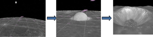
Based on the earlier research, we begin to study the preliminary, dynamic impact process of moon craters. By integrating the dynamic impact model and lunar surface data, the formation of moon craters can be simulated dynamically. The composition of the lunar mare is largely basalt, and the highland is composed of anorthosite. Based on the density and intensity of these two types of rock and combining the theoretic formula of super-fast collision process, we dynamically simulate the impact process of meteoroids crashing into the moon. The results are demonstrated in .
Figure 8. Dynamic simulation of the formation of moon craters.
5. Conclusion and future work
Based on the satellite images of Chang'e-1, the WAN-based virtual lunar environment was developed; the framework of the platform was proposed; and data processing, organising methods and key technologies such as data scheduling strategy, LOD strategy and cache strategy were used to effectively rendering mass data of the lunar surface. Emphasis was given to the dynamic simulation of the formation of moon craters based on the theory of a super-fast collision process, which will lay the practical and theoretical foundation for the second stage mission of China's lunar exploration project (namely landing on the lunar surface).
However, this project is still at the initial stage. Further emphasis will be given to the following issues: (1) the strategies of data scheduling and organising at the present stage are designed on the basis of related technologies of Google Earth and WorldWind technologies. Although the efficiency can meet the project requirements, several technologies need to be improved to further increase the efficiency of the system. These technologies include building a multilevel index and data compression for transmission. (2) Further exploration of the super-fast collision experiment is needed. The impact process was simulated based on a theoretical formula. We will pursue essential practical experiments using basalt (the major components of lunar mare), anorthosite (the major components of lunar highland) and man-made lunar soil (Zheng et al. Citation2009) to more accurately simulate the impact process of meteoroids crashing into the moon and increase the reliability of these experiments. (3) Several additional functions that support collaborative research and information sharing with the public and researchers should be further developed as long as the specific requirements are defined and the corresponding functions are customised. These developing functions will promote the popularisation and application of the well-developed platform of the virtual lunar environment.
Notes on contributors
Dr. Min Chen received the PhD in Cartography and geography information system from the Key Laboratory of Virtual Geographic Environment (Ministry of Chinese Education), Nanjing Normal University in 2009, and now is a post-doctoral fellow of the Institute of Space and Earth Information Science, the Chinese University of Hong Kong. His research interests are Virtual Geographical Environments (VGEs) and Spatially Integrated Humanities and Social Science.
Prof. Hui Lin is now a director of the Institute of Space and Earth Information and Science, Chinese University of Hong Kong. He was elected in 1995 as academician of the International Eurasian Academy of Sciences. His current research projects include Virtual Geographic Environments, Cloudy and Rainy Environmental Remote Sensing, Megalopolitan GIS and Spatially Integrated Humanities and Social Science.
Dr. Yongning Wen received the PhD in Cartography and geography information system from the Key Laboratory of Virtual Geographic Environment (Ministry of Chinese Education), Nanjing Normal University in 2009, and now is a lecturer of the Key Laboratory of Virtual Geographic Environment (Ministry of Chinese Education). His research interests are Virtual Geographical Environments (VGEs).
Mr. Li He received the Master of Science degree in Earth System Science at the Institute of Space and Earth Information Science (ISEIS) in the Chinese University of Hong Kong, and now pursuing the postgraduate degree at the Key Laboratory of Virtual Geographic Environment (Ministry of Chinese Education) in Nanjing Normal University. His research interest covers Virtual Geographic Environment (VGE).
Dr. Mingyuan Hu received the PhD in Photogrammetry and Remote Sensing from Wuhan University, China in 2008, and now is a postdoctoral fellow of the Institute of Space and Earth Information Science, the Chinese University of Hong Kong. His research interests are Virtual Geographical Environments (VGEs).
Acknowledgements
The work described in this article was supported by the Key Program of National Natural Science Foundation of China (grant no. 40730527), the National High Technology Research and Development Program of China (key ‘863’ no. 2010AA122202), the National Natural Science Foundation of China (grant no. 41001223) and the Direct Grant of The Chinese University of Hong Kong (grant no. 2021064). We also appreciate the detailed suggestions and comments from the editor and the anonymous reviewers.
Related Research Data
References
- Akenine-Moller , T. and Haines , E. 2004 . Real-time rendering , 2nd ed , Natick : AK Peters Ltd .
- Annoni , A. 2011 . A European perspective on Digital Earth . International Journal of Digital Earth , 4 ( 4 ) : 271 – 284 .
- Bell , D.G. , et al. , 2007 . NASA world wind: open source GIS for mission operations [online]. Available from: http://www.riacs.edu/research/projects/worldwind/IEEE_1048_WorldWind_Final.pdf [Accessed 13 September 2011] .
- Bierhaus , E.B. , Chapman , C.R. and Merline , W.J. 2005 . Secondary craters on Europa and implications for cratered surfaces . Nature , 437 ( 20 ) : 1125 – 1127 .
- Camara , G. 2008 . TerraLib: an open source GIS library for large-scale environmental and socio-economic applications . Advances in Geographic Information Science , 2 : 247 – 270 .
- Cai , Z.C. 2010 . Lunar digital elevation model and elevation distribution model based on Chang'e-1 LAM data . Science China Technological Sciences , 53 ( 9 ) : 2558 – 2568 .
- Compton , W.D. , 1989 . Where no man has gone before: a history of Apollo lunar exploration missions [online]. Available from: http://www.spacearium.com/filemgmt_data/files/SP-4214.pdf [Accessed 6 May 2011] .
- Dietrich , A. , Gobbetti , E. , and Yoon , S.E. , 2007 . Massive-model rendering techniques: a tutorial . IEEE Computer Graphics , 27 (6) , 20 – 34 .
- Foresman , T.W. 2008 . Evolution and implementation of the Digital Earth vision, technology and society . International Journal of Digital Earth , 1 ( 1 ) : 4 – 16 .
- Frachtenberg , E. and Schwigeglshohn , U. 2008 . New challenges of parallel job scheduling . Lecture Notes in Computer Science , 4942 : 1 – 23 .
- Galimov , E.M. 1999 . The Russian Lunar Exploration Project . Solar System Research , 33 : 327
- Gobbetti , E. , Kasik , D. , and Yoon , S.E. , 2008 . Technical strategies for massive model visualization . Proceeding in ACM SIGGRAPH ASIA 2008 courses [online]. Available from: http://sglab.kaist.ac.kr/~sungeui/paper/spm08_symp.pdf [Accessed 13 September 2011] .
- Guo , H.D. , Fan , X. and Wang , C. 2009 . A digital earth prototype system: DEPS/CAS . International Journal of Digital Earth , 2 ( 1 ) : 3 – 15 .
- Guo , H.D. , Liu , Z. and Zhu , L.W. 2010 . Digital Earth: decadal experiences and some thoughts . International Journal of Digital Earth , 3 ( 1 ) : 31 – 46 .
- Hargitai , H.I. , et al. , 2001–2006 . Maps of Mars, Venus, Mercury, Moon, Phobos and Deimos , Central Europena . Available from: http://www.harmsy.freeuk.com/phobos.html [Accessed 16 October 2011] .
- Harvey , B. 2007 . Soviet and Russian lunar exploration , UK : Praxis Publishing Ltd .
- Introduction of Irrlicht SDK 1.7.2 , 2010 . Available from: http://irrlicht.sourceforge.net/downloads.html [Accessed 16 October 2011] .
- Kinslow , R. 1970 . High-velocity impact phenomena , New York and London : Academic Press .
- Kirk , R.L. 2009 . Cartography for lunar exploration: 2008 status and mission plans . The International Archives of the Photogrammetry, Remote Sensing and Spatial Information Sciences , XXXVII (B4) : 1473 – 1490 .
- Li , C.L. 2010 . The global image of the moon by the Chang'e-1: data processing and lunar cartography . Science China Earth Sciences , 40 ( 3 ) : 294 – 306 .
- Lin , H. and Batty , M. 2008 . “ Virtual geographic environments: a primer ” . In Virtual geographic environments , Edited by: Lin , H. and Batty , M. 1 – 10 . Beijing : Science Press .
- Lin , H. and Gong , J.H. , 2002 . On virtual geographic environments . In : Editorial Dept. of Acta Grod. Cartog, eds. Selected papers for English edition-Acta Geodaetica et Cartographic Sinica . Beijing : the Publishing House of Surveying and Mapping , 90 – 95 .
- Lin , H. and Zhu , Q. 2006 . “ Virtual geographic environments ” . In Large-scale 3D data integration: challenges and opportunities , Edited by: Zlatanova , S. and Prosperi , D. 211 – 230 . Boca Raton , FL : Taylor & Francis .
- Lin , H. 2010 . A grid-based collaborative virtual geographic environment for the planning of silt dam systems . International Journal of Geographical Information Science , 24 ( 4 ) : 607 – 621 .
- Marais , D.J.D. 2008 . The NASA astrobiology roadmap . Astrobiology , 8 ( 4 ) : 715 – 730 .
- NAOC . 2007 . Available from: http://moon.bao.ac.cn/templates/T_yestem_articelcontent/index.aspx?nodeid=76 [Accessed 12 May 2011] .
- Ouyang , Z.Y. 2005 . Introduction to lunar science , Beijing : China Aerospace Press .
- Pike , R.J. 1974 . Depth/diameter relations of fresh lunar craters-revision from spacecraft data . Geophysical Research Letters , 1 : 291 – 294 .
- Ping , J.S. 2009 . Lunar topographic model CLTM-s01 from Chang'e-1 laser altimeter . Science in China Series G: Physics Mechanics and Astronomy , 52 ( 7 ) : 1105 – 1114 .
- Ruberg , L , et al. , 2009 . MoonWorld: virtual fieldwork in second life [online] . 40th Lunar and planetary science conference . Available from: http://www.lpi.usra.edu/meetings/lpsc2009/pdf/2229.pdf [Accessed 10 May 2011] .
- Sasaki , S. 2002 . Scientific exploration of lunar surface using a rover in Japanese future lunar mission . Advances in Space Research , 30 ( 8 ) : 1921 – 1926 .
- Seamans , R.C. , 2005 . Project Apollo: the tough decisions [online]. Available from: http://history.nasa.gov/monograph37.pdf [Accessed 14 September 2011] .
- Sedgwick , R.T. 1978 . Numerical investigations in penetration mechanics . International Journal of Engineering Science , 16 ( 11 ) : 859 – 869 .
- Shuvalov , V.V. and Artemieva , N.A. 2002 . Numerical modeling of Tunguska-like impacts . Planetary and Space Science , 50 : 181 – 192 .
- Shuvalov , V.V. and Trubetskaya , I.A. 2008 . Numerical simulation of the LCROSS impact experiment . Solar System Research , 42 ( 1 ) : 1 – 7 .
- Solomon , S.C. and Toksoz , M.N. 1973 . Internal constitution and evolution of the moon . Physics of the Earth and Planetary Interiors , 7 ( 1 ) : 15 – 38 .
- Takano , Y. , Takizawa , Y. and Sasaki , S. 2005 . The SELENE project and Japanese future lunar exploration . Acta Astronautica , 57 ( 2–8 ) : 112 – 115 .
- Tanner , C.C. , Migdal , C.J. , and Jones , M.T. , 1998 . The clipmap: a virtual mipmap [online]. Proceedings of the 25th annual conference on computer graphics and interactive techniques . Available from: http://www.cs.virginia.edu/~gfx/Courses/2002/BigData/papers/Texturing/Clipmap.pdf [Accessed 14 September 2011] .
- Wang , S.F. , Zhou , Z. and Wu , W. 2008 . A layered iterative load balancing algorithm for distributed virtual environment . Journal of Software , 19 ( 9 ) : 2471 – 2482 .
- Wood , C.A. , et al. , 2010 . MoonWorld: implementation of virtual lunar exploration [online] . 41st Lunar and planetary science conference . Available from: http://www.lpi.usra.edu/meetings/lpsc2010/pdf/1439.pdf [Accessed 10 May 2011] .
- Yang , Y.C. 2008 . “ A virtual simulation environment for Lunar Rover: framework and key technologies ” . In International Journal of Advanced Robotic Systems 201 – 208 .
- Zheng , Y.C. 2008 . China's Lunar Exploration Program: present and future . Planetary and Space Science , 56 : 881 – 886 .
- Zheng , Y.C. 2009 . CAS-1 lunar soil simulant . Advances in Space Research , 43 ( 3 ) : 448 – 454 .
- Zhou , Y. , et al. , 2010 . Lunar geomorphy 3D visualization method . In : W. Wagner and B. Székely , ISPRS TC VII symposium – 100 Years ISPRS, IAPRS, Vol. XXXVIII, Part 7B , 5–7 July , Vienna , Austria , 674 – 679 .