Abstract
There has been a worldwide revolution in geoscientific data availability and access. An effectively infinite and instantaneous free access to geoscientific data from the World Wide System of Geoscience Data Centers and Virtual Observatories is available. In addition, national databanks and commercially available large exploration data-sets also exist. These distributed data resources impose challenges for the future to move toward their objective integration and visualization to discover new knowledge. Such advancements can facilitate meaningful interpretations and decision-making for the benefit of society at global and local scales. This article presents the Digital Earth initiative at a national level to address multiple domains, such as effective management of natural resources, interactive planning of exploration activities and monitoring, mapping and mitigation of natural hazards. It discusses a distributed geospatial data infrastructure and its importance in geoscientific data integration for efficient and interactive data retrieval, analysis and visualization. Some examples are presented to demonstrate the advantages of integrated visualization in geoscientific analysis.
1. Introduction
Geosciences are becoming increasingly flooded with large quantities of data which make their analysis and visualization as one of the most compute-intensive as well as graphics-intensive applications. Several global data resources are available in the public domain such as Digital Elevation Models (DEMs) (USGS Citation1996a, GLOBE Task Team Citation1999, Farr et al. Citation2007), streams and drainage basin databases (USGS Citation1996b), earthquake catalogs (NEIC Citation1966), satellite imagery (NASA Citation2000), Earth gravitational models (Lemoine et al. Citation1998), and Moderate Resolution Imaging Spectroradiometer (MODIS) (NASA Citation1999 and 2002). Similarly a number of national databanks containing cultural information and commercial exploration and mining databases of gravity, magnetic, and seismic data are also available to the scientific community. Geoscientific studies usually demand integrated analysis and visualization of multiple types of data-sets to complement the results for a more reliable interpretation. It is necessary to find effective ways to combine such exceedingly huge amounts of information. Without the availability of appropriate tools and technology, it becomes difficult for geoscientists to manage and correlate such large and complex data-sets. Therefore, these distributed and heterogeneous data resources which are available in different formats, geodetic projection systems and inherent resolutions, must be spatially integrated into georeferenced databases for analysis and visualization.
The Digital Earth (DE) initiative is based on Geospatial Cyberinfrastructure (GCI) which supports integration, storage, and efficient access to georeferenced data resources along with a set of processing, analysis and visualization tools to generate useful information for decision support. Foresman (Citation2008), Ehlers (Citation2008), and Guo et al. (Citation2010) have discussed in detail the historic background, evolution, and development of DE and its impact on society. Yang et al. (Citation2010) have discussed the development and future of GCI and consider it as a backbone of DE. Nativi and Domenico (Citation2009) and CitationPercivall (2010) have focused on interoperability issues of geospatial data, while Yang et al. (Citation2008) have discussed integration of distributed geospatial resources for DE. Visualization is considered as the most important aspect of DE. In the past several efforts have been carried out based on techniques available at that time that supported integrated visualization of geoscientific data. Some of these techniques were: Freeman et al. (Citation1983), Chung (Citation1983), Rhyne et al. (Citation1994), Rhyne (Citation1997), Lin et al. (Citation1999), McCarthy and Graniero (Citation2006), and Lloret et al. (Citation2008). The Earth observation systems are a major source of input to the DE (Guo Citation1999). Using such vast data resources DE and supporting infrastructure have successfully addressed a number of domains (Shupeng and van Genderen Citation2008, Yang et al. Citation2011).
The DE vision has also been implemented at a regional level, such as digital country (Chen and Wu Citation2003, Thompson et al. Citation2008). This article discusses DE initiatives for Pakistan. A geospatial infrastructure is presented which integrates a variety of geoscientific data-sets existing in different formats, projections and resolutions, and provides a graphics front-end for interactive query, retrieval, analysis, and visualization of various combinations of these data-sets to successfully address multiple domains.
2. Spatial data infrastructure for data integration
Data integration refers to storage and georeferencing of multiple types of heterogeneous data-sets into an array of databases developed under a distributed geospatial data infrastructure. The system used for integration, analysis, and visualization of geospatial data consists of three main components: an array of databases at the backend, geobrowser (Foresman Citation2004, Goodchild Citation2008) a specialized form of geographic information systems (GIS) at the front-end, and several geoscientific applications and services available to the geobrowser for analysis () (Khan Citation2000). Two middleware components are also part of the system. The gridded data-sets are contoured or rendered as color maps for display in the geobrowser. Similarly, the data from database tables undergoes graphics rendering according to user-defined templates. This spatial data infrastructure supports storage of data-sets in a number of forms which include: relational database tables, indexed files, digitized vector layers, searchable binary grids, and multi-resolution imagery as quadtree tiles (Khan et al. Citation2008). Each data-set is stored in one of these forms, depending on its data structure. These data resources are integrated in centralized as well as distributed databases. In addition, the system also supports on the fly integration by directly accessing data from the World Data Centers. The main steps that have been followed during data integration are: (1) initial data quality control; (2) conversion of data-sets from any non-standard formats into the industry standard formats used by the system, using output input language (OIL) format engine (Khan et al. Citation2010); (3) transformation of data-sets into Universal Transverse Mercator (UTM) projection with World Geodetic System (WGS-84) datum; and (4) validation and storage of data. The above-mentioned preprocessing steps are usually applied to new data-sets collected at a national level. Data-sets from World Data Centers are preprocessed and therefore are imported directly. The final databank consists of an array of distributed databases, georeferenced in a single geodetic projection and datum.
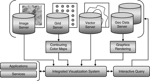
The geobrowser supports visual actions such as pointing data objects on a map and click-and-drag to select a geographic area of interest. These actions trigger events which are used by an interactive query component to generate data retrieval queries in the form of structured query language (SQL) for relational databases or index pointers for image and gridded data servers. In this way multiple distributed databases can be interactively queried to retrieve data. The geobrowser also allows registry of specialized geoscientific applications and services for data processing and analysis. The retrieved data-sets as well as their processed and analyzed results are displayed as separate GIS layers on the geobrowser interface. Thus, the geobrowser integrates data-sets as well as processes operating on them under a single interface (Khan et al. Citation2009).
This distributed geospatial data infrastructure is used to compile a complete digital databank of Pakistan which consists of the following: (1) imagery; (2) cultural data such as cities, roads, administrative boundaries, and rivers; (3) DEMs; (4) drainage patterns; (5) structural faults; (6) earthquakes epicenters; (7) gravity and magnetic grids; and (8) exploration data covering lease concessions, seismic lines and wells. A combination of these data resources along with processing and analysis tools can be used for different scientific and application needs.
3. Analyses and visualization
The Earth is a dynamic planet with changes taking place due to natural and human activities. The main aim of integrated analysis and visualization is to access, process, map, and simulate vast amounts of spatio-temporal data to monitor the change and generate decision supporting information. The overlay of multiple layers of data on the map also assists in understanding the spatial correlations between various data-sets. The geoscientist integrates the data mentally and develops the interpretations. The geobrowser is a highly dynamic visualization system in which the individual layers can be switched On or Off, projection system can be changed on the fly according to the user requirements, and imagery resolution can also be changed. In addition contour intervals, color filters and transparency of overlaid imagery, and color maps can be altered.
Various data layers that can be displayed in the geobrowser are imagery, color maps or shaded relief of DEM, cultural information comprising of administrative boundaries, cities, roads and rivers, earthquakes epicenters and seismicity maps, structural faults, drainage patterns and hydrological data, contours generated from gravity, magnetic and other types of gridded data-sets, seismic lines, wells, and lease concessions.
Finally, some examples are presented to demonstrate the effective use of integrated visualization in spatial correlation, interpretation, and interactive survey planning. In all these examples data-sets retrieved from selected databases are integrated for visualization, keeping in mind some specific purpose. Each of these examples is illustrated along with a short description of the data-sets used, any processes applied on them, and the information and help they provide in interpretation through integrated visualization. shows satellite imagery along with elevation and gravity contours. A close match between topographic features visible in the imagery and their elevation contours can be clearly observed. The figure also demonstrates the effects of topography on the gravity anomaly. Such integrated visualization facilitates better interpretation by analyzing the spatial correlations between various data components. The data are analyzed and gravity lows are used to demarcate a sedimentary basin which is considered as a potential zone for hydrocarbon exploration.
![Figure 2. Satellite imagery [Landsat 7, bands 2, 4, and 7, Source: National Aeronautics and Space Administration (NASA)] overlaid with colored contours of topography [30 arc-seconds Shuttle Radar Topography Mission (SRTM30), Source: National Geospatial-Intelligence Agency (NGA) and NASA] and black contours of gravity [Source: Pakistan Geophysical Database]. A sedimentary basin was demarcated with an orange line by identifying the zone of low gravity.](/cms/asset/ba7037c3-e965-46c4-837c-c1f1d6f415e8/tjde_a_638990_f0002_oc.jpg)
shows four data-sets retrieved and displayed from the databank for a given geographic area of interest. These include satellite imagery, lease concessions, seismic lines, and wells. Their integrated visualization highlights the exploration activity that has been carried out along with zones of successful wells. This information is used as decision support to identify new areas for planning seismic exploration. A highly interactive and specialized seismic survey design application, linked with the geobrowser, is used to plan a new 3D seismic survey grid over these displayed data layers. It can be seen that seismic pickets in the 3D grid have been moved sideways due to a water body obstruction visible in the imagery. Thus using such integrated visualization real ground situations are taken into account during the analysis and survey design process.
![Figure 3. Satellite Imagery [Landsat 7, bands 2, 4, and 7, Source: National Aeronautics and Space Administration (NASA)] with three exploration data layers; lease concessions polygons, seismic lines (yellow lines with purple pickets) and wells (red circles) [Source: Pakistan Exploration Database]. A 3D seismic survey grid was planned in the lower-left area using interactive seismic survey design tools.](/cms/asset/184363c5-6abb-4c72-8e7a-9b5545ce345c/tjde_a_638990_f0003_oc.jpg)
A tectonic map of Pakistan showing spatial relationship between topographic features, structural faults and concentration of earthquake epicenters is given in . The earthquake data are regularly updated from the worldwide available earthquake catalogs. A seismicity analysis application uses the faults and earthquakes data and generates a seismic hazard zones map, as shown by shaded colors in . This map truly represents the spirit of DE, instead of a static paper map, a completely dynamic seismic hazard zones map is produced which keeps on changing with the changing trend of earthquake patterns.
![Figure 4. Shaded relief map generated from Digital Elevation Model [3 arc-seconds Shuttle Radar Topography Mission (SRTM3), Source: National Geospatial-Intelligence Agency (NGA) and National Aeronautics and Space Administration (NASA)] overlaid with structural faults (pink lines) [Source: Pakistan Geophysical Database], earthquake epicenters (green, blue, and red dots) [Source: National Earthquake Information Center (NEIC), US Geological Survey] and administrative boundaries of Pakistan (yellow). A seismic hazard zones map was generated by analyzing the faults and earthquakes patterns. It highlights four seismic risk zones; minor (green), minor to moderate (blue), moderate (orange) and severe (red).](/cms/asset/fb6b8f0d-4017-49e1-988e-60db4828cb4f/tjde_a_638990_f0004_oc.jpg)
Finally, shows a topographic map of Pakistan and surrounding regions, generated from DEM. The DEM data are processed to generate a drainage pattern which is overlaid on topography along with a network of rivers. This integrated information is further used for hydrogeologic analysis.
![Figure 5. (Upper-left) Colored topographic map with administrative boundaries of Pakistan (yellow). (Lower-right) The same map with rivers and a superimposed partially transparent image of drainage pattern, computed from Digital Elevation Model [3 arc-seconds Shuttle Radar Topography Mission (SRTM3), Source: National Geospatial-Intelligence Agency (NGA) and National Aeronautics and Space Administration (NASA)].](/cms/asset/bdb6c960-d3cb-4b14-802d-8c0868801604/tjde_a_638990_f0005_oc.jpg)
The above examples demonstrate visual integration of selected data layers which help improve the analysis leading to more meaningful interpretations. Integrated visualization of existing data-sets can also be useful in designing and planning new surveys. It has been found that such visualization provides new insights into the linkages between various data-sets.
4. Conclusions
The main aim of DE is integration and visualization of geospatial data from multiple domains to better understand the processes and changes taking place on earth. This acts as an effective decision support vehicle for improved management, exploitation, and utilization of natural resources and efficient monitoring and improved prediction of climate, weather, and natural hazards. A country level DE initiatives are discussed which highlight the importance of integrated visualization for analysis and interpretation of geoscientific data. A unified platform for interactive and efficient query, retrieval, processing, analysis, and visualization of multiple geoscientific data-sets is presented. It has been found that this approach saves a lot of time consumed in mining, formatting, converting, and loading heterogeneous data-sets into the system for visualization, and helps the geoscientists and decision-makers in integrated analysis and interpretation of these data-sets.
References
- Chen, J. and Wu, L., 2003. Geospatial fundamental framework of digital China. Beijing: China Science Press.
- Chung, C.F., 1983. SIMSAG: integrated computer system for use in evaluation of mineral and energy resources. Mathematical Geosciences, 15 (1), 47–58.
- Ehlers, M., 2008. Geoinformatics and digital earth initiatives: a German perspective. International Journal of Digital Earth, 1 (1), 17–30. doi:10.1080/17538940701781975
- Farr, T.G., et al. 2007. The shuttle radar topography mission. Reviews of Geophysics, 45: RG2004. doi:10.1029/2005RG000183
- Foresman, T.W., 2004. Digital earth visualization and web-interface capabilities utilizing 3-D geobrowser technology. Proceedings of the 20th ISPRS Congress, 12–23 July 2004, Istanbul, Turkey, 885–888.
- Foresman, T.W., 2008. Evolution and implementation of the Digital Earth vision, technology and society. International Journal of Digital Earth, 1 (1), 4–16. doi:10.1080/17538940701782502
- Freeman, S.B., Bolivar, S.L., and Weaver, T.A., 1983. Display techniques for integrated data sets. Computers & Geosciences, 9 (1), 59–64.
- GLOBE Task Team and others [Hastings, David A., Paula K. Dunbar, Gerald M. Elphingstone, Mark Bootz, Hiroshi Murakami, Hiroshi Maruyama, Hiroshi Masaharu, Peter Holland, John Payne, Nevin A. Bryant, Thomas L. Logan, J.P. Muller, Gunter Schreier, and John S. MacDonald, eds., 1999. The Global Land One-kilometer Base Elevation (GLOBE) Digital Elevation Model, Version 1.0. National Oceanic and Atmospheric Administration, National Geophysical Data Center, 325 Broadway, Boulder, Colorado 80305-3328, USA. Available from: http://www.ngdc.noaa.gov/mgg/topo/globe.html [Accessed 30 September 2011].
- Goodchild, M.F., 2008. The use cases of digital earth. International Journal of Digital Earth, 1 (1), 31–42. doi:10.1080/17538940701782528
- Guo, H.D., 1999. Earth observation and Digital Earth. Beijing: Chinese Science Press.
- Guo, H.D., Liu, Z., and Zhu, L.W., 2010. Digital Earth: decadal experiences and some thoughts. International Journal of Digital Earth, 3 (1), 31–46. doi:10.1080/17538941003622602
- Khan, K.A., 2000. Integrated geo systems – a computational environment for integrated management, analysis and presentation of petroleum industry data. In: T.C. Coburn and J.M. Yarus, eds. Geographic information systems in petroleum exploration and development. Tulsa, OK: American Association of Petroleum Geologists. AAPG Book on Computers in Geology, 215–226.
- Khan, K.A., et al., 2008. Development of a projection independent multi-resolution imagery tiles architecture for compiling an image database of Pakistan. Proceedings of 2nd International Conference on Advances in Space Technologies, 29–30 November 2008, Islamabad, Pakistan, 164–170. doi:10.1109/ICAST.2008.4747706
- Khan, K.A., Akhter, G., and Ahmad, Z., 2009. The real meaning of geoscience data and process integration. Proceedings of IAMG International Conference, Computational Methods for Earth, Energy and Environmental Sciences, 23–29 August 2009. Stanford University, CA, USA.
- Khan, K.A., Akhter, G., and Ahmad, Z., 2010. OIL – Output input language for data connectivity between geoscientific software applications. Computers & Geosciences, 36 (5), 687–697. doi:10.1016/j.cageo.2009.09.005
- Lemoine, F.G., et al., 1998. The Development of the Joint NASA GSFC and NIMA Geopotential Model EGM96, NASA Goddard Space Flight Center, Greenbelt, Maryland 20771, USA. Available from: http://cddis.nasa.gov/926/egm96/egm96.html [Accessed 30 September 2011].
- Lin, H., Gong, J., and Wang, F., 1999. Web-based three-dimensional geo-referenced visualization. Computers & Geosciences, 25 (10), 1177–1185.
- Lloret, J.R., et al., 2008. 3D visualizations in simulations of future land use: exploring the possibilities of new, standard visualization tools. International Journal of Digital Earth, 1 (1), 148–154. doi:10.1080/17538940701782718
- McCarthy, J.D. and Graniero, P.A., 2006. A GIS-based borehole data management and 3D visualization system. Computers & Geosciences, 32 (10), 1699–1708. doi:10.1016/j.cageo.2006.03.006
- NASA, 1999 and 2002. Moderate Resolution Imaging Spectroradiometer (MODIS) instrument aboard Terra (EOS AM) and Aqua (EOS PM) satellites, Goddard Space Flight Center, National Aeronautics and Space Administration, USA. Available from: http://modis.gsfc.nasa.gov/data/ [Accessed 30 September 2011].
- NASA, 2000. GeoCover circa 2000 Coverage by Landsat-7 – a Landsat series satellite, John C. Stennis Space Center, National Aeronautics and Space Administration, USA. Available from: http://zulu.ssc.nasa.gov/mrsid/ [Accessed 30 September 2011].
- Nativi, S. and Domenico, B., 2009. Enabling interoperability for Digital Earth: earth Science coverage access services. International Journal of Digital Earth, 2 (Suppl. 1), 79–104. doi:10.1080/17538940902866179
- NEIC, 1966. Global Earthquake Catalog, National Earthquake Information Center, US Geological Survey, USA. Available from: http://earthquake.usgs.gov/regional/neic/ [Accessed 30 September 2011].
- Percivall, G., 2010. The application of open standards to enhance the interoperability of geoscience information. International Journal of Digital Earth, 3 (1), 14–30. doi:10.1080/17538941003792751
- Rhyne, T.M., et al., 1994. Visualization and geographic information system integration: what are the needs and requirements, if any? IEEE Visualization 94 Proceedings, 17–21 October 1994, Washington, DC, USA, 400–403.
- Rhyne, T.M., 1997. Going virtual with geographic information and scientific visualization. Computers & Geosciences, 23 (4), 489–491.
- Shupeng, C. and van Genderen, J., 2008. Digital Earth in support of global change research. International Journal of Digital Earth, 1 (1), 43–65. doi:10.1080/17538940701782510
- Thompson, B., et al., 2008. Virtual Australia: its key elements – know, think, communicate. International Journal of Digital Earth, 1 (1), 66–87. doi:10.1080/17538940701782551
- USGS, 1996a. GTOPO30 – Global digital elevation model (DEM), Center for Earth Resources Observation and Science (EROS), US Geological Survey, USA. Available from: http://eros.usgs.gov/#/Find_Data/Products_and_Data_Available/gtopo30_info [Accessed 30 September 2011].
- USGS, 1996b. HYDRO1k – Elevation Derivative Hydrologic Database, Center for Earth Resources Observation and Science (EROS), US Geological Survey, USA. Available from: http://eros.usgs.gov/#Find_Data/Products_and_Data_Available/gtopo30/hydro [Accessed 30 September 2011].
- Yang, C., et al., 2008. Distributed geospatial information processing: sharing distributed geospatial resources to support Digital Earth. International Journal of Digital Earth, 1 (3), 259–278. doi:10.1080/17538940802037954
- Yang, C., et al., 2010. Geospatial cyberinfrastructure: past, present and future. Computers. Environment and Urban Systems, 34 (4), 264–277.
- Yang, C., et al., 2011. Spatial computing-using spatial principles to optimize distributed computing for enabling physical science discoveries. Proceeding of National Academy of Sciences, 108 (14), 5498–5503.