Abstract
Digital Earth is an interdisciplinary field involving space technology, information technology, and geoscience. This article introduces the land observation satellite system of China and discusses the requirements for satellite payloads in terms of spatial, temporal, and spectral resolution to establish a Digital Earth. The applications of land satellites under the framework of Digital Earth are introduced from the perspectives of data support, special subject services, and integrated information services. It is concluded that China's land observation satellites and ground processing systems will be fundamental components of the Digital Earth system, in which satellite data and their derived information will serve as the principal information source and greatly promote applications of Digital Earth.
1. Introduction
Digital Earth is a three-dimensional depiction of the Earth with massive amounts of geological and multiresolution data (Gore Citation1998). Essentially, it is a digital representation of the real Earth and its related phenomena. It is a public-oriented, open system based on the Internet and spatial data, and characterized by virtual reality technology (Goodchild Citation1999, Xu Citation2000, Craglia et al. Citation2008, Guo et al. Citation2010). Digital Earth is spatially referenced and interconnected with the world's digital knowledge archives. It is meant to establish a unified model to quickly and completely understand macro and micro surface features on the Earth (Li et al. Citation2010). Digital Earth can not only bring remote sensing data into full play but also offer us a new perspective of the planet we are living on.
Today, China possesses several land satellite observation systems, including the ‘ZY(Ziyuan)’ earth resource satellite series and the small satellite constellation for environment and disaster monitoring and forecasting. Moderate- and high-resolution remote sensing data can be easily obtained from these satellites. Considerable progress in China's satellite payload technology has been made since the last decade. High resolution and ultra high resolution have become the new goal for the development of satellite spatial resolution. Temporal resolution has been gradually improved, and the revisit rate of satellite constellations can be less than 2 days. Different spectral resolutions (multispectral and hyperspectral) have been successfully implemented in satellite sensors, covering the full spectral range from visible to microwave wavelengths.
Earth observation data are an important basis for macro-level decision-making for national issues, such as public security, agriculture, disaster prevention, resource development, and environmental monitoring. It is also a fundamental strategic resource that is indispensable in the construction of future digital cities and Digital Earth. Therefore, China's satellite observation system and its extensive image information can contribute to the construction of a Digital Earth system in the future.
2. The payload systems of China's land observation satellites
2.1. Land observation satellites in China
China now possesses a well-functioning land observation satellite system composed of the ‘ZY(Ziyuan)’ earth resource satellite series and the small satellite constellation for environment and disaster monitoring and forecasting, and the Beijing No. 1 small satellite, as shown in .
Figure 1. The system of land observation satellites in China.
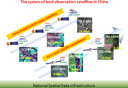
The series of China–Brazil Earth Resources Satellites (CBERS) is being jointly developed by China and Brazil for Earth observation (Chen and Chen Citation2001). Up to now, three satellites have been launched, namely CBERS-01, CBERS-02, and CBERS-02B. CBERS-01 and CBERS-02 were successfully launched in October 1999 and September 2007, respectively. Both satellites were equipped with a wide field imager (WFI) camera, a medium resolution camera (CCD), and an infrared multispectral scanner (IRMSS) camera. CBERS-02B was successfully launched in September 2007 with a new high-resolution camera (HR). Succeeding satellites, CBERS-03 and CBERS-04, are to be launched on schedule to keep the continuity of sensors’ types and parameters while improving image quality and resolution.
The ZY-3 satellite is China's first civilian high-resolution stereo mapping satellite. It will fill a gap in civilian surveying and provide a stable and reliable data source for national satellite surveying and mapping. This satellite will be equipped with three-line array stereoscopic mapping cameras with a spatial resolution less than 4 meters, a panchromatic TDI CCD camera with a resolution less than 2.5 meters, and a CCD camera with a resolution less than 10 meters.
The environment satellites, HJ-1A and HJ-1B, were launched in September 2008 on top of one rocket. The payloads onboard are multispectral CCD cameras on both HJ-1A and HJ-1B, a hyperspectral imager (HJ-1A) and an infrared camera (HJ-1B). In addition, HJ-1C, with an S-band synthetic aperture radar (SAR) on board, is to be launched (Wang et al. Citation2010). The environmental data from these satellites have now been widely used in environmental protection and disaster monitoring.
2.2. Spatial resolution of satellite payload
| 1. | Macro-scale resolution. The macro-scale is considered to include spatial resolutions of hundreds of meters. For example, the spatial resolution of the WFI aboard the CBERS-01/02 satellites is 258 meters. Macro-scale satellite data can be applied in large-scale monitoring, such as drought and flood monitoring, national land use and land-cover change detection, and national geological and resource surveys. | ||||
| 2. | Medium-scale resolution. The medium-scale includes spatial resolutions of tens of meters. The spatial resolution of the CCD cameras aboard CBERS-01/CBERS-02 is 19.5 meters, and it is 30 meters for the CCD camera aboard HJ-1A and HJ-1B. Medium-scale satellite data are suitable for regional applications, such as flood identification, inland water environment monitoring, regional crop monitoring and yield estimation, and regional resource surveys. | ||||
| 3. | Micro-scale resolution. The micro-scale covers spatial resolutions of meters or sub-meters. For example, the spatial resolution of the HR camera aboard CBERS-02B is 2.36 meters. As for the launch-ready third resource satellite (ZY-03), its spatial resolution is 2.1 meters for the panchromatic camera, 4 meters for the side-view camera and less than 10 meters for the CCD camera. Micro-scale data can provide detailed information for decision-making, such as digital city planning, priority project monitoring, disaster and damage assessment, and guidance for postdisaster reconstruction. | ||||
2.3. Spectral resolution of satellite payloads
| 1. | Visible and near-infrared spectra. The main optical payloads in China include multispectral, panchromatic, hyperspectral, infrared, and three-line array mapping cameras. Multispectral cameras, such as the CCD cameras in the CBERS-01/CBERS-02/CBERS-02B and HJ-1A/HJ-1B satellites, can provide multispectral images of land surfaces. Panchromatic cameras, like the HR camera aboard CBERS-02B with a spectral range from 0.5 µm to 0.8 µm, can satisfy the requirement of large-scale surveys and precision agriculture with its high spatial resolution imagery. Hyperspectral cameras, like the hyperspectral imager onboard HJ-1A with an average spectral resolution of 5 nm, are applicable in mineral exploration and environmental monitoring. | ||||
| 2. | Infrared spectrum. The IRMSS camera aboard the CBERS-01/CBERS-02 satellites has four bands covering near-infrared, shortwave infrared (two bands ranging from 1.55 to 1.75 µm and from 2.08 to 2.35 µm), and thermal infrared (10.4–12.5 µm) spectral ranges. Similarly, the four spectral bands of the infrared camera onboard the HJ-1B satellite are specified at 0.75–1.10 µm, 1.55–1.75 µm, 3.50–3.90 µm, and 10.5–12.5 µm in sequence. Infrared data are suitable for moisture monitoring, temperature estimation, heat island effect detection, and forest fire monitoring. | ||||
| 3. | Microwave spectrum. HJ-1C, currently under development, will be the first civilian space-borne SAR satellite in China. It is part of a small satellite constellation designed for land environment and disaster monitoring. Two SAR modes are selectable for operation: the strip-map mode with 5 m spatial resolution and 40 km swath width, and scan mode with 20 m spatial resolution and 100 km swath width. The working wavelength of the S-band is from 3.75 to 7.5 cm. The SAR data can serve as a good complement to optical satellite data for all-time and all-weather disaster monitoring, including floods, droughts, and forest fires. | ||||
2.4. Temporal resolution of satellite payloads
The current land observation system of China can satisfy the imaging requirements of various temporal resolution and different image coverage. For example, the CCD cameras of the CBERS-series satellites were designed with side-viewing capability of±32 degrees, allowing the territory of China to be imaged in 26 days. The CCD cameras onboard the HJ-1A and HJ-1B satellites can separately image the territory of China in 4 days, and only 2 days are required once the two satellites are in joint operation. Moreover, this work can be achieved in 1 day if 4 HJ-1 satellites are available with a 90-degree phase angle interval. The ZY-3 satellite is designed with a 59-day revisit rate, and side-viewing capability will enable a 5-day revisit for the same place in case of an emergency.
Generally, an efficient and timely observation system can be achieved by the combined consideration of the amount of satellites, the characteristics of satellite payload, and the mobility of the satellite platform. summarizes China's land observation satellites and presents the technical specifications of their payloads.
Table 1. China land observation satellites and the technical specifications of their payloads.
In summary, the land observation satellite and data receiving and processing system of China can contribute to the data sources for the construction of a Digital China. Combined with other Earth observation data, such as topographic mapping data from imaging radar and terrestrial digital elevation data, China's satellite data and derived information (Yue et al. Citation2008) can provide an independent data source for Digital Earth services in the future.
3. The application of China's land satellites within the framework of Digital Earth
3.1. Digital Earth and remote sensing
Digital Earth is mainly composed of spatial data, text data, an operation platform, and application models. Specifically, the basic data include global spatial data and digital thematic maps with different scales; multiband, multitemporal images; and annotated data related to climate, environment, resources, geography, agriculture, global change, and many other fields. The operation platform is a distributed, Internet-based software system. It is an open platform providing data updates, queries, processing, and analysis, and supports a three-dimensional visualization of the Earth within different spatial resolutions. The application models are the models and model libraries integrated according to various application cases.
In the view of technology development, Digital Earth is an extension of remote sensing applications accomplished through five steps. The first step is ‘digitization’, that is, to produce digital images from a variety of land observation data and restore them in a spatial database for query and analysis. The second step is ‘informatization’, which is extracting useful information from massive amounts of data through mathematical statistics, image recognition, and dynamic analysis. The third step is ‘intellectualization’, which is to draw objective laws from the extracted information based on specialized models to provide a scientific basis for applications. The fourth step is ‘reconstruction’, in which the historical processes of nature and society are reconstructed by virtual simulation according to objective laws and the future development is forecasted. The fifth step is ‘decision-making’. In this step, strategies and solutions are provided for final selection by decision makers.
Taken in this sense, Earth observation technology contributes abundant spatial data to the development of Digital Earth and can be described as the blood supply for the life of Digital Earth. As an important component of Earth observation systems, land satellites play a crucial and irreplaceable role in the construction of Digital Earth.
3.2. The role of land satellites in the construction of a Digital Earth system
3.2.1. Data support
At present, China's land satellites are characterized by a stable and serialized development. The increasing amount of Earth observation data, gradually improving data quality, and open data sharing have laid a solid foundation for Digital Earth's construction. The development of satellite observation technology in China will provide powerful data support for the domestic development of Digital Earth and will contribute to the realization of a global Digital Earth as well.
| 1. | Land satellite data resources. After 20 years of development, China has made remarkable achievements in Earth observation. A series of land satellites, sea satellites, and meteorological satellites has been developed with multispectral, infrared, hyperspectral, and high-resolution payloads. A stereoscopic observation system with different spatial resolutions has also been preliminarily established. In terms of land satellites, the resource-series and environment-series satellites have been successively launched, and millions of scenes of archived data have been accumulated. Meanwhile, with an open attitude concerned with international cooperation, China has become an important member of the global land observation system. | ||||
| 2. | Basic spatial databases. China has completed topographic maps of different scales, from 1:1,000,000 to 1:10,000. China's 1:1,000,000-scale and 1:250,000-scale digital line graph databases, 1:250,000-scale and 1:50,000-scale DEM databases, a 1:250,000-scale toponym database, and 1:50,000-scale raster maps have also been established. The national resources and geospatial database is under construction and will effectively improve the development and sharing of China's basic spatial information. China's land cover and land use database and other science databases including forests, grasslands, lakes, glaciers, and earthquake databases are included in the international science database of the international Committee on Data for Science and Technology (CODATA) and are updated with data from weather, ocean, and land satellites. | ||||
| 3. | The grid management system. Presently, China is devoted to the development of a grid system to make the best use of national spatial information based on sharing agreements and grid technology. The completion of a grid system will effectively solve the problems of data storage and data management and further the extent of shared spatial data. | ||||
3.2.2. Specialized applications
The applications of Digital Earth can generally be classified as public information services, commercial and research information services, and policy-making decision support services.
| 1. | Spatial scales. In terms of spatial scales, the application of land satellites in Digital Earth can be classified into three levels: regional, national, and global. Regional-level applications are aimed at cities, towns, villages, and communities to reform traditional industries with information technology and to support regional, economic, and social management. National-level applications are focused on the monitoring and analysis of a country's resources, environment, economy, population, and disaster. Global-level applications take the Earth as a whole into consideration and explore global change-related issues, such as the global climate, global land use and land cover, global sea level and the marine environment, global topography, and crustal movement. Now supported by land satellites, regional remote sensing applications in China, including regional urban expansion monitoring, water resource management, and regional crop yield estimation, have been widely conducted. At the national level, the construction and updating of a national basic image database have also been completed, and the ‘one map’ project for national land use status is in progress, which will become the basis for land management and supervision. At the global level, resource and environment satellite stations have been separately established in South Africa and Thailand for data distribution and have become important components of the global Earth observation system. | ||||
| 2. | Time scales. In terms of time scales, the applications of land satellites in Digital Earth can be grouped into resource surveys, business applications, and disaster management. In resource surveys, remote sensing data within a specified area and time period are collected. In business applications, a stable, continuous, and reliable satellite data source is required for regular operation, which depends on all-time and all-weather observation of satellites. In disaster management, high-temporal resolution data are strongly demanded, especially in serious disasters, and microwave remote sensing and multisatellite cooperation are also indispensable. Today, China's land satellites have become the main data sources for national land, water, and forest surveys and have provided stable and remarkable services for agriculture, forestry, water, and environmental protection. In addition, China's land observation satellites have made significant contributions to global disaster prevention and reduction by providing a large amount of data for global disaster monitoring. | ||||
| 3. | Spectral scales. In terms of spectral scales, the spectral ranges applied in satellite observation can be divided into the visible/near-infrared range, infrared range, and microwave range, where the visible/near-infrared range can be divided into another two levels: multispectral and hyperspectral. The former can be used for macro-scale resource surveys, land use change detection, as well as in agriculture and forest applications. The latter contains a wealth of spectral information and can be applied in precision agriculture, mineral exploration, and vegetation growth monitoring. As for the infrared range, it is well-applied in the monitoring of land surface temperature, urban heat island effects, and forest fires. Characterized by its penetrability and all-weather observation, the microwave range has played an important role in disaster monitoring, geologic exploration, and topographic change detection. Covering the spectral range from visible/near-infrared to microwave, China's land satellites have been widely used in national surveys, such as the first national water survey and the second national land survey, which provided a reliable information base for social development. Additionally, the resource-series and environment-series satellites have offered hundreds of images of the Wenchuan Earthquake, Australian forest fires, and other major disasters, and provided important guidance to the postdisaster rescue work. | ||||
3.2.3. Information service platform of Digital Earth
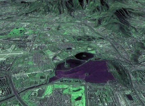
In the last decade, various Digital Earth systems have been developed, such as Google Earth, VirtualEarth, and Skyline (Google Earth Citation2005, VirtualEarth Citation2005, and Skyline Citation2006). Google Earth, developed by Google Inc., firmly combined remote sensing information with Digital Earth. Based on China's land satellite data, the China Centre for Resources Satellite Data and Application overcame the problem of massive data storage and visualization, and developed the CBERS three-dimensional Earth display system, which played an important role in the monitoring of national major projects and major natural disasters ( and ).
Figure 2. CBERS Earth operation interface.
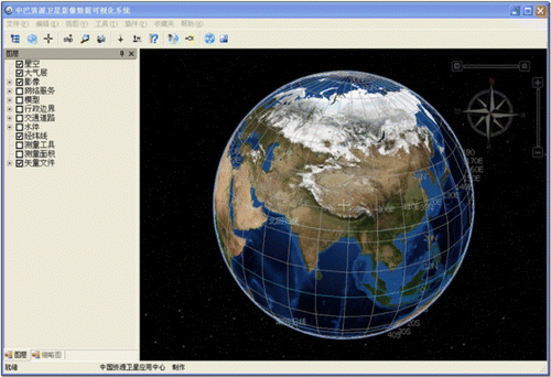
Figure 3. 3-D image of the western suburbs of Beijing.
4. Key technologies
4.1. Space–Earth integrated observation technology
Space–Earth integrated observation is at the center of land satellite observation networks. Compared with single-satellite observation systems, it requires more integrated management of different satellites by ground processing systems. Specifically, comprehensive observation tasks must be allocated to different satellites according to the characteristics of satellite payloads and user requirements for spatio-temporal resolution. In this process, an observation program is developed to properly command and coordinate the operation of different satellite payloads and to make the best use of satellite resources.
Space–Earth integrated observation involves many aspects, such as multisatellite network observations, integrated task management, and spatial information extraction and evaluation. Its core technologies include task description and decomposition in complex areas, the collaborative modeling of multiple satellites and payloads, task planning for the joint missions of multisatellite and multiground systems, dynamic collaboration in emergencies, and Space–Earth integrated data processing.
4.2. Technology for integrating and sharing remote sensing data
Large-scale mass information storage is one basic requisite for the development of Digital Earth. A distributed data management system will facilitate the search and query of multisource data, and a new generation of network infrastructure will enable the quick transfer of mass data. However, technology for integrating and sharing data is of crucial importance to retrieve useful information from massive amounts of data. A meta-database and normalization of interface standards will add to the extensibility and interoperability of data management systems and help to quickly identify and display data attributes, such as name and position. In this way, rapid information extraction from massive datasets can be achieved. A grid system is a distributed system connected by high-speed Internet, high-performance computers, large databases, sensors, and remote devices. A Digital Earth grid system will provide a seamless collaborative computing environment for the integration of spatial information and will support the spatial analysis of huge quantities of data.
4.3. Virtual reality technology
Virtual reality technology will be one of the key technologies of Digital Earth. It is an advanced computer user interface that provides users with different forms of real-time interaction, such as vision, hearing, and touch, to facilitate user operation and improve the efficiency of the whole system.
In a Digital Earth system, virtual reality could create a humanized, multidimensional information space. Combined with Geographic Information System (GIS) technology, it can promote the interaction between users and information systems, allowing a better understanding and utilization of geographic information. By introducing remote sensing images and other spatial data, various virtual Earths with different resolutions can be generated in virtual environments. Users can switch at will among the different virtual Earths with voice, gestures, data gloves, and other interaction media.
The development of virtual reality technology will greatly advance the development of Digital Earth, especially in taking advantage of the geographical models and analysis tools of virtual geographic environments. With virtual reality, the spatial information from Digital Earth could be further interpreted, which may promote Digital Earth applications to a higher level.
4.4. Quantitative remote sensing technology
Remote sensing technology not only provides basic spatial data for Digital Earth but also has great prospects for applications in diverse industries. Aimed at the application requirements of industries, the development of quantitative remote sensing will promote the use of remote sensing technology by people from all walks of life. It is also an important way to accelerate the development and application of Digital Earth.
Currently, quantitative remote sensing is at the frontier of remote sensing technology, which includes image registration, atmospheric correction, radiometric calibration, quantitative parameter retrieval, optimization of quantitative thematic products, and information extraction with new-type payloads. Chinese scholars have conducted extensive research in these fields, but quantitative retrieval algorithms suitable for China's satellite payloads are relatively rare and require further study.
4.5. Image fusion technology of multipayload, multiscale, and multitemporal remote sensing data
Image fusion is mainly focused on the processing and integration of multisource data. It is a technology to achieve an objective, essential understanding of a certain object by complementing different information sources. With the diverse development of satellite resources, image fusion technology of multipayload, multiscale, and multitemporal data has become an effective way to extract land surface information and enhance the potential applications of remote sensing data.
Image fusion of remote sensing data involves several steps, such as geometric calibration, image registration, and image fusion. The main idea is to apply high-precision geometric calibration and registration to remote sensing data from different payloads with different spatial and temporal resolutions and to ultimately extract more accurate information with appropriate algorithms. Image fusion technology has been widely used in the fields of target identification, change detection, and land cover classification. At the same time, it also provides high-quality remote sensing images for three-dimensional display in Digital Earth.
5. Summary and prospects
Based on the development of China's land observation satellites, this article introduces the function of China's satellites within the framework of Digital Earth and discusses the relative key technologies. China's land satellites can provide basic data support and application services for Digital Earth with their diverse payloads. With further research on key technologies, such as Space–Earth integrated observation, information integration and sharing, and virtual reality, remote sensing information is bound to play a more substantial role in the construction of Digital Earth.
It has been more than 10 years since the concept of Digital Earth was first proposed in 1998. The development of China's land satellites started in 1999, marked by the launch of the CBERS-01 satellite. Up to now, China has launched two series of land observation satellites, the resource and environment series, and will develop a new Earth observation system to cope with future demands. As an important component of global observation systems, China's land satellites will help usher in the era of Digital Earth with steady development and powerful support for its construction.
Notes on contributor
Professor Xu Wen is General Director of the China Centre for Resources Satellite Data and Application (CRESDA). He is also the Director of the Board of the China Association of Remote Sensing Application (CARSA), Vice-President of the Environmental Association Branch of CARSA, and a part-time professor at Wuhan University. He has abundant experience in aerospace systems engineering management, especially in remote sensing satellite ground systems. He has been both chief-engineer and chief-commander in charge of the ZY-1 series satellites and ZY-3 satellites. He has strong organization ability in setting up remote sensing data processing ground systems for Chinese land observation satellites to process many kinds of satellite payload data, such as CBERS-03/CBERS-0304, HJ-1A/HJ-1B/HJ-1C, CBERS-02C, and ZY-3.
References
- Chen , Y. and Chen , Q. , 2001 . China–Brazil Earth Resources Satellite . Spacecraft Engineering , 11 2, 3 , 129 – 135 . in Chinese
- Craglia , M. 2008 . Next-generation Digital Earth . International Journal of Spatial Data Infrastructures Research , 3 ( 1 ) : 146 – 167 .
- Goodchild , M.F. 1999 . Implementing Digital Earth: a research agenda . In Proceedings of the International Symposium on Digital Earth-Towards Digital Earth, 29 November , 1999 . Beijing : Science Press .
- GoogleEarth , 2005 [online]. Available from: http:earth.google.com/ [Accessed 4 May 2011] .
- Gore , A., 1998 . The Digital Earth: understanding our planet in the 21st Century . Presented at the Californian Science Center , Los Angeles California 31 January 1998 .
- Guo , H.D. , Liu , Z. and Zhu , L.W. 2010 . Digital Earth: decadal experiences and some thoughts . International Journal of Digital Earth , 3 ( 1 ) : 31 – 46 .
- Li , D. , Gong , J. , and Shao , Z. 2010 . From Digital Earth to Smart Earth . Geometrics and Information Science of Wuhan University , 35 2 , 127 – 132 . in Chinese
- Skyline , 2006 [online]. Available from: http://www.skylinesoft.com [Accessed 4 May 2011] .
- VirtualEarth , 2005 [online]. Available from: http://www.microsoft.com/virtual-earth/ [Accessed 4 May 2011] .
- Wang , Q. , Wu , C. and Li , Q. 2010 . Environment Satellite 1 and its application in environmental monitoring . Journal of Remote Sensing , 14 ( 1 ) : 104 – 120 .
- Xu , G. , 2000 . “Digital Earth” construction to promote the sustainable development of China and the world . Aerospace China , 26 1 , 6 – 9 . in Chinese
- Yue , T. et al. , 2008 . Analysis of China's future satellite remote sensor development . Spacecraft Engineering , 17 4 , 77 – 82 . in Chinese