Abstract
The Environment and Disaster Reduction Satellite Constellation is a small satellite constellation developed by China for disaster monitoring. The two primary optical satellites, HJ-A and HJ-B, were successfully launched in September 2008. The satellites carry a charge-coupled device, hyperspectral imager, and infrared scanner, and have the capability for wide coverage and rapid revisits in disaster reduction applications. Also scheduled to be launched is the HJ-C, which will carry synthetic aperture radar and have the ability to provide all-weather observations at any time. A follow-up ‘4 + 4’ satellite constellation including four optical satellites and four radar satellites is in the works, to achieve the capability of quantitative, all-weather, all-time disaster forecasting, monitoring and assessment. The corresponding disaster reduction application system has a series of functions including remote sensing data processing, disaster monitoring and assessment, decision support, and user service and information distribution, which serves the whole process of disaster management. Since its construction has been carried out, the system has successfully dealt with several huge domestic and international natural disasters, and effectively improved scientific decision support. The follow-up system's construction will integrate, update, and extend the original system to fulfill large-scale, quantitative, all-weather disaster operation application needs.
1. Introduction
Within the context of global climate change, the risk of natural disasters is increasing all over the world. Large natural disasters occur often, seriously affecting economic development and social progress. Facing serious losses caused by various disasters, disaster management has become a major focus of governments and citizens of all countries. With the development of space technology, its applications in disaster prevention and relief have drawn more and more attention, and also show huge potential. Especially during recent years, many countries have launched or will launch various Earth observation satellites as effective means for disaster prevention and mitigation. China has been one of the most affected countries in the world. During the two decades from 1990 to 2009, the death toll for natural disasters in China was about one-tenth of that of the world, the affected population was more than half of that of the world, and the direct economic loss amounted to about one-fifth of that of the world.
With the increasing effect of natural disasters, the necessity and urgency of remote sensing applications in natural disaster prevention and risk reduction have been increasingly prominent. The Chinese National Committee of Disaster Reduction, along with relevant departments, conducted joint feasibility studies and proposed the ‘Environment and Disaster Monitoring and Forecasting Small Satellite Constellation’ construction plan in 1998. Finally, the project was approved by the State Council in 2002. Two satellites were launched in 2008, marking a good beginning to the construction and development of the constellation.
2. Construction and development of the constellation
2.1. Composition and operation of the constellation
The Environment and Disaster Monitoring and Forecasting Small Satellite Constellation (Environment and Disaster Reduction Constellation) is China's special satellite constellation for disaster monitoring and forecasting, is one of the four series of Earth observation satellites for civil remote sensing proposed in the White Paper on Chinese Space Flight, and is also the first Chinese civil Earth observation system with multiple satellites and sensors. The Environment and Disaster Reduction Constellation is designed for wide coverage, middle/high spatial resolution, and rapid revisit. This can provide a timely, high-quality, stable data resource for disaster observation and forecasting, emergency response, disaster assessment, and decision support. It can also support scientific progress in disaster risk research.
The Environment and Disaster Reduction Constellation is being constructed in two steps. The first phase includes launching two optical satellites (HJ-A and HJ-B) and a radar satellite (HJ-C), forming a ‘2 + 1'constellation. HJ-A and HJ-B, which have already been launched, are the new generation of small, civilian, optical Earth observation satellites in China. They have functions for orbit lift and orbital inclination adjustment, which are suitable for constellation operation. The satellite constellation formed by HJ-A and HJ-B is China's first optical remote sensing constellation, and with their in-orbit network construction, the two satellites can complete remote sensing tasks by the means of relay observation. The satellites’ orbits are located in a 650 km sun-synchronous orbit and were simultaneously launched by one rocket. The two satellites left the rocket one by one, and because of different detachment speeds, the phase difference of each increased. When the phase difference reached 180°, the two satellites were both in the same target orbit altitude, and the satellite constellation was completed. has some important parameters of the orbit of HJ-A and HJ-B.
Table 1. Important parameters of the orbit of HJ-A and HJ-B.
On 6 September 2008, HJ-A and HJ-B were launched successfully at the Taiyuan Satellite Emission Center. An in-orbit test and application test both showed that the parameters of the satellites had met the design requirements and they were operational. On 30 March 2009, their data were officially available to users for application (Fang et al. Citation2009, Shen and Bai Citation2009). As of 1 July 2011, the satellites have stably operated for 1026 days, more than 15,100 cycles, more than 6800 tracks, and obtained more than 500,000 images constituting nearly 70 TB of data covering most of the world's land area. The constellation provides a stable data resource for disaster emergency monitoring.
2.2. Payloads
HJ-A, HJ-B, and HJ-C carry four remote sensing payloads: a charge-coupled device (CCD) camera (HJ-A and HJ-B), hyperspectral imager (HSI) (HJ-A), infrared scanner (IRS) (HJ-B), and S-band synthetic aperture radar (S-SAR) (HJ-C). lists some of the sensors’ more important parameters.
Table 2. Technical specifications of the sensors on HJ-A, HJ-B, and HJ-C.
HJ-A and HJ-B each carry a CCD sensor with 30 m spatial resolution and four wave bands (B, G, R, and NIR). By strict view field matching, the width of a single image reaches 700 km, which is the widest in the world compared with other multispectral sensors with the same spatial resolution. The wide coverage provides a high-temporal resolution, so the revisit time can be shortened to two days with the binary satellite network, and a seamless re-observation of China and surrounding areas in 2 days can also be achieved. The general scheme, using a multispectral CCD with the smallest pixel size and a short focal length, ensures the camera is light and small. The weight of a signal sensor is less than 70 kg. A high revisit time can fulfill requirements for rapid response and large-scale observation of sudden disasters, and it can provide a scientific foundation for rapid disaster assessment, emergency relief, post-disaster relief and reconstruction.
HJ-B carries an infrared camera, which provides four infrared bands: near infrared, short wave infrared, medium wave infrared, and long wave infrared. At a 650-km satellite orbit altitude, the width of the imaging reaches 720 km, while the ground pixel resolution is 150 m/300 m, and the satellite can observe all Chinese territories every 4 days. Breakthroughs in technology, including double-faced mirror scanning and calibration; medium and long wave infrared detectors; an integrated chiller; weak signal high-gain amplification and signal saturated fast recovery; and a light, small, but highly-reliable satellite body was made in the research process. In addition, these key technologies have caught up to the advanced international levels. With wide coverage and high-resolution observations, HJ-B can be applied in disaster monitoring and analysis such as fires, snowstorms, droughts, floods, agriculture yield estimation, and pests. It also plays an important role in forecasting and the assessment of natural disasters, and has some ability to monitor at night. Besides this, it has clear application value for earthquake monitoring, geological analysis, vegetation classification, coastal studies, and urban planning.
HJ-A carries a HSI with 115 spectral bands, an average spectral resolution of 5 nm, 100 m spatial resolution, and a 50 km width, which can observe all of China every 4 days. It uses space modulation interference spectral imaging technology, which is based on lateral shearing Sagnac interferometer. With good stability, small size, a high linearity spectrum, and wide spectrum range, it is the China's first HSI in space applications and the first worldwide space modulated interferometer spectral imager for satellite operation. For wide spectral bands combining images with spectrum and fine spectral detection, the HSI has the ability to identify targets that have obvious spectral characteristics and are similar in shape but not in texture. In addition, its fine detection of surface features has important practical value in natural disaster monitoring.
The yet-to-be-launched HJ-C carries S-SAR, which provides 5 m and 20 m spatial resolution and corresponding 40 km and 100 km width. It can observe China every four days. HJ-C uses two imaging modes – strip map mode and scanning mode – and not only meets the requirements of high-resolution observations, but also observes across a large width. It uses parabolic antennas and high-power microwave concentrated transmitting radar systems, reflecting the design characteristics of light, spaceborne SAR systems used by the advanced, light, agile SAR satellites developed outside of China. S-SAR, with its ability to provide penetrating observations, can be used for disaster monitoring and layered vegetation observation in bad weather conditions. So in the future, the Environment and Disaster Reduction Constellation will have all-time and all-weather observation capability.
2.3. Constellation development program
The Environment and Disaster Reduction ‘2 + 1’ Constellation has preliminarily had capabilities of wide range, dynamic monitoring and assessment of natural disasters. However, facing frequent and various Chinese disasters, the ‘2 + 1’ constellation cannot yet guarantee real-time, all-weather monitoring, and the spatial resolution of the satellite cameras cannot meet the requirements of seismic geological disaster monitoring and accuracy assessment.
So based on the ‘2 + 1’ constellation, the second-phase Environment and Disaster Reduction Constellation will form China's first generation ‘4 + 4’ in-orbit constellation, consisting of four optical satellites and four radar satellites. The designed working life of a single satellite will reach 5 years, gradually. With a series of follow-up satellites launches, an in-orbit constellation with high temporal resolution, high spatial resolution, high spectral resolution, wide coverage, and integrated use of visible light, infrared, hyperspectral, radar, and other observation methods will establish global, timely (less than 12 hours) observation capabilities. This will guarantee disaster reduction demands for satellite data are met, enhance comprehensive national disaster reduction capacity, and provide large-scale, all-weather, all-time, dynamic, real-time disaster monitoring to aid in sustainable and stable development of the national economy and society.
3. Construction, operation and development of the disaster reduction application system
3.1. Composition and function
When the satellites were being developed and launched, the satellite disaster reduction application system (DRAS) was being constructed simultaneously. DRAS is an important part of the Environment and Disaster Reduction Constellation's ground application system. The ground application system consists of the operation management system, ground system, DRAS, and environmental application system. The Satellite Telemetry Track and Control Center receives the satellite downlink engineering telemetry data and auxiliary data, transmits it to the operation management system, and uploads encoded data from the operation management system to in-orbit satellites. The operation and management system provides a planning environment for satellite observation, transforms the work plan into encoded data according to received telemetry data, then sends the code to the Satellite Telemetry Track and Control Center and distributes it to each system. The ground system receives image data signals from satellites, generates geometric correction image products, and delivers them to the DRAS.
The main function of DRAS is to be a business application of Environment and Disaster Reduction Constellation data in the field of disaster reduction, and to provide spatial technical support for disaster reduction and relief. DRAS is divided into a disaster reduction application operation management subsystem (DRAOMS), data and database management subsystem, remote sensing data application processing subsystem (RSDAPS), disaster monitoring and early warning subsystem (DMEWS), disaster emergency response subsystem (DERS), disaster assessment subsystem (DAS), decision-making support subsystem (DSS), user service and information release subsystem, and a computer business support platform – a total of eight subsystems and one support platform (Fan et al. Citation2008). illustrates the structure and composition of the Environment and Disaster Reduction Constellation's DRAS at the ‘2 + 1’ phase.
Figure 1. The structure and composition of DRAS at the ‘2 + 1’ phase.
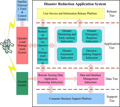
The computer business support platform is the basic support and operation platform of DRAS, and it can provide the basic hardware and software environment for normal, stable, safe, reliable operation, especially for the professional application software environment.
The DRAOMS can help develop and manage production planning, the control of business processes and data flows among subsystems, network monitoring and management, and business connections between the DRAS and operation management system. It also performs task command, planning and scheduling, and system monitoring and management when DRAS is running.
The data and database management subsystem can manage disaster reduction satellite data and disaster reduction application-related information products through online archiving, permanent archive management, and query and retrieval services to ensure data security and integrity.
The RSDAPS can produce disaster reduction satellite data products and other remote sensing data processing. It can test the authenticity of remote sensing data and other subsystems’ disaster reduction application products, as well as provide optimal parameters and processing schemes.
The DMEWS can dynamically monitor and analyze disastrous factors, disaster formative environments, hazard-bearing bodies, and other relevant environmental information or characteristics during natural disasters for early detection. Combined with disaster formation mechanisms and the law of regional differentiation, it can carry out pre-disaster risk assessment and early warning, and forecast the occurrence and development trends of the disaster.
Utilizing disaster reduction satellite data and other data, the DERS can comprehensively and rapidly identify and extract various types of disasters and their change information; dynamically derive and simulate the disaster process; rapidly assess the loss condition of the population, lifeline engineering, housing and others; analyze the disaster relief path and monitor placement for transfer; and provide the basis for disaster emergency relief decision-making.
Based on the precise extraction of a disaster's scope and destructiveness utilizing small satellite constellations and other relevant data, the DAS can comprehensively assess disaster loss, especially the affected population, damaged crops, damaged infrastructure and other indicators; disaster relief, recovery and reconstruction needs; and the effectiveness of disaster rescue operations.
Based on disaster relief experts’ experiences, decision analysis models, and combinations of the information products of other subsystems, the DSS can provide the implementation plans of proposals for risk decision-making, disaster emergency response initiatives, disaster emergency relief requirements, optimal disaster relief resource scheduling, and disaster relief and reconstruction.
The user service and information release subsystem can publish disaster reduction application products. It can browse, search, analyze, and download services of disaster reduction application information products for external network users, while providing an integrated business system portal for internal users.
3.2. Operation flow
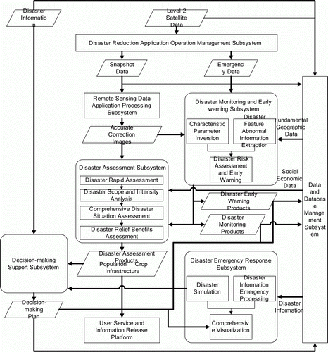
Disaster reduction application system acquires disaster reduction satellites’ standard data products from ground system, then the DRAOMS formulates production and processing tasks according to the features of standard data products, and then submits the tasks to other subsystems for implementation. The RSDAPS immediately processes standard data according to the task assigned by DRAOMS and outputs various image correction products. In the routine mode, the DMEWS uses the products produced by RSDAPS to periodically generate NDVI, WI, and some other parameter inversion products, and produces disaster risk products combined with basic geographic data, meteorological and hydrological data, socioeconomic data and so on. When a high-impact natural disaster occurs, based on features of disaster targets, DMEWS extracts abnormal disaster information, generates disaster monitoring products, and then submits the products to the DASs. At the same time, the DERS simulates disaster development, and obtains the information of affected areas and development trends. DAS comprehensively utilizes the products of remote sensing disaster monitoring, disaster simulation results, disaster information, fundamental geographic data, socioeconomic data and so on, to perform rapid disaster assessment, analysis of the disaster area and intensity, comprehensive disaster assessment, and some other processes. Moreover, DES also continually assesses the relief efficiency based on the disaster relief situation and generates disaster assessment products about population, crops, and infrastructure. The DSS uses the products generated by all operation application subsystems as input data, assumes disaster management decision support analysis, and generates various decision schemes. Finally, disaster information, various data products output by the operation application subsystems, application products, and decision-making schemes are stored and managed by the data and database management subsystem. All the products are uniformly packaged and released to the disaster site headquarters, the National Disaster Reduction Committee members, regional and provincial sub-centers and the public by the user service and information release subsystem. Some products are visually displayed in two-dimensional and three-dimensional styles by DERS, and are used for disaster consultation, disaster relief, disaster recovery, and reconstruction. illustrates the operation flow of the DRAS.
Figure 2. Operation flowchart of DRAS.
3.3. Application effect
Since DRAS was constructed, it has already dealt with many disasters successfully, such as the snow disaster in northern China, sea ice in the Bohai sea, snowmelt floods in Xinjiang, southwestern drought, Yushu earthquake, fire disasters in Northeast China, and floods in South China, and has played an efficient role for decision-making. In addition, it provided multiple early warning, monitoring, and evaluation products for other major events, including fires in Australia, fires at the China–Myanmar border, drought in Africa, the Haiti earthquake, the US oil spill, and Iceland volcano. The space-based observation system of the environment and disaster reduction constellation, combined with the ground application system, constitutes a sky-ground integrated disaster monitoring and evaluation system that greatly improves China's ability for scientific decision-making in natural disasters and international service in regional disaster management.
Disaster reduction application system of the environment and disaster reduction satellites are also effectively applied in crop yield statistics estimation, forest biomass inversion of the Loess Plateau, grass biomass inversion of Hulunbeier grassland, Karakoram mountain glacier monitoring, and urban surface temperature measurement of Beijing and other areas, which has played an important role.
3.4. The follow-up development plan
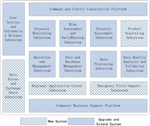
Aiming at the new satellites launched in the ‘4 + 4’ phase, DRAS is planning for corresponding improvement and expansion. DRAS at the ‘4 + 4’ phase consists of 12 subsystems and 2 operation support platforms. They are primarily upgrades and expansions of the original eight subsystems and one platform of the ‘2 + 1’ phase. These include four new subsystems (the data access and exchange sharing subsystem, product generation subsystem, regional application center subsystem, and emergency scene support subsystem); revisions and updates to related data norms, operational rules, and field investigation specifications; and improvements to the indicator system of ‘sky-ground-scene’ integration in disaster remote sensing. On that basis, the new system will improve national satellite-based products and service systems with clear operation processes and corresponding standards; provide dynamic monitoring of large-scale disasters, detailed disaster investigation, early-warning of risks, and all-weather, quantitative monitoring; and satisfy the disaster reduction operation needs of dynamic monitoring and emergency response. illustrates the structure and composition of DRAS at the ‘4 +4’ phase.
Figure 3. Structure and composition of DRAS at the ‘4 +4’ phase.
4. Conclusion and preview
After the launch of the A and B satellites of the Environment and Disaster Monitoring and Forecasting Small Satellite Constellation, they have become an important part of the national disaster spatial information infrastructure, and the satellite data have been integrated into national disaster remote sensing operation systems, becoming a stable and indispensable data source for disaster monitoring and assessment. Satellite users combine remote sensing monitoring and ground routine monitoring through DRAS, providing an important safeguard for the ‘sky-ground-scene’ integrated disaster monitoring network. The construction of the follow-up constellation system will ensure the durability of the necessary space data used in China's disaster management and the stability of remote sensing disaster reduction monitoring platforms. It will further meet the urgent needs for timely, consist and accurate remote sensing monitoring in disaster management. It will provide fast, accurate decision support information for national, comprehensive disaster reduction operations and improve national scientific decision-making. The decision-making support information provided by future follow-up satellites and their DRAS will highly improve China's command and control abilities in disaster relief and reduction. It will form a national disaster operation system with horizontal integration and vertical communication, which will minimize the losses caused by disasters.
Notes on contributors
Yida Fan is currently the Associate Director of the National Disaster Reduction Center of China, Ministry of Civil Affairs, and the Secretary-general of the Expert Committee of the National Disaster Reduction Committee. He received a B.S. degree from Nanjing University of Science and Technology in 1990, and M.S. and Ph.D. degrees from Beijing Normal University in 2000 and 2003. He has taken charge of more than 30 projects from the National Science and Technology Support Program, National 863 Program and international cooperation projects. He has published more than 40 papers and obtained Ministerial-Level Science and Technology Awards in China four times. His research interests are in natural disasters and risk management, disaster remote sensing, and space technology disaster reduction.
Qi Wen was born in January 1983. He received his Ph.D. degree in Signal and Information Processing from the Institute of Remote Sensing Application, Chinese Academy of Sciences and a bachelor degree in Mechanical and Electrical Engineering from the Beijing Institute of Technology. He is now a research associate in the National Disaster Reduction Center of China, and his research interest is space technology disaster reduction and high-resolution remote sensing disaster reduction applications.
Shirong Chen was born in November 1977. He received his Ph.D. degree in Cartography and Geographic Information Systems from the Institute of Remote Sensing Application, Chinese Academy of Sciences, and a bachelor degree from East China Normal University. He is now an associate researcher in the National Disaster Reduction Center of China. His research interest is disaster remote sensing applications.
References
- Fan , Y. , Wang , X. and Yang , S. 2008 . The introduction of disaster reduction application system of environment and disaster reduction satellites . Disaster Reduction in China , 9 : 9 – 11 .
- Fang , Z. , Fan , Y. and Wang , X. 2009 . An evaluation of on-orbit test of HJ-1A/1B Satellites . Spacecraft Engineering , 18 ( 6 ) : 23 – 26 .
- Shen , Z. and Bai , Z. 2009 . HJ-1A/1B satellites in-orbit performance evaluation . Spacecraft Engineering , 18 ( 6 ) : 17 – 22 .