Abstract
Digital lightning is an important thematic branch of the digital earth. Lightning data are complex, momentary, discrete, dynamic and spatio-temporal in nature. Hence, making great progress in their management, analysis and service is challenging. Many studies have been directed towards this field all over the world. Some different relevant systems are currently available. However, most of them focus on a single or a few aspects of lightning applications, rather than taking an overall account of lightning detection, management, analysis and service from the strategic perspective of the digital earth. Lightning disaster also demands a better developed spatial information technology in this field than at present. The idea of the digital earth offers a reasonable scheme to address these issues. Based on reviews of the concept, development and progress of the digital earth, an integrated technical framework of a digital lightning prototype system (DLPS) is proposed, including its data, functions and implementation of subsystems, which aims at the facilitation, management, accessing, visualisation, application, release and sharing of lightning data. Some key technologies are also carefully discussed to facilitate the construction of the DLPS. This framework could provide a helpful guide to future lightning research and hazard mitigation, as well as enrich connotation on the digital earth. So far, there are still many difficulties in multi-level grid construction that need to be solved.
1. Introduction
The digital earth endows human beings with a new angle of viewing the world, which can be deemed as a great leap for mankind in understanding the Earth. The appearance and construction of the digital earth is a profound revolution not only in science and technology but also in the quality of life (Chen and van Genderen Citation2008, Goodchild Citation2008).
The concept of the digital earth has been first proposed by Al Gore (Citation1998). Its original aim is to integrate a tremendous amount of resources from the real world into a virtual earth. In theory, the digital earth is a high-level integration of earth science, space science and information science (Li Citation2004, Guo et al. Citation2009). Technically, it is an effective combination and application of several modern technologies, such as remote sensing (RS), geographic information science (GIS), global positioning system (GPS), database, wireless and wired networks, as well as virtual simulation. In other words, the digital earth can be regarded as an informational earth, containing the digitalisation, visualisation, networking and intellectualisation of physical earth data. In 1999, the first International Symposium on Digital Earth (ISDE) was held in Beijing. More than 500 delegates from 27 countries attended this symposium, which was a milestone in the globalisation advancement of the digital earth. The sixth ISDE held in Beijing in September 2009 was another milestone in the history of the digital earth. Guo et al. have described the 10 years of development of the digital earth (Guo et al. Citation2010). In August 2011, the seventh ISDE was convened at Perth in Australia. With the continuously increasing influences and applications of the digital earth, there have been great progresses in wide aspects of human life during this decade. Such progresses include those involving the sustainable development of societies and economies, environment and natural resources, precision agriculture, human life and intelligent traffic. The digital earth is not only a magnificent potential instrument for fusing different kinds of geospatial data but also a stepping stone towards building a comprehensive information home of mankind.
Currently, some digital earth branches have appeared, such as digital ocean (Zhang et al. Citation2011), digital city, digital power, digital river basin and so on. Digital lightning is a new research field of the digital earth. It is born with building an ‘information home’ and providing us a better understanding of lightning. The core idea of digital lightning is to apply the theories, methods and techniques used in digital earth to address today's large-scale lightning problems. The purpose is to study the spatio-temporal patterns of lightning and reduce the damage it causes to the minimum.
Lightning is one of the most powerful and spectacular natural phenomena that mankind has ever encountered. It is not only breathtakingly beautiful, but also treacherous and menacing at the same time. Every year, about three billion lightning flashes occur throughout the world. There are numerous documents showing that lightning is a threat to humans. In the UK, about three people are annually killed by lightning, and the number of people injured by lightning is about 50 (Elsom Citation2000). In the USA, there were about 2566 deaths and 6720 injuries caused by lightning from 1959 to 1985 (Duclos and Sanderson Citation1990). In South Africa, about 1.5 per million deaths per year in urban regions are caused by lightning. The rate is about 9 per million in rural areas (Meel Citation2007).
These tragic incidences have rendered lightning as a hot research topic in meteorology, disaster and information science. To reduce the danger and damage caused by lightning and make communities safer, worldwide research efforts have been directed toward lightning activity, particularly its detection and physical mechanism (Ramirez-Vazquez et al. Citation2004, Rakov et al. Citation2005). Many different relevant systems are currently available, such as the National Lightning Detection Network of the USA (Cummins et al. Citation1998) and the Boltek website (http://www.boltek.com/) that offers lightning application software. All these systems have achieved considerable and valuable progress. However, most of them only focus on a single or a few aspects of lightning applications, such as detection efficiency, data service or visualisation, rather than taking an overall account from the strategic view of the digital earth. In recent years, spatial information technology, which is widely used in such fields as environmental and disaster management, has rapidly developed. Some researchers have tried to apply the GIS technology to study the relationship between lightning activity and climatology (Stallins and Bentley Citation2006). Many useful products in lightning data analysis have been made, although they cannot yet meet the increasing demand for the information development of lightning. Based on the idea of the digital earth, the digital lightning prototype system (DLPS) is put forward. The DLPS tries to combine spatial database, GIS, spatial information grid, three-dimensional (3D) visualisation and computer networking with other spatial information technologies. The purpose is to provide a new scientific and reasonable way to deal with the acquisition, intelligent storage, integrated management, copious spatial and statistical analyses of lightning spatial data, as well as address various problems in the service and application of lightning data.
Based on the analyses of the characteristics and classification of lightning data, the present article discusses in detail the concept, aims and architecture of digital lightning. According to the concept of the digital earth, a corresponding DLPS designed and developed by the Huazhong University of Science and Technology (HUST), named the DLPS/HUST, is proposed. Some key technologies used to facilitate the construction of the prototype system are also described.
2. Lightning data
2.1. Characteristics of lightning data
Lightning events dynamically occur. The characteristics of lightning data are as follows.
2.1.1. Complex data types and large amounts of data
Lightning data contain the fundamental geographical data of the area covered by lightning monitoring network, the aerial remotely sensed image, the lightning thematic data, as well as various graphical data and reports generated from spatio-temporal analyses and operations. All these data may come from different sources. The fundamental geographical data are obtained from the National Geomatics Center of China (NGCC) as well as national surveying and mapping agencies. The lightning thematic data are acquired from field detecting stations as well as several professional processing and location algorithms about lightning. They are either the raster data stored in pixels, or the vector data represented by geometric figures and the attribute data that describe the corresponding spatial features. Both the coordinate system and the scale size of these data are not strictly uniform, resulting in the complexity of lightning data. The lightning thematic data are also updated in real time. Hence, the total amount of lightning data is enormous.
2.1.2. Highly dynamic and time sensitive
Lightning is not stationary; it changes dynamically over time. To ensure the accurate and effective detection of lightning, the status information of detecting sub-stations, original lightning records and lightning location data need to be fed back into the lightning spatial database and updated real time. Indeed, the dynamic effectiveness and time sensitivity of lightning data is very obvious.
2.2. Classification of lightning data
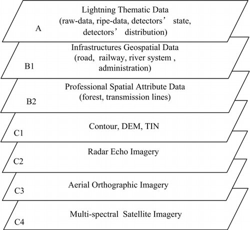
Lightning data with different formats and sources are mainly generalised into three key types in the proposed system: (1) lightning thematic data; (2) general geographical data that contain infrastructural data such as railways, roads and bridges, as well as administration distributions; and (3) other data relevant to lightning, such as the digital elevation model (DEM) and aerial orthographic images. In the following subsections, the data structure and contents of every type are illustrated in more detail.
2.2.1. Lightning thematic data
According to their contents, lightning thematic data can be classified into raw data, ripe data, detection status and spatial distribution of detecting stations. Raw data are a series of records detected by lightning detecting stations and obtained via network transmission. These data are un-located and temporarily stored as tables with lots of property fields for the data receiver of lightning (see ). With the aid of the positioning calculation of the lightning location system, the ripe data, a series of points with detailed positional information (such as longitude and latitude), are obtained. Ripe data are indispensable to lightning analysis and such applications as lightning early warning and super-short forecast. Ripe data are also stored as tables but have some different fields from those of raw data (see ).
Table 1. Schematic attribute tables for lightning thematic data.
To obtain lightning information, detector information should be contained in the database. There are two types of information about detectors, namely, non-spatial tabular data with several properties about the detector status information and the feature layer about the spatial distribution of the detector. One of the most important properties of detector status is the ‘result of self test’, which has two values, 0 and 1. ‘1’ represents a normal state and ‘0’ is abnormal (see ). The feature layer of the spatial distribution of the detector (see ) is added to the map when lightning activities are monitored. The layer consists of several detector features and has an attribute table with many property fields. The ‘latest state’ field needs updating in accordance with the detector status table. If the field value is ‘1’, the detector feature is highlighted in green. If the field value is ‘0’, the highlighting is red.
2.2.2. General geographical data
General geographical data mainly contain fundamental geographical and thematic information relevant to the serving objects. The former involves basic geographical features, including traffic lines (e.g. road, railroad, high-speed road), key river systems, administrations that contain administrative boundaries, local government and residential areas, as well as other public infrastructures. The latter is concentrated on the construction of different professional spatial attribute tables (e.g. forest and transmission lines) for thematic meteorological businesses.
2.2.3. Other data related to lightning
To further broaden the application of lightning spatial data, other vector and raster datasets can be added to the study. Lightning occurrence is usually influenced by the terrain. Hence, elevation data should be included, and these data can either be digitalised contour or DEM and triangulation irregular network format data, because they can be constructed from each other. Otherwise, additional data such as aerial orthographic, satellite and radar echo images should also be included in the proposed system. Multi-source geospatial data used in the DLPS are demonstrated in .
3. DLPS framework
3.1. Concept and aims of the DLPS
Digital lightning is an important branch of the digital earth. Based on the digital earth theory, digital lightning is an integrated application of several information technologies. It is also an information system that aims to fulfil the digitalisation of lightning detection, acquisition, storage, management, analysis, application and service based on the characteristics of lightning. This kind of system will be very valuable to different lightning users and meet the demands of society for lightning information. The overall objective of the DLPS is to build such an integrated system that can address issues in lightning information detection, management, comprehensive analysis and sharing service. The specific aims of the proposed system are as follows.
To achieve a lightning spatial database management system (DBMS) covering multi-source and heterogeneous data. The database system should be able to solve the problem of centralised data storage and management, ensuring data consistency, completeness, sharing and safety, as well as realising scientific and standardised data management. Consequently, the management level and efficiency of lightning is improved, and more scientific as well as reliable data services for other lightning thematic business systems are provided.
To construct a visual lightning analysis and application platform oriented to many thematic operational systems. The DLPS should provide two-dimensional (2D) and 3D displaying platforms for lightning essential and thematic data. Based on this, visual management, comprehensive analysis and multiple thematic applications are realised.
To implement a lightning spatial information grid (LSIG) system. Many different kinds of grids, such as multi-grain, regular and irregular, as well as many lightning-related subjects, should be constructed. For meteorology engineering and other important lightning protection areas, a window analysis operation could be performed. A new service pattern on lightning information products could also be provided.
To fulfil a release and sharing platform for lightning information oriented to communities and the general public. The DLPS could provide a lightning information sharing platform based on a network, as well as release the real-time lightning information, lightning forecasting and early warning products on the Internet.
3.2. General design of the DLPS
3.2.1. System architecture and key functions
To achieve the aforementioned goals of the proposed system, the entire architecture of the DLPS is classified into five tiers. These tiers are data acquisition, data storage and management, integrated analysis and display, thematic application and release, as well as sharing (see ).
Tier 1, data acquisition tier.
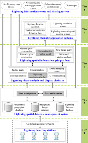
Tier 2, data storage and management tier.
Tier 3, integrated analysis and display tier.
Tier 4, thematic application tier.
Tier 5, release and sharing tier.
3.2.2. Data processing flow of the DLPS
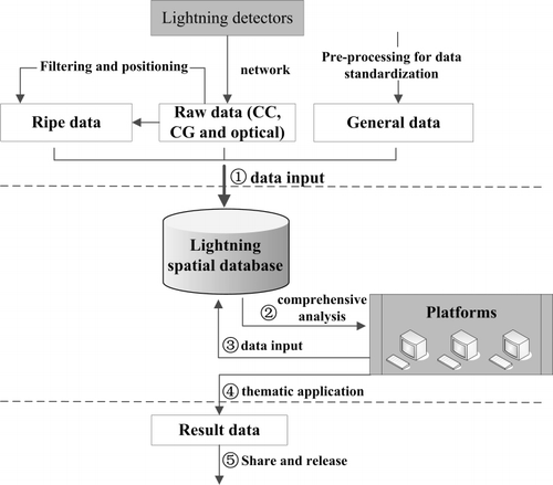
As aforementioned in preceding sections, lightning data can be generalised into general, ripe, raw and result data. The first three types have been defined. Result data are the products of the comprehensive analysis and applications of general data and lightning thematic data based on the DLPS platforms, mainly including thematic maps, data tables, thematic grids and 3D spatial data.
The data processing flow of the four major categories in the DLPS is shown in . First, a variety of relevant lightning data are collected. All types of raw lightning data (CC, CG and optical) can be detected by the station network. After the pre-processing of positioning computation and standardisation, these data are stored in the database. Second, these data are retrieved to realise lightning live display, query, statistical analysis, grid construction and other operations through platforms. Third, these operation results are stored in the database if necessary. Fourth, several relevant lightning analysis agencies use their professional models to achieve thematic applications according to their own special needs. Some professional and useful results are then formed. Fifth and finally, result data are released, fulfilling the sharing service on the network.
4. Implementation of the DLPS
According to the architecture and components of the DLPS aforementioned, a framework of the DLPS has been primarily implemented by the HUST. Visual Basic and C sharp programming languages within the.NET framework are chosen to facilitate the development of DLPS.
4.1. Lightning spatial database (LSDB)
Lightning events dynamically vary with the space and time, producing a large volume of data each day. The three-tier system configuration is regarded as fairly suitable for the database implementation of a large data volume, as well as for supporting the manipulation and analysis of temporary data processing (Al-Sabhan et al. Citation2003). Therefore, a three-tier architecture, with a front-end application tier, middleware tier and data/resource tier, is implemented in the proposed system (see ).
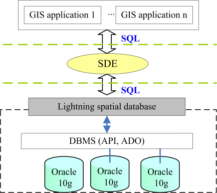
The data/resource tier is the most vital tier in the database and provides data-level support for the entire system. The powerful storage performance of the DBMS is utilised. Based on the structured query language, the front-end GIS applications interact with the database system via the middleware spatial data engine (SDE), application programming interface and ActiveX data objects, which contains remote data objects and data access objects.
4.2. Lightning geographic information system (LGIS)
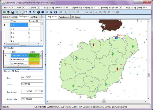
The LGIS in the DLPS is a lightning-oriented geographic information system with basic functions of GIS and some advanced functions on thematic lightning. The LGIS contains both 2D and 3D platforms. In the 2D LGIS, lightning activities and detection status are monitored in real time. Historical lightning data can be queried and replayed in a dynamic way within a particular region by choosing the start and end time. Lightning characteristics such as thunder day, hour and density are important parameters in lightning research and decision-making. These parameters can also be determined on the side of the 2D LGIS. In the 3D LGIS, the 3D scene of basic terrain can be modelled and simulated by overlaying the remotely sensed imagery and the processed DEM data. Based on this, the 3D scene of thematic lightning can be reproduced from the real world in the ESRI® ArcScene® environment (see ).
4.3. Lightning spatial information grid
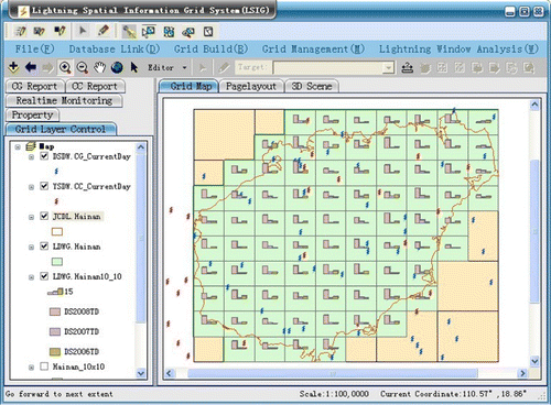
The LSIG in the DLPS is put forward for the first time in the fields of lightning application and service, which integrates GIS, spatial information grid and database techniques. The aim of the LSIG is to provide a better grid-based lightning analysis and service to help users find more spatio-temporal patterns of lightning. The LSIG offers multi-level grids. Before building the basic grid within a particular region, the grid grain should be defined. After lightning characteristic values are collected into the basic grid, the lightning thematic grid can be obtained. Subsequently, numerous spatio-temporal window statistics and analyses can be carried out on the LSIG side (see ).
4.4. Lightning information release and sharing system (LIRS)
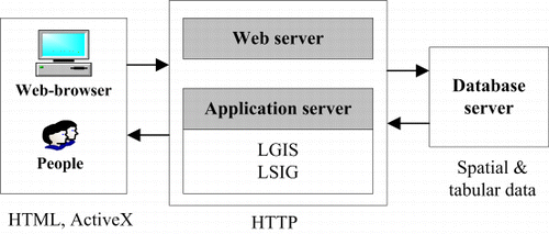
On the side of the LIRS (), the user interface is based on a web-browser and will be developed with ActiveX controls as well as ArcServer secondary developer kits. The control of ActiveX, which is used with hypertext makeup language in this system, is a modular piece that performs tasks as well as communicates with other programs and modules over the Internet/intranet. Based on a hypertext transportation protocol request–response mechanism, people can browse and query up-to-date lightning activities released by the government, and then send their requests to share lightning spatial data via the website. The LIRS can provide a better understanding of lightning and consequently increase our awareness of protective measures against it.
5. Key technologies of the DLPS
5.1. Storage and security technology of massive spatial data
The DLPS contains not only actual lightning data but also other relevant space and ground data. Compared with traditional character-type data, these relevant lightning data have typical features in space, attribute, topology and time. When the data quantity reaches the terabyte level, a great challenge to data storage and security is posed. Hence, the storage and security technology of massive and heterogeneous spatial data is one of the key factors that must be considered in evaluating the practical value of a system.
The aforementioned technologies face many difficulties, such as searching for a better solution to the integrated organisation and storage problems of the multi-source, heterogeneous and massive lightning data. Another difficulty lies in finding a better scheme for overcoming database conflicts and hidden dangers brought about by multi-user concurrent access. Traditional databases cannot easily meet the storage requirements of massive spatial data. The combination of SDE technology and Oracle 10g relational database technology has shown tremendous advantages in spatial data storage. In the DLPS, this combined technology is also considered to achieve an effective organisation of massive spatial data as well as a seamless link between spatial data and attribute data. Regarding data conflict and security issues, these may be addressed by version control mechanism, automatic recovery and backup mechanism for ensuring the database security.
5.2. Customisation technology of thematic lightning GIS
Geographic information science is widely applied in meteorology. However, traditional information management systems are still commonly used in such lightning-related domains as monitoring and location, information management and application, spatio-temporal analysis, as well as nowcasting decision support. These traditional systems cannot meet the growing needs for lightning digitisation and visual management. Therefore, the GIS customisation technology of thematic lightning must be enacted to obtain powerful GIS advantages in data management and spatial analysis. ArcEngine is a flexible, application-neutral programming environment that comprises easy-to-build reusable program blocks and code bases for future extension. The ArcEngine technology may be used to build a customised GIS visualisation application system for lightning. The proposed setup does not require the complete ArcGIS Desktop environment, but only the ArcGIS Engine runtime library (taking about 301 MB of disk space) (Liang et al. Citation2007).
5.3. Multi-level grid construction oriented to lightning
Lightning spatial data cover a large range of areas. These complex data need to be scientifically manipulated to study more lightning patterns in space and time. Multi-level grid construction technology provides a heuristic solution.
Nevertheless, the construction of lightning multi-level grids is challenging. The lightning mesh generation standard needs to be defined, a probable grid-encoding method must be chosen and there must be a suitable representation for these multi-level grid data. Regarding the mesh generation standard definition, if the grain is too large, some key details may be lost. If the grain is too small, data redundancy results. Therefore, appropriate grain selection is essential in building a lightning thematic grid. Different levels of grids and the properties within a grid adopt a uniform encoding method, such as the classic quad-tree coding approach. The ‘level of detail’ technology can be used to represent a multi-level grid of lightning.
6. Conclusion and future work
The present article tries to integrate GIS, databases, RS, visual reality, 3D visualisation, spatial information grid and computer networking to build a DLPS from the perspective of the digital earth. Based on a careful investigation of existing researches on lightning, some basic knowledge and substantial progresses on digital lightning have been discussed. First, from the viewpoint of the digital earth application, digital lightning is a novel concept and application mode. The DLPS is an important step towards digital lightning from a mere concept to a realistic system. Second, from the perspective of data integration of the digital earth, the DLPS encompasses numerous types of data, such as lightning thematic data, general geospatial data, remotely sensed imagery and lightning product results. Third, from the standpoint of system application and service, the DLPS is deemed as an effective and integrated multi-platform tool for data management, complex analysis, 3D visualisation and information sharing of heterogeneous lightning data. Fourth and finally, for user groups, the highly targeted and practical DLPS offers a universal platform for lightning research by relevant agencies and the public, with the aim of elucidating the characteristics of lightning and the protective measures against it.
At the time of paper submission, the DLPS has been primarily implemented according to the proposed architecture and components. However, DLPS construction is a long-term and strategic task. The current article is a tentative study on the framework and development of the system, and hopes to provide guidance to the future lightning research and hazard mitigation. Although some key technologies of digital lightning have been discussed, there are still some technical problems. Techniques such as lightning signal analysis, feature extraction and data optimisation need further study. Therefore, there is a broad space in which to perfect the system in the near future.
Acknowledgements
The authors would like to appreciate the financial support for this study from the National Key Technology R&D Program of China (Grant#2008BAC36B01), the Program for New Century Excellent Talent of Ministry of Education of China (Grant #NCET-07-0340), the Natural Science Foundation for Outstanding Scholarship of Hubei Province in China (Grant#2008CDB364) and the National Natural Science Foundation of China (Grant #41072199 and 40672179). The authors also would like to thank the anonymous reviewers for their helpful comments and useful suggestions.
References
- Al-Sabhan, W., Mulligan, M., and Blackburn, G.A., 2003. A real-time hydrological model for flood prediction using GIS and the WWW. Computers, Environment and Urban Systems, 27, 9–32.
- Chen, S. and van Genderen, J., 2008. Digital Earth in support of global change research. International Journal of Digital Earth, 1 (1), 43–65.
- Cummins, K.L., et al., 1998. A Combined TOA/MDF Technology Upgrade of the U.S. National Lightning Detection Network. Journal of Geophysical Research, 103 (D8), 9035–9044.
- Duclos, P.J. and Sanderson, L.M., 1990. An epidemiological description of lightning-related deaths in the United States. International Journal of Epidemiology, 19, 673–679.
- Elsom, D.M., 2000. Deaths and injuries caused by lightning in the United Kingdom: analysis of two databases. Atmosphere Research, 56, 325–334.
- Goodchild, M.F., 2008. The use cases of digital earth. International Journal of Digital Earth, 1 (1), 31–42.
- Gore, A., 1998. The digital earth: understanding our planet in the 21st century. Available from: http://www.citeulike.org/user/pajoma/article/4925909 [Accessed 16 May 2011].
- Guo, H., Fan, X., and Wang, C., 2009. A digital earth prototype system: DEPS/CAS. International Journal of Digital Earth, 2 (1), 3–15.
- Guo, H., Liu, Z., and Zhu, L., 2010. Digital Earth: decadal experiences and some thoughts. International Journal of Digital Earth, 3 (1), 31–46.
- Li, D., 2004. Opportunities for geomatics. Geomatics and Information Science of Wuhan University, 29( 9), 753–756. (in Chinese)
- Liang, H., Arangarasan, R., and Theiler, L., 2007. Dynamic visualization of high resolution GIS dataset on multi-panel display using ArcGIS engine. Computers and Electronics in Agriculture, 58, 174–188.
- Meel, B.L., 2007. Lightning fatalities in the Transkei sub-region of South Africa. Medicine science and the law, 47 (2), 161–164.
- Rakov, V.A., Uman, M.A., and Rambo, K.J., 2005. A review of ten years of triggered-lightning experiments at Camp Blanding, Florida. Atmospheric Research, 76, 503–517.
- Ramirez-Vazquez, I., et al., 2004. Analysis of the Mexican lightning activity monitored by NASA satellites. Electric Power Systems Research, 72, 187–193.
- Stallins, J.A. and Bentley, M.L., 2006. Urban lightning climatology and GIS: an analytical framework from the case study of Atlanta, Georgia. Applied Geography, 26, 242–259.
- Zhang, X., et al., 2011. China digital ocean prototype system. International Journal of Digital Earth, 4 (3), 211–222.