Abstract
The Chinese Government attaches great importance to applications of satellite remote sensing in environmental monitoring. On 6 September 2008, the first two satellites of the Environment and Disaster Monitoring and Prediction Satellite Constellation (HJ), HJ-1A and HJ-1B, were successfully launched, which started a new era of satellite applications for environmental monitoring in China. An introduction to the satellite, instrument, and ground systems of HJ-1A and HJ-1B is presented in this article, and an analysis of their technical performance and characteristics is also given. Focusing on the operational needs of environmental monitoring in China, the general design, functional construction, and operational mode of the application system of HJ-1A and HJ-1B are detailed, and the operations and applications of the two satellites are also discussed.
1. Background
Environmental monitoring is the foundation of environmental protection and management. For a long time, environmental monitoring in China has used physical and chemical atmospheric parameters obtained at observation sites as primary data sources. Due to the lack of a constant, all-weather observation system focused on the environment, it has been impossible to achieve accurate and timely observations of ecological and environmental changes with broad and continuous coverage. Benefiting from the development of spatial technology, environmental monitoring has employed remote sensing, which provides large-scale, quickly gathered, huge amounts of information, as an important method of observation. Remote sensing is capable of monitoring the Earth's surface from space, providing broad, synchronous, continuous data to break through the limitations of ground-based observations and greatly improve the capability and efficiency of environmental monitoring (Wang et al. Citation2005). As the promotion of environmental protection increases in China, the necessity and urgency of applying remote sensing in environmental monitoring has been highlighted more and more, and it has been agreed to develop satellites specifically for environmental monitoring in China (Wang et al. Citation2008). As early as 1998, the former National Bureau of Environmental Protection and the National Committee of Disaster Reduction together proposed a construction scheme of the Environment and Disaster Monitoring and Prediction Satellite Constellation. In 2000, the Project-Setup Report of the Environment and Disaster Monitoring and Prediction Satellite Constellation, also known as Enviroment-1 Satellites (HJ-1 for short), was submitted to the State Council. In the same year, HJ-1 was listed in the Tenth Five Year Plan as well as in the next decade's Civil Space in China development program. It was also included in the white paper on China's Space Program as one of the civil satellites to be developed first. In 2003, the former National Committee of Defense Science and Technology, the former National Planning Committee and the Ministry of Finance approved the construction of the HJ-1 Project. After five years of research and development, HJ-1A and HJ-1B, the first two optical satellites of HJ-1, were successfully launched by CZ-2C rocket in September 2008. Half a year later, HJ-1A and HJ-1B were in operation and managed by the Ministry of Environmental Protection (MEP) and the Ministry of Civil Affairs. Since their launch in September, 2008, HJ-1A and HJ-1B have finished 17,405 orbits of flying with each sensor functioning well, and downloaded in all 622,672 images (86.04TB of data), of which the Charge Coupled Device cameras (CCD) contributed 224,567 images (66.59TB of data), the Hyperspectral Imager (HSI) 366,853 images (17.45TB of data) and the Infrared Spectroradiometer (IRS) 31,252 images (2TB of data).
Focused on the construction and application of the HJ-1 satellite system, the Satellite Environment Center (SEC) of the MEP has carried out extensive research and development, and completed the design and integration of a large network-based application system of environmental remote sensing. Meanwhile, the SEC has set up an operational application platform for HJ-1 satellites capable of monitoring atmospheric, aquatic and land environments based on the remote sensing, integrated data processing, image and data products, applications, and services of HJ-1 satellites (Wang et al. Citation2010). Furthermore, a series of monitoring reports has been made based on the HJ-1 application system that consists of the ‘Daily Remote Sensing Report of the Water Bloom in Taihu Lake’, ‘Weekly Remote Sensing Report of Water Quality in Key Watersheds’, ‘Brief Remote Sensing Report of Nationwide Fog/Haze Distribution’, ‘Daily Remote Sensing Report of Nationwide Crop-residue Burning’, ‘Daily Remote Sensing Report of Dust Storms in the Northern Areas of China’, ‘Brief Remote Sensing Report of National Natural Reserves’, ‘Monitoring and Evaluation Report of the Environmental Impact of Heavy Natural Disasters’, and ‘Brief Remote Sensing Report of Nationwide Nuclear Plant Construction’. These reports and other operational work provide significant support for the key tasks and routine management of the MEP and play important roles in environmental monitoring during emergent events, such as the cyanobacteria outbreak in Taihu Lake, the Enteromorpha outbreak in the Bohai Sea, the xanthophyta outbreak in the Miyun Reservoir, the oil pipe explosion in Dalian, the frozen snow/rain disasters in the southern areas of China, the earthquakes in Wenchuan and Yushu, as well as the debris flow in Zhouqu. So far, with the help of the HJ-1 satellite application system, the SEC has provided more than 3000 remote sensing reports and over 1200 thematic maps for the MEP; it has also supported 46 state and local environmental agencies and institutes responsible for monitoring, supervising, emergency response, scientific research, and nuclear safety by offering more than 8400 level-2 products, over 200 level-3 products, and more than 200 other application products, which are as much as 1.25 TB. The three years of stable operation of the HJ-1 satellites have demonstrated that the construction of the HJ-1 satellite application system has opened an era of satellite applications for environmental monitoring in China, and it has also brought great scientific, economic, and social benefits and contributed greatly to technological advances in civil satellite development and environmental protection in China.
2. Construction of the HJ-1 satellite system
The HJ-1 satellite system is designed and constructed as a constellation of small satellites, so as to achieve the high temporal resolution required by environmental monitoring and to lower the developing cost and technical difficulty of the satellites. The construction of the complete HJ satellite system will be implemented in several steps, and at present, the first constellation is made up of two optical satellites (HJ-1A and HJ-1B) and one radar satellite (HJ-1C) (Wang et al. Citation2010). The optical instruments of the current HJ-1 satellites include CCD cameras, an HSI (only onboard HJ-1A), and an IRS (only onboard HJ-1B), while the only microwave instrument, S-band synthetic aperture radar (SAR), is onboard HJ-1C. The in-orbit status of the three HJ-1 satellites is shown in Figures .
Figure 1. In-orbit status of the HJ-1A satellite.
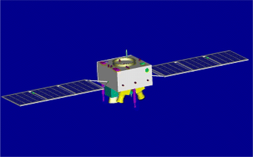
Figure 2. In-orbit status of the HJ-1B satellite.
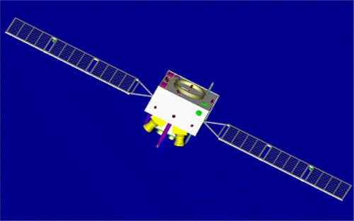
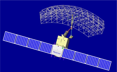
Figure 3. In-orbit status of the HJ-1C satellite.
HJ-1 satellites combine two identical CCD cameras that observe a broad coverage of 720 km and a high spatial resolution of 30 m. The CCD cameras have four visible and near-infrared bands, which include B1 (0.43–0.52 µm), B2 (0.52–0.60 µm), B3 (0.63–0.69 µm), and B4 (0.76–0.90 µm) and can obtain several key parameters of the atmosphere, water bodies, and land surfaces. In atmospheric monitoring, CCD cameras provide information on clouds, aerosols, and dust storms (Wang et al. Citation2011); in aquatic monitoring, CCD cameras are used to identify water bodies and monitor suspended matter, algae, and other aquatic plants; in land monitoring, CCD cameras can observe changes in land cover type, urban environments, vegetation and soil, grassland and farmland, desertification, as well as snow and ice cover (Wang et al. Citation2010).
The reflected or emitted signals from the Earth's surface are received by the IRS, and then converged through the optical system onto the linear array of detectors which carry out the photo-electric conversion. The electric signals output from the detectors are then converted to digital signals and are further processed through nonuniformity correction to generate the images of different bands. An IRS has four bands ranging from near-infrared to thermal infrared, including B1 (0.75–1.10 µm), B2 (1.55–1.75 µm), B3 (3.50–3.90 µm), and B4 (10.5–12.5 µm), which collect the infrared radiometric information from land surfaces, water bodies, and the atmosphere (Binding et al. Citation2008).
The HSI obtains hyperspectral data based on the Spatially Modulated Interference Fourier Transform hyperspectral Imager (SMIFTS) and takes the images of varied surfaces by using photo-electric conversion. The HSI utilizes a plane array CCD to simultaneously collect one dimension of spatial information and spectral signals and acquires the other dimension of spatial information by push-broom scanning. HSI covers the continuous spectral range from 0.45 to 0.95 µm, and the mean spectral resolution is 5 nm. Based on hyperspectral observations from the HSI, accurate classification in environmental monitoring can be achieved, and the complete spectral curves of surface targets in the visible and near-infrared range can be restored, which are very helpful to component analysis and detailed detection of environmental pollution (Giardino et al. Citation2005, Gupta et al. Citation2006).
The S-band SAR onboard the HJ-1C satellite works in a stripmap/scanning mode and is single-polarized with a VV (vertical transmit and vertical receive) channel. This S-band SAR can observe either a broad swath of 100 km with a horizontal resolution of 20 m, or a narrow swath of 40 km with a horizontal resolution of 5 m. The SAR measurements will be widely used in monitoring environmental impacts of oil spills in oceans, water bloom, red tide, land degradation, and natural disasters, which makes the HJ-1 satellites capable of monitoring the conditions and dynamic environmental changes under all weather conditions.
3. Application features of HJ-1 satellites
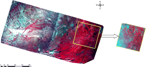
By combining the two wide field-of-view CCD cameras, each of which has a swath of 360 km, HJ-1A and HJ-1B can achieve broad coverage of 700 km. In addition, the IRS onboard HJ-1B also has a large swath of 720 km and thus coincides with the CCD data very well. Compared to Band 1 to Band 4 of Landsat ETM/TM with a swath of 185 km, the CCD cameras on HJ-1 satellites have the same spatial resolution (30 m) but a much larger coverage nearly four times that of ETM/TM. presents the direct comparison between a false color image from the combined CCD data of HJ-1A and that from Landsat TM data. It is clearly demonstrated that the HJ-1 satellites have great advantage in environmental monitoring of large-scale landscapes, and for most provincial units in China, each can be covered by one or two combined images of CCD and IRS of HJ-1 satellites. Therefore, HJ-1A and HJ-1B have good performance in monitoring water quality of large lakes and reservoirs, air quality of important city clusters, as well as in the surveying of environment, key ecological reserves, ecological construction zones, and large projects nationwide.
Figure 4. Comparison between a single false color image of HJ-1 satellites and that of Landsat TM.
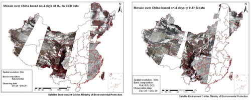
HJ-1A and HJ-1B operate in the same orbital plane, having a phase difference of 180° between each other, which reduces the revisit period of the CCD data from 4 (single satellite) to 2 days (two satellites combined). Based on the CCD data of HJ-1A and HJ-1B from 26 December to 29 December 2008, true color mosaics of China during one revisit period of a single satellite (4 days) are given in . It is shown that the CCD data from a single HJ-1 satellite is not enough to cover the entire land surface of China but can guarantee a fraction of 60–70%.
Figure 5. True color mosaic of the land surface of China based on the CCD data of HJ-1A (left) and HJ-1B (right).
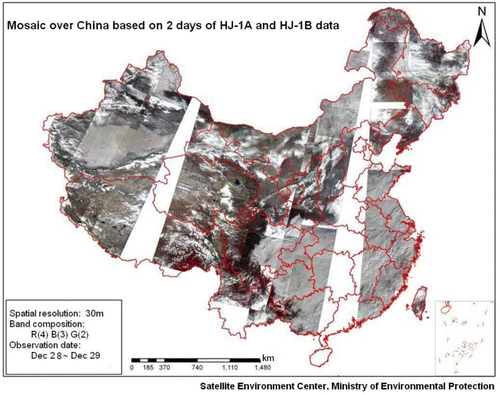
In , a true-color composite mosaic of China based on the combination of CCD data of HJ-1A and HJ-1B on 28 December and 29 December 2008 is presented, under which nearly 90% of the land surface of China is covered. One can see that, when neglecting the fraction of cloud cover, the complete coverage of land surface in China can be basically achieved within 2 to 3 days by combining CCD data from HJ-1A and HJ-1B. Compared to Landsat ETM/TM data and CBERS CCD data, of which the revisit period is 16 and 26 days, respectively, HJ-1 satellites have a much higher temporal resolution and thus can provide better data support for dynamic monitoring of nationwide environmental quality.
Figure 6. True-color composite mosaic of China based on the combination of two days’ CCD data from HJ-1A and HJ-1B.
To further investigate the data correlation between HJ-1 CCD and Landsat TM, a single image of HJ-1A on 8 October 2008 (path: 38, row: 61) and one of Landsat TM on 13 July 2008 (path: 143, row: 29) were selected for univariate statistics and multivariate statistics. From either image, 0.1% of the total pixels were randomly picked out for statistical analysis, and the sample size was 37,886 in all. The results of univariate statistics are given in , where several parameters were calculated for all four bands of the HJ-1 CCD, denoted as HJ-1 to HJ-4, and for the first four bands of Landsat TM, denoted as TM-1 to TM-4. Further, the covariance matrix of these eight bands is presented in .
Table 1. Parameters of univariate statistics of data samples from HJ-1 CCD and Landsat TM.
Table 2. Covariance matrix of data samples from HJ-1 CCD and Landsat TM.
The above statistical analysis indicates that there are high correlations between the bands of the HJ CCD and the relevant bands of Landsat TM, with which the mean correlation coefficient of the four bands of the two sensors is 0.84. All the correlation coefficients of Band 1, Band 2, and Band 3 are greater than 0.85, showing a very high consistency for these three bands of data from the two sensors. Data from Band 4 of the two sensors have comparably low correlation, but the correlation coefficient is still as high as 0.64.
4. Construction of the HJ-1 satellite ground operation system
The HJ-1 satellite ground operation system consists of several subsystems, such as data receiving, satellite and instrument control, operation and management, data processing, environmental applications, disaster reduction applications, and communication and data transmission (Wang Citation2010). The composition of the ground operation system is given in .
Figure 7. Composition of the ground systems of HJ-1 satellites.
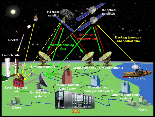
The receiving subsystem is made up of three ground receiving stations, including the Beijing Station, Northwestern Station, and Southern Station, and its major tasks include tracking satellites, receiving remote sensing data transmitted from orbit, preprocessing data such as amplification and demodulation, and then delivering data to the environmental application and disaster application subsystems.
The operation monitoring and control subsystem controls the onboard instruments. During either in-orbit testing or the operational stage, this subsystem controls the working conditions of all the instruments and receives, monitors, and records the telemetry data of the instruments, which is transmitted to the operation management subsystem to ensure the best working status of instruments aboard HJ-1 satellites.
The operation management subsystem is designed to: (1) make operation plans for the instruments aboard HJ-1 satellites, and arrange production schedules for the entire ground system; (2) record the telemetry data of instruments and sensors; (3) give directions and schedule tasks; (4) monitor and display the operating status of the applications systems; and (5) establish and manage several databases for operation archives, instruments, and engineering parameters, and make satellite user manuals. Also, it will support extensive applications of HJ-1 satellites by organizing comprehensive experiments for satellite radiometric calibration, and by providing coefficients of absolute radiometric calibration and key datasets from various experiments.
The main tasks of the data processing subsystem are as follows: (1) conduct preprocessing of the raw satellite data from ground receiving stations, such as data depression, format transformation, image subdivision, ancillary data processing, radiometric calibration, and geometric calibration; (2) implement the imaging and preprocessing of SAR data; (3) generate all levels of products required by users; (4) make catalogs and archives for raw data and products, and draw up standards of product quality; (5) examine the quality of all kinds of products; and (6) establish and manage the database of raw data and products.
The environmental applications subsystem utilizes the data from HJ-1 satellites and synthesizes ground-based measurements to drive the application system for environmental monitoring and prediction to give early warning of occurrences of environmental pollution and ecological damage, as well as to monitor and evaluate their development. Meanwhile, this subsystem provides local and remote users with services such as querying and distributing remote sensing products, and also provides timely and accurate remotely sensed information of environmental and ecological status for environmental protection administrations and other relevant agencies.
The disaster reduction subsystem synthesizes satellite data and ground-based measurements to drive the comprehensive monitoring and prediction system for natural hazards and give early warning for various hazards, in addition to monitoring and evaluating the events as they progress. This subsystem will generate and distribute data products for disaster reduction, and make relevant satellite-based simulation images for damage evaluation. It provides relevant agencies with the timely and accurate information they need to effectively reduce the effects of hazards and disasters.
The communication and data transmission subsystem is in charge of the internal and external transmission of data and commands. It is mainly made up of: (1) the specific telecommunication network of high-speed optical fiber connecting the Beijing Station and the subsystems of environmental applications and disaster reduction applications; and (2) the VSAT telecommunication network linking the Northwestern Station, the Southern Station, and the Xi'an Center of Satellite Tracking Telemetry and Control. All the subsystems of the ground application system are connected by a high-speed telecommunication network and joined as an organic body.
As shown in , the operation management subsystem of HJ-1 satellites takes the operational requirements of national environmental protection and disaster reduction and the users’ needs into account. It also works out satellite observation plans and product manufacturing plans, and gives control commands to satellites based on the working status of the ground application system and the data already received and processed. The encrypted control commands are sent to satellites through the Tracking Telemetry and Control Center, and the satellites will conduct Earth observation as requested once the input commands are received. If the satellite observation zone is not within range of a receiving station, the data will be recorded to onboard memory and sent back when satellites pass over the receiving range of a ground station. The ground stations prepare for satellite tracking and data receiving according to the receiving plans of the operation management subsystem; when the satellites enter the receiving range of ground stations, the stations capture the satellite signal with a radio tracking system, record the remote sensing data from the satellite, and transmit the received satellites’ baseband data to the data processing subsystem, the environmental application subsystem, and the disaster reduction application subsystem through a high-speed network. The environmental application subsystem and the disaster reduction application subsystem subdivide the transmitted remote sensing data and ancillary data according to the receiving plans of the operation management subsystem, and generate level-0 products and quick-view images. As the application subsystem receives product orders from superior departments or users, and provided that the database of the subsystem stores the satellite data required for product generation, the application subsystem will obtain level-0 data from the data catalog and archive subsystem according to the requests of the orders, generate all levels of products required by the users, and release the products to users. If the database of the subsystem does not store the satellite data required for product generation, the application subsystem will generate satellite data requests according to the contents of the orders, and submit the requests to the operation management subsystem. The operation management subsystem receives data requests from all the other subsystems, and based on the meteorological data acquired from the meteorological agencies, it works out the receiving schedules for all the ground stations, which are sent to the ground stations through a fiber-optic network. Ultimately, the ground stations transmit the received satellite baseband data to the environment applications subsystem and the disaster reduction applications subsystem through a fiber-optic network or tape. In case of severe environmental pollution incidents or major natural disasters, the application subsystem would skip the catalog and archive procedure in the normal working mode. Instead, it would conduct simple and rapid image processing after locating the image of the critical area on mobile window display equipment, and directly generate the required high-level products.
5. Construction and application of the Environmental Application System of HJ-1 satellites
The Environment Application System (EAS) plays a key role in carrying out the functions and yielding the products of HJ-1 satellites. The application goals of the EAS are to, by employing HJ-1 satellites as a primary data source and combining multiple sources of remote sensing data, (1) achieve large-scale, all-weather, constant, dynamic monitoring of surface water, ambient air, and macroecologies, (2) provide multi-level, comprehensive environmental remote sensing information and technical services, and (3) improve the ability to monitor and control the environment and serious pollution accidents (Wang Citation2010).
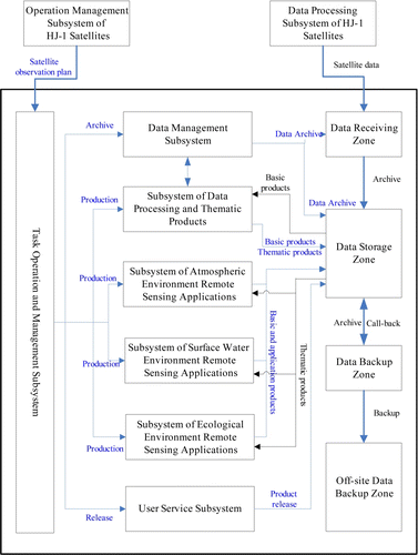
The infrastructure of the EAS adopts a multitier architecture design philosophy and its components are given in a top-to-bottom sequence, as shown in : information portals layer, application service layer, public service layer, application middleware layer, data resource layer, and support layer (Wang Citation2010).
Figure 8. General structure of the Environment Application System of HJ-1 satellites.
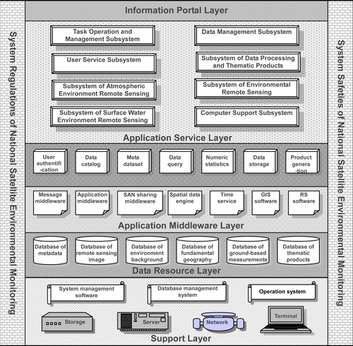
The information portal layer is the window of the EAS for providing remote sensing information to users, and users can acquire all levels of HJ-1 satellites’ remote sensing products online. The information portal layer integrates the browser/server parts of all the subsystems by conducting portal integration.
The application service layer is the software platform of the EAS, and it provides users with various functions and services through graphical elements, such as menus, toolbars and dialogs, and integrates these functions together into a tool that can directly interact with users and help them with routine tasks.
The public service layer provides reusable service modules as well as basic services that can be called by multiple subsystems. These public services are implemented through message services, which include data archives, queries, catalogs, metadata, user authentication, user information queries, basic image processing, and fundamental thematic products.
The application middleware layer provides the application service layer and public service layer with message middleware, time and log services, a geographical information system, a remote sensing image processing system, storage area network (SAN) file sharing, a spatial data engine, and other fundamental support services.
The data resource layer provides a public data environment for system operation, including databases for user services and information access, service operation and management, system maintenance, metadata, images, products, and an ancillary database, and it implements the management of many kinds of data. Based on uniform data regulations, the data resource layer provides an upper layer with uniform data models, a uniform data catalog mechanism, as well as uniform data archival and withdrawal.
The support layer provides the software and hardware environment for system operation, which consists of the computer operating system, database management system, system management software, servers, storage devices, and network devices.
According to the practical requirements of environmental satellite monitoring, the EAS is made up of eight subsystems: the task operation and management subsystem, data management subsystem, user service subsystem, image processing and thematic product subsystem, environmental remote sensing applications subsystem, surface water environment remote sensing applications subsystem, atmospheric environment remote sensing applications subsystem, and computer support subsystem.
The task operation and management subsystem functions as an interface between the EAS and the ground system of HJ-1 satellites. Its major duties include: (1) make various production plans and task schedules for the EAS; (2) control task flows and data flows among the subsystems, and carry out network monitoring and management; (3) set up connections between the EAS and task operation system of HJ-1 satellites, and plan the receiving of HJ-1 satellite data according to users’ task orders; and (4) manage data production plans and arrange system resources to complete the generation of all levels of products as well as quality control.
The data management subsystem mainly focuses on the staging, classification and management of HJ-1 satellite data and is capable of integrating, archiving, managing, sharing, and releasing massive amounts of data. This subsystem is the platform for users to easily and quickly query and obtain data, and the foundation of data sharing and value-added applications.
The data processing and thematic product subsystem generates data products mainly based on HJ-1 satellites and also employs the data from other satellites. It has capabilities for data quality analysis, examination of data radiometric and geometric calibration, and validation of remote sensing data from HJ-1 satellites. According to environmental characteristics, this subsystem implements operational production on a series of remote sensing parameters and generates thematic environmental imagery products, so as to meet the requirements of environmental monitoring.
By establishing external portals, the user service subsystem can release HJ-1 satellite products and environmental remote sensing information to the public, set up the sharing of catalog resources with other departments and external agencies, and make relevant adjustment to internal operations based on external users’ information collection requirements. Through the external portals, external users receive services by exploring, querying, ordering, and downloading HJ-1 satellite products and environmental remote sensing information. They can also interact with the EAS and acquire relevant HJ-1 satellite products and environmental remote sensing information by several means, such as web, multimedia, email, and CD. Meanwhile, this subsystem builds a uniform operational system portal that provides internal users with information query and display services of environmental applications. Based on the user service subsystem, internal users can look up environment archives, search for HJ-1 satellite products and environmental remote sensing information, and deal with operational tasks relevant to environmental applications.
The surface water remote sensing application subsystem employs multiple sources of remote sensing data from HJ-1 and other satellites for the acquisition, analysis, processing, and application of pollution information of surface water environments. It is capable of monitoring surface water environment parameters, such as chlorophyll, suspended matters, water color, and water bloom by remote sensing, and generate and distribute relevant information products.
The atmospheric environment remote sensing application subsystem utilizes multiple sources of remote sensing data from HJ-1 and other satellites to implement the monitoring of regional air pollution. This subsystem has the ability to monitor regional air pollutants, including aerosol optical thickness, particulate matters, haze, fog, crop residue burning, and dust storms by remote sensing, and can generate and distribute relevant information products.
The land environment remote sensing application subsystem monitors and evaluates nationwide ecological conditions based on multiple remote sensing data from HJ-1 and other satellites. This subsystem possesses several important functions, such as dynamically monitoring and evaluating natural reserves, environmental impacts of large projects or regional construction, comprehensive effects of national ecological construction areas, key ecological function zones, urban environments, regional ecological and environmental disasters, soil ecology, solid wastes, and global environmental changes.
Because of the operation schedules and product system of the EAS, a task-driven operation mode (as shown in ) was adopted for the EAS.
Figure 9. Task-driven operation mode adopted by the Environment Application System.
Based on the observation plans of HJ-1 satellites, the task-driven operation mode will make the EAS production plans and, under the coordination and management of the task operation and management subsystem, it will conduct geometric precision correction, data fusion, and mosaic processing on level-2 data, and generate high-level data, thematic products, and environment application products, completing the EAS production plans. Under the task-driven operation mode, those specific production tasks with single or relatively special functions are designed to be independent operation services of the EAS, and the production services of multiple products are provided to users. Based on the system's service capability, production task plans are made through the task operation and management subsystem, and then these plans drive relevant services so as to complete product generation and task operations. The task-driven operation mode is set up to cope with the complexity of the EAS. It guarantees the intercommunication and interoperability among the subsystems of the EAS, which not only avoids redundant construction but also makes best use of the system and takes full advantage of the software and hardware resources.
Notes on contributor
Qiao Wang received his BS degree in Mathematics from Nanjing University, Nanjing, China, and his MS and Ph.D. degrees in Cartography and Geographical Information System (GIS) from Wuhan University, Wuhan, China, in 1982, 1992, and 1996, respectively. From 1982 to 1996, he worked in Wuhan University as a lecturer and associate professor, working on the study of Cartology and GIS. He joined the Institute of Remote Sensing Applications (IRSA), Chinese Academy of Sciences, Beijing, and worked as a postdoctorate from 1996 to 1998. In 1997, he worked in TELESPAZIC, Rome, Italy, focusing on the research and development of remote sensing and GIS systems. He is a professor of IRSA and Nanjing Normal University, and a State Council Expert for Special Allowance. He works in the Satellite Environment Center, Ministry of Environmental Protection of China, as the deputy director and the general engineer. He is also the chief designer of the HJ-1 satellite application system and the director of State Key Laboratory of Satellite Remote Sensing for Environmental Protection. His research experiences include the study and applications of environmental remote sensing and GIS. He has published more than 20 books and over 200 papers in environmental remote sensing, spatial information models, and GIS.
References
- Binding , C.E. 2008 . Spectral absorption properties of dissolved and particulate matter in Lake Erie . Remote Sensing of Environment , 112 ( 4 ) : 1702 – 1711 .
- Giardino , C. , Candiani , G. and Zilioli , E. 2005 . Detecting chlorophyll-a in Lake Garda using TOA MERIS radiances . Photogrammetric Engineering and Remote Sensing , 71 ( 9 ) : 1045 – 1051 .
- Gupta , P. 2006 . Satellite remote sensing of particulate matter and air quality assessment over global cities . Atmospheric Environment , 40 : 5880 – 5892 .
- Wang , Q. 2010 . Ecological monitoring using remote sensing based on HJ-1 satellites , Beijing : Science Press .
- Wang , Q. 2010 . Project of environmental information system , Beijing : Science Press .
- Wang , Q. , Yang , Y. and Huang , J. 2005 . Remote sensing of environment , Beijing : Science Press .
- Wang , Q. 2008 . Monitoring experiment of aquatic environment in Taihu Lake using remote sensing and the software development , Beijing : Science Press .
- Wang , Q. 2011 . Technology and application of satellite remote sensing for atmospheric environment monitoring , Beijing : Science Press .