Abstract
The China Remote Sensing Satellite Ground Station was established in 1986. It currently has three receiving stations in the north, west, and south of China, with the capacity to receive data from 15 international and domestic Earth observation satellites covering the entire Chinese territory and 70% of Asia. Meanwhile, a systematic, integrated, and standardized spatial information service system has been built. A data-sharing project for medium-resolution Earth observation satellites has been conducted and plays an important role in land, ocean, and atmospheric resource investigation and environmental monitoring.
1. Introduction
The China Remote Sensing Satellite Ground Station (RSGS), established in 1986 and now operating under the Center for Earth Observation and Digital Earth (CEODE), Chinese Academy of Sciences (CAS), has the capacity to receive data from international and domestic satellites. It can provide a complete range of high- to low-resolution imagery as well as optical and radar image products, in essence realizing the goal for an all-weather, 24-hour, multi-resolution, spaceborne Earth observation (EO) information center in China. Combining the China Center for Resources Satellite Data and Application (CRESDA), National Satellite Meteorological Center (NSMC), and National Satellite Ocean Application Service (NSOAS), China has constructed a network operating system for acquisition of remote sensing satellite data (Guo Citation1998, Guo and Wang Citation2005). In this article, we introduce China's land observation satellite data receiving abilities and also the state of data sharing for remote sensing data.
2. Earth observation satellite data receiving system
2.1. Data receiving stations network
The China Remote Sensing Satellite Ground Station (RSGS) was formally established and became operational in 1986 with the completion of a ground station in Miyun, near Beijing. It was the first remote sensing satellite data receiving ground station in China. The first satellite to transmit data to RSGS was LANDSAT-5. Over the next 20 years, RSGS has been supporting the development of China's remote sensing applications by receiving and providing a variety of remote sensing data. In recent years, in order to expand satellite operations and reception coverage area, and to meet more users’ needs, Kashgar Station, located in Xinjiang Province in western China, and Sanya Station, located in southern China's Hainan Province, have been constructed. Together with Miyun Station, the three ground stations are a national satellite data receiving network and can receive remote sensing data covering the entire Chinese territory and 70% of Asia ().
Figure 1. Area covered by Miyun Receiving Station (upper-right), Kashgar Receiving Station (middle-right) and Sanya Receiving Station (lower-right).
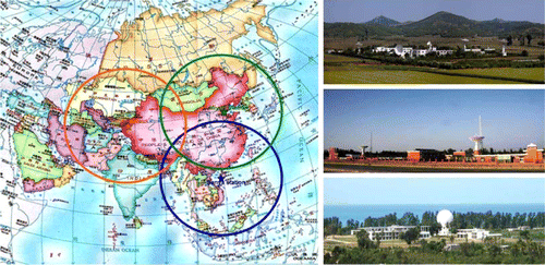
Miyun Station, located at 40°N/117°E in a suburb of Beijing, is approximately 100 km from downtown. It is surrounded by hills and has a wide field of view. Electro-magnetic interference is comparatively weak, and the landscape is beautiful. It was established and became operational in December 1986, comprising a total area of 5.7 ha, and its construction area is 7423 m2.
Kashgar Station, located at 39°N/76°E, is approximately 9 km away from downtown Kashgar. It was established and put into operation in January 2008, covering an area of 11.3 ha, and its construction area is 2990 m2.
Sanya Station, located at 18°N/109°E, is about 20 km west of Sanya. It became operational in January 2010. The station covers above 5.4 ha, and its construction area is 3260 m2.
2.2. Technical composition of the data receiving system
The EO satellite ground segment of RSGS is composed of a data receiving station system, data transfer system, and data receiving management and monitoring system. Its main tasks are data acquisition, recording, quick-look image generation, data transfer, reception resources management and control, and data quality monitoring.
The data receiving station system is distributed across three receiving stations. Its main equipment includes antennas, control and tracking systems, demodulators, and recording systems. Miyun Station has four medium to large antennas, with dish diameters of 10, 11, 6, and 12 m (ordered by the time of their construction). Both Kashgar and Sanya stations have two antennas with 12-m diameters. The work band of these antennas is X-band, and their receiving abilities are different due to the different apertures. The gain of these 12-m antennas is 35 dB, and they have polarization multiplexing capability in the X-band. At present, all the stations have the capability to receive data of up to 450 Mbps dual downlink. The following characteristics are some key parameters of the 12-m antennas:
| • | Reflector dish size: 12 m. | ||||
| • | Radio Frequency (RF) range: 8–9 GHz. | ||||
| • | X-band G/T at 5°: 35 dB/K. | ||||
| • | Storage of multiple satellite passes and satellite scheduling. | ||||
| • | High efficiency reflector shaped specifically for remote sensing. | ||||
| • | Omni semisphere S/X band auto tracking ability. | ||||
| • | Motorized, tilt, train pedestal configuration eliminates overhead pass ‘keyhole.’ | ||||
| • | Real-time moving window display. | ||||
| • | Real-time data transmission to data center. | ||||
| • | Dual polarization feed with high polarization isolation. | ||||
| • | High data rate demodulators and bits synchronizers, downlink data rates up to 2*450 Mbps. | ||||
| • | Centralized monitoring and control architecture. | ||||
The data transferring system is responsible for transferring the received data to CEODE headquarters in Beijing. At present, the bandwidth between Miyun Station and CEODE is 1 Gbps, and 155 Mbps from Kashgar and Sanya stations. The bandwidth of the data transmission channels will be expanded to 10 Gbps, 622 Mbps, and 622 Mbps, respectively.
The data receiving management and monitoring system is responsible for handling the control system for satellite programming and unified planning of the ground receiving resources. Its main functions are receiving generated tasks, data receiving system scheduling and data quality monitoring. It also supervises the working state of data receiving systems and business flows in real time, updates and summarizes status information of equipment in the receiving system, and reports on task execution.
2.3. Data receiving tasks of remote sensing satellites
The Center for Earth Observation and Digital Earth (CEODE) is now undertaking the task of receiving remote sensing data for both Chinese and important international satellites. The domestic satellite receiving tasks are designated by the government, while the international satellite receiving tasks are based on cooperation agreements signed between CEODE and the agency operating the satellite ().
Table 1. Satellites received by the ground station network: past and present.
Because it was constructed first and its coverage involves the most developed economic zone of China, Miyun Station receives the largest number of satellites. The station can receive China's HJ series satellites, China-Brazil CBERS series satellites, China's ZY-3 satellite, LANDSAT series satellites, SPOT series satellites, ENVISAT and ERS series satellites, RADARSAT series satellites, RESOURCESAT, THEOS, and others. Its spatial range of data receiving covers eastern, central, and northeastern China, and the adjacent overseas regions.
The remote sensing satellite data received by Kashgar Station are from China's HJ series, ZY-02C, and ZY-3, as well as international satellites including LANDSAT-5, SPOT2/4, RADARSAT-2, RESOURCESAT, and THEOS. The main receiving area covers western China and the adjacent overseas regions.
Sanya Station mainly receives remote sensing data from China's HJ series, ZY-02C and ZY-3, as well as THEOS. Its spatial coverage mainly includes the southern and adjacent overseas territories of China.
3. Data processing system for Earth observation satellites
Based on continuous development in the past few years, CEODE has one of the most advanced data processing systems in the world for international EO satellites, as well as the capacity for efficient data processing and production.
3.1. Advanced data processing system
Due to their sensors' high quality and reliable provisioning of data, advanced international EO satellites, such as LANDSAT, SPOT, and RADARSAT, have been widely used in the fields of land resources, agriculture, forestry, environmental science, oceanography, surveying and mapping, geology, and disaster monitoring in China since the 1980s.
There are six sets of advanced EO data processing systems for these satellites at CEODE, all of which have been making significant contributions to EO in China. The international spaceborne remote sensing data used in China are mainly processed by these systems.
When the LANDSAT-5 processing system became operational in 1986, it was the first time for Chinese users to acquire and use international satellite data directly. ERS-1 and JERS-1 data processing have been providing all-weather, 24-hour observations since 1992. In 1997 and 2008, RADARSAT-1 and 2 products, which are characterized by multi-mode imaging, polarization, and 3 m spatial resolution, led the most advanced civil spaceborne Synthetic Aperture Radar (SAR) applications in China. SPOT-5, launched in 2002, became one of the most successful EO satellites in the world because of its multiple operation modes, higher resolution, and reliable operation.
By now, the data processing systems are all in normal operation at CEODE, acting as reliable data resource providers. The characteristics of the related EO data are:
| • | Multiple types and modes: optical and SAR, spatial resolution from 2.5 to 100 m. | ||||
| • | High-quality data: advanced radiometric and geometric correction. | ||||
| • | Standard, certified product formats: identical to other countries and feasible for data exchange. | ||||
| • | Reliability for data acquisition: emergency data ordering and acquisition for users. | ||||
In order to match the increasing requirements for EO data resources from national users in the next five years, CEODE will continue building data processing systems and new data resources. The THEOS ground segment became operational in 2011, bringing a new, advanced international satellite into the EO field in China. Coming in 2012 are RADARSAT-2 SPOTLIGHT mode and SPOT-6 production, which will increase the spatial resolution of products by approximately 1 m.
3.2. Independent development for efficient data processing and production
As a part of the ‘National key science and technology basic facilities,’ CEODE accomplished a series of important innovation projects in recent years. The results are not only a great promotion for data reception, processing, archiving, querying, and value-added production capacity, but also for achieving an efficient framework for data processing and production.
The project ‘Data processing and archiving system for multiple satellites’ strives for technical innovation in current processing systems, building archiving systems for the huge amount of EO data, developing advanced operation management and control systems, and integrating different processing systems. After the project, the operation of data processing and production will become more and more efficient.
The cataloging and browsing system, data sharing service system, and data distribution system are running well after development. The new version of the web service system for data users is being developed now. Based on these systems, the online data services of CEODE will become more reliable.
High-level processing and value-added production are also new highlights, enlarging the product categories and service range. Based on technology and system innovations, for example, an automatic image ortho-processing system, the trend of product promotion is progressing from low to high.
By now, the whole procedure has already become fully automated from determining user requirement to product delivery. The time duration limit of product delivery can be within one or two hours from the time of the downlink, which meets the needs for a fast response in remote sensing. An outstanding example is that CEODE has supported national, near real-time marine monitoring for years.
In order to protect archived data, CEODE built a data backup and recovery system at Miyun Station that provides technical support for archiving historical data reliably, performing dynamic backups and quickly recovering data.
4. Earth observation data sharing and applications
4.1. Data sharing
Since the beginning of the twenty-first century, with an ambitious national plan for future development, especially the implementation of a series of important deployments for EO, great opportunities for development have arisen. The demand for satellite remote sensing data is increasing sustainably and rapidly (Chen and Guo Citation2003).
In order to satisfy the fast-growing demand for EO data in various fields at the national level, CEODE actively researches and explores new forms of user services. Data sharing for national users is the most important new initiative. After the Wenchuan Earthquake (2008) and Yushu Earthquake (2010), CEODE provided near-real time aerospace remote sensing data through different forms and mechanisms. Thus, huge amounts of data were provided continuously to decision-making departments, which effectively enhanced the technical support of remote sensing for Earthquake relief and earned high regards from the national leadership, all levels of government as well as the international community.
In March 2011, CEODE resolved to fully implement the national user-oriented ‘Earth Observation Data Sharing Plan (EODSP).’ EODSP shares 23,000 scenes of medium-resolution, space-borne remote sensing data, including LANDSAT-5, LANDSAT-7, RESOURCESAT-1, ERS-1/2, and ENVISAT-1, to national users in two ways: free online access and special service agreements for key state projects. The implementation of EODSP achieves a significant change in and innovation of CEODE's user service model (CEODE Citation2011).
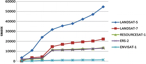
By the end of 2011, the online service platform of EODSP had run 260 days with 9118 certified user registrations, 103,381 total visits, and 105,228 scenes downloaded totaling 19,533 GB of data ().
Figure 2. Statistics of different satellite data downloaded by EODSP users (accumulated monthly).
Since the implementation of EODSP for future national development and strategic demand, it has played an important role in the field of EO and brought significant social benefits.
Through CEODE's shared data, the Chinese Academy of Surveying and Mapping and its affiliates carried out a national geographic condition survey, the 863 project ‘Away From the Mainland Island (Reef) Remote Sensing Identification and Mapping Technology,’ and independent research on innovative topics. Thus, technology, methods, processes, and standards were formed for thematic extraction of transportation, water systems, urban, and vegetation cover.
The Rural Department of the National Bureau of Statistics and Beijing Normal University are developing the 863 project ‘Remote Sensing Survey for Grain Planting Area and Estimation System of Production in National Grain Producing Areas’ to obtain maps of farmland and autumn grain planting spatial coverage in the research area. Due to the application of the research results, statistical remote sensing studies will be gradually promoted in national grain producing areas, so that remote sensing technology enters national statistics surveying projects.
The China National Environmental Monitoring Center carries out ‘National Ecological Environment Monitoring and Assessment’ research. It is expected that the national ecological environment quality assessment report (NEEQAR) will be completed in June 2012. The NEEQAR outlines ecological conditions of the nation and that in all provinces and counties. In addition, as internal data of the Ministry of Environmental Protection, NEEQAR will provide technical support for environmental management and decision-making.
We believe that, with the sustainable development of EODSP, the wide use of EO data will be further promoted in various industries in China, the level of the national remote sensing user services provided by CEODE will be continuously improved, and important contributions will be made to China's economic construction and social development.
4.2. The application of remote sensing satellites
Earth observation satellites greatly promote Chinese remote sensing applications ranging from scientific research to practical and operational use. There are more than 800 frequent users of remote sensing data, involving many sectors. By applying remote sensing technology, China has achieved great progress in the areas of land and resource surveying and monitoring, and estimation of serious natural disasters, estimation of major crop yields, urban expansion analysis, railway construction, mineral exploration, mapping, forest surveying, and planning. The amount of data used stand among the highest in the world. Since the direct reception of the first satellite transmission, remote sensing satellite data have been utilized in a wide range of fields. Some highlights of the application have been provided below.
1987 – monitoring of forest fire in Daxinganling.
1998 – flood monitoring for the Yangtze River and Songhuajiang River.
Since 1999 – large-scale, yearly national land resources investigation.
Since 2005 – Resource, environmental, and ecological investigation.
Since 2006 – Routine monitoring of the Bohai Sea oil spill.
2006–2010 – Western China surveying and mapping.
2008 – Wenchuan Earthquake damage evaluation.
With spaceborne EO data, China established an environmental resource database at scales of 1:100,000 and 1:500,000 and completed the country's land utilization survey at scales of 1:100,000, 1:250,000, and 1:1,000,000. On this basis, China also finished the investigation of nationwide soil erosion. The topographical map was updated at scales of 1:100,000 and 1:50,000, and in some areas, 1:10,000. In addition, a monitoring and yield estimation system for major crops was preliminarily set up in China and has begun to play an important role in estimating crops yields, monitoring farming, and guiding farming work, grain supply, import, and export.
A special example is the application of remote sensing technology in monitoring farmland occupation. China began economic reforms some 30 years ago and since then has experienced unprecedented development. Construction sites can be seen everywhere in China. The large-scale building of infrastructure improved cities’ functions and raised people's living standard. But at the same time, the rapid urbanization occupied arable land. China has a very large population, and the utilizable land per person is very limited. Each administration has always attached great importance to guaranteeing the supply of grain. Historical practices demonstrated that relying only on the traditional manner of land use change surveying cannot guarantee timely and accurate reports of land data for every region. In order to precisely understand the situation, Chinese land and resource authorities launched a program titled ‘99 Land Utilization Dynamic Remote Sensing Monitoring’ 10 years ago. With data from more than one thousand remote sensing images over a period of four months, the occupation of farmland by urban development in 66 cities with over 500,000 people from October 1998 to October 1999 was analyzed. The cities surveyed accounted for 78.6% of Chinese cities with over 500,000 people. The monitored area was 710,000 square kilometers, covering 7.4% of Chinese land, and the farmland within the monitored area was approximately 19.5% of the total farmland in China. Adopting mature technologies, the program was successful in carrying out monitoring in large areas, fully describing the overall situation of urbanization and land occupation by urban expansion, and providing the basis for scientific decision-making by the government. The Chinese government surveyed key cities every year from 1999 to 2010, progressively establishing a dynamic monitoring system for the country's land utilization and improving regulations for land utilization surveying, monitoring, and statistics.
Another typical example of the application of remote sensing data is on ecological quality assessments, which is one of the most important functions of the Ministry of Environmental Protection of China. The main task is to supervise the status of ecological quality and its change each year, and to provide a scientific basis for decision-making on ecological protection and management (Liu et al. Citation2009). This work has been put into the scope of a national environmental monitoring network, and has become a routine monitoring task. Since 2005, national annual ecological quality reports have been published every year. As an important part of environmental monitoring, ecological monitoring emphasizes the combination of ground monitoring and remote sensing, the combination of key regional and nationwide monitoring, and the combination of annual and real-time monitoring. Remote sensing satellite data play an important role in this task, which primarily uses remote sensing supported by ground checks. Ecological quality at the provincial, prefecture, and county levels are evaluated with uniform evaluation standards each year mainly using LANDSAT data supplemented with other similar data. This may include a combination of multi-source data such as environmental statistics, socioeconomic data, water resources, and land use. Remote sensing satellite data have provided great support for ecological quality assessments. According to statistics by the Ministry of Environmental Protection, 428 LANDSAT scenes were used in 2008 and 520 scenes were used in 2009.
5. Conclusion and discussion
With the rapid development of the economy and increasing demands on remote sensing satellites, it is necessary to form an operational, space-based observation system with the capability of all-weather observation, massive data operations, near real-time data acquisition, and a wide range of Earth surface observation. As a series of EO satellites will be launched by China step by step in the next 10 years, including resource satellites, environmental satellites, and surveying and mapping satellites, Chinese remote sensing satellite ground stations will receive and process even more data from more satellites. In order to meet this challenge, there are some improvements to the whole land observation satellite system that should be made in the future. On the data receiving technology aspect, network operation and management technology should be further enhanced, and the downlink rate a receiving system can handle should reach 2.5 Gbps. Meanwhile, more stations need to be built. Together with the current three facilities, the station network should receive and process more remote sensing data more quickly, putting it in a better position to meet the future needs of worldwide observation. In short, the aim of the receiving system of China's EO satellites is not only to provide services for China's development, but also make a significant contribution to global EO.
Notes on contributors
Huadong Guo is the Director-General and professor at the Center for Earth Observation and Digital Earth (CEODE), Chinese Academy of Sciences. He has been engaged in remote sensing research since 1977, devoting to researches on radar remote sensing, earth observation applications and digital earth science.
Jianbo Liu, Professor at Center for Earth Observation and Digital Earth (CEODE), Chinese Academy of Sciences. His working area is satellite ground station engineering, specialized in remote sensing image processing, data management and distribution.
An Li has been working on data reception and processing for the remote sensing satellites since 1989. He is now the professor at the Center for Earth Observation and Digital Earth (CEODE), Chinese Academy of Sciences, mainly involved in ground station engineering and operation.
Jianguo Zhang, Professor at CEODE, Chinese Academy of Sciences. His working area is satellite ground station engineering, specialized in receiving system design and signal processing.
Acknowledgements
This work is supported by National Natural Science Foundation of China (No. 60972141).
References
- CEODE , 2011 . Earth observation data sharing plan, in 2011 . Annual Report .
- Chen , S.P. , and Guo , H.D. 2003 . Remote sensing application and digital earth, science progress in China . In : Y.X. Lu Beijing Science Press .
- Guo , H. 1998 . Remote sensing in China: an overview and future development . Space Forum , 2 : 105 – 116 .
- Guo , H.D. and Wang , C.L. 2005 . Building up National Earth Observing System in China . Journal of Applied Earth Observation and Geoinformation , 6 ( 3–4 ) : 167 – 176 .
- Liu , H. , Dong , G. and Zhang , J. 2009 . LANDSAT data application in National Ecological Environmental Quality Assessment, users’ notes . CEODE , 3 : 2 – 3 .