
Abstract
Chinese tamarisk (saltcedar) is a deciduous shrub that occurs widely across the Yellow River Delta in China. The spatial structure of Chinese tamarisk is believed to have an influence on the landscape and habitats of rare birds. In this study, first, Chinese tamarisk is detected using Canny edge detector and mathematical morphological operators based on SPOT 5 fusion-ready imagery. Then the numbers, areas, locations, and patch spacing of Chinese tamarisk patches are calculated. The experiments show that the detection accuracy of Chinese tamarisk patches is about 93.4% after the disconnection of connected patches. The distribution orientation of about 70% of the patches is approximately south–north. About 91% of the minimum distances among the patches are between 12.5 and 57.5 m. The rose graph indicates that the main azimuth between patches is north–northwest, and the second is northeast and southeast. The present study indicates that the integrating Canny edge detector with the algorithms for extracting circular and elliptical objects based on mathematical morphology is simple and effective for detecting Chinese tamarisk patches and is easy to identify the spatial structure of Chinese tamarisk patches, which reduces the time and labor for the visual interpretation of Chinese tamarisk patches.
1. Introduction
Digital Yellow River Delta is one of the important components of Digital Earth which has been monitored by National Aeronautics and Space Administration (NASA) of USA through the Earth Observatory's mission. During the construction processes of Digital Yellow River Delta, it is important to use remote sensing data to monitor plant species and their dynamic changes in the Yellow River Delta. Chinese tamarisk (saltcedar) is a deciduous shrub or a small tree that occurs widely in patches across the Yellow River Delta in China, covering about 17,900 ha of the natural reserve of the Yellow River Delta in 1995 (Liu and Drost Citation1997). Saltcedar can tolerate heat, cold, drought, flood, and high concentrations of dissolved solids (Everitt Citation1980). Significant studies on saltcedar as an introduced invasive plant species have been implemented in North America (Cui et al. Citation2010). However, saltcedar and other species of the Tamarisk genus are considered as beneficial plants in China as windbreaks for preventing desertification and erosion in arid areas of northwestern China (Yang et al. Citation2006). In the Yellow River Delta, it is a native plant and useful for water conservation and soil stabilization and as the habitat of rare birds. To facilitate the monitoring of saltcedar and quantify the effects of the spatial structure of saltcedar on rare birds’ habitats, there is a clear need for accurate and economical methods of detecting and mapping saltcedar.
Traditional methods for detecting saltcedar, including field and aerial surveys, tend to be expensive, difficult to repeat, and more suitable for smaller areas. Remote sensing can provide information on the spatial and temporal distribution of plant populations in an efficient and cost-effective way (Shaw Citation2005), and has been used to map tamarisk. In general, the use of remote sensing techniques to map tamarisk mirrors the developments in remote sensing applications (Griffith et al. Citation2005). The work of Everitt and Deloach (Citation1990) demonstrated that late fall–early winter variations in the leaf color of saltcedar can serve as the basis for saltcedar identification, using photography and videography. Subsequent work by Everritt focused on the use of color and color infrared (CIR) aerial photographs and computerized processing to confirm and expand the utility of seasonal color variation (Everitt et al. Citation1996, Citation2001). Landsat thematic mapper (TM) imagery and ancillary geographic information system (GIS) data have been used to map saltcedar distribution in Nevada (Sengupta et al. Citation2005), and it was found that winter leaf-off Landsat TM imagery aided classification (Groeneveld and Watson Citation2008). Landsat TM was used to directly detect and classify tamarisk populations at the mouth of the Yellow River Delta in China (Fang and Xu Citation2000). Saltcedar defoliation by beetles had been mapped in Utah using ASTER imagery (Dennison et al. Citation2009). A number of saltcedar mapping applications have emerged more recently that rely on high spatial resolution (Akasheh et al. Citation2008) or on hyperspectral (Hamada et al. Citation2007, Yang et al. Citation2010) or time-series remote sensing methods (Evangelista et al. Citation2009, Cord et al. Citation2010). Ge et al. (Citation2006) used texture analysis for mapping tamarix parviflora based on aerial photographs along the Cache Creek, California, and demonstrated that texture could be used to improve the separability between invasive tamarix parviflora and associated vegetation, and texture features were useful in developing a relatively automatic procedure for detection and recognition of tamarix using historical color aerial photographs. Carter et al. (Citation2009) compared the efficacy of Landsat 5 TM, QuickBird (QB), and EO-1 Hyperion data in discriminating the tamarisk populations near De Beque, Colorado, USA, and proved that multispectral data at high spatial resolution (QB, 2.5 m ground spatial distance) were more effective in tamarisk delineation, with an overall classification accuracy of up to 91%.
Despite the successes in the reported studies, saltcedar detection from remotely sensed imagery is not always easy (Yang et al. Citation2010). Mapping tamarisk in the above reported studies was based on differences in spectral reflectance between tamarisk and associated vegetation. In fact, because saltcedar often occurs in patches, the geometric differences between tamarisk and background can be used to detect the tamarisk, that is detecting the tamarisk based on mathematical morphological methods. Because the artificial objects have a distinctive shape, mathematical morphological methods often are used to detect and identify them (Yang et al. Citation2009, San and Turker Citation2010, Skurikhin Citation2010). For natural vegetation, Perez et al. (Citation2000) used color and shape analysis techniques for weed detection in cereal fields; McGlynn and Okin (Citation2006) used an object-oriented classification to detect the shrub distribution; and Vogt et al. (Citation2007) mapped spatial patterns with morphological image processing. However, few studies use mathematical morphology (MM) to detect tamarisk. Our objective of this study was to: (1) to detect the circular or elliptical saltcedar patches from SPOT 5 fusion-ready imagery using mathematical morphology; and (2) to calculate the spatial structure parameters of saltcedar patches, such as the numbers and areas and directions of patches and the distance and azimuth between the patches.
2. Materials and methods
2.1. Study area
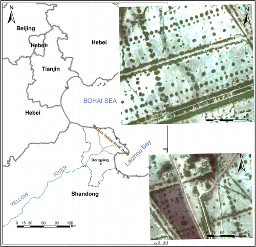
The Yellow River Delta is located north of Shangdong Province, China (shown in ). It was formed by the Yellow River, the second largest river in China, which has flowed into the Bohai Sea since 1855. The Yellow River Delta nature reserve was established by the central government in 1992 to protect the young wetland ecosystem. With its high primary production, the wetland offers a variety of habitats for birds, crabs, shellfish, and other animals, including many rare species (Fang and Xu Citation2000). The area has the monsoon climate in warm-temperate zone with four distinct seasons. The mean annual temperature is 11.9°C, the average annual precipitation is 530–630 mm, and the average annual evapotranspiration is 1900–2400 mm. The most common soil is Gleyic Solonchaks with high salt content in the tidal flats. The Suaeda salsa, Chinese tamarisk, and Reed are the three main native species which occur widely across the Yellow River Delta. The study area is part of Gudong oil field, located in the northeast of the Yellow River Delta, the experiment image in the lower right of covers about 56 ha, and the test image in the upper right of covers about 100 ha (shown in ).
2.2. Remote sensing data
The SPOT 5 satellite was placed in orbit in May 2002 and is the fifth of five SPOT satellites. The SPOT image is a view of the Earth seen through one of the satellite's high-resolution imaging instruments in five spectral bands (Multispectral: Band 1 (green, 500–590 nm); Band 2 (red, 610–680 nm); Band 3 (near infrared, 780–890 nm); Band 4 (short-wave infrared, 1580-1750 nm); P (panchromatic, 480-710 nm)). By combining imagery from all five SPOT satellites, it is now possible to generate data at four levels of resolution (2.5, 5, 10, and 20 m) in black and white and in color across the same 60 km swath (Spot Image Company Citation2010). Spot Image is now offering SPOT Globe products for use in Google Earth Enterpise, and SPOT Globe products are fusion-ready data-sets that are ready for use in Google Earth Enterprise. Over 15 million km2 of SPOTMaps products, Spot Image's high-quality 2.5-m natural color seamless mosaic products, are now available and ready-to-use in your Google Earth Enterprise system (Spot Image Company Citation2011). With Google Earth used widely, SPOTMaps product in fusion-ready format will be often used and popularized. Therefore, part of fusion-ready SPOT 5 image with the resolution of 2.5 m (acquired on 7 September 2005; 300×300 pixels; area is about 56 ha) was selected as the experiment image, which was bought from Spot Image Company (shown in ).
2.3. Mathematical morphology
According to Soille (Citation1999), MM can be defined as a theory for analysis of the spatial structures. It is morphological because it examines the form of objects and mathematical in that the analysis is based on an adjusted theory, geometry, and algebra. However, MM is not just a theory but also a powerful technique for the analysis of images. Although MM can be used in color images, it was often used to investigate geometric structure in binary and grayscale images. In general, there are two methods for transforming the high spatial resolution color images into binary image. The first is to produce a binary image from differences in spectral reflectance between the interesting objects and the background by selecting the appropriate thresholds or supervised and unsupervised classification. Because the spectra of the interesting objects, especially natural vegetation, and the background can be difficult to distinguish, some interesting objects may be removed and non-interesting objects kept in the binary image, leading to poor detection results using MM. The second general approach is to produce a binary image based on differences in geometric shape between the interesting objects and the background by finding edges of targets in the image, thus avoiding the errors from the mixing spectra between the interesting objects and the background. However, the errors would come because the gray level of the background is not a single value, so the image enhancement is necessary prior to edge detection. In this study, image enhancement and the edge extraction and elliptical object identification are used to detect saltcedar patches in SPOT 5 high spatial resolution fusion-ready image.
2.4. Image enhancement
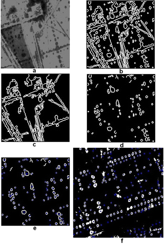
Firstly, the experiment image is transformed into the gray image by using the RGB2GRAY Function in MATLAB software. In the experiment image, at least the dark and bright backgrounds exist. If the edges are extracted directly, saltcedar patches in the dark background are difficult to be detected. Because the dark background is a small part of the image and the contrast between saltcedar and the dark background is small, the image enhancement is done on the dark background before the edge extraction. The gray-level range of the dark background is about from 40 to 150, which is stretched to the range from 0 to 130; meantime, the bright background also is stretched to 125. Therefore, the dark background is weakened and the saltcedar patches are enhanced (as shown in ). Finally, Wiener filter (3 by 3 window) is used to remove the noise of the gray image after the image enhancement (as shown in ) and further to enhance the contrast between saltcedar patches and background in order to improve the connectivity of the edges detected by the following method.
2.5. Edge extraction
There are many edge detectors in image processing. Ali and Clausi (Citation2001) reviewed the different edge detection techniques in image processing and concluded that the implemented Canny edge detector presented the best performance both visually and quantitatively. The Canny edge detector was developed by John Canny in 1986 and uses a multi-stage algorithm to detect a wide range of edges in images (Canny Citation1986). The Canny edge detector uses the Laplacian operator and can detect the strong and thin edges through using two different thresholds, respectively, which is easy for detecting the thin edges (Xu et al. Citation2002). Therefore, the Canny edge detector is used to detect the edges in this study, as shown in , which finds out most of the saltcedar patches’ edges in the experiment image.
2.6. Detection of saltcedar patches
First, the big stripe and rectangle patches and non-interesting objects are removed according to the area threshold of targets. Therefore, the following detection calculation time and workload can be reduced. According to the field survey statistics of saltcedar patches, the area of singe saltcedar patch is generally less than 1257 m2, i.e. less than 64 pixels, and the area of the vegetation stripe composed of saltcedar, Reed, Suaeda salsa, and other vegetation is often greater than 5000 m2, i.e. more than 250 pixels. Therefore, the area threshold of non-interesting targets is set to 300 pixels for removing the non-interesting objects and avoiding removing the patches connected by the thin stripes. But some patches connect with each other by the thick stripes, and their areas are probably greater than 300 pixels; therefore, they are falsely removed (for example, the circle patch in the lower left of ). shows the image after removing the non-interesting targets. Because the connectivity between the patches produces irregular shape and reduces the detection accuracy, the connected patches are separated before the detection of saltcedar. (Trace the exterior edges of targets and label the targets.) Meantime, the centroid coordinates and areas of the targets are calculated and saved.
Finally, the row and column coordinates of targets are calculated and saved. Then the height and width and actual areas of targets are calculated through accumulation of pixels of targets, and the theoretical areas of the targets are also calculated according to the area equation of ellipse. The ratio between width and height and the ratio between the actual and theoretical area of each target are calculated.
When the ratio between the actual and theoretical area of the target is between 0.4 and 1.25, saltcedar patches are detected very well and the number is 99 (). When the ratio between width and height of the target is less than 1.0, the orientation of the target is approximately south–north; when the ratio is greater than 1.0, the orientation of the target is approximately east–west; and when the ratio equals to 1.0, the target does not have the obvious orientation. The orientation of 69 out of the 99 patches is approximately south–north, and the other 30 patches is approximately east–west, which indicates that the approximate south–north orientation is predominant for saltcedar patches in the study image.
2.7. Calculation of spatial structure parameters
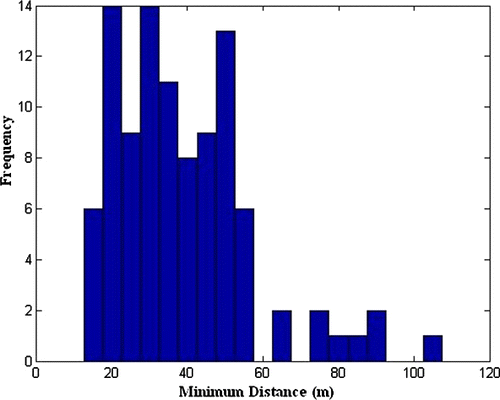
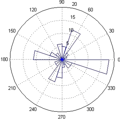
A given landscape structure may be described using the number and area and distribution of patch and the distance between patches and fractal dimension and so on (Jorge and Garcia Citation1997). The distance between patches can be described by measuring the minimum distance from centroid to centroid, as shown in . The azimuth between two patches that are at the minimum distance from each other can be calculated by measuring the angle from centroid to centroid, as shown in .
3. Results and discussion
3.1. Results
The actual number of saltcedar patches, determined from visual interpretation of , is 106. The detection accuracy is thus about 93.4% after disconnecting of connected patches (the ratio between the number of detected patches and actual patches (99/106)). To validate the methodology in this study, the same approach is used to detect saltcedar patches in the test image, with 204 patches detected (as shown in f) at an accuracy of 92.7%. Thus, the method in this study is very good for detecting the circular or elliptical saltcedar patches. Object-oriented image analysis provides many advantages over traditional pixel-based classifications (Geneletti and Gorte Citation2003), and its classification procedure can account for the spatial relationship of pixels, not just the spectral values. This method is gaining increasing acceptance as it proliferates throughout the remote sensing community (Dorren et al. Citation2003). Compared with the results from object-oriented image classification (Scale level =50; Merge level = 39; No thresholding) done in ENVI EX software (ENVI 4.7), the object-oriented classification results of the experiment image without image enhancement are worse than the results reported in this study, and its detection accuracy is 89.6%. Although most of the vegetation patches are extracted, many saltcedar patches in the dark background are not detected. The object-oriented classification results of the test image are the same as the results from this study; the vegetation patches are extracted well, and its detection accuracy is 92.1%. But more saltcedar patches closely around the big stripes are removed because the spectral difference among the saltcedar patch, the big vegetation, and the ground between them is small. In fact, when the large spectral difference between saltcedar patch and background in the image exists, detection of saltcedar patches is easy; and the object-oriented classification, unsupervised classification, and the proposed method in this paper can detect the saltcedar patches very well. If the calculation time and workload are not considered, the step to remove the non-interesting target (see Section 2.6) can be cancelled, and the non-interesting target can be removed based on the ratio between the actual and theoretical area of the target. Therefore, the proposed method in this study not only can quickly detect the saltcedar patches well without manual intervention (extracting features in ENVI EX needs human–computer interaction, for example, choosing segment scale level and merge level, classification by creating rules or selecting example interactively), but also calculate the area, shape, azimuth, and spatial structure of the saltcedar patch.
Many of the circular or elliptical patches in the experiment image are distributed along lines running in either a northwesterly or northeasterly direction, and some of the circular or elliptical patches are clustered together, which reflects the different habitats. The minimum and maximum area of the patches is about 50 and 1206.25 m2, respectively, and the area of about 60% of the patches is between 115 and 415 m2. The histogram and accumulative histogram of the minimum distance between patches show that the distances vary from 14.7 to 102.8 m, and about 91% of the minimum distances between patches range from 12.5 to 57.5 m. The rose graph indicates that the main azimuth between one patch and another patch at the minimum distance is north–northwest, and the second is northeast and southeast, which reflects the distribution characteristics of saltcedar patches in the image.
3.2. Analysis of the detection errors
The detection errors are mostly caused by three factors. First is failure to discriminate between patches of saltcedar and the background, and errors distinguishing the interesting patches from non-interesting targets. For example, the patches in the upper left corner of the experiment image are not identified because grayscale values of saltcedar patches and background in the image are mixed. Two such patches are not detected during the edge extraction. The northeast–southwest stripes also coincide with some small patches that are not easily separated from the circular or elliptical patches, leading to five patches being omitted. Second is the connectivity between patches which causes six of the patches shown in d to not be detected. e shows the results after disconnecting of the connected patches. The third factor is the noise in the image after non-interesting targets have been removed, which could be reduced by the use of smoothing filters.
3.3. Discussion
To detect the vegetation patches is significant. The experiments in the study area, implemented in MATLAB 7.0, show that integrating the Canny edge detector with the algorithms for detecting circular and elliptical objects based on MM is a simple and effective approach for identifying Chinese tamarisk from SPOT 5 high spatial resolution fusion-ready image. After the analysis of detection errors and the improvement of the algorithms, the detection accuracy for saltcedar patches with a distinctive shape could be improved in the future. In addition, color image edge detection and texture analysis techniques should be considered in order to improve the detection accuracy. Compared with the conventional pixel-based classification and object-oriented classification, the proposed method in this study not only can quickly detect the vegetation patches well with very little human intervention, but also count the area, shape, azimuth, and spatial structure of the vegetation patch. The numbers, areas, centroids, and the orientations of the patches, and the distances and azimuths between patches found in the experiment are important parameters for landscape ecology and spatial pattern research of plant species in the study area, and need to be studied in further detail in the future.
Acknowledgements
This research work was jointly supported by a grant from the National Natural Science Foundation of China (Project No. 41023010) and a grant from the Strategic Priority Research Program of Chinese Academy of Sciences (Project No. XDA05050601).
References
- Akasheh, O.Z., Neale, C.M.U., and Jayanthi, H., 2008. Detailed mapping of riparian vegetation in the middle Rio Grande River using high resolution multispectral airborne remote sensing. Journal of Arid Environments, 72, 1734–1744.
- Ali, M. and Clausi, D., 2001. Using the Canny edge detector for feature extraction and enhancement of remote sensing images. Proceedings of 2001 IEEE International Geoscience and Remote Sensing Symposium (IGARSS' 01), 9–13 July 2001, Sydney, Australia, 2298–2300.
- Canny, J., 1986. A computational approach to edge detection. IEEE Transactions on Pattern Analysis and Machine Intelligence, 8, 679–698.
- Carter, G.A., et al., 2009. Remote sensing and mapping of tamarisk along the Colorado River, USA: a comparative use of summer-acquired Hyperion, Thematic Mapper and QuickBird data. Remote Sensing, 1, 318–329.
- Cord, A., Klein D., and Dech, S., 2010. Remote sensing time series for modeling invasive species distribution: a case study of Tamarix spp. in the US and Mexico. Proceedings of International Environmental Modelling and Software, 1-8. 2011 international congress on environmental modelling and software modelling for environment's sake, fifth biennial meeting, 5–8 July 2010, Ottawa, Canada, International Environmental Modelling and Software Society.
- Cui, B.S., et al., 2010. Responses of saltcedar (Tamarix chinensis) to water table depth and soil salinity in the Yellow River Delta. Plant Ecology, 209, 279–290.
- Dennison, P.E., et al., 2009. Remote monitoring of tamarisk defoliation and evapotranspiration following saltcedar leaf beetle attack. Remote Sensing of Environment, 113, 1462–1472.
- Dorren, L.K.A., Maier, B., and Seijmonsbergen, A.C., 2003. Improved Landsat-based forest mapping in steep mountainous terrain using object-based classification. Forest Ecology and Management, 183, 31–46.
- Evangelista, P.H., et al., 2009. Mapping invasive tamarisk (Tamarix): a comparison of single-scene and time-series analyses of remotely sensed data. Remote Sensing, 1, 519–533.
- Everitt, B.L., 1980. Ecology of saltcedar– a plea for research. Environmental Geology, 3, 77–84.
- Everitt, J.H. and Deloach, C.J., 1990. Remote sensing of Chinese Tamarisk (Tamarx chinensis) and associated vegetation. Weed Science, 38, 273–278.
- Everitt, J.H., 1996. Using spatial information technologies to map Chinese Tamarisk (Tamarix chinensis) infestations. Weed Science, 44, 194–201.
- Everitt, J.H., Escobar, D.E., and Davis, M.R., 2001. Reflectance and image characteristics of selected noxious rangeland species. Journal of Rangeland Management, 54, A106–A120.
- Fang, H.L. and Xu, J., 2000. Land cover and vegetation change in the Yellow River Delta nature reserve analyzed with Landsat Thematic Mapper data. Geocarto International, 15, 1–7.
- Ge, S.K., et al., 2006. Texture analysis for mapping Tamarix Parviflora using aerial photographs along the Cache Creek, California. Environmental Monitoring and Assessment, 114, 65–83.
- Geneletti, D. and Gorte, B.G.H., 2003. A method for object-oriented land cover classification combining Landsat TM data and aerial photographs. International Journal of Remote Sensing, 24, 1273–1286.
- Griffith, J.A., McKellip, R.D., and Morisette, J.T. 2005. Comparison of multiple sensors for identification and mapping of tamarisk in western Coloradao: preliminary findings. Proceedings of the 2005 American society for photogrammetry and remote sensing (ASPRS) annual conference, 7–11 March 2005, Baltimore, Maryland.
- Groeneveld, D.P. and Watson, R.P., 2008. Near-infrared discrimination of leafless saltcedar in wintertime Landsat TM. International Journal of Remote Sensing, 29, 3577–3588.
- Hamada, Y., et al., 2007. Detecting tamarisk species (Tamarix spp.) in riparian habitats of Southern California using high spatial resolution hyperspectral imagery. Remote Sensing of Environment, 109, 237–248.
- Jorge, L.A.B. and Garcia, G.J., 1997. A study of habitat fragmentation in Southeastern Brazil using remote sensing and Geographic information systems (GIS). Forest Ecology and Management, 98, 35–47.
- Liu, G. and Drost, H.J., eds., 1997. Atlas of the Yellow River Delta. 1st ed. Beijing: The Publishing House of Surveying and Mapping, 40–42.
- McGlynn, I.O. and Okin, G.S., 2006. Characterization of shrub distribution using high spatial resolution remote sensing: ecosystem implications for a former Chihuahuan Desert grassland. Remote Sensing of Environment, 101, 554–566.
- Perez, A.J., et al., 2000. Colour and shape analysis techniques for weed detection in cereal fields. Computers and Electronics in Agriculture, 25, 197–212.
- San, D.K. and Turker, M., 2010. Building extraction from high resolution satellite images using Hough transform. Pages 1063–1068 in the International Archives of the Photogrammetry, Remote Sensing and Spatial Information Science. Volume XXXVIII, Part 8, Kyoto, Japan.
- Sengupta, D., et al., 2005. Assessing tamarisk in Nevada by combing field and remote sensing techniques. Proceedings of the 2005 American society for photogrammetry and remote sensing (ASPRS) annual conference, 7–11 March 2005, Baltimore, Maryland.
- Shaw, D.R., 2005. Translation of remote sensing data into weed management decisions. Weed Science, 53, 264–273.
- Skurikhin, A.N., 2010. Patch-based image segmentation of satellite imagery using minimum spanning tree construction. International archives of the photogrammetry, remote sensing and spatial information science. Volume XXXVIII-4/C7, Kyoto, Japan.
- Soille, P., 1999. Morphological image analysis: principles and applications. Berlin Heidelberg: Springer-Verlag.
- Spot Image Company, 2010. SPOT image, resolutions and spectral modes [online]. Available from: http://www.spotimage.com/web/en/555-spot-images.php [ Accessed 18 November 2010].
- Spot Image Company, 2011. Spot image introduces new services for google earth users [online]. Available from: http://www.spotasia.com.sg/web/sg/2857-spot-image-introduces-new-services-for-google-earth-users.php [Accessed 15 March 2012].
- Vogt, P., et al., 2007. Mapping spatial patterns with morphological image processing. Landscape Ecology, 22, 171–177.
- Xu, F., et al., 2002. MATLAB for image processing applications. Xian, China: Xidian University Publishing House, 207–211 ( in Chinese).
- Yang, C.H., Everitt, J.H., and Fletcher, R.S., 2010. Using airborne hyperspectral imagery for mapping saltcedar infestations in West Texas. Proceedings of the 2005 American society for photgrammetry and remote sensing (ASPRS) annual conference, 26–30 April 2010, San Diego, California.
- Yang, L.W., et al., 2006. Evaluation on ecological value of Tamarix spp forest in Hotan basin. Journal of Desert Research, 25, 268–274.
- Yang, G., et al., 2009. Study on automatic detection of airplane object in remote sensing images. Fuzzy Information and Engineering, 2, 77–85.