Abstract
Africa's participation in Digital Earth is uneven. There is a tendency to ascribe this state to prevailing governance and cultural challenges in Africa. However, foreign actors such as donors have an apparent role in shaping geospatial policies and outcomes. Thus far, the complex linkages between external aid and improved social and environmental monitoring and decision-making have been handled as a kind of ‘black box’. To better understand the situation, we open the box and focus on the interaction between donors and policy-makers. We use a heuristic from political science, as well as empirical evidence, to describe the policy-influencing tools that donors employ based on four basic resources donors possess: organization, authority, treasure, and nodality. We show an evolution of tool usage as donors shift from ‘old aid’ to ‘new aid’ modalities. The new tools include: technical assistance for geospatial curriculum development, inscription of standards and data access requirements in contracts and grants, cross-agency project design, best-practice analysis, portfolio management, and the use of language to promote participation and accountability. Though these tools reflect donor intent to partner in the realization of Digital Earth, the tools stem from a persisting asymmetric power dynamic between donors and policy-makers.
1. Introduction
With a good portion of the planet's resources falling under the jurisdiction of African countries, the realization of the Digital Earth vision depends upon the open flow of geospatial data covering Africa. While striking advances have been made in the past decade – satellite imagery archives of African space agencies have been opening up, real-time sensor feeds are more prevalent, and crowd-sourced data are becoming a viable option – many potential sources of geographic data remain inaccessible. Efforts of African policy-makers to implement policies that enable the discovery of distributed geospatial content have stalled (Ayanlade et al. Citation2008, United Nations Economic Commission for Africa [UNECA] 2009, Makanga and Smit Citation2010), and geospatial technologies are under-utilized (U.S. Department of State Citation2008, Schwabe and Govender Citation2009).
In 2010, scientists and policy-makers at the 8th International Conference of the African Association of Remote Sensing of the Environment attributed failures in producing tangible outcomes in the geospatial sector to domestic weaknesses – lack of a mandate or policy for data sharing, lack of dedicated champions to serve as catalysts, control of information for political power, and lack of resources. These are all predictable responses, raised repeatedly over the past decade in similar venues and reports (Abiodun Citation2000, Schwabe and Govender Citation2009). In a different vein, a senior GIS Officer at the UNECA, in the same conference, pointed to African civic culture as the culprit when he stated, ‘We Africans don't have a culture of planning and vision. We're always acting on emergencies (personal communication, Andre Nonguierma, 26 Oct 2010).’ A similar sentiment is echoed by other scholars arguing that proactive or strategic planning in African societies is less a concern than maintaining the status quo: ‘Without a dynamic perception of the future, there is no planning, no foresight, no scenario building; in other words, no policy to affect the course of events (Etounga-Manguelle Citation2000, p. 69).’ A Botswana GIS specialist expressed dismay to a listserv group discussing data sharing in Botswana:
What is wrong with us Africans? I mean we grew up sharing meals from the same plate, sharing beds, blankets with our siblings. The idea of sharing was instilled in us at a tender age, and yet when we grow up it seems like we lose that aspect of our culture/tradition. What is happening here? Is the idea of sharing [data] too much to ask anyone? (Sewelo Citation2006)
While governance and cultural-deterministic assessments may provide some insight to the current situation and data-sharing attitudes, it is disconcerting to hear Africans attribute the lack of tangible outcomes to domestic political and cultural disposition. The uneven participation of Africa in Digital Earth may well stem from a chain of factors, spanning domestic political capacity and policy-making processes (Homburg and Georgiadou Citation2009), the means with which knowledge of policy impacts is gained (Bassole et al. Citation2001, Georgiadou et al. Citation2006), and the influence of donors and international financial institutions (IFIs) in policy-making. Donors and IFIs, in particular, are a considerable force shaping practices of the African geospatial community. Geospatial governance in Africa heavily relies upon funds channeled through bilateral aid agreements, foundation grants, lending by multi-lateral financial institutions, and technical assistance from international organizations, including the UN (Lance Citation2005). Yet, the promised outcomes of geospatial governance, such as better planning, informed decision-making, more equitable distribution of public services, and improved natural resources management and early warning remain elusive (Homburg and Georgiadou Citation2009).
In this paper, we contend that in order to adequately understand the current state of Digital Earth in Africa, the full chain of factors – donors/IFIs to policy-makers, policy-makers to policies, policies to outcomes – needs to be critically examined. If we do not unpack and study these factors individually and collectively, we run the risk of misidentifying causes and effects, as well as levers or opportunities for change. The aim of the paper thus was to pry open the ‘black box’ between donor financial inflows and development outcomes (Bourguignon and Sundberg Citation2007). We focus on what arguably is the most neglected yet influential link, the interaction between donors/IFIs and geospatial policy-makers in African countries, and how it is changing over time with new aid architecture.
In Section 2, we summarize the history of the geospatial sector in Africa and its relation to the foreign aid landscape. We then present the conceptual framework for the analysis. In Section 3, we summarize the methods and present data from policy documents, literature, and interviews. In Section 4, we discuss how the practices of donors/IFIs have changed over time and the implications in terms of aid effectiveness. We conclude by evaluating this line of inquiry and pointing to further research. For the purpose of the paper, we use the term donor to collectively refer to aid agencies, IFIs, philanthropic foundations, and other organizations that provide funding and/or technical assistance, directly or via contractors, to recipient, local entities who in turn serve local beneficiaries.
2. History of geospatial sector in Africa and conceptual framework
2.1. Historical background
Remote sensing and GIS trade journals often showcase the African geospatial sector, but comprehensive surveys or serial industry reports on investment in, uptake, and usage of geospatial technologies in Africa are lacking (Lance Citation2010). Remote sensing and GIS activities began in Africa in the 1970s (Hastings and Clark Citation1991), most notably with the establishment of regional remote sensing and GIS training centers. In May 1976, the then Secretary of State Henry Kissinger, speaking at the United Nations Conference on Trade and Development in Nairobi, Kenya, told African leaders that ‘satellite technology offers enormous promise as an instrument for development (Conitz Citation2000, p. 673).’ At the time, the limited application of science and the low level of technology were considered the root causes of Africa's economic backwardness (Adedeji Citation1988). Geospatial technologies were viewed as ‘good practice’ to close the information and data gap required for rational planning and development.
Initially, a regional rather than national approach was employed, for economy of scale, owing to the large number of countries in Africa. However, the establishment of regional remote sensing centers shifted attention and resources away from national universities, and weakened them as a result (Conitz Citation2000, p. 672). In the 1970s and much of the 1980s, a supply-driven approach to geospatial technologies resulted in a clear imbalance between the information produced and the national capacity to absorb it (Woldai Citation2002). In the mid-1980s, efforts were launched to strengthen the capacity of national users. For instance, the UNEP GRID program, established in 1985, focused on the production of spatial databases and the development and application of GIS/environmental information systems in several African Ministries of Environment. During the 1990s, the theme of environmental conservation was gradually replaced by sustainable land management and poverty alleviation, and the community of RS/GIS users broadened. The thematic emphasis further shifted in the late 1990s to land administration and good governance. In the 2000s, the geospatial user community continued to expand, even fragmenting into many non-traditional sectors as diverse as public health, economic development, business intelligence, and the humanities. Currently, considerable attention is placed on climate change adaptation and disaster management. National governments still make up the bulk of the users (ESRI East Africa Citation2009), although municipal planning and community mapping are up and coming fields (Baud et al. Citation2011).
With the advent of web-based technologies, countries began pursuing initiatives aimed at increasing the availability and accessibility of geographic information (Lance Citation2003, Ayanlade et al. Citation2008). Developing national spatial data infrastructure in Africa was one of the approaches to improve the handling of geographic information. To this end, African policy-makers attempted to develop and implement geospatial policies to enable increased access to and use of government geospatial data in the public and private sectors, promote service integration and cross-agency geospatial data-sharing arrangements, and enhance government efficiencies in collecting, maintaining, and distributing geospatial data.
Virtually all government ministries using geospatial technologies in Africa received the initial thrust for GIS usage from projects funded by foreign donors and IFIs (Conitz Citation2000, p. 673). Before 2005, the investment of donors/IFIs in geospatial technologies in Africa was typically ad hoc and fragmented (Lance Citation2005). Aid agencies spread their resources across many countries, sectors, and projects, with ‘stove-piped’ or ‘silo’ installations. To complicate matters further, aid agencies shifted their focus over time, from government in the 1980s, to private sector in 1990s, to non-governmental organizations and civil society organizations (CSOs) in the 2000s (Meyer Citation1992, Edwards and Hulme Citation1996, Akbar Zaidi Citation1999). While it is impossible to put a number on the amount of foreign aid invested in Africa in the geospatial sector, for land administration alone at least US$715 million was invested for the period of 2002–2012 (Johnson Citation2011). A fiscal archeology of sorts done across the web (Lance Citation2005) further illustrates a sizeable investment in other sectors: environmental management (Central Africa Regional Program for the Environment, US$53 million; Africa Environmental Information Network, US$1 million), land cover (Africover, €4 million), climate change adaptation (Climate for Development in Africa, US$136 million; West African Science Service Center on Climate Change and Adapted Land Use, €100 million), health data (Monitoring and Evaluation to Assess and Use Results Demographic and Health Surveys, US$8.9 million), earth observation (African Monitoring of Environment for Sustainable Development, €21 million; Monitoring of Environment and Security in Africa, €37 million; Regional Visualization and Monitoring System, US$2 million), geological resources (African-European Georesources Observation System, €1.9 million), soil mapping (AfricaSoils.net, US$30 million), and capacity building [Global Monitoring for Environment and Security (GMES) and Africa: Regional Network for Information Exchange and Training in Emergencies, €1 million; Group on Earth Observations (GEO) Network for Capacity Building, €1 million]. This influx of resources inevitably shapes the relationship between donors and aid recipients and needs to be explored to understand how geospatial policies and practices in Africa are established.
2.2. Conceptual framework
Despite the substantial foreign financial inflows to African ministries, many of the lauded outcomes of geospatial technologies have not materialized (Schwabe and Govender Citation2009, UNECA Citation2009). Trying to relate donor inputs directly to development outcomes ‘as through some kind of black box, will most often lead nowhere (Bourguignon and Sundberg Citation2007, p. 317).’ Instead, Bourguignon and Sundberg put forth a framework to open the black box and bring intermediate links to the fore. The first intermediate link is between donors and policy-makers, the second between policy-makers and policies, and the third between policies and country outcomes (). Donors influence African policy-makers by providing financial aid and technical assistance. Donors may try to impose policies through aid conditionality – projects made conditional upon the recipient's adoption of practices or standards identified as good practice. Policy makers are responsible for policy formulation and implementation which largely depend on governance: political systems, bureaucratic and institutional capability, and checks and balances mechanisms, including civil society. Country outcomes are determined by the content and quality of the policies pursued and whether they are effectively implemented. Knowledge of local circumstances and continual learning through impact evaluation are critical to realizing outcomes.
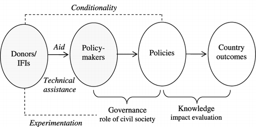
These three links, if assessed and monitored, can paint a clearer picture of the geospatial sector in Africa. This generic framework linking foreign aid, the policy process, and country outcomes is applicable to the geospatial sector given the aforementioned dominance of aid to geospatial activity in Africa. Each link of the framework merits its own empirical examination. A few researchers have begun to look at the governance link between African geospatial policy-makers and policy. Geospatial policy-making appears to be a process of importing and editing foreign policies and not a deliberative process capable of producing appropriate domestic policies (Georgiadou and Homburg Citation2008). In recent years, in light of perceived policy failures, donors and African civil society have begun to experiment () to potentially improve the capacity of civil society with the aid of mobile phones and web mapping to participate in policy-making and to directly demand the delivery of public services from their governments (Georgiadou et al. Citation2011). Researchers also have started questioning specific geospatial policies in relation to outcomes (Bassole et al. Citation2001, Kalande and Ondulo Citation2006), though rigorous or systematic evaluation of impacts of geospatial policies is lacking. No theoretically and empirically grounded study yet exists on the link between donors and geospatial policy-makers, the first two gray bubbles shown in and hence the focus of this study.
To examine the donors-policy-makers link in detail, we draw upon a seminal political science heuristic developed by Hood (1983) in The Tools of Government. Hood's classification of policy tools distinguishes types of interventions that are analytically and empirically separable, and thus is useful for comparison and analysis. Hood identifies four basic resources that any government has at its disposal to achieve its policy goals within its own society: organization, authority, treasure, and nodality (). Each resource enables a government to devise distinct tools to detect or effect change, thus making policies operational. With organization, a government relies upon civil servants (e.g. in the army, police, executive agencies etc) to coordinate social groups and deliver services. With authority, a government defines rules in a legal or official sense to which subjects must comply. With treasure, a government influences policy through the direct purchase of goods and services, provision of incentives, or instituting user charges. With nodality, a government draws upon its central position to collect and distribute information (e.g. national census, national development indicators).
Table 1. Resources of donors to achieve policy goals (adapted from Hood Citation1983).
Although Hood conceived of the tools of government as a way to study how a national government achieves its policy goals within a country, the toolkit is equally useful for studying how foreign agencies (such as donors) achieve their policy goals in another country when they provide aid to that country's government. Foreign aid allows African Governments to abdicate their responsibility to finance public goods, and donors end up substituting government in development planning. As Moyo (Citation2009a) described, ‘In Africa, public goods such as education, healthcare, infrastructure and yes, even security, are provided by donors. That is completely unacceptable.’ She reported a fellow African asking:
[W]hy do we even bother going to stand in the hot sun to vote for these leaders? We should actually be voting between CIDA and USAID, because ultimately they are the ones who are providing us with the public goods. (Moyo 2009a, p. 18)
2.3. New aid architecture
The external injection of foreign aid into national affairs has been severely criticized (Easterly Citation2006, Moyo Citation2009b). From 2005 up to now, stakeholders across the development sector have argued for significant changes to aid architecture. ‘New aid’ practices have been devised to replace ‘old aid,’ with a refreshed pledge to strengthen African Governments (OECD Citation2005). ‘New aid’ refers to commitments and instruments designed in accordance with the 2005 Paris Declaration on Aid Effectiveness, endorsed by over 100 donors and partner countries (African Development Bank 2005). The Paris Declaration is an international framework sponsored by Organization for Economic Cooperation and Development's Development Assistance Committee (OECD/DAC) that focuses on the quality of aid. It is yet another step in a history of efforts to improve the delivery and use of foreign aid. Like World Bank/IMF-led Poverty Reduction Strategy Papers in the 1990s, the Paris Declaration of 2005 promises increased ownership and better coordination. The Paris Declaration can be viewed as a counterpart to agreements that focus on UN-led commitments to development goals (e.g. Millennium Development Goals) and to UN/G8-led commitments on development finance (e.g. Monterrey Consensus, Doha Declaration on Financing for Development).
Donors and policy-makers in developing countries in partnership agreed to push for change in key areas relevant to this paper. For instance, policy-makers are meant to identify development goals and formulate a national development strategy. Ownership of a national development strategy should include systematic, broad-based stakeholder participation, including civil society, the private sector, and local governments. Donors should align aid to the national development strategy, rather than impose their own priorities. Donors should rely on partner countries' own mechanisms for implementing projects, rather than putting parallel systems in place. Donors and policy-makers jointly should manage for results, which includes establishing results-oriented reporting and assessment frameworks that monitor progress against key dimensions of the national development strategy and that improve evidence-based decision-making. National capacity development is the responsibility of partner countries, with donors playing a support role. Donors should strive to reduce duplication of efforts and harmonize their activities to make them as cost–effective as possible. Prior to the Paris Declaration, the onus for change repeatedly was placed on the recipient. Now, donors are called upon to change practices, as well.
Using Hood's heuristic, and in light of the ‘old aid’ and ‘new aid’ eras, we can compare how donors use organization, authority, treasure, and nodality and how donor tools have changed over time. In the geospatial sector, donors use ‘organization’ in the form of expert human capacity to influence policy-makers in a beneficiary country. Although donors lack direct legal ‘authority’ to define rules of behavior within beneficiary countries, they can make contracts conditional upon the recipients' behavioral change. With ‘treasure,’ donors steer policy change by providing financial incentives to development sectors or initiatives which they deem worthy of development in the beneficiary country. With ‘nodality,’ donors draw upon their strategic position to collect and dispense information (). These four resources (and combinations thereof) form the basis of the toolkit available to donors when seeking policy solutions in beneficiary countries. The resources can be seen as involving an increasing level of constraint. Roughly, the level of constraint inflicted on the recipient rises as we move from nodality, to treasure, to authority, and finally to organization-based tools (Hood Citation1983).
3. The changing aid game in Africa
Data for this study were collected through interviews, participant observation, analysis of documents, and review of literature. Both semi-structured and conversational interviews were conducted with aid agency officers, geospatial policy-makers, project implementers, and international consultants, covering the dynamics of foreign aid, and geospatial policy development. In addition, questions were posed and answered through electronic mail. The lead author participated in 15 Africa-wide conferences and 5 regional workshops focusing on geospatial policy and cross-agency coordination between 2001 and 2010; she organized and/or led 12 national workshops which addressed one or more of the following aspects: geospatial data discovery and visualization, geospatial data policy, cross-agency data sharing, and data standards. The lead author has extensive prior familiarity with the geospatial sector in Africa, including knowledge of aid practices through her employment as a contactor in aid-supported projects for over 15 years. Secondary data sources included aid agency reports, project documents, scholarly papers, conference proceedings, and internal documents such as feasibility studies. Most of the sources are publicly available, though a few documents are not. In addition, the lead author regularly followed the continuous stream of communication on aid project planning and evaluation at listservs and blogs. We group the data according to the resource (organization, authority, treasure, nodality) the donors used and identify the specific tools donors deployed in the eras of ‘old aid’ (prior to 2005) and ‘new aid’ (after 2005).
3.1. Organization
Donors use the ‘organization’ resource when providing technical assistance, either via their own consultants or via local contractors. ‘Old aid’ relied heavily upon technical assistance by ‘fly-in, fly-out’ consultants, rather than by local expertise. As a result, although many remote sensing projects have been conducted, many of the projects were contracted out to foreign consultants and local expertise in the use of GIS/RS technologies remained low (Adegoke Citation2003). Across sub-Saharan Africa, institutions of higher formal learning (polytechnics and universities) were generally by-passed in the development of capacity for the management of environmental information (Nkambwe Citation2002). Even today, many projects applying satellite data to African problems still do not include Africans working directly with the satellite data, but instead rely upon external partners (Wood and Weigel Citation2009). Further, technical assistance is problematic because it legitimizes the expertise of foreign contractors over local expertise. Recipients often accept norms of foreign experts without questioning or challenging them, because these norms are seen as the standardized or ‘correct’ way to do development work (Wallace et al. Citation2006). Thus, consultants have a significant influence over how a project is implemented – the practices, the software used, the standards applied (Skok and Legge Citation2002). Often, contractors or consultants copy procedures from their country of origin with the assumption that what worked in the North, should serve as best practice in the South. Choices regarding open-source versus proprietary approaches (see Jackson and Schell Citation2008) may be decided upon by contractors, rather than through a deliberative process of consultation with local recipients, leaving the direction of a project heavily dependent on whoever is given the project reigns. As an example, in Kenya, Japanese consultants had a major role in steering framework data development and defining geospatial standardization profiles, procedures, and practices; this work largely was based on the consultants' experience and methods acquired during standardization activities in Japan (Japan International Cooperation Agency (JICA) and Survey of Kenya (SOK) Citation2008).
‘New aid’ has retained technical assistance as a principal instrument, but a shift in the type of technical assistance provided is taking place. In recent years, we see an increase in aid agency support to curriculum development and the development of human capacity at African universities, e.g. UK's Developing Partnerships in Higher Education, Africa–U.S. Higher Education Initiative, China's new international partnership plan to assist 20 of its elite universities to foster partnerships with 20 African universities (MacGregor Citation2009). African universities can be viewed as ‘islands of stability’ for cooperation because they offer a means for sustaining analytical efforts beyond the limited time frames of project funding, and they educate the next generation of scientists, engineers, and public policy leaders (U.S. Department of State Citation2008, p. 8). The project Development of a Geographic Information Sciences based Education and Research Program at the National University of Rwanda, funded by The Netherlands Organization for International Cooperation in Higher Education is an example of technical assistance under ‘new aid.’ It is designed to build a multi-disciplinary team of local specialists at the University who will have the knowledge and skills to develop and conduct high quality training and research, as well as offer professional services. A 2007 survey of research collaboration with African universities documented the rise in North–South research linkages (Harle Citation2007). However, the increase in linkages is not being matched by increased financial support for research by African institutions (Harle Citation2007).
3.2. Authority
Donors use ‘authority’ when they inscribe conditionality in project contracts. In ‘old aid,’ conditionality was a dominant feature. It referred to projects being made conditional upon the recipient's adoption of universal ‘good practices.’ Geospatial technologies were introduced in Africa mainly by means of conditionality. GIS adoption was a condition for obtaining loans for development from donors, tied to the financing of environmental development programs in the subcontinent in the 1990s (Kyem Citation1999). Aid agencies often by-passed recipient governments all together with respect to technology adoption, as highlighted in a South Africa case studied by Noongo (Citation2007):
The development of GIS at the CBS [Central Bureau of Statistics] started in 1999 with the preparations of the 2001 census. During the early preparation stage, SIDA (one of the main funding bodies of the census) commissioned GeoSpace (a South African based GIS consulting company) to investigate the feasibility of using GIS during the 2001 census.[…] All agreements and lines of communications in this feasibility study were directly between GeoSpace and SIDA, while the CBS did not play any role or got involved in anyway. As a matter of fact, the CBS was not even aware that there was a feasibility study being carried out. (p. 139)
In ‘new aid,’ geospatial technologies are sufficiently mainstreamed that they no longer need to be conditionally imposed. But, inscription of control practices into contracts continues, with interesting twists. While financial accountability and transparency still are required, donors are putting greater emphasis on performance accountability and managing for results. This includes ex-ante identification of output indicators and performance monitoring over the course of projects against the defined indicators. Some aid agencies also have begun to inscribe explicit data management practices into contracts and grants to ensure that grantees follow pre-set data collection standards, create metadata, archive data, and establish data access conditions, and unambiguously document them. For instance, because USAID is required to make non-proprietary geospatial data available to the public, USAID partners that create geospatial data with funding from USAID (Citation2010):
will be required to electronically submit these geospatial data layers to USAID within 30 days of the end of each fiscal year during the life of their Awards […] To maximize USAID's investment and ensure effective re-use, geospatial data created with USAID funds must be compliant with ISO 19115 Geospatial Metadata Standards. (p. 1)
Similarly, the Gordon and Betty Moore Foundation (GBMF Citation2008) has established a data-sharing policy that specifies that:
[a]ll data used in or developed in whole or in part by GBMF funded projects (and that can be shared in a manner consistent with applicable laws) will be made widely available and freely shared as soon as possible. (p. 1)
[…] As part of the GBMF grant development process, potential grantees are required to develop a Data Management and Sharing Plan (the Plan) with their GBMF program officer. (p. 2)
If [recipients] don't deliver what was mutually agreed upon, then the trust is gone, and it's very unlikely that they will get another grant. We cannot stop payment [if data are not managed according to agreement], but the organization cannot expect to get funding again. (ibid)
3.3. Treasure
Donors use ‘treasure’ to privilege a certain sector by deeming it worthier of financial incentives than another. As Volvo Research and Educational Foundations stated in a report, under the heading Influencing development, ‘We have an opportunity to influence development by steering calls for proposals toward the areas that we have identified as of critical importance for future development (Volvo Research and Educational Foundations Citation2008, pp. 6–7).’
‘Old aid’ is characterized by the financing of single-agency, fragmented, thematic projects, aligned to donor priorities. Many projects reflect ‘an excessive data focus implying a preoccupation with aspects of data standards, interoperability, metadata, etc., which marginalizes the influence of the social, political, historical conditions within which the design and use of the end products takes place (Georgiadou et al. Citation2005, p. 114).’ Donors have a history of focusing on technology and data acquisition to accomplish a pilot or initial application, with insufficient consideration of documenting the work performed and establishing how the system will be maintained once the project is completed. Also, end-users typically are not central to the design process, so there is a lack of clarity of how end users will embed the results into their decision-making. Noongo (Citation2007) came to this conclusion when she reflected on GIS projects in Namibia:
Although it seemed easy to implement computer information systems, I realized that we lack the full understanding of their nature and their potential. In addition, there tends to be confusion about how processes like decision-making might be improved by a computer technology like GIS. When information systems do fail, more often than not, our immediate, almost instinctive reaction is to look for technical explanations. We ask what went wrong with the software, is the network infrastructure or protocols inadequate. It shows how we regard information systems as technical projects, thus looking for technical reasons for failure. We appear to create one technical innovation after another as we move farther away from questions regarding implementation aspects and implications of these innovations. (p. 11)
In the ‘new aid’ era, donors support cross-agency efforts that are more structural in nature, focusing specifically on coordination and data sharing across organizations and sectors (). These cross-agency initiatives come with the promise of helping to reduce duplication, increase efficiency, and improve decision-making. Similarities in these projects in different countries reflect a degree of convergence and learning within aid agencies with respect to the need for greater focus on institutional arrangements and creating an information foundation to support broader societal goals. Also, there is more dialog and opportunity for consultation on national geospatial strategies, as evidenced by conferences organized by project implementers and supported by donors. Projects that support cross-agency coordination and data sharing increasingly stem from a country's own specialists, though the line as to whether these projects are country-defined, selected and owned or donor-advanced is difficult to pinpoint.
Table 2. Examples of aid-supported cross-agency geospatial coordination projects.
Although aid practice shows signs of more consultation for project selection and design, the alignment of projects to country priorities still can be problematic. For instance, the European Commission, at the request of African nations, has been implementing a Joint Africa-EU Strategy, agreed upon in Lisbon in 2007, under which African institutions would drive rather than be steered by the developed European states (Council of the European Union Citation2007). Several of the eight partnerships in the Joint Africa-EU Strategy involve geospatial data – in many cases directly – in their operational plans or proposed projects. Yet, the European Commission (Citation2009, p. 5) reported a lack of participation on the part of the African nations and institutions in implementing the Joint Africa-EU Strategy, at the operational level, a divergence from the modus operandi endorsed in the Strategy.
3.4. Nodality
Donors started using the ‘nodality’ resource in the ‘new aid’ era for the first time in the form of the catchword ‘donor coordination’: a strategic position from which to collect and dispense information in the beneficiary country and amongst other donors. Donor coordination under the ‘new aid’ architecture has influenced the ways in which aid agencies see themselves and the ways in which they work. Donors are becoming more reflective, questioning their approaches, and grappling with how to improve effectiveness. They are developing ‘best practice’ documents and protocols for data management within aid-supported projects (e.g. Wehrmann and Glavina Citation2009, infoDev Citation2010, Wehrmann Citation2011). They are using their nodal position to collect and distribute ‘best practice’ and innovative examples of collaborative approaches. This nodality-based tool usually is exercised in an advisory rather than a prescriptive manner. For instance, The World Bank explains:
Our client countries are starting to come to us for advice on how to organize their own SDI systems, to manage the growing pool of GIS resources better. […] On the matter of supporting SDI development in client countries, there is always the risk that we influence more than we should. We are exploring how to offer an open set of options, instead of passing a judgment. (personal communication with World Bank representative, 25 April 2009)
Another nodality-based tool is manifest in the mapping of aid flows to improve the transparency of aid and access to aid information to recipient organizations, researchers, development practitioners, and beneficiaries in developing countries. An aid transparency standard has been developed so that donors can publish their content to the web (International Aid Transparency Initiative [IATI] Citation2011). In the past, aid agencies were subject neither to intense competitive pressure nor to scrutiny from analysts and rating agencies. Now, aid agencies are embracing competitive pressures by providing better information about where aid is being spent and publishing independent evaluations of projects. This competitive environment should improve the governance of aid agencies and the quality of the aid they deliver (Harford and Klein Citation2005). However, progress is slow, because the intended users of this data – CSOs, parliaments, researchers – have yet to apply this data to question donors' actions and effectiveness (Mulley Citation2011). Donors are gathering ‘evidence’ and using geospatial technologies to have a more holistic view of the spatial dimension of aid to support future allocation of resources. For instance, the Sahel and West Africa Club/OECD (SWAC) mapped aid flows to local communities within Mali to analyze the overall spatial coherence of aid from a national, spatial perspective (SWAC Citation2009). JICA took a similar approach, new to the agency, in the mapping of medical facilities in Zambia and incorporating the overall spatial dimensions of aid in the health sector into future planning (Ministry of Foreign Affairs of Japan Citation2007, p. 23). Similarly, the World Bank mapped its active projects in Kenya to get a better understanding of where its funding is allocated (AidData.org Citation2010).
A third nodality-based tool is exercised in the use of language. Language can be used to shape action and ways of thinking – serving as persuasive doctrine or myth (Homburg and Georgiadou Citation2009). As Hood (1983 p. 140) pointed out ‘there is no such thing as an intrinsically “innocent” instrument of government.’ Aid agencies have modulated their language from ‘technical assistance’ to ‘technical cooperation,’ insinuating a shift of emphasis from the transfer from a knowledge-rich North to a knowledge-poor South, to a more cooperative and dialogic North–South relationship (Wilson Citation2007). The language of cooperation with recipients affirms the new architecture of aid, which is meant to reduce donor interference in recipient country policy-making and improve local participation in planning processes and decision-making. Donors now refer to themselves as development partners, and commonly speak of ‘mutual responsibility,’ ‘partnerships,’ and ‘dialog.’ However, many discount this language turn as just rhetoric, and remark that inherent power imbalances between donors and aid-dependent countries undercut the Paris Declaration processes (Chandy and Kharas Citation2011). The words ‘assistance’ and ‘cooperation’ enable donors to appear as ‘technocratically neutral’ and ‘imply a non-existent parity of power between the technical helpers and the helped (Cooke Citation2004, p. 607).’ The World Bank masks the coercive character of its policy transfer using the apolitical-sounding language of ‘diffusion’ and ‘knowledge sharing,’ alongside the technical or neutral terms of ‘best practice’ and ‘benchmarking’ in its documents (Stone Citation2001).
4. Appraisal on the evolution in the donors' policy-makers link
This section reflects on the evolution of tools used by donors to ‘govern’ policy-makers in the geospatial sector in Africa (). We analyze this development in terms of changes in the constraints upon recipients, as a result of using different tools in the two aid regimes: old and new. Following the imperative of ‘new aid,’ to minimize constraint, donors may put greater emphasis on treasure and nodality.
Table 3. Evolution of donors' tools: from old aid to new aid.
Nodality does feature prominently in the ‘new aid’ architecture and is a welcome sign of donor effort to decrease constraint on recipients in the geospatial sector. The emergence of nodality tools, for instance assembling ‘best practices’ to shape knowledge and attitudes, and conducting portfolio mapping to increase donor transparency and better targeting of aid, is not surprising given the rapid development of information technology which fosters nodality (Hood and Margetts Citation2007). Still, power imbalances between donors and recipients prevail, causing critics of aid to claim that the most prevalent nodality tool of donors has been their rhetoric.
‘Treasure’ is undergoing changes in the way it is used. The funding of cross-agency geospatial coordination programs can be seen as a positive step to correct for two decades of aid that resulted in substantial fragmentation of the geospatial sector. However, the degree of country ownership, as opposed to donor push for such projects, is questionable. While there may be greater consultation between donors and policy-makers surrounding projects, the impetus of the project may still stem from donors. The act of supplying funds for such activity still is value-laden, particularly if the effort has been pre-selected and advanced by a donor. Foreign aid alters incentives for governments. If countries do not have to fund the work themselves, they do not really adopt the innovation (van Teeffelen Citation2000). Woldai (Citation2002) echoed this sentiment based on his 20 years of experience working in Africa: governments accept new initiatives without analyzing the consequences. Furthermore, the introduction of a coordinating body or committee is a form of manipulation of the local context. This happens when an organization, through its access to funding, assumes a position of authority and attempts to regulate membership and action of other organizations. In effect, donor projects may be tampering with domestic organizational boundaries by over-using the treasure tool. Donors confer power and legitimacy on those organizations chosen to receive funding. A perceived unequal distribution of resources can define and position actors vis-a-vis each other. Similarly, the choices that aid agencies make in terms of channeling funds to government organizations or civil society – such as projects that are designed to empower CSOs to influence policy – reflects a political ideology that can have important, unanticipated consequences for the recipients (Wedel Citation2001).
Although authority tools come with higher constraints, authority is being used in the ‘new aid’ era to achieve a positive, community outcome. The new conditionality underpinning aid contracts could prove effective in improving data access and standards. Performance accountability, while principally still an ex-ante control measure, holds promise for greater accountability for results and could be used to identify recipients for future aid allocation. However, conditionality in any guise is often viewed as dysfunctional, because it undermines the domestic political process by imposing policy from afar. The inscription of financial mechanisms also have become more demanding in recent years (World Bank Citation2009, p. 21), and while these mechanisms may increase accountability, they typically are influenced by public management reforms originating in developed countries and transferred to the developing world.
Finally, organization is undergoing changes in the way it is being used. In the ‘old aid’ era, when technical assistance reigned supreme, donors regularly required that experts be hired from the donor country (Easterly Citation2006). In effect, aid recipients were handing back aid to consultants from the donor country. Furthermore, the funding of foreign consultants undermined the development of local GIS firms, which invariably were passed over in favor of international ones. In the ‘new aid’ era, donors are beginning to strengthen and recruit human capacity from domestic universities. This is a positive development, though the bulk of technical assistance continues under ‘old aid’ practices. Even for the university-orientated projects, it is unclear just how much the projects are staffed by existing local experts in Africa, or whether the projects merely have shifted from foreign, private sector consultants to foreign, academic ones. Also, a potential imbalance remains in the allocation of resources, with the bulk of funding going to non-African institutions. In sum, the geospatial sector still continues to rely on technical assistance, a tool of the highest constraint, despite the shift to strengthening African academia and human capacity.
5. Conclusion and further research
This paper is the first ever ‘broad brush stroke’ of the donor-policy-makers dynamics in an emerging Digital Earth. We used two lenses. With the first lens (Bourguignon and Sundberg Citation2007) we scoped the particular area of focus within the aid effectiveness chain. It pointed us to a particular concern to address, the link between donors and policy-makers. By inserting the second lens (Hood Citation1983), we conceptualized and grounded empirically this particular link. Using wide-ranging data from primary and secondary sources, we discussed in a structured way how donors influence the actions of policy-makers in recipient countries by changing over time the tools they use which are based on donor organization, authority, treasure, and nodality. The main conclusion is that ways in which donors/IFIs relate to African policy-makers are a constitutive part of Digital Earth in Africa and warrant extensive consideration.
The vision of a Digital Earth in Africa will be more achievable if the ‘new aid’ architecture is applied more rigorously than currently is the case. Presently, the continuing reliance on high-constraint tools based on organization and authority contradicts the Paris Declaration principles of local ownership and participatory politics. However, the intention of this paper is not to advocate one tool over another. Rather, we would like to sharpen our ability to analyze the tools being used in practice and our awareness of how they are changing over time. We may be experiencing not a shift in donor practice per se, but an expansion of the tools used – leading to only ‘new-ish aid,’ instead of ‘new aid.’ What results is a ‘clumsy’ approach with donors combining elements of different policy paths. This clumsiness was found in other studies looking at geospatial coordination and external, funding bodies (Lance et al. Citation2009, Citation2011). Donors may use foreign consultants to maintain better control over outcomes, because new aid architecture puts heavy emphasis on ‘managing for results.’ Meanwhile, this contradicts the call for greater local ownership and understanding of local context. Similarly, inscription of open data access and archiving conditions in contracts and grants, has the potential to achieve broad community-wide benefits that otherwise would not be forthcoming, but this tool still is coercive.
The conceptual framework presented in this paper opens up a field of inquiry that could improve how donors craft their involvement in geospatial technology management and use in Africa. Pertinent questions still to be explored include: How do aspects of donor contracts (e.g. size, duration, performance monitoring, and renewal potential) shape the incentives for and responses of policy-makers? In Bourguignon and Sundberg's model (), the link between donors is represented by an arrow, but the relationship actually is shaped in both directions. Policy makers are not merely passive recipients; they can act as innovators, gatekeepers, and brokers. Armed with the list of promises in the Paris Declaration, they are better positioned to demand that donors improve aid practices. The nature of partnership between donors and policy-makers warrants further research; are partnerships being developed and maintained in a mutually serving and less power-asymmetric manner than in the past? What is the impact of new ‘inscription in grants’ on data standards and access, and does ‘portfolio mapping’ serve as a catalyst for critical assessment of donor investment in geospatial projects? How does donor-supported civil society engagement affect policy processes? Research also could be conducted comparing different aid agencies, including emerging, non-traditional donors such as China and Brazil, since there is considerable variation which we were not able to cover in this analysis (Angemi Citation2008). Most importantly, further work is needed along the full set of linkages to fully clarify the contribution of aid to geospatial outcomes: ‘policy-makers – policies,’ ‘political systems and the role of civil society,’ and ‘policies – country outcomes.’ This includes greater knowledge of the policy processes in different countries, the governance characteristics of countries, and the capacity of CSOs.
Research also should extend beyond donors, since other external actors, such as corporations, vendors, international organizations, professional associations, and advocacy groups, may play a part in influencing policy-makers. The GEO specifically envisions activities in its work plan to engage donors in earth observation capacity building priorities. Similarly, the recent eye on earth (EoE) effort has a proposed Special Initiative to create a geospatial community of practices within aid agencies. GEO, EoE, and the International Society for Digital Earth each aim to raise awareness amongst policy-makers on the utility of geospatial technologies, promote standards and open access policies, and transfer ‘best practice’ to national governments. GEO by design is more tightly coupled with political processes, but ultimately, policy adoption by member countries is voluntary, not obligatory. That said, if countries have a desire for international acceptance, they may conform to internationally endorsed practices.
References
- Abiodun, A.A., 2000. Development and utilization of remote sensing technology in Africa. PE&RS, 66 (6), 674–686.
- Adedeji, A., 1988. Remote sensing and African development programs. Photogrammetria, 43 (1), 17–24.
- Adegoke, J., 2003. Report of Project Evaluation Mission to the Department of Agricultural Engineering and Land Planning, Botswana College of Agriculture, Gaborone Botswana. UNESCO crosscutting project on the Application of Remote Sensing for Integrated Management of Ecosystems and Water Resources in Africa, 9–13 August.
- AidData.org, 8 August 2010 Mapping for results [online]. Available from: http://blog.aiddata.org/2010/08/mapping-for-results.html [Accessed 10 August 2011].
- Akbar Zaidi, S., 1999. NGO failure and the need to bring back the state. Journal of International Development, 11 (2), 259–271.
- Angemi, D., 2008. A primer on aid effectiveness: development partners or development parasites? Evidence from Uganda. Harvard Africa Policy Journal, 5, 5–19.
- Ayanlade, A., Orimoogunje, I.O.O. and Borisade, P.B., 2008. Geospatial data infrastructure for sustainable development in sub-Saharan countries. International Journal of Digital Earth, 1 (3), 247–258.
- Bassole, A., Brunner, J. and Tunstall, D., 2001. GIS: supporting environmental planning and management in West Africa. Washington, DC: World Resources Institute.
- Baud, I., et al., 2011. Developing participatory ‘spatial’ knowledge models in metropolitan governance networks for sustainable development: literature review. Chance2Sustain. Bonn: European Association of Development Research and Training Institutes.
- Bourguignon, F. and Sundberg, M., 2007. Aid effectiveness: opening the black box. American Economic Review, 97 (2), 316–321.
- Brautigam, D. and Botchwey, K., 1999. The institutional impacts of aid dependence on recipients in Africa. Bergen: Chr. Michelsen Institute, Working Paper 1.
- Chandy, L. and Kharas, H., 2011. Why can't we all just get along? The practical limits to international development cooperation. Journal of International Development, 23 (5), 739–751.
- Conitz, M.W., 2000. GIS applications in Africa. PE&RS, 66 (6), 672–673.
- Cooke, B., 2004. The managing of the (Third) World. Organization, 11 (5), 603–629.
- Council of the European Union, 9 December, 2007. The Africa-EU strategic partnership: a joint Africa-EU strategy [online]. Lisbon, 16344/07 (Presse 291). Available from: http://www.consilium.europa.eu/uedocs/cms_data/docs/pressdata/en/er/97496.pdf [Accessed 24 June 2012].
- Easterly, W., 2006. The white man's burden: why the west's efforts to aid the rest have done so much ill and so little good. New York: Penguin.
- Edwards, M. and Hulme, D., 1996. Too close for comfort? The impact of official aid on nongovernmental organizations. World Development, 24, 961–973.
- ESRI East Africa, 2009. ESRI market metrics and total sales. Nairobi: ESRI East Africa.
- Etounga-Manguelle, D., 2000. L.E. Harrison, and S.P. Huntington, eds. Culture matters: how values shape human practice, (pp. 67–78). New York: Basic Books. Does Africa need a cultural adjustment program?
- European Commission, 24 July 2009. Commission staff working document: implementation of the joint Africa-EU strategy and its first action plan (2008–2010): input into the mid-term progress-report [online]. Available from: http://register.consilium.europa.eu/pdf/en/09/st12/st12320.en09.pdf [Accessed 24 June 2012].
- Georgiadou, P.Y., et al., 2011. Sensors, empowerment and accountability: a digital earth view from East Africa. International Journal of Digital Earth, 4, 285–304.
- Georgiadou, Y. and Homburg, V., 2008. The argumentative structure of spatial data infrastructure initiatives in America and Africa. In: C. Avgerou, M.L. Smith, and P. van den Besselaar, eds. Social dimension of information and communication technology policy. Boston, MA: Springer. 31–44.
- Georgiadou, Y., Puri, S.K. and Sahay, S., 2005. Towards a potential research agenda to guide the implementation of spatial data infrastructures: a case study from India. International Journal of Geographical Information Science, 19 (10), 1113–1130.
- Georgiadou, Y., Rodriguez-Pabon, O. and Lance, K.T., 2006. Spatial data infrastructure (SDI) and E-governance: a quest for appropriate evaluation approaches. URISA Journal, 18 (2), 43–55.
- Gibson, C.C., et al., 2005. The Samaritan's dilemma. The political economy of development aid. Oxford: Oxford University Press.
- Gordon and Betty Moore Foundation (GBMF), 18 September 2008. Data sharing philosophy and plan [online]. Palo Alto CA. Available from: http://www.moore.org/docs/GBMF_Data%20Sharing%20Philosophy%20and%20Plan.pdf [Accessed 24 June 2012].
- Harford, T. and Klein, M., 2005. Aid effectiveness: can aid agencies be smarter than the invisible hand? Public Policy for the Private Sector, Note No. 292. June 1–4
- Hastings, D.A. and Clark, D.M., 1991. GIS in Africa: problems, challenges and opportunities for co-operation. International Journal of Geographical Information Systems, 5 (1), 29–39.
- Harle, J., 2007. Frameworks for Africa–UK Research Collaboration in the Social Sciences and Humanities: African University Perspectives. London: Association of Commonwealth Universities, Report to the British Academy.
- Homburg, V. and Georgiadou, P.Y., 2009. A tale of two trajectories: how spatial data infrastructures travel in time and space. The Information Society, 25 (5), 303–314.
- Hood, C., 1983. The tools of government. Basingstoke: Macmillan.
- Hood, C. and Margetts, H., 2007. The tools of government in the digital age. London: Palgrave.
- infoDev, 2010. GIS and SDI for development project [online]. The World Bank. Available from: http://www.infodev.org/en/Project.111.html [Accessed 10 August 2011].
- International Aid Transparency Initiative (IATI), 2011. IATI standard [online]. Available from: http://dev.iatistandard.org/ [Accessed 24 June 2012].
- Jackson, M. and Schell, D., 2008. SDI and the changing dynamics of the geospatial market. Proceedings of map middle east 2008 (Slide 31), 8–10 April, Dubai.
- Japan International Cooperation Agency (JICA) and Survey of Kenya (SOK), 2008 Project for strengthening survey of Kenya for GIS promotion in the Republic of Kenya: final report. Tokyo: Kokusai Kogyo Co., Ltd.
- Johnson, S., 2011. Land administration projects financed by development agencies [online]. Available from: http://www.landadmin.co.uk/Projects.htm [Accessed 10 August 2011].
- Kalande, W. and Ondulo, J.D., 2006. Geoinformation policy in East Africa. XXIII FIG congress, 8–13 OctoberMunich.
- Kyem, P.A.K., 1999. Examining the discourse about the transfer of GIS technology to traditionally non-Western societies. Social Science Computer Review, 17 (1), 69–73.
- Lance, K.T., 2003. Spatial data infrastructure in Africa: spotting the elephant behind the trees. GIS Development, 7 (7), 35–41.
- Lance, K.T., 2005. Tracking geospatial investments in Africa. Proceedings of the AfricaGIS conference 2005,31 October–4 NovemberEIS-AfricaPretoria
- Lance, K.T., 2010. Monitoring the earth observation sector in Africa: Generating statistics on employment, education, industry growth, and investment. 8th AARSE conference, 28 OctoberAddis Ababa
- Lance, K.T., Georgiadou, P.Y. and Bregt, A.K., 2009. Cross-agency coordination in the shadow of hierarchy: joining up government geospatial information systems. International Journal of Geographical Information Science, 23 (2), 249–269.
- Lance, K.T., Georgiadou, P.Y. and Bregt, A.K., 2011. Evaluation of the Dutch subsurface geoportal: what lies beneath? Computers, Environment and Urban Systems, 35 (2), 150–158.
- MacGregor, K., 2009. Collaboration key for African university revival [online]. University World News, July 12. Available from: http://www.universityworldnews.com/article.php?story=20090711095604781&query=African+higher+education [Accessed 24 June 2012].
- Makanga, P. and Smit, J., 2010. A review of the status of spatial data infrastructure implementation in Africa. South African Computer Journal, 45, 18–25.
- Meyer, C.A., 1992. A step back as donors shift institution building from the public to the “private” sector. World Development, 20 (8), 1115–1126.
- Ministry of Foreign Affairs of Japan, 2007. The country assistance evaluation of Zambia. Third-party evaluation 2006 [online]. Available from: http://www.mofa.go.jp/policy/oda/evaluation/FY2006/text-pdf/zambia.pdf [Accessed 24 June 2012].
- Mosse, D., 2004. Good policy is unimplementable? Reflections on the ethnography of aid policy and practice. Development and Change, 35 (4), 639–671.
- Moyo, D., 2009a. Transcript of Munk debate on foreign aid: foreign aid does more harm than good.Toronto,ONThe Aurea Foundation .
- Moyo, D., 2009b. Dead aid: why aid is not working and how there is a better way for Africa. New York: Farrar, Strauss, and Giroux.
- Mulley, S., 2011. Donor aid: new frontiers in transparency and accountability. London: Transparency and Accountability Initiative, Open Society Foundation.
- Neu, D. and Ocampo, E., 2007. Doing missionary work: The World Bank and the diffusion of financial practices. Critical Perspectives on Accounting, 18 (3), 363–389.
- Nkambwe, M., 2002. Models for capacity building in environmental information systems in sub-Saharan Africa: necessity for coordination. The International Archives of the Photogrammetry, Remote Sensing and Spatial Information Sciences, XXXIV (Part 6/W6), 13–16.
- Noongo, E.N., 2007. The implementation of geographic information systems in Namibia. Thesis (PhD). University of Joensuu, 240.
- Organization for Economic Cooperation and Development's Development Assistance Committee (OECD), 2005. Paris declaration on aid effectiveness: ownership, harmonization, alignment, results, and mutual accountability [online]. High Level Forum on Joint Progress toward Enhanced Aid Effectiveness. Available from: http://www.oecd.org/dataoecd/11/41/34428351.pdf [Accessed 24 June 2012].
- Sahel and West Africa Club/OECD (SWAC), 2009. Spatial coherence of aid in Mali. SWAC News, 4–5 hr. Available from: http://www.oecd.org/dataoecd/8/6/43014249.pdf [Accessed 10 August 2011].
- Schwabe, C. and Govender, S., 2009. Getting geoinformation and spatial data infrastructure (SDI) to work for Africa: the rationale behind AESI-ALIGN. Proceedings of GSDI 11 world conference, 15–19 JuneRotterdam
- Sewelo, S., 2006. Re: [Botswana GIS] so silent? [online]. Source: Botswana GIS Yahoo! group, June 1. 4:41 PM. Available from: http://tech.groups.yahoo.com/group/botswana_gis/message/369 [Accessed 3 August 2011].
- Skok, W. and Legge, M., 2002. Evaluating enterprise resource planning (ERP) systems using an interpretive approach. Knowledge and Process Management, 9 (2), 72–82.
- Stone, D., 2001. Learning lessons, policy transfer and the international diffusion of policy ideas. Coventry: Center for the Study of Globalization and Regionalization (CSGR), University of Warwick, Working Paper No. 69/01.
- United Nations Economic Commission for Africa, 2009. CODIST.1 report on member states activities since CODI V. Geo-information Sub-committee, 28 April–1 MayAddis Ababa
- United States Agency for International Development (USAID), 2010. Draft standard geospatial language to be inserted into USAID awards. GeoCenter internal document. Washington, DC: United States Agency for International Development, Office of Science and Technology.
- U.S. Department of State, 2008. Geospatial sciences for sustainable development in Africa. Global Dialogues on Emerging Science and Technology (GDEST) program. Washington, DC: U.S. Department of State.
- van Teeffelen, P.B.M., 2000. GIS and developing countries, the spatial diffusion of an innovation. Proceedings of GISDECO 2000, 2–3 NovemberLos Banos 10
- Volvo Research and Educational Foundations, 2008. Future urban transport [online]. Available from: http://www.vref.se/download/18.4472642a11a8dd88fe2800017339/VREF+Report+2008.pdf [Accessed 24 November 2011].
- Wallace, T., Bornstein, L., and J. Chapman, et al., 2006. The aid chain: coercion and commitment in development NGOs. Rugby: Intermediate Technology Publications.
- Wedel, J.R., 2001. Collision and collusion: the strange case of western aid to eastern Europe 1989–1998. New York: St. Martin's Press.
- Wehrmann, B., 2011. Land use planning manual. Concept, tools and applications. Eschborn: GIZ.
- Wehrmann, B. and Glavina, J., 2009. Geographic information systems (GIS) – the spatial dimension to development cooperation. Eschborn: GTZ.
- Wilson, G., 2007. Knowledge, innovation and re-inventing technical assistance for development. Progress in Development Studies, 7 (3), 183–199.
- Woldai, T., 2002. Geospatial data infrastructure: the problem of developing metadata for geoinformation in Africa. Proceedings of the 4th international conference of the African Association of remote sensing of the environment, 14–18 October 2002, Abuja.
- Wood, D. and Weigel, A., 2009. International collaboration on satellite-enabled projects in developing countries. Proceedings of space, propulsion and energy science international forum (SPESIF-2009). 16 March 2009 Huntsville, AL. American Institute of Physics (AIP) Conference Proceedings, 1103 (1) 414–422.
- World Bank, 2009. Improving municipal management for cities to succeed: an IEG special study. Washington, DC: Independent Evaluation Group (IEG)
Appendix 1: Definitions
The policy process is usually considered to include the following components: agenda setting, policy formulation, decision-making, implementation, monitoring and evaluation. Geospatial policies encompass those that enable increased access to, integration of, and use of government geospatial data and models about the virtual Earth in the public and private sectors. Geospatial policies also include those that determine government funding and efficiency in collecting, maintaining and distributing geospatial data.
Geospatial policy impacts include improved sharing of and access to digital data, models, and information about the virtual Earth in the public and private sectors; enhanced government efficiencies in collecting, maintaining and distributing geospatial data; an expanded role of Digital Earth in the fields of Earth science, including climate change, adaptation and health related issues, natural disasters, new energy sources, agricultural and food security, and urban planning.
Geospatial governance is the policy, organization, management, and delivery processes associated with geographically referenced models that represent the planet.
Geospatial policy-makers are not limited to parliamentarians (i.e. policy does not have to mean laws or directives to ministry or agency heads). An array of government agencies – heads of mapping agencies, environmental ministries, and statistical bureaus – determine whether a country has a framework which enables policies conducive to a ‘knowledge economy.’ Often policies at an institutional level determine data access and standards that shape data availability and reliability.
Geospatial sector spans organizations that acquire, integrate, manage, analyze, map, distribute, and use geographic, temporal, and spatial information and knowledge. The sector includes basic and applied research, technology development, education, and applications to address the planning, decision-making, and operational needs of people and organizations of all types.