
Abstract
Urban morphology and morphology change and their impacts on urban transportation have been studied extensively in planar urban space. The essential feature of urban space, however, is its three-dimensionality (3D), and few studies have been conducted from a 3D perspective, overly limiting the accuracy of studies on the relationships between urban morphology and transportation. The aim of this paper is to simulate the impacts of 3D urban morphologies on urban transportation under the Digital Earth framework. On the basis of the principle that population distribution and movement are largely confined by 3D urban morphologies, which affect transportation, high spatial resolution remote sensing imagery and a thematic vector data-set were used to extract urban morphology and transportation-related variables. With a combination of three research methods – factor analysis, spatial regression analysis and Euclidean allocation – we provide an effective method to construct a simulation model. The paper indicates three general results. First, building capacity in the urban space has the most significant impact on traffic condition. Second, obvious urban space otherness, reflecting both use density characteristics and functional characteristics of urban space, mostly results in heavier traffic flow pressure. Third, no single morphology density indicator or single urban structure indicator can reflect its contribution to the pressure of traffic flow directly, but a combination of these different indicators has the ability to do so.
1. Introduction
It is expected that by 2050 nearly 70% of the world's population will live in cities (United Nations Citation2007). This indicates that urban space will continue to grow rapidly, in particular in megacities of developing countries (Khisty Citation1993; Kenworthy Citation1995; Gakenheimer Citation1999). In the process of rapid urban expansion, urban transportation problems become more and more serious.
Many factors are claimed to increase transport-related urban problems in these growing megacities, for example, continuing population growth, skyrocketing car ownership and weak traffic management. However, the impact of urban morphologies on urban transportation is a fundamental factor. It is obvious that three-dimensional (3D) urban spaces are the main storage space of population and materials. Both people and material need moving in the urban. The urban transportation network is the exact linkage path of their movements. 3D urban spaces, composed mainly of buildings, can be reflected by 3D urban morphologies, which determine the transportation network's morphology and condition to a certain extent. Therefore, a more effective study could be introduced to reduce the negative traffic effects of urban morphology.
Recently, the impacts of urban morphology on transportation have received much attention. Cao et al. (Citation1998) took the Des Moines metropolitan area as a case study, demonstrating the relationships between urban population density, travel patterns, and residential and commercial distribution. They then recommended further strengthening of the relationship between land use and transportation in travel planning models. Transportation Research Board's Transit Cooperative Research Program Report 74 (Burchell et al. Citation2002) analyzed the impact of urban sprawl on resources, including land conversion and local road infrastructure costs, ending with a discussion of the benefits of sprawl and ways to reduce the negative effects. At the Canada Centre of Remote Sensing (Zhang and Guindon Citation2006; Guindon and Zhang Citation2007), a Landsat-based Canadian national urban land database was generated along with a set of urban sustainability indicators as value-added information to inform transportation energy policies. On the basis of census and survey data, the Transportation Analysis Simulation System was developed. It is an agent-based simulation system of simulating the second-by-second movements of all pedestrian and vehicles through a regional transportation network (Nagel and Rickert Citation2001; Cetin et al. Citation2002). Using data acquired by the 1991 Activity–Travel Survey in Boston, Zhang (Citation2005) analyzed the relationship between urban morphology and nonwork travel. He tested the role of spatial accessibility as a composite measure of urban morphology in explaining individuals’ nonwork activity participation, travel times, and travel frequencies. The results showed varying effects of modifying spatial accessibility on nonwork activity participation and travel among different activity categories. Bhatia (Citation2005) explored a number of spatial characteristics of existing urban development patterns in Erie County, New York. Through a cross-sectional analysis, these measures of urban morphology were used to test how sprawl affects municipal transportation costs. In addition, Li (Citation2006) discussed the relationships between urban morphology and morphology of transport network, traffic patterns, as well as traffic structure. Moreover, McMillan (Citation2007) examined the influence of objectively measured urban morphology on travel mode to school and also the magnitude of influence urban morphology and nonurban morphology factors have on children's travel behavior. In the last two years, the impacts of urban morphology on urban transportation and transportation-related energy consumption have become a research focus. One of the key points is to reveal the relationships between urban morphology and urban transportation. Using the Census Data of Ireland 2006 and the Place of Work – Census of Anonymised Records datasets, Carty and Ahern (Citation2010) intended to examine urban morphology factors in terms of their influence on a journey to work's energy consumption. To examine the hypothesis, the transport energy consumption of different urban morphologies was found, thus allowing the most sustainable urban morphologies in the Greater Dublin Area to be identified. Using the 2001 National Household Travel Survey data, Liu and Shen (Citation2011) empirically examined the effects of urban land use characteristics on household travel and transportation energy consumption in the Baltimore metropolitan area. The results of regression analysis showed that different built environment measures lead to substantially different findings regarding the importance of urban morphology in influencing travel behavior. Chen et al. (Citation2011) revealed the dynamic distribution of urban land use based on land use classification by using remote sensing images from 2005 to 2008. The urban land use patterns were then quantified using a set of landscape metrics, which further served as explanatory variables in the estimation. The panel data analysis was implemented to estimate the relationship between urban land use patterns and energy consumption.
In the process of urbanization, more and more urban demands need to be met, which definitely need more urban space. When the urban is short of or run out of land resources, the urban will begin to grow higher into vertical space instead of sprawling larger in planar space. 3D characteristics have become the main features of urban morphology. But recent studies still have the following limitations: (1) due to the difficulty of acquiring 3D urban data, current studies on urban problems are still limited to the planar dimension. There have been few studies of the relationship between 3D morphology and transportation. (2) Urban morphology and transportation have been studied extensively on the overall macro level or in the changing region of its boundary. But few studies have been on the building level (taking each building as the study unit) to study the relationship between 3D morphology and transportation. (3) Most of the transportation models have been constructed on the basis of population data or human behavior data as the main data to analyze the impacts on urban traffic conditions. Their accuracy, however, is highly affected by original data uncertainties caused by mobility of the population, which makes statistics of urban population distribution and investigation of human behavior extremely difficult.
Examining the case of Beijing, the aim of this paper is to reveal the relationship between 3D urban morphology and urban transportation through modeling and spatial simulations to solve the above problem. The study is based on the principle that population distribution and movement is largely confined by its living space (3D urban morphology). 3D urban morphologies will be quantified to minimum units (building and linkage road) by a set of 3D urban morphology indicators, which are further taken as the explanatory variables for traffic pressure. Spatial data analysis, factor analysis, spatial regression analysis, and Euclidean allocation will then be integrated to estimate the impacts of 3D urban morphology on traffic pressure and urban transportation. The study results could be used in the policy implications of urban growth management for developing sustainable transportation. This paper presents the study in five parts. After Section 1, Section 2 introduces the study area and the data sources. Section 3 presents the research process and methodology. Section 4 reports the results and accuracy analysis of the implementation of the Beijing Dongcheng District case. Finally, Section 5 concludes the discussion.
2. Study area and data sources
2.1. Study area
Beijing, the capital of China, was chosen as the study area () and Dongcheng District of Beijing as the validation area ().
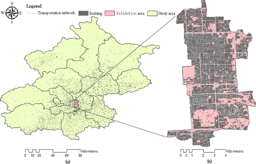
Beijing is the center for national politics, culture, transport, tourism, and international exchanges of China. The city center of Beijing is located at north latitude 39°56′, east longitude 116°20′. The whole city is made up of 14 districts and 2 counties, with an area of 16,410.54 km2 and a population of 19,612,368 as of 2010. The urban area of Beijing is about 1368.32 km2, and the built-up area reaches 1289.30 km2 (The largest city in China).
Dongcheng District is an urban district in Beijing, which covers the eastern half of Beijing's urban core. The southern boundary is the South Third Ring Road; the northern boundary is the North Third Ring Road; the western boundary is the central urban axis; and the eastern boundary is the East Second Ring Road. It is an area combining active politics, highly developed education, science and technology research, trading services, and cultural tourism with plentiful resources. As one of the central districts of the capital, Dongcheng District covers several important parts of Beijing. China's central government agencies, major political event venues, national research institutions, Chinese cultural relics (2 world cultural heritages and 26 national key cultural relic protection units), and the most important urban commercial district of China all belong to its jurisdiction. It is 41.48 km2 in area. The registered population is 0.919 million (Leading Group Office for Sixth Nationwide Population Census in Beijing Citation2011). With the exception of parks such as the Forbidden City and Temple of Heaven (the area with no building data shown in has no resident population), population per square kilometer in Dongcheng district is around 25,000, which is far greater than the average level of Beijing city by 10,306 people per square kilometer. The seriously high population density creates heavy pressure on urban traffic, which makes Dongcheng District an appropriate case region for studying the impact of urban morphology on urban transportation.
2.2. Data source and data processing
Two aerial images acquired in 2008 and 2009, and one high spatial resolution satellite remote sensing data (Quickbird) in 2007, were used in this research. The aerial remote sensing images were georeferenced to Universal Transverse Mercator projection, resampled to a pixel size of 0.3 m × 0.3 m, and the high spatial resolution satellite remote sensing images were georeferenced to the same projection and pixel size. The serial images from 2007 to 2009 were employed to extract spatial data of buildings and traffic.
The spatial information of buildings has multiple attributes, including building area, number of floors, center location, and use purposes. Image visual interpretation method was used to extract the building vector map in 2009, which offers the building area and center location information. Field survey method obtained the numbers of floors and use purposes information in 2009.
The spatial information of traffic includes attributes of road length, width, and road level as well as the traffic flow. Image visual interpretation method was used to extract the spatial distribution map of road in 2009, which offers the road length, width, and road level attributes by using the spatial analysis.
The traffic flow was composed by vehicles and pedestrians. Image visual interpretation method was used to extract the contour of the vehicles and human head. Finally, the geometric center point was calculated using ARCGIS software and creates the traffic flow point coverage. The traffic flow in 2007, 2008, and 2009 were interpreted as the basic map to calculate the traffic pressure indicator.
All these spatial data are in vector format with accurate location and topology relationships at a scale of 1:2000.
3. Methods
3.1. Basic principles and research process
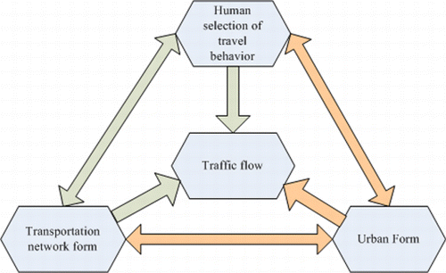
Urban transportation is a network system. Generally, in a network system, the flow of material and information is always being affected by three factors of the network: the property and size of the storage body, the form and resistance of the path, and the property of the flow material (Alexander and Sadiku Citation2007). For example, the circuit network, the water supply and drainage network, as well as the communication network all follow this law.
This law is also present in urban transportation networks according to a large number of observed data and information. Three factors affecting traffic flow in the urban transportation network involve the function and morphology of the urban space, the type and morphology of the transportation network, and people's trip willingness and trip carrier () (Groeger and Rothengatter Citation1998; Jiang and Liu Citation2009; Qin et al. Citation2006). People's trip destination, trip carrier, and path selection are always determined by which or where or how far the destination space is, so the two factors, people's travel behavior and transportation network, are finally driven by the third factor – the function and morphology of the urban space. Thus, the manner of people flow and material flow in the city is finally affected by their living space (3D urban morphology and its inner function) to a great extent. This shows that the methodology used in this paper, simulating traffic condition by studying 3D urban morphology, is reliable.
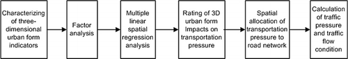
Based on the above principle, the numerical simulation and visualization of the impacts of 3D urban morphology on road traffic conditions were illustrated, taking city buildings and roads as the smallest unit, by using a high spatial resolution data-set of Beijing obtained by Earth observation technology. The research process was as follows. Firstly, a series of 3D urban morphology indicators were selected preliminarily as factors affecting traffic pressure. In observation sample regions (a set of typical blocks), the values of their 3D urban morphology indicators were calculated on the basis of large-scale building vector data of Beijing. And then, factor analysis was applied to eliminate the multicollinearity between these factors in order to elect the integrated 3D urban morphology indicators as final factors affecting the traffic pressure. The traffic pressure level of each road in the sample region was determined by real vehicles and human flow conditions on the road. Visual interpretation method was used to extract normally real vehicles and human flow conditions from multi-temporal high spatial resolution remote sensing images received in different times of the day. The values of 3D urban morphology indicators were subjected to spatial multiple linear regression analysis as independent variables and traffic pressure level as the dependent variable. Then, the independent variable coefficients in the multiple regression equation were calculated to construct the numerical simulation model of the 3D urban morphology's impacts on road traffic pressure. By using this model, the rating of the impacts was calculated and then allocated to each building according to the capacity proportion of each building among all the buildings in the region. Next, the traffic pressure carried by each building (the source of pressure) was allocated to the target (the road network) following the Euclidean allocation method in order to get the traffic pressure rating of the urban road network. Finally, we divided the traffic pressure rating of the urban road network by road width in order to determine the traffic condition rating of each road. depicts the research process.
3.2. Characterizing the 3D urban morphology
Buildings are the main component of the 3D urban morphology, so urban morphology indicators are constructed at the scale of building groups in this study. In 3D urban space, the height and volume of buildings and their spatial distributions represent the main features of the 3D urban morphology. Meanwhile, varieties of buildings with different height or volume located together under multiple combinations of ways in urban space also form different 3D urban morphologies (Ge Citation2009). Thus 3D urban morphology indicators were selected primarily on consideration of building distribution features in 3D urban space, including the density indicator, otherness indicator, composition indicator, and structure indicator. They all have linear relationships with traffic pressure and are defined as follows:
3.2.1. Density indicator
•Building distribution density (Density1) is defined as the sum of buildings divided by the area of the buildings' distribution region.
Building area density (Density2) is defined as the sum of individual building areas divided by the area of the buildings’ distribution region.
Height distribution density (Density3) is defined as the sum of each building's height divided by the area of the buildings’ distribution region.
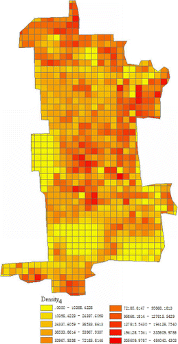
Capacity distribution density (Density4) is defined as the sum of each building's capacity divided by the area of the building's distribution region.
3.2.2. Otherness indicator
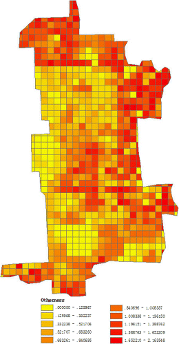
Building otherness is defined as the standard deviation in the height of building groups divided by mean building height.
3.2.3. Composition indicator
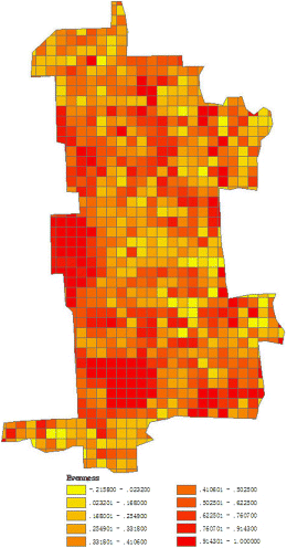
Evenness is defined as
3.2.4. Structure indicator
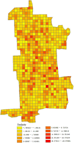
Moran's I is used as an indicator to measure similarity.
3D urban morphology indicators were calculated according to the formulas above in a set of sample regions selected from the study region as a real data-set. Together with the rating of the urban traffic pressure, they were then subjected to spatial multiple linear regression analysis, taking the value of 3D urban morphology indicators as independent variables and transportation pressure level as the dependent variable, thus constructing the numerical simulation model of the impacts of 3D urban morphology on road traffic pressure.
3.3. Construction of independent variables from factor analysis
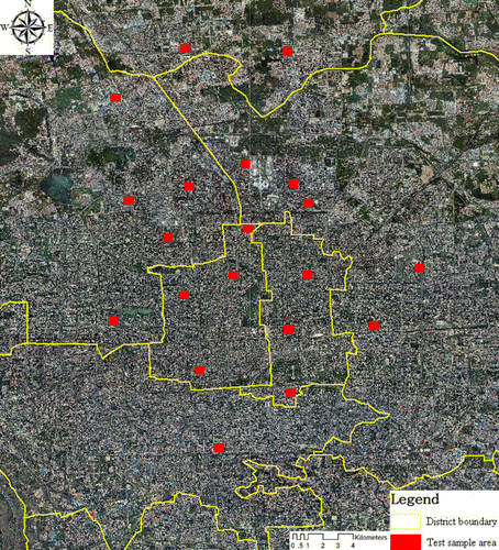
The independent variables were primarily calculated upon 20 training samples chosen from the study area – Beijing city – with the same area and shape (). Twenty training samples were selected from a set of randomly generated samples according to the principle that they should distribute evenly and represent varieties of urban functions in order to ensure the universality of the spatial distribution and function of the sample. The sample size was determined by majority area.
The 3D urban morphology indicators of the samples were computed on the basis of formulas 1 to 7, including Density1, Density2, Density3, Density4, Otherness, Evenness, and Similarity. The number of vehicles and estimated human flow density per unit length on the roads of the samples were interpreted from aerial remote sensing images and high spatial resolution satellite images. The traffic pressure has tidal changes in one day because different urban spaces have their unique function so that human's daily life is active in different urban spaces according to the time of the day. In order to ignore the daily changes of the traffic pressure, normal condition of the traffic pressure is used in this study. The average value of the traffic condition integrated from three images in different daily times is calculated to present the normal condition of the traffic pressure. According to this transportation information, the traffic pressure (y) level of each road in the sample region was scored with a minimum value of 0 and maximum value of 10 by using the following equation:
The results of the traffic pressure (y) levels are shown in .
Table 1. Urban form variables and traffic pressure values in the sample area.
The interrelationships between the seven urban morphology indicators were analyzed using factor analysis. Factor analysis uncovers the structure of the variability in data and therefore detects multicollinearity. The mean, standard deviation and sample number of the seven factors are given in .
Table 2. Descriptive statistics of the seven selected variables.
shows the correlation matrix of the seven variables.
Table 3. Correlation matrix of the seven variables.
Principal component analysis was used to extract factors. The seven variables were rotated by varimax with Kaiser normalization, therefore simplifying the factor loading matrix as shown in .
Table 4. Rotated factor (component) matrix.
Let X1, X2, X3, X4, X5, X6, and X7 represent Density1, Density2, Density3, Density4, Otherness, Evenness, and Similarity, respectively. The factor model is
As shown in the factor model, factor one FAC1 indicates density features of urban space primarily, and factor two FAC2 reflects structure features and composition features of the urban space. The scores of FAC1 and FAC2 in the sample region are listed in .
Table 5. Factor score of each sample.
3.4. 3D analysis of the impacts of urban morphology on urban traffic pressure from multiple linear regression analysis
The scores of FAC1 and FAC2 were subjected to multiple linear regression analyses as independent variables and traffic pressure level of the sample region (y) as the dependent variable. Then, the regression coefficients of the independent variables in the multiple linear regression equation were calculated as listed in .
Table 6. Coefficients of regression factors as independent variables.
Let x1 and x2 represent FAC1 and FAC2, respectively. The equation expressing the impacts of 3D urban morphology on urban traffic pressure is
As mentioned above, FAC1 (x1) primarily indicates the density features of urban space, and factor two FAC2 (x2) reflects urban space structure and composition features, which reveals that urban space with remarkable density features such as a large number of buildings, with large area, as well as with large height density, does not contribute much to traffic pressure. Most of these spaces with high land occupation density in the study area are low-rise buildings with small building gaps, fewer floors, and small capacity, and also have a simple function, so they create relatively smaller traffic flow nearby, and also exert less pressure on transportation. On the other hand, the urban spaces with remarkable spatial structure or composition features, especially capacity density and otherness, contribute more to traffic pressure. The buildings with high capacity always have plenty of functions and also accommodate more people. Meanwhile, most of the urban spaces with obvious building otherness have more high buildings, complex functions, and high capacity. Such urban spaces mostly have heavy traffic flow and also create large pressure on transportation.
3.5. Spatial allocation of traffic pressure to the urban road network and traffic condition calculation
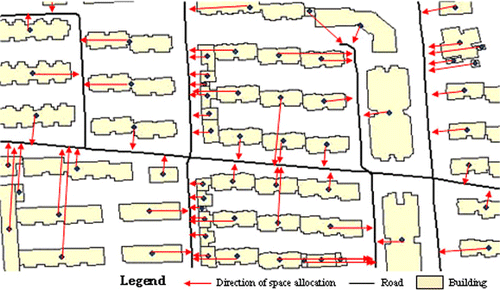
The traffic pressure level of the region, calculated by EquationEquation (11), was distributed to each building spatially, according to the capacity proportion of each building among all the buildings in the region.
The rule of the allocation direction was determined by Euclidean distance from the center of each building (pressure source) to the nearest road (pressure target), according to the real phenomenon that people prefer to select the nearest path to travel, and the building's exit is always opposite to the nearest road. Obeying the allocation rule, the traffic pressure carried by each building was divided into the nearest road (). Therefore, each road in the transportation network has its own traffic pressure score. Finally, the traffic condition level was calculated using the traffic pressure score divided by the width of the road.
4. Implementation, results, and accuracy analysis
4.1. Results of the simulation model implementing in the validation area
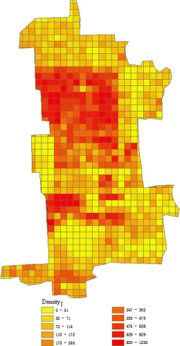
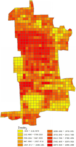
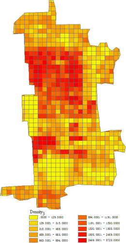
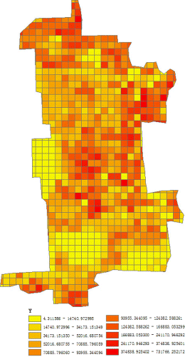
Dongcheng District of Beijing was used for evaluating our method from Section 3. The validation area was divided into proper size of grids. The cell size was determined on the basis of the principle that the 3D urban morphology can be represented by the indicators sufficiently in each cell and also can reduce the bias arising from too smaller or too larger grid. If the grid is too small to cover the maximum building occupation area, the height of the space in the grid will be a single value. Similarly, if the grid is too large, one cell will cover too many building types, volumes, and also too many different building height, which will obscure the 3D morphological characteristics of the entire sample space. On consideration of the maximum building occupation area, the minimum occupation area, and the majority occupation area, the validation area was divided into grids sized 250m×250m. The extraction results of the 3D urban morphology indicators are shown in Figures –, including building distribution density (), building area density (), height distribution density (), capacity distribution density (), otherness (), evenness (), and similarity () of the validation area. According to Equations (Equation9–Equation11), the spatial regression was computed to calculate the 3D urban morphology's impacts on road traffic pressure. The results are shown in .
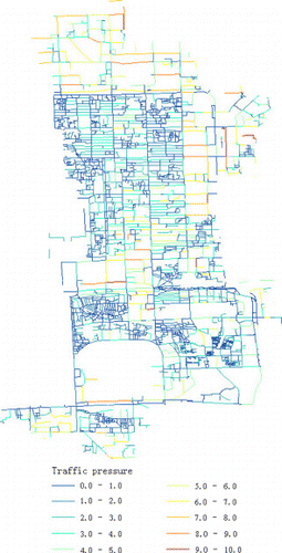
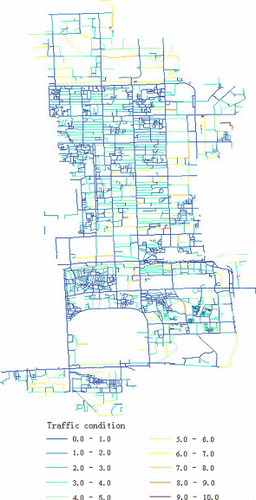
Then, the urban traffic pressure and conditions were calculated according to the algorithm in section 3.5. The results are shown in and .
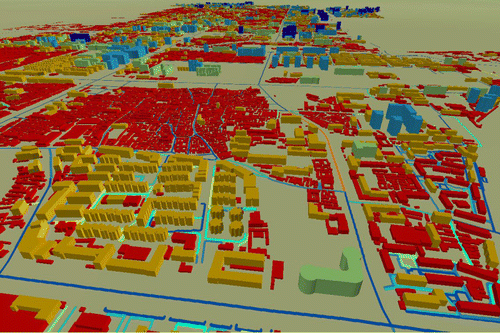
4.2. Showing the final results in a 3D digital earth
The simulation data of urban road conditions and the 3D building data of the urban space were loaded into the Digital Earth Science Platform. The Digital Earth Science Platform was developed by the Center for Earth Observation and Digital Earth, Chinese Academy of Sciences and is mainly used to explore, present, and exchange geoinformation. It visualized the relationship between the 3D urban morphology and the urban road condition from a 3D perspective ().
4.3. Accuracy analysis
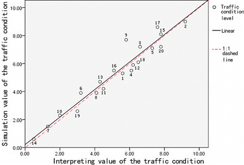
The validated roads were selected randomly from Dongcheng District. The real traffic condition level of the validated road was determined by the number of vehicles and estimated human flow density interpreted visually from aerial remote sensing images and high spatial resolution satellite images. The accuracy of the simulation result was evaluated by comparing the simulated traffic conditions with interpreted traffic conditions.
reflects that the validated sample results are generally the same as the simulated results, with a mean error less than 20%. The errors of sample 9 and sample 17 are relatively large because they are near a subway entrance. The subway diverts the ground traffic pressure, and therefore the simulated traffic pressure is greater than the validated sample's. This analysis also reveals that the subway plays an obvious part in reducing ground traffic pressure.
5. Discussion and conclusion
This study has indicated that, among these 3D urban morphology features, capacity distribution density has the most significant impacts on traffic condition. However, building distribution density is insignificant. Moreover, capacity distribution density and otherness are positively correlated to road traffic pressure, while building distribution density, building area density, height distribution density, evenness, and similarity are inversely proportional to road traffic pressure. depicts the trend line of traffic pressure affected by the urban space with each morphology indicator.
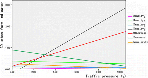
The results are supported by the following reasons. Capacity distribution density reflects the use density as well as the building capacity of planar urban space. The urban space with high use density and strong building capacity definitely gives more pressure to the transportation nearby. Moreover, the urban space with obvious otherness varies more obviously in building height level. It is likely to be composed of high building groups intermingled with low-rise buildings, such as commercial districts, public service districts with social services functions, or residential districts with dense high-rise apartment buildings. These crowded districts carry more people and heavier traffic flow that create much higher road traffic pressure. Therefore, the otherness in 3D urban space is positively correlated to the traffic pressure.
The urban spaces with high building distribution density or high building area density, in this study, are mostly residential districts with small low-rise buildings, in which buildings are densely distributed and occupy a large amount of land. This kind of urban space has fewer big buildings or high-rise buildings and is always used for personal living with fewer commercial or social service functions. These small buildings cannot carry as many people or as much traffic, so building distribution density and building area density are inversely proportional to the road traffic pressure. Meanwhile, this kind of urban space mostly has dense height distribution density because the number of buildings in it is always large. Thus, height distribution density is also inversely proportional to the road traffic pressure, represented typically by the courtyard blocks widespread in Beijing's Old City.
In the urban spaces with a greater evenness value, the shape of each building in a building group is uniform with less diversity. And the urban space with big similarity value generally has single type of building structure and also groups of clustered buildings with similar capacity. This kind of urban space is mostly residential with almost no high-rise buildings but buildings with similar shapes and capacities, such as low-rise apartment buildings or houses with courtyards. Such districts perform a single function and also have low population density, so their contribution to road traffic pressure is less obvious. Otherwise, the urban spaces with a small evenness value or small similarity value are mostly full of high-rise buildings with large differences in shape or capacity, such as versatile and crowded commercial districts as well as multi-functional blocks. Therefore, evenness and similarity of 3D urban spaces are inversely proportional to road traffic pressure.
Although single morphology density indicators or single urban structure indicators in an urban space cannot reflect their contribution to the pressure of traffic flow directly, a combination of these different indicators has the ability to reflect their contribution to the pressure of traffic flow. For example, if the urban space has small building evenness, as well as small building distribution density and large height distribution density, it could create relatively high pressure on transportation. The combination of these indicators demonstrates that the urban space should have all of the following features: more buildings, higher building height, and an uneven distribution of building entities. This kind of urban space probably has a certain amount of large buildings intermingled with several small buildings. It has huge building capacity in total and also performs multiple complex functions, so the transportation near it is heavy.
Acknowledgements
This research is supported by National Basic Research Program of China (973 Program, No. 2009CB723906) and National Natural Science Foundation of China (No. 41001267). The author would also like to acknowledge the anonymous reviewers helped to improve this article.
References
- Alexander, C. K., and M. N. O. Sadiku. 2007. Fundamentals of Electric Circuits. New York: McGraw-Hill.
- Bhatia, K. S. 2005. “Does Sprawl Cost More? The Influence of Urban Form on Public Transportation Expenditure.” M.Sc. thesis, State University of New York at Buffalo.
- Burchell, R. W., G. Lowenstein, W. R. Dolphin, C. C. Galley, A. Downs, S. Seskin, K. G. Still, and T. Moore. 2002. Transit Cooperative Research Program Report 74: Costs of Sprawl—2000. Washington, DC: National Academy Press.
- Cao, C., T. Strauss, R. R. Souleyrette, and R. D. Shinn. 1998. “Transportation and Urban Form: A Case Study of the Des Moines Metropolitan Area.” Transportation Conference Proceedings of Crossroads 2000, Ames, Iowa: Iowa State University Publisher, August 19–20, 232–237.
- Carty, J., and A. Ahern. 2010. “Mapping the Relationship Between Transport Energy Consumption and Urban Form Characteristics for the Greater Dublin Area.” Journal of Maps 2010: 160–168. 10.4113/jom.2010.1074
- Cetin, N., K. Nagel, B. Raney, and A. Voellmy. 2002. “Large-Scale Multi-Agent Transportation Simulations.” Computer Physics Communications 147 (1–2): 559–564. 10.1016/S0010-4655(02)00353-3
- Chen, Y., X. Li, Y. Zheng, Y. Guan, and X. Liu. 2011. “Estimating the Relationship Between Urban Forms and Energy Consumption: A Case Study in the Pearl River Delta, 2005–2008.” Landscape and Urban Planning 102 (1): 33–42. 10.1016/j.landurbplan.2011.03.007
- Gakenheimer, R. 1999. “Urban Mobility in the Developing World.” Transportation Research Part A: Policy and Practice 33 (7): 671–689. 10.1016/S0965-8564(99)00005-1
- Ge, S. S. 2009. “Study on Three Dimensional Urban Form Based on Urban DEM For Example the Old City of Nanjing.” PhD diss., Nanjing Normal University, China.
- Groeger, J. A., and J. A. Rothengatter. 1998. “Traffic Psychology and Behaviour.” Transportation Research Part F: Traffic Psychology and Behaviour 1 (1): 1–9. 10.1016/S1369-8478(98)00007-2
- Guindon, B., and Y. Zhang. 2007. “Using Satellite Remote Sensing to Survey Transport-Related Urban Sustainability Part II. Results of a Canadian Urban Assessment.” International Journal of Applied Earth Observation and Geoinformation no. 9: 276–293. 10.1016/j.jag.2006.09.006
- Jiang, B., and C. Liu. 2009. “Street-Based Topological Representations and Analyses for Predicting Traffic Flow in GIS.” International Journal of Geographical Information Science 23 (9): 1119–1137. 10.1080/13658810701690448
- Kenworthy, J. 1995. “Automobile Dependence in Bangkok: An International Comparison with Implications for Planning Policies.” World Transport Policy and Practice 3 (1): 31–41. 10.1108/13527619510089481
- Khisty, C. J. 1993. “Transportation in Developing Countries: Obvious Problems, Possible Solutions.” Transportation Research Board 1396: 44–49.
- Leading Group Office for Sixth Nationwide Population Census in Beijing. 2011. Data report for Sixth nationwide population census in 2010 of Beijing. Beijing Data Jun.: 66–67.
- Li, H. F. 2006. “Study on the Urban Form, Traffic Pattern and Resident Traffic Mode.” PhD diss., Southeast University, China.
- Liu, C., and Q. Shen. 2011. “An Empirical Analysis of the Influence of Urban Form on Household Travel and Energy Consumption.” Computers, Environment and Urban Systems 35 (5): 347–357. 10.1016/j.compenvurbsys.2011.05.006
- McMillan, T. E. 2007. “The Relative Influence of Urban Form on a Child's Travel Mode to School.” Transportation Research Part A: Policy and Practice 41 (1): 69–79. 10.1016/j.tra.2006.05.011
- Nagel, K., and M. Rickert. 2001. “Parallel Implementation of the TRANSIMS Micro-Simulation.” Parallel Computing 27 (12): 1611–1639. 10.1016/S0167-8191(01)00106-5
- Qin, Y., Z. Niu, W. Lin, X. Rui, and C. Wang. 2006. “Study on Digital Urban Planning Model.” Journal of Chongqing Jianzhu University 28 (4): 138–141.
- United Nations. 2007. Urban Indicators Database. United Nations Habitat. Nairobi: UN-Habitat.
- Zhang, M. 2005. “Exploring the Relationship Between Urban Form and Nonwork Travel Through Time Use Analysis.” Landscape and Urban Planning 73 (2–3): 244–261. 10.1016/j.landurbplan.2004.11.008
- Zhang, Y., and B. Guindon. 2006. “Using Satellite Remote Sensing to Survey Transport-Related Urban Sustainability Part 1: Methodologies for Indicator Quantification.” International Journal of Applied Earth Observation and Geoinformation 8: 149–164.