
Abstract
In these early years of the twenty-first century, we must look at how the truly cross-cutting information technology supports other innovations, and how it will fundamentally change the information positions of government, private sector and the scientific domain as well as the citizen. In those positions, location will be a prominent linking pin. The classical top-down system architectures of information exchange will be diluted by peer-to-peer and bottom-up channels, forcing us to rethink their designs. We should not only focus on better architectures, but need to attend to a different economy of information exchange, in which the ‘client’ is not only the information sink, but has become an important source as well. The laws of this rising ‘infoconomy’ have yet to be settled on. This special issue on ‘Digital Earth Applications: Technological design and organizational strategies’ brings together a number of papers that shed light on this future information ecosystem in which location-specific information will be exchanged between stakeholders. The introduction presents a framework that combines geoinformation streams and organisations brokering between government, science, private sector and citizens. This novel framework helps us improve the appreciation of those papers.
1. The role of information in modern and changing society
In these early years of the twenty-first century, advances in technology arrive on the scene with such frequency that we appear to be living not in an era of change, but in a change of eras. Robotics and autonomous transport, advanced materials and 3D printing and genomics all carry the potential to become fundamental game changers, and have been coined ‘disruptive technologies’ as they may change the economic and social landscape fundamentally (Manyika et al. Citation2013). None of them, however, is as pervasive as digital (information) technology, which by its generic nature is cross-cutting many fields of science and industry, and is offering the support without which the above fields would not have displayed the recent tremendous progress.
Indeed, information technology has been slow coming in a way compared to the others, but besides the functional support it lends to robots, material and genetic engineering, with the Internet and mobile revolution and advances in computation, it is now rapidly spreading its tentacles into all aspects of social life. As a consequence of the rapid proliferation of information (technology), we may expect information to reach stakeholders more rapidly and more transparently, disrupting previous balances in information positions. The communication game will change between government and its officials, private sector and its representatives, the scientific community and its members and indeed the general public.
The growing importance of information demands careful scrutiny of the processes that we design to support its exchange. Where these have been traditionally mostly top-down, from government to citizen, from private sector to client and from scientific organisation to student, simply because the first in each of those equations had a monopoly on the channels, such monopolies are now waning and the historic receivers are also becoming empowered as information sources. In this changing context, former information-brokering strongholds such as the traditional media have a hard time adjusting.
While traditional downstream information channels will continue to exist and evolve, other channels are quickly becoming a reality, and pose challenges to the information architect. Upstream information channels are those in which the traditional receivers are now information sources, giving rise to novel models of information exchange. This fuels new ‘business models’ in which those who have populated the bottom-of-the-pyramid can now raise their voice, in the context of public governance issues, or in commercial demand, or as citizen participant in scientific endeavours. The upstream information channels can be exploited in modern feedback loops to higher pyramidal ranks, allowing much more rapid system responses.
As social and technological developments continue to empower the bottom-of-the-pyramid as sending and receiving end in information channels, sidestreaming also becomes possible. With this, we mean information exchange between peers. We expect it to become a foundation under the horizontal society, in which like-minded stakeholders (citizens but also stakeholders at other ranks in the pyramid) start to display strong self-organisation.
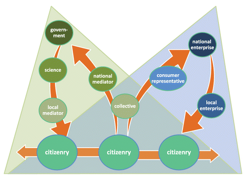
Fundamental questions arise in the domains of economy (who pays for what?), authority and trust (is this information true?), ownership (what can be done with this information?) and privacy (to what level is this information exploitable?). illustrates typical information streams in the governance (left) and commercial (right) pyramids; these are just two prominent pyramids that illustrate our points, and other pyramids also exist. The figure also makes visible important intermediaries, i.e. organisations brokering information in the governance pyramid (national mediator, citizen collectives) and in the commercial pyramid (citizen collectives/cooperatives, consumer representatives, local enterprises).
2. Applications of geospatial information
Geospatial information carries implicit or explicit location knowledge. Such knowledge has tremendous combinatorial power as ‘extra join attribute’, as it allows enriching our picture of local context. That power is hard to overestimate: it links government action to voter homestead, origin of produce to consumer dish and trucker with post-harvest losses, and it brings together like-minded citizens over common interests.
In future information chains that involve down- and upstreams, spatial information from the skies can be matched with spatial information from the ground and crowd, allowing unprecedented opportunities of model gauging and enrichment, even though crowd-sourced information has its challenges in standards, calibration and trust. In applications that use sidestreaming, context similarity based on location intelligence will allow exploring further the potential of community knowledge. This will, without doubt, put our planet under this digital looking glass, and help us develop a deeper understanding of the natural and man-made processes on its surface. It might help us to develop more rapid plans of action when things go astray, and it could bring methods that allow more location-sensitive remedies.
Generally, geospatial information is hard to work with methodically, and can be harmful in the hands of the untrained. This is to state that there is a role for geoinformation brokers, who accommodate the downstreaming in terms of curation and packaging, who evolve their business over recombining heterogeneous data sources, and who exploit the power of the crowd by turning upstreaming into effective grand survey technology. In that business, independent validators also may find opportunities : government, science and the financial sector will want to use confidence intervals over the crowd-sourced data.
3. Infoconomy rules
Information is a strange commodity, and geoinformation is no exception. Its valuation defies some of the natural laws that we know well for the more physical commodities. For instance, duplication of information does not mean we double its value, and exchange of information from one party to another does not mean the first has lost value in that transaction, or that the second has gained as much value as the first party had with it. While information obviously represents value that value comes from the pairing with other commodities, and this makes it hard to assign value to information in isolation. As a consequence, the assignation of hard currency to pieces of information is highly arbitrary.
We expect that the information society will see a maturation of economic information exchange models, in which parties agree to information exchange for mutual benefit, and not involving any direct payments. Such agreements are likely in many scenarios: between government and citizenry where the latter report damages in public space, between science institutes and entrepreneurs on timely business intelligence and between commercial producers and consumers on product acceptation and certification. In all of this, location can again become a highly prominent parameter.
4. Papers in this issue
In context of the above framework, this issue of the International Journal of Digital Earth, titled ‘Digital Earth Applications: Technological design and Organisational Strategies’ displays a thought-provoking array of articles, addressing many of the mentioned types of information stream.
Morales and de By (Citation2013) address the generic technological question of appropriate software architectures for modern geodata-intensive applications, recognising that many of the sources are web-served, and arguing for more open functional environments. Vilches-Blázquez et al. (Citation2013) make a strong case for further data augmentation, next to location as the linking pin, through the linked data metaphor, which will deepen the possibilities for data recombination. Both papers apply mostly to downstreaming, with the latter more likely to be realised first in the governance pyramid of .
Bernard et al. (Citation2013) take up the case for science in the governance pyramid and describe requirements for well-designed scientific data infrastructures. Whilst such systems initially appear to be of the downstreaming type, their original intent and client community are strongly oriented towards sidestreaming. Though in the domains of application strongly related to that paper, the work by Schade and Granell (Citation2013) reports on a deep analysis of requirements on geospatial applications in which upstreaming is the primary characteristic. Their identification of challenges in stakeholder networks of the future digital earth living lab will prove to be an important area of research in the coming years.
Mooney and Corcoran (Citation2013) focus on the characteristics of sidestreaming – the collaborative, crowd-based editing of geospatial information in OpenStreetMap (OSM) – and suggest ways on how OSM can be best integrated into the fabric of digital earth, while Georgiadou, Lungo, and Richter (Citation2013) discuss how (geo)information brokers mediate to government officials sidestreamed information on the functioning of public services.
Acknowledgements
We are grateful to Prof. Dr. Changlin Wang, Executive Editor of the International Journal of Digital Earth, for his support during the preparation of this special issue.
References
- Bernard, L., S. Mäs, M. Müller, C. Henzen, and J. Brauner. 2013. “Scientific Geodata Infrastructures: Challenges, Approaches and Direction.” Accessed April 10. doi:10.1080/17538947.2013.781244
- Georgiadou, Y., J. H. Lungo, and C. Richter. 2013. “Citizen Sensors or Extreme Publics? Transparency and Accountability Interventions on the Mobile Geoweb.” Accessed May 8. doi:10.1080/17538947.2013.782073
- Manyika, J., M. Chui, J. Bughin, R. Dobbs, P. Bisson, and A. Marrs. 2013. Disruptive Technologies: Advances That Will Transform Life, Business and the Global Economy. McKinsey Global Institute, 180. Accessed July 27. http://www.mckinsey.com/insights/business_technology/disruptive_technologies
- Mooney, P., and P. Corcoran. 2013. “Has OpenStreetMap a role in Digital Earth Applications?” Accessed April 10. doi:10.1080/17538947.2013.781688
- Morales, J., and R. A. de By. 2013 “Cyber-applications as Gateway to Data-rich Digital Earth Systems.” Accessed April 23. doi:10.1080/17538947.2013.788224
- Schade, S., and C. Granell. 2013. “Shaping Digital Earth Applications through Open Innovation: Setting the Scene for a Digital Earth Living Lab.” Accessed June 9. doi:10.1080/17538947.2013.804600
- Vilches-Blázquez, L. M., B. Villazón-Terrazas, O. Corcho, and A. Gómez-Pérez. 2013. “Integrating Geographical Information in the Linked Digital Earth.” Accessed April 17. doi:10.1080/17538947.2013.783127