
Abstract
The use of spatial data has become a key factor in numerous public sector processes. However, recent evidence suggests that the seemingly obvious benefits of spatial data use and sharing often stay beyond reach. This paper examines whether the performance of spatial data in inter-organisational processes depends on the structural characteristics of the process involved. Process structure here refers to the way in which tasks are divided and coordinated between the organisations in a process chain, and to the allocation of the spatial data handling tasks in that process. Spatial data performance describes the level of access, use and sharing of spatial data in the process. The paper presents the results of a comparative case study of inter-organisational public sector processes in the fields of urban planning, flood management, population registration, environmental permit delivery and road safety monitoring. The findings suggest that spatial data performance in inter-organisational processes depends on the interplay between the structural characteristics of the process. Unfragmented processes with embedded activities that are related to spatial data are apparently linked to a high level of spatial data performance, while fragmented processes without centralised coordination, or processes in which the spatial data-related activities are separated from the actual process, seem to relate to lower levels of spatial data performance.
1. Introduction
Spatial data are digital data that relate to a location on the Earth (Longley et al. Citation2001). The use of spatial data has increased considerably over the last few decades, and it has been acknowledged that this is a key factor in governmental decisions and private businesses (Janssen Citation2010). Spatial data are also increasingly used by researchers, not-for-profit organisations and individual citizens (Longhorn and Blakemore Citation2008). Over the past two decades, there has also been a shift towards the shared use, and hence exchange, of spatial data across different organisations. Various initiatives have been taken to promote and optimise spatial data access, use and sharing. As a whole, these initiatives are often referred to by the term spatial data infrastructure (SDI). The concept has gradually shifted its focus to supporting policy processes (Harvey et al. Citation2012).
Digital Earth is a global initiative that has the aim of constructing a comprehensive virtual representation of the planet (www.digitalearth-isde.org). The vision of Digital Earth includes the development of multiple connected infrastructures addressing the needs of different audiences (Craglia et al. Citation2008), among which are the various national and regional SDIs worldwide. Because the typical SDI users are public and private organisations, the actual spatial data access, use and sharing takes place within the processes of these organisations. A process is the sequence of steps involved in producing products and services (Daft Citation2001). It usually takes the form of a series of interrelated activities, which turn a certain input of resources into an output of products or services. Previous studies on poverty management (Akinyemi Citation2007), local planning (Nedović-Budić et al. Citation2004), spatial planning (Vonk, Geertman, and Schot Citation2007) and catchment management (Paudyal Citation2012) focused on the integration of spatial data in actual processes. It should be noted that many of the processes in which spatial data are involved are typically not confined to the borders of a single organisation (McDougall, Rajabifard, and Williamson Citation2007).
The various SDI developments undeniably have generated benefits for numerous fields of application within the public sector and beyond (Longhorn and Blakemore Citation2008). Craglia et al. (Citation2008) point out that many elements of the Digital Earth vision are now regularly being used by large numbers of people throughout the world. However, based on a literature review, Nedović-Budić, Pinto, and Warnecke (Citation2011) concluded that the seemingly obvious benefits of spatial data use and sharing in inter-organisational processes often stay beyond reach. A similar conclusion was made by Diaz et al. (Citation2012), who argue that SDIs so far have failed to achieve the desired level of impact and penetration.
This paper examines whether the extent to which spatial data access, use and sharing can become an integrated part of inter-organisational processes may depend on the structural characteristics of the processes involved – in particular on the way tasks are divided and coordinated between the organisations in the process chain. The enabling aim of Digital Earth as a global initiative to improve social conditions, protect the environment and support future sustainable development (www.digitalearth-isde.org) is likely to depend on the integration of Digital Earth technology in the actual processes at stake. This paper seeks to address the question: ‘What is the relation between the inter-organisational process structure and the level of spatial data performance in the inter-organisational process?’ Spatial data performance here describes the level of access, use and sharing of spatial data in the process. This research question will be further explained in the section ‘Theoretical framework’.
The paper is divided into six parts. This introduction has described the background to the paper and introduced the research question. The next part presents the theoretical framework. The third part proposes a conceptual model that should allow analysis of the relation between process structure and the spatial data performance. The fourth part presents the results of an extensive case study that was performed in the region of Flanders (Belgium) between 2009 and 2011. In the fifth part, these results are discussed and interpreted in the light of other published findings. The paper ends with some concluding remarks and implications for further research.
2. Theoretical framework
Organising a process involves providing the conditions for the process to reach its goals (products and services meeting the needs of their users and society at large). Among these conditions, the way tasks or process steps are identified, grouped and coordinated plays a fundamental role (Simons Citation2005). Individual behaviour, organisational culture and social relations are also crucially important to making processes successful. However, a systems view of organising (Achterbergh and Vriens Citation2009) regards the structures of task division and coordination as the basis on which the other aspects rest.
The present research is mainly based on the Modern Socio-Technical Systems (MSTS) approach (De Sitter, den Hertog, and Dankbaar Citation1997). The term socio-technical systems was originally coined in the 1950s by Trist and Bamforth (Citation1951) in the UK. Trist et al. (Citation1963) used the term ‘organisational choice’ to indicate that work organisations do not necessarily need to conform to the prevailing Tayloristic and bureaucratic principles because design alternatives are possible. MSTS was further developed and applied in North America, Australia and Scandinavia. The MSTS framework for analysis and design of processes and organisations (De Sitter, den Hertog, and Dankbaar Citation1997; Achterbergh and Vriens Citation2009) is based on cybernetics (Ashby Citation1957) and social systems theory (Luhmann Citation1984). MSTS is about processes at various levels, ranging from a production unit, a department, an entire organisation or a network of organisations to a complete business sector (De Sitter Citation2000). MSTS argues that the structures of task division and coordination create the necessary boundary conditions that meet the external demands. Based on Ashby's (Citation1957) law of requisite variety, MSTS states that the variety of control mechanisms must be greater than or equal to the variety of interferences. In other words, the coordinating capacity of an organisational unit should be in proportion to its coordinating needs. A high level of inter-organisational task division can be very effective in dealing with efficiency demands because the internal efficiency of every process step can be maximised. The coordination needs are then usually limited because routine tasks can be standardised and allow central coordination (Daft Citation2001). However, environmental developments have challenged this model in both the private (Hammer and Champy Citation1993) and the public sectors (Osborne and Gaebler Citation1992). As a result of this evolution, processes are confronted with increasing demands for flexibility and innovation (Van Hootegem et al. Citation2008). They are becoming less predictable, routine and transparent. The need for coordination is increasing. A highly fragmented inter-organisational structure is likely to have difficulty in meeting these needs. On the one hand, each organisation controls only a small step in the entire process. On the other hand, every organisation has to deal with many processes and their connected demands. It is hypothesised here that, given the level of complexity and dynamism of the current social environment, fragmented inter-organisational structures may not provide the best option for achieving a high-performing integration of spatial data access, use and sharing in inter-organisational processes.
The relevance of the given inter-organisational task division in relation to spatial data access, use and sharing is stressed by several authors of previous research. Nedović-Budić et al. (Citation2004) examined the structural characteristics of interaction mechanisms between organisations, concluding that spatial data sharing efforts involve a redefinition of existing tasks and structures and the establishment of new ones. In an earlier study, Nedović-Budić and Pinto (Citation1999) found that less complex and unambiguous inter-organisational structures can diminish the resistance to inter-organisational data sharing. Lance, Georgiadou, and Bregt (Citation2009) found that a certain level of external steering, exercised by authoritative bodies through hierarchical means, may invigorate cross-agency coordination. As for the place of activities related to spatial data in inter-organisational processes, Artigas, Elefante, and Marti (Citation2009) studied the development of an inter-organisational spatial planning geographic information system (GIS) and found that the differences in levels of spatial data-related expertise between the organisations involved was one of the main challenges that is encountered. Finally, according to Cooper et al. (Citation2013), the building and maintenance of organisational structures to maintain the SDI and also the management of daily SDI activities are key challenges in SDI implementation.
3. Conceptual model
In order to be able to operationalise the research question, a conceptual model in which the main variables and their interconnections are shown was developed (). An overview of the definition of the variables can be found in .
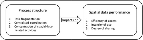
Table 1. Definition of the variables.
As can be seen on the right of , spatial data performance reflects the idea that an SDI should facilitate spatial data access, use and sharing (Masser Citation2010). The variable efficiency of access relates to the extent to which it is easy to find the spatial data needed in the process, and to the efforts that are needed before the data can be used in the process. The variable intensity of use is intended to capture the degree to which spatial data are used in the various steps of the process. The variable degree of sharing refers not only to the extent of the stakeholder group with whom the spatial data resulting from the process are shared in practice, but also to the content of the sharing (e.g. static maps, web services or the full datasets). Smooth access to the necessary spatial data, intensive use of the spatial data in the different steps of the process and a ready availability of the spatial data related to the output of the process would be expected to add to the level of spatial data performance for that process (Vandenbroucke et al. Citation2013).
As stated in the Introduction section, the research question concerns the extent to which the level of spatial data performance in an inter-organisational process may depend on structural process characteristics. This relation is indicated by the arrow in the middle of . On the left-hand side of the figure, the process characteristics are shown. The process structure concept is formulated as three variables: task fragmentation, centralised coordination and concentration of spatial data-related activities.
The first variable is the level of task fragmentation in the inter-organisational process. It refers to the extent to which the different tasks in the execution of (an instance of) the process are distributed across various organisations. The value of this variable is low when each organisation is responsible for the entire (instance of a) process. Its value is high when the process is fragmented across multiple organisations. The concept of process structure relates not just to this task division but also to the coordination and control of the allocated tasks. The variable centralised coordination varies from centralised (high), meaning that the coordination and control of the process is exercised largely by a central organisation or by legislative arrangements, to de-centralised (low), meaning that the coordination and control is largely in the hands of each of the organisations involved. Also, as this research specifically focuses on the role of spatial data, the allocation of the spatial data-related activities in the inter-organisational process is separately assessed. The variable concentration of spatial data-related activities refers to the degree of separation of spatial data collection, use and distribution from the other activities related to the process. This variable has a low value when the spatial database knowledge and the application of it that are necessary for the process are largely present within the various organisations involved in the inter-organisational process. Conversely, when this knowledge and its application are concentrated at one of the organisations involved in the process, or even outside the actual process (for example at a national SDI agency), the level of concentration of the spatial data-related activities is high.
It should be made clear that the concentration of the spatial data-related activities is different from the spatial data performance of the process. While concentration of the spatial data-related activities refers to the position of (possible) spatial data-related activities with regard to the other activities that are part of the process, spatial data performance is about the actual incorporation of spatial data access, use and sharing in the process as a whole. Concentration of the spatial data-related activities refers to the question of whether concentrating spatial data-related process tasks in a specialised organisation offers the best chance of a high level of spatial data performance for the process or whether distributing them to the various organisations in the process chain would be a better option.
The next section describes the application of this conceptual model in a piece of research based on a case study.
4. Case study
Since this research aims to assess how and why contemporary differences in process characteristics impact on the actual performance of spatial data in specific inter-organisational processes, performing a case study seemed to be the most appropriate method of making such an assessment. The case study used focused on the public sector in the region of Flanders (Belgium).
This part of the paper is composed of five sections. The first section contains some methodological remarks about the case selection and the assessment of the variable values. Second, the four cases that were part of the study are presented. Third, the level of spatial data performance is assessed for the four cases. Fourth, the process structure is described for each case. Finally, in the fifth section, the process structure of each case is compared with the respective level of spatial data performance.
4.1. Method
The case corresponds to the unit of analysis, which is defined as an inter-organisational process in which spatial data are accessed, used and shared. Since the research objective is to study the possible impact of process structure on spatial data performance, the variables describing the process structure can be regarded as the independent (or explanatory) variables, while the variables describing spatial data performance are the dependent variables. In order to be able to assess the impact of different process structures, the case selection was based on contrasting process structures. The assessment of the (expected) mutual divergence of the candidate cases with regard to process structure was based on explorative interviews and document analysis. This selection strategy is in line with the methodological literature, which states that case selection on the basis of independent variables is preferable. The reason given for this is that a selection on the basis of dependent variables often leads to erroneous answers, in the sense that connections are discovered that do not really exist, while other connections may remain concealed (Geddes Citation1990). Four cases were selected: the Zoning Plans case; the Flood Maps case; the Addresses case; and the Traffic Accidents case. Note that the four cases are from different policy domains. The processes involved were considered to be suitable cases because of their expected variety in process structure, thus allowing the examination of the relation between process structure and spatial data performance.
Within each process, a selection of five to eight key organisations was made. The criterion for selection was that the selection should provide sufficient information to describe the process structure and spatial data performance of the case in question. Within each of these organisations, the following people were interviewed about spatial data performance and process structure: the process owner (such as a spatial planner in the Zoning Plans case), a GIS user or expert involved in the process, the GIS manager of the organisation and an organisational development manager. Information was collected in semi-structured, in-depth interviews. The interviews were recorded, transcribed and coded. Furthermore, relevant documents – including organisation charts, process diagrams, inter-organisational agreements and legislation – were collected. The information from the interviews and the collected documents was summarised and cross-checked with the interviewees. The resulting scoring was discussed and agreed upon by the five research team members (coming from different disciplines). In a later phase, the people who had been interviewed were invited to a workshop to discuss the results of the analysis. The main findings were agreed upon – i.e. the scoring according to the different classes and thus the ‘ranking’ of the different processes with regard to their spatial data performance and process structure. This combined and iterative analysis of information from different sources contributed to the construct validity of the research. The research reports, transcripts, consulted documents, etc. were systematically stored and are available for future further analysis of the reliability of the research.
The design of the research described in this paper is qualitative in nature. The conceptual model and the set of variables that were presented in the section ‘Theoretical framework’ were conceived as tools for guiding the data collection, analytically categorising the data, identifying regularities and ensuring comparability between the four cases (Miles and Huberman Citation1994). The following method was used to assess the variable values. First, a description was made of the status of the cases for each of the variables, based on the interview transcripts and the collected documents (such as organisation charts). Second, the cases were compared in order to assess their relative position for each variable on a five-point scale (low, medium/low, medium, medium/high, high). It should be noted that the qualitative scale was applied as a tool to structure the data, in order to facilitate the comparative analysis. The technique of pattern matching (Yin Citation2003) was then used to compare the empirical patterns. Pattern matching is based on the comparison of patterns in order to determine whether they match (i.e. that they are the same) or do not match (i.e. that they differ). The method can be defined as holistic as it analyses whether configurations of variables, rather than individual variables, might be linked to a certain outcome.
4.2. The four cases
As can be seen from , the cases studied encompass inter-organisational processes with specific spatial data components.
Table 2. Overview of the four cases.
Urban and regional planning was the first of the four processes selected for the case study. In Belgium, the regional, provincial and municipal levels of government are each authorised to develop Zoning Plans, which are generally concerned with the development of a specific area ranging from a single parcel of land to an entire city district (RWO Citation2008).
The second case concerned the process of flood management and prevention and examined how various organisations contribute to the identification of recently flooded ground, how they create models of flooded areas, and how they contribute to the delineation of reservoir areas (or buffer zones) to hold water in the event of flooding (VMM Citation2007).
The third case focused on the process of population registration and environmental permit delivery. In this case, a look was taken at the way in which addresses are created, used and exchanged at the municipal and at the provincial level.
In the domain of road safety monitoring and policy, spatial data are increasingly used for the recording of Traffic Accidents in order to monitor progress in road safety and to evaluate road safety policy (Van Malderen et al. Citation2009). The fourth case, therefore, focused on the acquisition, use and sharing of Traffic Accident data.
4.3. Spatial data performance
The efficiency of access, the intensity of use and the degree of sharing of spatial data were recorded for the selected processes. summarises the totals for the resulting level of spatial data performance. Rather than a simple addition of the values of the three variables, the values for spatial data performance were chosen to represent the qualitative differences between the cases, based on their descriptions for the three variables involved. The assessment separates the Zoning Plans and the Flood Maps cases (high) from the Addresses and the Traffic Accidents cases (low).
Table 3. Spatial data performance.
The Zoning Plans and the Flood Maps cases both have high levels of efficiency of access. No complex or time-consuming data access arrangements were found for these cases, and most of the datasets can be used directly without much need for preparatory processing. shows that the Zoning Plans and the Flood Maps cases also have the highest values for intensity of use. In both cases, spatial data are used on a daily basis by the majority of the people involved in the process. In addition, the data are used not only for simple consultation but also for more advanced analytical applications. The Zoning Plans case received only a medium/high value because the spatial data use is largely limited to a specific phase of the process (i.e. plan design). With regard to the degree of sharing, Zoning Plans and Flood Maps are generally made available without much limitation to external parties. In the Zoning Plans case, fixed mechanisms are in place to exchange Zoning Plans between the stakeholders in the process, while in the Flood Maps case data exchange is not always done in a systematic way.
The Addresses and the Traffic Accidents cases both have a low level of spatial data performance. Regarding the efficiency of access, the inter-organisational process in the Traffic Accidents case is delayed to a considerable extent by the need for particular agreements, by specific conditions on spatial data use, and by the fact that each organisation involved is constrained to make important changes to the spatial and related accident data in order to be able to use them. In the Addresses case, the lack of unified data collection and management in the inter-organisational process, and the involvement of multiple organisations, seems to necessitate considerable efforts to collect and process the data needed. However, address data management in the context of population registration is more streamlined than it is in environmental permit delivery. Because of this mixed situation, the Addresses case has a medium value for efficiency of access. As for intensity of use, spatial data are hardly used in the actual process of address creation and management. Address management is often seen as a purely administrative process without much reference to the spatial context. In the Traffic Accidents case, the use of spatial data is variable along the inter-organisational process chain. Some organisations use hardly any spatial data, while other organisations make more intensive use of spatial data. More advanced analytical use seems, however, not to be very common. Both the Addresses and the Traffic Accidents cases were given a low value for degree of sharing, but not for the same reason. In the Addresses case, hardly any exchange could be observed because each department manages and uses its own address datasets. In addition, the apparent lack of use of the geographically linked Central Reference Address Database (CRAB) that is available for the whole Flemish region was striking. In the Traffic Accidents case, the exchange of locational and descriptive accident information was limited, due to a number of relatively severe restrictions on the use and exchange of information.
The variation in spatial data performance found between the four cases allowed the potential explanatory value of the differences in the process characteristics to be explored.
4.4. Process structure
As can be seen from , the concept of process structure is formulated into three key variables: task fragmentation, centralised coordination and concentration of the spatial data-related activities.
Table 4. Process structure.
The variable task fragmentation refers to the extent to which the different steps in the execution of (an instance of) the process are functionally distributed across various organisations. The level of task fragmentation in the Zoning Plans case was assessed as low. The inter-organisational task division is based on the principle that every government organisation that has the authority to make Zoning Plans is responsible for every step in the development of a specific Zoning Plan. The second variable is centralised coordination, which was assessed as medium for the Zoning Plans case. The Flemish decree on Spatial Planning contains the rules for the development of Zoning Plans at all three levels of government. Apart from the legal framework, the actual development of a Zoning Plan is mainly in the hands of the organisation that initiates the procedure. The case as a whole thus seems to consist of loosely coupled processes. The third variable concentration of the spatial data-related activities relates to the degree of separation of the spatial data-related activities from the other activities in the inter-organisational process and was assessed as being low for the Zoning Plans case. Each organisation is responsible for the entire process of development of a Zoning Plan, including the spatial data-related activities.
The Flood Maps case encompassed organisations with rather different (sub-)processes, such as water modelling, water-level monitoring and reservoir management. Each organisation is mainly in charge of its own (sub-)processes from beginning to end although, at a more general level, the inter-organisational task division with regard to actual water management is still largely organised along functional and administrative lines, which also seems to impact the Flood Maps process. The level of task fragmentation in this process was therefore assessed as medium. The value of the second variable centralised coordination was also medium. Each organisation is mainly in charge of its own Flood Map-related activities, although frequent inter-organisational consultation can be seen. At a more general level, an extensive consultation structure has been set up in order to produce an integrated water management policy which ensures that all authorities, administrators and interest groups work together to manage the water system in a sustainable way. As for the third variable, the level of concentration of the spatial data-related activities was assessed as medium/low. Each organisation is largely responsible for the spatial data-related activities with regard to their Flood Map-related tasks.
In the Addresses case, each organisation mainly manages its own address data within the context of its various activities (like population registration). The level of task fragmentation in the process was, therefore, assessed as low. The level of centralised coordination for the Addresses case was assessed as being medium/low, although several forms of inter-organisational coordination of address management were noted. However, these initiatives are only indirectly aimed at coordinating address management: instead, their focus is the management of thematic data (with regard to population and businesses). At the time of the interviews, the CRAB, which was created by and is managed by the Flemish Agency for Geographic Information, seemed to be rarely used in actual address management by public sector organisations in Flanders. Since the geocoding of addresses and the subsequent use of these addresses seemed to be largely separated from the actual address management in the context of thematic procedures like population registration and environmental permit delivery, the level of concentration of the spatial data-related activities was assessed as high.
In the Traffic Accidents case, each organisation represented a step in an inter-organisational process chain involving local and federal police departments, the national statistics agency and various departments of the regional, provincial and municipal administrations. Due to the high degree of fragmentation of the process steps across multiple organisations, the level of task fragmentation in the process was assessed as high. The Traffic Accidents case also displayed many coordination problems between the different organisations involved. The level of centralised coordination for the Traffic Accidents case was, therefore, assessed as low. The organisations involved appeared to have little influence on the execution of the steps which are carried out by other organisations, and problems seem to propagate through the process chain. It could also be seen that organisations often duplicate one another's work. Discussions about the ownership of the collected and processed data then arise. Alignment efforts mainly consist of bilateral arrangements, which short-circuit the process by (informally) eliminating one of the organisations involved, or consultation between several of the different organisations. As for the third variable, the level of concentration of the spatial data-related activities was assessed as medium/low since most of the spatial data-related activities are in the hands of the various organisations. Multiple organisations undertake (uncoordinated) efforts for geocoding Traffic Accident locations, thereby partly duplicating one another's work.
Overall, there was considerable divergence in the values of the process structure variables for the four cases described above. The next section discusses the relation between these process structure variables and the level of spatial data performance in inter-organisational processes.
4.5. Relation between process structure and spatial data performance
The assessment of the level of spatial data performance that was presented in the section ‘Spatial data performance’ separated the Zoning Plans and the Flood Maps cases (high level of spatial data performance) from the Addresses and the Traffic Accidents cases (low level of spatial data performance). This section examines whether the structural characteristics that were discussed in the previous section could be linked to the level of spatial data performance that was achieved by the four cases. Apart from tabular overviews, radar charts are also presented in this section.
As can be seen from , no strong relation can be found when comparing each individual process structure variable with the spatial data performance variable. As for task fragmentation, the findings for the Zoning Plans and the Traffic Accidents cases seem to indicate that a low level of task fragmentation relates to a high level of spatial data performance (and vice versa). However, the findings for the Flood Maps and Addresses cases apparently contradict this observation. As for centralised coordination, the findings seem to suggest that a limited (medium) level of centralised coordination in the inter-organisational process is needed to reach a high level of spatial data performance. The relation between spatial data performance and concentration of the spatial data-related activities is not straightforward: The Zoning Plans and Flood Maps cases combine medium/low levels of concentration of the spatial data-related activities with a high level of spatial data performance whereas, for the Addresses case, high levels of concentration of the spatial data-related activities are combined with a low level of spatial data. However, the data for the Traffic Accidents case deviate from this pattern.
Table 5. Process structure and spatial data performance.
Despite all of the above, a combined analysis of the three process structure variables leads to interesting findings. combines the three process structure variables for each of the cases. Each radar chart applies to a single case. The chart consists of a sequence of equi-angular spokes, with each spoke representing one variable. The data value on each spoke is proportional to the magnitude of the corresponding variable for the case involved. A line is drawn connecting the data values. This type of radar chart is used to display the pattern of a group of variables for a single case. The values of the process structure variables are converted as follows: high = 5, medium/high = 4, medium = 3, medium/low = 2, low = 1. These radar charts allow the identification of the differences between the cases in terms of the patterns in the values of the three process structure variables.
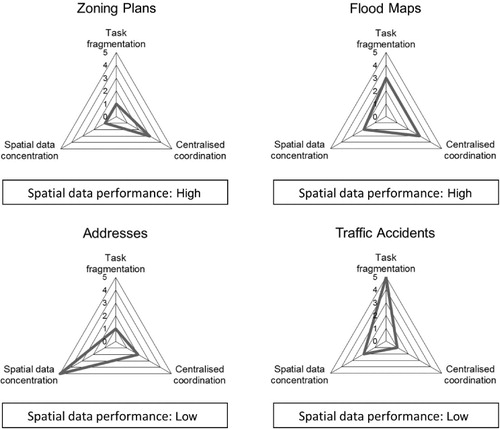
Both the Zoning Plans case and the Flood Maps case combine a low to medium level of task fragmentation with a medium level of centralised coordination, indicating that the processes are largely in the hands of separate organisations but with a clear degree of coordination between them. Moreover, both cases have a low to medium/low level of concentration of the spatial data-related activities, indicating that the spatial data-related activities are mainly integrated into the work of the various organisations involved.
The Addresses case combines a low level of task fragmentation with a medium/low level of centralised coordination. Address management is strongly integrated into the various processes which it supports, and some limited inter-organisational coordination is present, primarily linked to these supported processes. However, the concentration of the spatial data-related activities in the various processes is high. In other words, the creation of, and working with, geocoded addresses seems to be largely separated from the processes in which the actual address management takes place. These findings suggest that the availability of the CRAB may have led to a parallel use of geocoded addresses in GIS applications, but mainly without a connection to the actual address management in the separate processes. In particular, the low value for spatial data performance in the Addresses case might be related to this separation.
Finally, the Traffic Accidents case combines a high level of task fragmentation with a low level of centralised coordination. The different process steps are fragmented across multiple organisations, and hardly any centralised coordination seems to be present. The low level of spatial data performance in the Traffic Accidents case might be related to this combination because especially processes with a high level of internal task fragmentation would require far-reaching centralised coordination efforts. The concentration of the spatial data function is medium/low, indicating that most of the spatial data-related activities are in the hands of the various organisations involved. However, the shortage of centralised coordination between these organisations already mentioned apparently leads to overlapping activities, and especially to low levels of spatial data access and sharing (as described in the section ‘Spatial data performance’).
In short, the findings suggest that an unfragmented process with embedded spatial data activities could be linked to a high level of spatial data performance. Fragmented processes without equivalent coordination efforts (Traffic Accidents case), or the separation of the spatial data-related activities from the process (Addresses case), may lead to lower levels of spatial data performance in the process.
Although the findings show that the centralised coordination variable could be related directly to the spatial data performance variable, indicating that a certain level of centralised coordination in the inter-organisational process is anyway needed to reach a high level of spatial data performance, the most striking result to emerge from the data is that the combined analysis of the three process structure variables, in particular, leads to interesting findings. This indicates that the possible impact of a single variable might be counterbalanced (or strengthened) by another variable. Conversely, it could also be said that an extreme value for even one variable is enough to endanger the chances of successfully integrating spatial data into the process.
5. Discussion
As mentioned in the Introduction section, the analysis that is presented in this paper focuses on public sector processes in order to address the research question concerning the possible relation between the inter-organisational process structure and the level of spatial data performance in the process. Although only a limited linear relation with one of these process structure variables (the centralised coordination) was found, specific combinations of values of process structure variables seem to be linked to different levels of spatial data performance. These findings point to the connection between task division, coordination and the allocation of spatial data-related activities in inter-organisational processes. Specific combinations of variable values, rather than individual variable values, could be linked to spatial data performance. This result is in line with De Sitter, den Hertog, and Dankbaar (Citation1997), who state that task division and coordination are interlinked. An inter-organisational process with a highly fragmented task division, such as the Traffic Accidents case, might require very centralised coordination, whereas an inter-organisational process with a low level of task fragmentation, such as the Zoning Plans case, might offer opportunities for somewhat more decentralised coordination.
The question of how to reach a high level of spatial data performance in inter-organisational public sector processes could be regarded as a specific case of a more general issue. The underlying challenge can be noticed in various other situations in which organisations engage together in an endeavour that may not directly support their own core objectives. Organisations traditionally focus on realising their core objectives (Goedee and Entken Citation2008); many societal issues, however, call for an integrated approach. Exactly this need for an integrated approach is also invoked to promote SDI developments in support of economic, social and environmental challenges (Rajabifard, Feeney, and Williamson Citation2003). Such an integrated approach can only be reached by in-depth cooperation between multiple organisations (Goedee and Entken Citation2008). When many specialised organisations execute only small parts of an inter-organisational process, they might be able to optimise their specialised skills and knowledge but risk losing oversight of the process and lacking involvement in reaching the connected inter-organisational objectives. The Traffic Accidents case involves organisations with highly diverse tasks and responsibilities, such as the federal police, the national statistics agency and provincial administrations. Reaching a high level of spatial data performance at the level of the inter-organisational process seems to be difficult in these circumstances. Although an increased level of centralised coordination efforts might help in this case to integrate the fragmented parts, such efforts often seem to lead to the development of extensive bureaucratic procedures and detailed administrative requirements (De Sitter Citation2000; Goedee and Entken Citation2008). Just like any other type of activity in the process, the spatial data-related activities can be concentrated in specialised organisations, as illustrated by the Addresses case. Spatial data specialists might then strive for a generic, technologically sound solution to serve all conceivable processes, but they risk missing the specific needs and requirements of the diverse processes. The integration of an externally developed spatial data solution into existing inter-organisational processes has proved to be difficult, even if the process concerned has little fragmentation, such as in the Addresses case. The Zoning Plans case and the Flood Maps case show that different options are possible. Low levels of fragmentation and embedded spatial data-related activities, combined with a limited level of centralised, inter-organisational coordination, could allow for a high level of spatial data performance.
6. Conclusions
This paper has argued that the level of spatial data performance that can be reached in inter-organisational processes may depend on the interplay between certain structural process characteristics. Unfragmented processes with embedded spatial data-related activities could be linked to a high level of spatial data performance, while fragmented processes without centralised coordination, or processes in which the spatial data-related activities are separated from the actual process, seem to lead to lower levels of spatial data performance.
The choice of inter-organisational processes as the unit of analysis for this research might stir interest in the SDI and Digital Earth research communities regarding the possible impact of process characteristics on the level of spatial data performance in inter-organisational processes. The originality of the present paper lies in its focus on spatial data performance in the context of specific public sector processes. However, it has to be recognised that the research has a number of weaknesses. (1) With regard to external validity, it should be clear that the qualitative findings cannot be extended to wider populations with the same degree of certainty that quantitative analyses would offer. (2) The choice of multiple, parallel case studies also implies a limitation: an issue that was not addressed in this research is the change over time of process structures. (3) It should also be noted that by assessing inter-organisational processes as a whole, differences between the (sub-)processes that are carried out within the various organisations involved might remain concealed. The strength of the chain might literally be in the weakest link. (4) Finally, while the present paper focused on inter-organisational aspects of task division and coordination, it should be noted that previous studies also revealed other aspects that might be relevant for explaining the spatial data performance in inter-organisational processes. These aspects include things like technological standardisation (Crosswell Citation2000), integration of spatial and business information systems (Carpenter and Snell Citation2013), legal arrangements (Janssen Citation2010), data pricing and funding (Giff and Coleman Citation2003), and the extent to which the use of (paper) maps and (analogue) location-based information has always been essential to the process (Vandenbroucke et al. Citation2014). In addition, a more extensive analysis of the various inter-organisational coordination mechanisms could provide further insight (Bouckaert, Peters, and Verhoest Citation2010).
Modern information technology can integrate large amounts of data relevant to the natural and human information about the Earth (Lu Citation2008). On top of the effective cooperation between global data infrastructures, the appropriate utilisation of these digital data sources might prove to be essential for the realisation of Digital Earth's ambition of helping the world to develop in a more sustainable way.
Acknowledgements
As authors we acknowledge the Flemish Agency for Innovation by Science and Technology (IWT) that provided the necessary funds for the SPATIALIST research project of which this paper is a result. We owe special thanks to all SPATIALIST research team members for their valuable comments and suggestions. We also strongly acknowledge the interviewees, for the time they took to share their experiences.
References
- Achterbergh, J., and D. Vriens. 2009. Organizations. Social Systems Conducting Experiments. New York: Springer.
- Akinyemi, Felicia O. 2007. “Spatial Data Needs for Poverty Management.” In Research and Theory in Advancing Spatial Data Infrastructure Concepts, edited by Harlan J. Onsrud, 261–277. Redlands, CA: ESRI Press.
- Artigas, F., D. Elefante, and A. Marti. 2009. “Geographic Information Sharing: A Regional Approach in Northern New Jersey, USA.” Information Polity 14 (1): 127–139.
- Ashby, W. Ross. 1957. An Introduction to Cybernetics. London: Chapman and Hall.
- Bouckaert, Geert, Guy Peters, and Koen Verhoest. 2010. The Coordination of Public Sector Organizations: Shifting Patterns of Public Management. London: Palgrave Macmillan.
- Carpenter, John, and Jevon Snell. 2013. Future Trends in Geospatial Information Management: The Five to Ten Year Vision. Southampton: Ordnance Survey.
- Cooper, Antony K., Harold Moellering, Jan Hjelmager, Petr Rapant, Tatiana Delgado, Dominique Laurent, David M. Danko, et al. 2013. “A Spatial Data Infrastructure Model from the Computational Viewpoint.” International Journal of Geographic Information Science 27 (6): 1133–1151. doi:10.1080/13658816.2012.741239.
- Craglia, Massimo, Michael F. Goodchild, Alessandro Annoni, Gilberto Camara, Michael Gould, Werner Kuhn, David M. Mark, et al. 2008. “Next-Generation Digital Earth. A Position Paper from the Vespucci Initiative for the Advancement of Geographic Information Science.” International Journal of Spatial Data Infrastructures Research 3: 146–167.
- Crosswell, Peter L. 2000. “The Role of Standards in Support of GDI.” In Geospatial Data Infrastructure, edited by Richard Groot and John McLaughlin, 57–83. New York: Oxford University Press.
- Daft, Richard L. 2001. Organization Theory and Design. Saint Paul, MN: South-Western College Publishing.
- De Sitter, L. U. 2000. Synergetisch Produceren [Synergetic Production]. Assen: Van Gorcum.
- De Sitter, L. U., J. F. den Hertog, and Ben Dankbaar. 1997. “From Complex Organizations with Simple Jobs to Simple Organizations with Complex Jobs.” Human Relations 50 (5): 497–534.
- Diaz, L., Albert Remke, Tomi Kauppinen, Auriol Degbelo, Theodor Foerster, Christoph Stasch, Matthes Rieke, et al. 2012. “Future SDI–Impulses from Geoinformatics Research and IT Trends.” International Journal of Spatial Data Infrastructures Research 7: 378–410.
- Geddes, Barbara. 1990. “How the Cases You Choose Affect the Answers You Get: Selection Bias in Comparative Politics.” Political Analysis 2 (1): 131–150. doi:10.1093/pan/2.1.131.
- Giff, Garfield, and David Coleman. 2003. “Financing SDI Development: Examining Alternative Funding Models.” In Developing Spatial Data Infrastructures: From Concept to Reality, edited by Ian P. Williamson, Abbas Rajabifard, and Mary-Ellen F. Feeney, 211–233. London: Taylor & Francis.
- Goedee, John, and Arnoud Entken. 2008. (Ont)keten. Implementeren van Werken in Ketens [Implementing Working in Process Chains]. Den Haag: Lemma.
- Hammer, Michael, and James Champy. 1993. Reengineering the Corporation – A Manifesto for Business Revolution. New York: HarperCollins.
- Harvey, Francis, Adam Iwaniak, Serena Coetzee, and Anthony Cooper. 2012. “SDI Past, Present and Future: A Review and Status Assessment.” In Spatially Enabling Government, Industry and Citizens. Research and Development Perspectives, edited by Abbas Rajabifard and David Coleman, 23–38. Needham, MA: GSDI Associated Press.
- Janssen, Katleen. 2010. The Availability of Spatial and Environmental Data in the European Union. At the Crossroads between Public and Economic Interests. Alphen aan den Rijn: Kluwer Law International.
- Lance, Kate T., Yola Georgiadou, and Arnold Bregt. 2009. “Cross-agency Coordination in the Shadow of Hierarchy: ‘Joining Up’ Government Geospatial Information Systems.” International Journal of Geographical Information Science 23 (2): 249–269. doi:10.1080/13658810801909615.
- Longhorn, Roger A., and Michael Blakemore. 2008. Geographic Information. Value, Pricing, Production and Consumption. Boca Raton, FL: Taylor & Francis.
- Longley, Paul A., Michael F. Goodchild, David J. Maguire, and David Rhind. 2001. Geographic Information Systems and Science. Vol. 1. Chichester: John Wiley & Sons.
- Lu, Yongxiang. 2008. “Foreword.” International Journal of Digital Earth 1 (1): 1–1. doi:10.1080/17538940801918857.
- Luhmann, N. 1984. Soziale Systeme. Grundriss Einer Algemeinen Theorie [Social Systems. Outline for a General Theory]. Frankfurt: Suhrkamp.
- Masser, Ian. 2010. Building European Spatial Data Infrastructures. Redlands, CA: ESRI Press.
- McDougall, Kevin, Abbas Rajabifard, and Ian P. Williamson. 2007. “A Mixed-method Approach for Evaluating Spatial Data Sharing Partnerships for Spatial Data Infrastructure Development.” In Research and Theory in Advancing Spatial Data Infrastructure Concepts, edited by Harlan Onsrud, 5: 55–73. Redlands, CA: ESRI Press.
- Miles, Matthew B., and Michael A. Huberman. 1994. Qualitative Data Analysis. An Expanded Sourcebook. Thousand Oaks, CA: Sage.
- Nedović-Budić, Zorica, and Jeffrey K. Pinto. 1999. “Understanding Interorganizational GIS Activities: A Conceptual Framework.” URISA Journal 11 (1): 53–64.
- Nedović-Budić, Zorica, Jeffrey K. Pinto, and Lisa Warnecke. 2011. “GIS Database Development and Exchange: Interaction Mechanisms and Motivations.” In Spatial Data Infrastructures in Context: North and South, edited by Zorica Nedović-Budić, Joep Crompvoets, and Yola Georgiadou, 69–100. Boca Raton, FL: CRC Press (Taylor & Francis Group).
- Nedović-Budić, Zorica, Mary-Ellen F. Feeney, Abbas Rajabifard, and Ian P. Williamson. 2004. “Are SDIs Serving the Needs of Local Planning? Case Study of Victoria, Australia and Illinois, USA.” Computers, Environment and Urban Systems 28: 329–351. doi:10.1016/S0198-9715(03)00042-5.
- Osborne, David, and Ted Gaebler. 1992. Reinventing Government – How the Entrepreneurial Spirit Is Transforming the Public Sector. New York: Plume.
- Paudyal, Dev Raj. 2012. Spatial Information Sharing for Catchment Management in Australia. Brisbane: University of Southern Queensland.
- Rajabifard, Abbas, Mary-Ellen F. Feeney, and Ian P. Williamson. 2003. “Spatial Data Infrastructures: Concept, Nature and SDI Hierarchy.” In Developing Spatial Data Infrastructures. From Concept to Reality, edited by Ian P. Williamson, Abbas Rajabifard, and Mary-Ellen F. Feeney, 17–40. London: Taylor & Francis.
- RWO. 2008. Richtlijn Voor de Digitale Uitwisseling van Ruimtelijke Uitvoeringsplannen. Versie 2.2 [Guideline for the Digital Exchange of Zoning Plans, Version 2.2]. Brussel: RWO.
- Simons, Robert. 2005. Levers of Organization Design. Harvard, MA: Harvard Business School Press.
- Trist, E. L., and K. W. Bamforth. 1951. “Some Social and Psychological Consequences of the Longwall Method of Coal Getting.” Human Relations 4: 3–38. doi:10.1177/001872675100400101.
- Trist, E. L., G. W. Higgin, H. Murray, and A. B. Pollock. 1963. Organizational Choice. Capabilities of Groups at the Coal Face under Changing Technologies. London: Tavistock.
- Vandenbroucke, Danny, Ezra Dessers, Joep Crompvoets, Arnold Bregt, and Jos Van Orshoven. 2013. “A Methodology to Assess the Performance of Spatial Data Infrastructures in the Context of Work Processes.” Computers, Environment and Urban Systems 38 (1): 58–66. doi:10.1016/j.compenvurbsys.2012.12.001.
- Vandenbroucke, Danny, Glenn Vancauwenberghe, Joep Crompvoets, Francesco Pignatelli, Paul Smits, Ray Boguslawski, Graham Vowles, and Maria Teresa Borzacchiello. 2014. Assessment of the Conditions for a European Union Location Framework. Ispra: European Commission, Joint Research Centre.
- Van Hootegem, Geert, Pierre van Amelsvoort, Gert Van Beek, and Rik Huys. 2008. Anders Organiseren & Beter Werken. Handboek Sociale Innovatie en Verandermanagement [Organising Differently and Working Better. Handbook Social Innovation and Change Management]. Leuven: Acco.
- Van Malderen, Fredriek, Cathy Macharis, Elena Novikova, and Tessa Geudens. 2009. “Accident Registration in Flanders: Methods, Problems and Weaknesses.” In Proceedings of the BIVEC-GIBET Transport Research Day Part II, edited by Cathy Macharis and Turcksin, 893–907. Brussels: VUB Press.
- VMM. 2007. Het Decreet Integraal Waterbeleid: Mijlpaal Voor Het Vlaamse Waterbeleid [The Decree on Integral Water Management: A Milestone for the Flemish Water Policy]. Erembodegem: VMM Infoloket.
- Vonk, Guido, Stan Geertman, and Paul Schot. 2007. “New Technologies Stuck in Old Hierarchies: The Diffusion of Geo-information Technologies in Dutch Public Organizations.” Public Administration Review 67 (4): 746–756. doi:10.1111/j.1540-6210.2007.00757.x.
- Yin, Robert K. 2003. Case Study Research. Design and Methods. London: Sage.