
Abstract
The Chinese Government and citizens face enormous challenges of disaster management as widespread devastation, economic damages, and loss of human lives caused by increasing natural disasters. Disaster management requires a complicated iterative process that includes disaster monitoring, early detection, forecasting, loss assessment, and efficient analysis of disaster reduction. Each task typically involves the use of technologists and multiple geospatial information resources, including sensors, data sources, models, geo-tools, software packages, and computing resources. However, most existing disaster management systems operate in a typical passive data-centric mode, where resources cannot be fully utilized. This impediment is partially being addressed by the increasingly complex application requirements and the growing availability of diverse resources. In this paper, we summarize and analyze the practical problems experienced by the National Disaster Reduction Application System of China. To address the issues of data-centric, centralized, isolated solutions, we propose a novel Focusing Service Mechanism, which is capable of scheduling and allocating for optimum utilization of multiple resources, to dynamically generate collaborative and on-demand disaster information services. We also demonstrate the design and implementation of the Integrated Disaster Information Service System (IDISS). Through the service strategies of Virtualizing, Wrapping, and Integrating, disaster-related resources are constructed into services in the IDISS. These services are dynamically aggregated into focusing service chains, for diverse disaster management tasks. Actual applications illustrate that the proposed service system can significantly improve the capability of disaster management in China.
1. Introduction
The incidence and magnitude of natural disasters worldwide have increased significantly due to climate changes in recent years (Iwata, Ito, and Managi Citation2014; Neumayer et al. Citation2014). With rapid urbanization, economic developments, and steady population growth in China, the widespread devastation, economic damages, and loss of human lives caused by numerous forms of natural disasters are becoming increasingly serious every year (Ding et al. Citation2013). To effectively mitigate the effects of these catastrophes, disaster management has attracted increasing attention of the Chinese Government and citizens (Fan, Wen, and Chen Citation2012; Shi Citation2002).
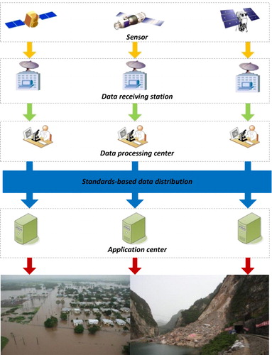
With regard to the emergency problems related to national-scale disaster management, collaboration between and integration of massive homogenous resources in disaster management applications have been extensively discussed in the literature (Hristidis et al. Citation2010; Leung et al. Citation2012; Ozguven and Ozbay Citation2013; Rao, Eisenberg, and Schmitt Citation2007). Disaster management often requires a complicated iterative process that includes disaster monitoring, early detection, forecasting, prevention, controlling efforts, loss assessment, and efficient analyses of disaster reduction (Hristidis et al. Citation2010). Each task demands not only heterogeneous data and models but also typically involves multiple disaster-related resources, such as Geographic Information System (GIS)/Remote Sensing (RS) systems, software packages, sensors, other hardware infrastructure, and even a multitude of experts, including technologists, geoscientists, RS specialists, and decision makers. In a disaster management scenario, multidisciplinary experts use related resources to collect, store, manage, organize, and process GIS/RS data and use disaster simulations and elevation models to produce meaningful information for decision makers. Therefore, it is necessary to construct a new disaster management mechanism, which foregoes centralized, isolated solutions and instead supports remote communications, distributed processing capabilities, and other necessary ingredients to successful collaborative and multidisciplinary tasks. However, most existing disaster management systems operate in a typical passive data-centric mode (as shown in ). Data-centric disaster management systems were designed and implemented by a software house for their specific purposes, and these systems often will not fit the needs of the actual disaster management tasks of other user communities. Therefore, resources cannot be fully utilized (Demir and Krajewski Citation2013; Zhishan et al. Citation2012). This impediment is being partially addressed by the increasingly complex application requirements, as well as by the growing availability of diverse resources, including observation data sources, models, geo-tools, software, sensors, and highly efficient hardware resources. Such issues exist across many geosciences disciplines (environmental studies, climatology, RS, geomorphology, etc.), each of which has multiple models, data resources, and protocols from which to choose (Huang, Maidment, and Tian Citation2011). From a technological point of view, this makes it very challenging for decision makers and other participants to bring together various resources to obtain relevant disaster information and ultimately to fulfill various disaster management applications. In practice, trivial and time-consuming operations to integrate various resources have cost most the manual resources rather than improving the decision making (Laniak et al. Citation2013). This is why most existing disaster management systems have been of limited use until now (Leskens et al. Citation2014). The detailed analysis of the shortcomings of the data-centric disaster management mode will be described in Section 2.
Aiming to minimize these shortcomings, a new integrated service paradigm, which could provide better support for scheduling and allocating relevant resources to fulfill the increasingly complex application requirements, has garnered the interest of decision makers and other participants. Such capabilities are highly desirable in situations where disaster management procedures are difficult to perform and in the critical rescuing period after experiencing a disaster. With a similar concept, the Free and Open Source Software projects (Lakhani and Von Hippel Citation2003; Lakhani and Wolf Citation2005) have been constructed with the similar goal. These projects allow users to more freely choose and mix free and open-source software tools that best fulfill their own requirements. Meanwhile, researchers in environmental management fields have proposed the use of newly developed information technologies to achieve more collaborative, open, flexible, and extendable Integrated Environmental Modeling systems (Laniak et al. Citation2013). The researchers emphasize the critical necessity of resource reuse and collaboration by means of structuring applications as a set of connected services in an integrated one-stop service system. Addressing these problems will require a coordinated effort from multidisciplinary researchers. However, there are still great challenges for the geosciences community to overcome.
This paper focuses on the critical issues associated with the geoscience disciplines, including integrated architectural styles and collaborative active service mechanisms. To overcome the shortcomings of a centralized, isolated, passive data-centric disaster information service mode, we propose a novel Focusing Service Mechanism (FSM), which is capable of scheduling and allocating multiple resources to dynamically generate collaborative and on-demand disaster information services in a holistic way. We also demonstrate the implementation of the Integrated Disaster Information Service System (IDISS), which is based on a service-oriented approach. We focus specifically on how to convert the existing heterogeneous and distributed disaster-related resources into services. Through the seamless integration, collaboration, and reuse of existing disaster resources (including data, models, geo-tools, software packages, monitoring sensors and mobile terminals, and other hardware infrastructure), the IDISS could provide on-demand services for stakeholders from multiple levels (e.g., decision makers, technicians, the public, and the staff at a disaster site) to perform their disaster management tasks in a holistic and focusing service mode.
The remainder of this paper is organized as follows. In Section 2, we briefly introduce the background and context of the IDISS research project. Then, the construction of the system is presented in detail in Section 3. Examples of the application and performance of the proposed system are provided in Section 4. Finally, concluding remarks are provided in Section 5.
2. Background
Disaster management organizations in China are facing urgent requirements to reuse and integrate existing resources. The National Disaster Reduction Application System (DRAS) of China was established by the National Disaster Reduction Center of China (NDRCC) between 2002 and 2008. In the past several years, the DRAS has been the most important disaster management tool and has been widely used to provide spatial technical support for disaster management applications. It is composed of eight subsystems and one support platform (Fan, Wang, and Yang Citation2008). Due to the complexity of the disaster information system itself and the limitations of administration and technology at the time of constructing the disaster management system, the DRAS operates under a typical top-down data-centric style. The subsystems have limited compatibility. Furthermore, it can hardly meet the increasingly complex application requirements and the growing availability of diverse resources. Based on numerous first-hand materials from national decision makers and the requirements from government reports, certain critical problems in the data-centric DRAS are summarized below.
(1) Lack of accessibility and interoperability of disaster resources
Operating in a data-centric mode (), existing disaster information systems have limited capabilities for integrating distributed resources. This is a problem not only for China but around the world, e.g., UK Environment Agency Flood Warnings, United States Geological Survey – Flood Information (https://water.usgs.gov/floods/), and the National Oceanic and Atmospheric Administration – River Flood Outlook (http://www.hpc.ncep.noaa.gov/nationalfloodoutlook/). Various disaster information resources are distributed in heterogeneous and autonomous information systems, making the sharing and interoperability of data and services very difficult, thus forming ‘information islands’, ‘data islands’, and ‘system islands’. It seems probable that inefficiently analyzing these disparate datasets (often with several tools and information systems or even manually) may lead to incomplete and inaccurate results, as well as consuming an inordinate amount of time. The problem may become worse because of the large quantity and heterogeneity of the data sources that potentially meet the simulation/assessment model requirements. Furthermore, these systems do not support the integration of real-time observation data on the conditions resulting from a disaster and typically focus on the distilling of information into action checklists.
(2) Lack of an active disaster information service
Currently, disaster management processes in China mainly work under closed, passive, static, and centralized desktop solutions. Investigations of the state-of-the-art disaster information services and management show that several key requirements for disaster management are still unsatisfied, including information integration, resource sharing, resource reuse, efficient disaster information management, dynamic observation integration and management, and adaptive and active on-demand services. Under such systems, disaster-related data and information within and between multilevel organizations cannot be communicated upstream and downstream in real time. Moreover, the passive distribution of disaster information makes it difficult to offer direct support for emergency response units, leading to a bottleneck in the imbalanced data supply and demand. Along with the increasing platform functions, processing terminals, and in situ collection terminals, the inability to share and collaborate on distinct information is becoming more obvious, thus making it difficult to meet the high-speed, high-precision, and high-efficiency requirements of integrated disaster reduction applications.
(3) Lack of the capability to fully exploit the Chinese domestically produced high-resolution RS data
At present, countries around the world are competing to develop and launch high-resolution commercial RS satellites. In China, civil satellites have performed climate, ocean, resources, and disaster reduction studies. Compared with the increasingly accessible and massive high-resolution RS data, China's existing technologies and capacities of processing high-resolution RS data cannot meet the urgent needs for disaster reduction. This fact is mainly reflected in the low capacity to rapidly process images and the low degree of automation, intelligence, and integration of the professional models used to monitor and evaluate disasters. There is still a long way to go for the Chinese domestic high-resolution RS data to achieve industrialization, marketization, and large-scale application, judging from their data quality, processing capacity, and service quality. The domestic high-resolution RS data are not yet fully utilized in the fields of monitoring and evaluation of emergencies and natural disasters.
To resolve the problems in actual applications of the DRAS and to keep up with the latest trends in collaborative science, the NDRCC, Wuhan University, along with other relevant companies and departments, conducted joint feasibility studies and proposed the conception and construction of the ‘Integrated Disaster Information Service System (IDISS)’ in 2012. The project aims to provide a new disaster management paradigm that shifts from a static data-centric mode toward the FSM-based integrated disaster management system. This system could be able to provide on-demand disaster information services for multilevel users handling various disaster management tasks in a holistic way. However, the implementations of the models and geo-functions that involve disaster management operations (including early detection, forecasting [Ding et al. Citation2013], loss assessment and efficient analysis of disaster reduction, and Geospatial data processing [Hu et al. Citation2014]) have not been discussed in detail in this paper.
3. System design
3.1. Focusing service mechanism
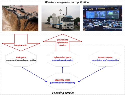
A key task in geospatial service research is to obtain and send the ‘Right data/information’ to the ‘Right person’ at the ‘Right time’ and the ‘Right place’, namely, an active on-demand service. As mentioned before, most geospatial services operate in a passive data-centric mode. To improve the efficiency of disaster information services, the FSM can be split into three main steps (). First, driven by the requests of multilevel end users, the diverse task requests will be dissolved and aggregated into the abstract, normalized task space through semantic understandings. Second, the multisource heterogeneous resources will be described and organized in the normalized resource space. After this step, the multisource heterogeneous resources will be represented as distributed geospatial services. Third, the focusing service chain will be dynamically generated by automatically matching and mapping the task space and resource space into a quantifiable capacity space, where the resources are self-organized. The focusing service chain provides a composition mechanism in the resource space to represent complex tasks as a set of scientific workflows consisting internally of integrated chains of distributed geospatial services. In these three steps, the information space for the corresponding disaster management tasks will be gained by orchestrating the focusing service chains.
demonstrates the FSM for the IDISS. The focusing service chains will be dynamically aggregated from stable sets of fine-grained services, which can best fulfill actual user needs for various disaster management tasks. These fine-grained services are generated from the resource space and include Data Service, Processing Service, Transport Service, and Sensor Service. To support focusing services, three service modes have been defined: Direct Mode, Composite Mode, and Collaborative Mode. In the Direct Mode, following the search and discovery of data from the existing data resources (including real-time observational data from in situ sensors), the data resources that meet the corresponding task demands will be directly published to end users based on the SuperMap iServer 7C, the Open Geospatial Consortium (OGC) Web Map Service (WMS), the OGC Web Feature Service (WFS), and the OGC Web Coverage Service (WCS). lists some general services and interfaces used in our project. In the Composite Mode, part of these basic services, including Data Service, Processing Service, and Transport Service, will be dynamically organized into focusing service chains. In the Collaborative Mode, Data Service, Processing Service, and Transport Service will be adaptively organized into focusing service chains. Through the self-organizing structure of the Sensor Service, the Data Service, Processing Service, and Transport Service will be focused to obtain the on-demand information by online collaborative processing.
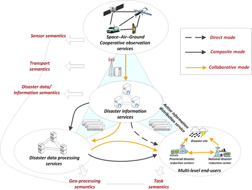
Table 1. Services and interfaces used in the IDISS.
3.2. System architecture
The IDISS has four major characteristics: perception, interconnection, intelligence, and collaboration. Its fundamental goal is to achieve the acquisition (perception), interconnection (integration), and collaboration (intelligence and collaboration) of various types of disaster resources. Its ultimate purpose is to provide multiple levels of disaster reduction and prevention departments with more integrated and more efficient applications and services through the integration of elements, the transformation of achievements, and the technical integration of existing assets.
Recent developments in Service-Oriented Architectures (SOA), virtualization, and Internet technologies allow the migration of existing resources from dedicated desktop systems to a holistic open-architecture service system (Crawford et al. Citation2005; Weiser and Zipf Citation2007). The SOA of resource integration and collaboration are attracting attention because they can address large scientific challenges in disaster management by providing integrated multidisciplinary systems that combine disaster data acquisition, management, visualization, analysis, and information communication capabilities (Droegemeier et al. Citation2005; Rao, Eisenberg, and Schmitt Citation2007). The major benefit of adopting the SOA paradigm for disaster management is that multidisciplinary disaster-related resources can be simultaneously integrated and reused as services (Magedanz, Blum, and Dutkowski Citation2007). As the basic building blocks in an SOA environment, a service includes two main components: an interface and an implementation. The service interface represents the service's functional capabilities. The service implementation corresponds to the actual implementation of the service interface. Because the interface is fixed and segregated from the implementation, multiple complex and heterogeneous resources can be easily integrated into the disaster management system by implementing and executing each service in the demanding platform environment by representing the functionality through service interfaces. Essentially, the distributed business processes and applications for disaster management that correspond to higher level composite services and applications could be much easier to construct based on the composition and integration of the services (Erl Citation2008).
In terms of adopting the SOA for constructing the IDISS, several important and challenging points to bear in mind include the increased size and load in terms of users, services, granularity, distribution, and dynamicity, which often slow down the development progress of SOA-based systems (Luo, Goldshlager, and Zhang Citation2005). To solve this dilemma, some best practices have been established to describe tangible solutions for SOA implementations (Keen et al. Citation2004; Krafzig, Banke, and Slama Citation2005). The Enterprise Service Bus (ESB), which is based on the principles of service orientation, is very helpful in realizing SOAs and is aptly mentioned as the backbone of the SOA. The ESB is a standards-based, SOA that exploits web services, XML, messaging middleware, intelligent routing, and transformation to reliably connect and coordinate application interactions. Based on the above rationale, the ESB has been adopted in this research for the construction of the IDISS. Transport services, event services, and mediation services are provided through the ESB.
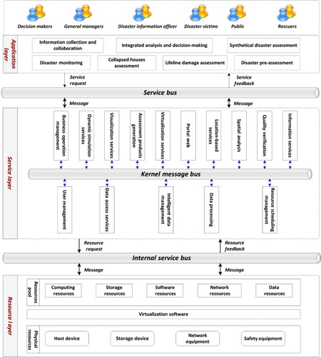
illustrates the service-oriented, ESB-based architecture of the IDISS. Through the key steps of Hardware Resources Virtualizing, Data Resources Integrating, and Software Resources Wrapping, the existing assets in the NDRCC have been made into services, and Integrated Applications have been generated by intelligent services aggregation. To embrace all the required geospatial or GIS-like functionalities, these services in the IDISS have been classified into three layers according to functionality, i.e., the Resource Layer, the Service Layer, and the Application Layer. These generated services with similar functional goals (in other words, what the service does in terms of capabilities) will be distributed and managed in the corresponding layer. Essentially, the client applications access distributed geospatial data and computing resources through services in the middleware layer. Terminal applications can rely technologically on resources and services in the Resource Layer and Service Layer to provide increased distributed hardware capacity and functions for handling huge datasets. Conceptually, the distributed GIS approach to SOA-based applications is perhaps best represented by this paradigm, in which standardized interfaces are the key to allowing geospatial services to communicate with each other in an interoperable manner that responds to the true needs of users.
3.3. Implementation
3.3.1. Resource layer
The Resource Layer lies at the bottom of the IDISS and is the ‘Infrastructure as a Service’ layer. Aiming to satisfy requirements of the upper Service Layer and Application Layer, the Resource Layer is concerned with sharing of legacy hardware and dataset resources and is also responsible for providing mandatory protocols that negotiate access to the available resources. These resources mainly include host devices, network devices, storage devices, security equipment, basic virtualization software packages, and distributed databases. To provide a clean, manageable set of bus-level services independent of the actual implementations, the Resource Layer is further divided into three sub-layers: Physical Resources, Virtualization Software, and the Resource Pool Layer, as shown in . The Physical Resources sub-layer gathers all the existing physical hardware devices and describes the state of these physical resources. The Virtualization Software sub-layer mainly provides physical resources abstraction and software resources virtualization between different operating systems and physical resources. Virtualizing is a key part of the implementation of the Resource Layer. Once the available hardware has been identified, we proceed to implement the Resource Layer by virtualizing the hardware. The Virtualization Software in the IDISS is VMware, which provides cloud and virtualization software and services. Following the abstraction of existing hardware devices and virtualization of legacy software resources, the abstracted and virtualized resources will be listed as services in the Resource Pool sub-layer, making the resource sharing and reuse among different enterprises a real possibility. The Resource Pool sub-layer is a physically distributed, logically unified, and interconnected resource center, which supports resource ‘co-operation and sharing’ and is responsible for realizing functionalities of the resource services.
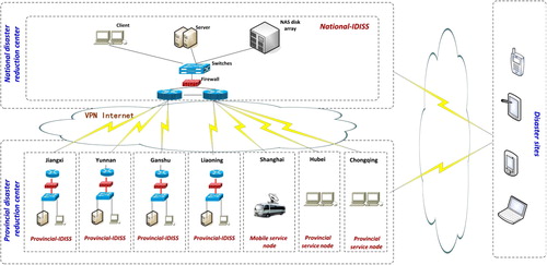
demonstrates the basic implementation architecture of the Resource Layer in the IDISS. The legacy resources of both national and provincial disaster reduction centers in China are connected through high-speed networks. As shown in , the legacy resources in the IDISS are composed of the following components:
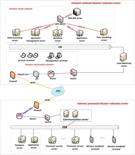
Host devices: Composed of distributed servers and workstations, including Database Server, Application Server, Storage Management Server, Operation Management Server, Communication Server, Load Balancing Server, and others.
Storage devices: Implementing data storage, backup/transfer, creating a unified resource management platform and data exchange channels between users' needs for data access/exchange and storage devices, and achieving high-speed, parallel storage services. These are composed of high-performance storage mediums and various storage networks. At the national disaster reduction centers, the storage mediums, such as SAS Disk, RAID, SAN, or NAS disk arrays, are directly connected to these servers located in the Host Devices through the Host/Backup SAN Switch and fiber links composed SAN storage network. At the provincial disaster reduction centers, the storage devices are structured with IP SAN, which adopts fiber links and LAN to connect distributed disk arrays.
Network devices: Providing a strict physical separation between national and provincial disaster reduction network. Because the integrated information services demand high-speed transmission of massive disaster data and other information products, we adopt the high-performance LAN with a 10-Gigabit core and a Gigabit desktop to build the entire network equipment.
Virtualization software: This component unifies management and dispatching of physical devices and virtualization resources to achieve the lifecycle management of virtualized resources and realizes automated deployment of virtual machines, elastic capacity of virtual machines, and monitoring of resource status. Through the virtualization of Storage Devices, Server Devices, desktop, and distributed datasets, resources such as Software Resources, Computing Resources, Storage Resources, Network Resources, and Dataset Resources can be added to the Resource Layer of the IDISS (at the bottom of ).
As shown in , to ensure the internal security from network attacks and illegal operations, the system physically separates the Internet and Intranet-based applications on the NetGap technology. The servers of the provincial disaster reduction centers in the Internet server zone can access distributed resources in the Intranet server zone of the national disaster reduction center through the Communication Server. The Internet server zone includes two servers: the Database Server and the Application Server. VMware ESXi 5.0 has been deployed in the Application Server to create virtual hosts for the provincial disaster reduction centers. Different applications according to end users' needs will be installed in the virtual host. The Intranet consists of two sub-networks: the Intranet Server sub-network and the Intranet workstation sub-network. The Intranet Server sub-network links the Intranet Database Server, Application Server, Data Processing Server, and Task Scheduling Server to a Gigabit Ethernet LAN. The Intranet Management Terminal and Services Terminal of the Intranet workstation sub-network will connect to the Gigabit Ethernet LAN through switches in the office area. lists the specifications of the servers, workstations, and computer terminals of the IDISS Resources Layer.
Table 2. Hardware resources of the IDISS.
3.3.2. Service layer
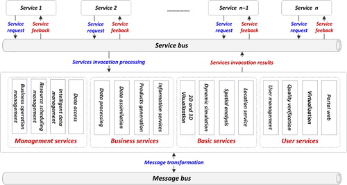
The Service Layer is the core of the IDISS and can be seen as an adjacent bridge that provides up or down links between the lower level Resource Layer and the higher level Application Layer. This layer includes service clusters logically aggregated from distributed service examples of different service types. This layer is where exposed services perform business functions through actual implementations.
As shown in , the services in the Service Layer can be classified into four major types, including Management Services, Basic Services, Business Services, and User Services. The main function of this layer is to package the services into various basic functional components (plug-ins) and then create connections between the various services with the message transmission–based ESB. This layer is the public support layer in the IDISS and is designed to provide a series of functional geo-processing services, including intelligent data management, multisource data access, processing, analyzing, visualization, and other GIS/RS operations to meet the needs of national, regional, and on-site groups. To meet the data processing and response efficiency needs of numerous subsystems in the service layer and to account for the allocation of systems and data, this layer utilizes a message bus to guarantee the communication, functionality, and data calls between the subsystems, as shown in . The functions of the Service Layer can only be called by different types of application terminals through a web browser. Under the SOA, the subsystems included in the Service Layer all consist of certain services whose reusability has been taken into consideration before system development. The services with the same goal are packed into a subsystem (blue boxes in the middle of ).
Wrapping is a significant part of the implementation of the Service Layer. Once the potential services and processes listed in have been identified and designed following the design principles, we proceed to implement all the processes by wrapping (encapsulating code in more easily readable forms) existing GIS/RS tools and software packages. In our project, we have used the SuperMap iServer 7C and OGC to wrap the existing GIS/RS tools as standard-conformant distributed services. The SuperMap iServer 7C is developed by the company SuperMap International Limited, which provides a framework for publishing and consuming our GIS/RS packages as OGC-encapsulated services, such as WMS, WFS, WCS, and WFS-T, as well as some other third-party service standards such as Bing Map and Map World. The services can be aggregated both on the client side and the server side conveniently with the SuperMap component called Service Aggregator.
3.3.3. Application layer
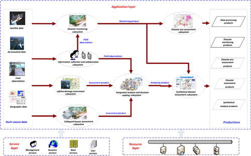
The Application Layer lies at the top of the IDISS, which directly represents the entry and access point for the composite enterprise application of multilevel end users. From the perspective of multilevel end users, the implementations of disaster management (including disaster monitoring, forecasting, prevention, resistance, control, loss assessment and efficiency analysis of disaster reduction), in terms of workflows and composed services, is the responsibility of the Application Layer. To make these business processes more efficient and effective, the IDISS provides rich, collaborative, user experiences by automatizing parts of these business workflows in the Application Layer based on the implementations of the business logic of various disaster management tasks. This layer focuses on the conception and the basic elements of workflow and builds various workflows according to the disaster management business processes. Built upon the Resource Layer and the Service Layer, the Application Layer in the IDISS clusters all basic functions through the ‘request/service portal’. This layer comprises seven subsystems that have clear functions and automated operation workflows, namely, the Disaster Monitoring Subsystem, the Collapsed Houses Assessment Subsystem, the Lifeline Damage Assessment Subsystem, the Disaster Preassessment Subsystem, the Synthetical Disaster Assessment Subsystem, the Information Collection and Collaboration Subsystem, and the Integrated Analysis and Decision-making Subsystem. Compared with other disaster management application systems or tools, one of the most significant advantages of the IDISS-based applications is that there are no mandatory requirements for any system environments, desktop GIS systems or special software packages on the client side. By simply formating and downloading the customized services through the Internet, multiple-level users can easily configure their virtual custom-designed desktops in the client machines. The customized client solutions can be lightweight and adaptively designed according to certain workflows of disaster monitoring, disaster assessment, and other disaster management applications.
The workflow among the seven subsystems in the IDISS Application Layer is shown in . With the support of the Service Layer and the Resource Layer, multiresource data will flow into different subsystems and be processed to generate various customized products. The Disaster Monitoring Sub-system will receive onsite data to create monitoring products. The Collapsed Houses Assessment Subsystem will generate house-collapse damage assessment products, and the Lifeline Damage Assessment Subsystem will generate lifeline damage assessment products. The Integrated Analysis and Decision-making Subsystem is located in the middle of the operation flow of the application platform and will generate decision-making products based on the assessment products of house-collapse damage products, lifeline damage products and field data. The Disaster Preassessment Subsystem will conduct preevaluations on the basis of monitoring products, and the comprehensive disaster assessment subsystem is located in the upper level of the operation flow of the application platform to perform integrated disaster assessments based on analysis and consultation products and field data.
3.4. Service integration and management
In addition to the Resource Layer, it should be noted that service integration and management will severely affect the communication between end users and services, which are distributed at either the Service or Application Layer. As the kernel of the Application Layer and the Service Layer, a component demonstrated in provides the proposed service integration and management solutions to handle all aspects related to service integration, including service scheduling, management, communication compatibility, service security, and quality control.
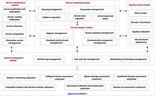
As shown in , the component is designed to provide common but necessary functions to support and handle disaster services integration and management, such as parsing of multiple standard- and protocol-based service requests, service scheduling, and composition, etc. Based on these capabilities, the IDISS could support disaster management businesses in a one-stop service manner. The modules in this component are divided into five groups, including the Service Scheduling Module, Service Management Module, Quality Control Module, System Management Module, and Service Adapter Module, which are responsible for ensuring the delivery of messages among the business processes connected via the enterprise bus. By analyzing the user registry's key and value, the System Management Module establishes a role, grants it permissions, and assigns it a user, which will be used to provide guidance on the user's right to apply and customize the service asset. After the Portal Web delegates a service request from upstream users, the Service Adapter Module will parse these requests into a standard format based on multiple standards and protocols, and the module connects to the Service Management Module. According to the normalized service requests from the adapters, the Service Management Module will search the service catalogs and then compose a logical service and pass it to a task dispatcher located in the Service Scheduling Module for routing and message-transformation work. The Service Scheduling Module will migrate the required service elements from distributed service centers. After checking the results with the Quality Control Module, the Service Scheduling Module will forward the results to the Service Management Module and finally publish the results to the end users.
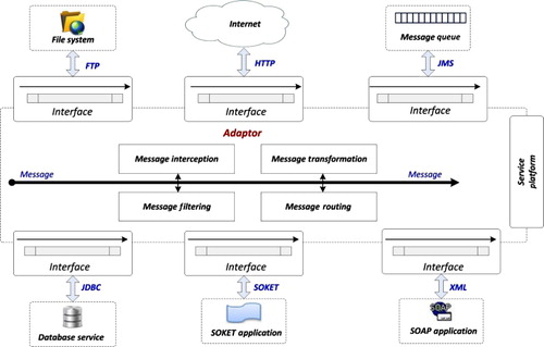
As there are a number of service codes, unified adaptors based on multiple messaging protocols (including Web Services, HTTP, FTP, SOCKET, JDBC, XML, EJB, LDAP, JMS, Email, JCA, CORBA, and RMI) have been implemented in the IDISS, as shown in , and new service interfaces can easily be added without considering the service development pattern. These adaptors can receive messages from different applications, determine the correct destination for each message type, and route the message to the appropriate destination application. Thus, service components can easily communicate among layers across the whole system according to the interoperable messaging standards.
4. Application examples and analysis
4.1. Selection of application area
With a vast area and complex natural conditions, China suffers from a wide range of frequent natural disasters in certain regions. When selecting the application area, we mainly took the following factors into consideration: the area should be a disaster-prone area, covering China's major and typical natural disaster chain; the area should have a good technical foundation, relevant technical personnel and software and hardware conditions; the area should urgently need applications that reduce the impact of disaster by using space technologies; and the application area is regionally influential.
Complying with the guidance mentioned above and based on the preceding applications of the NDRCC, seven provincial cities were selected to perform the applications and form a demonstration network system. The seven areas are divided into the following groups: comprehensive application demonstration, mobile application demonstration, and terminal application demonstration. The comprehensive application demonstration includes the disaster reduction centers of Jiangxi, Gansu, Liaoning, and Yunnan provinces and disaster information officers at county and country levels. The mobile application demonstration focuses on the disaster prevention and reduction in cities along the Yangtze River Delta, makes use of the emergency command vehicles of the Shanghai Technical Center for Disaster Prevention and Reduction, and carries out application demonstrations of space information services. Finally, the terminal application demonstration includes the Hubei Disaster Reduction Center and Chongqing Disaster Reduction Center. The systems deployment scheme is shown as .
4.2. Contents of demonstration application
To meet the requirements of disaster monitoring, disaster evaluation, and information services for disaster prevention and reduction, we have constructed an application demonstration network at the national and provincial levels in the NDRCC and seven provincial demonstration cities. Information Technologies, including high-resolution RS data processing, information service, and satellite navigation, have been integrated into the IDISS and heavily utilized in several key applications. These applications focus on disaster monitoring, disaster preassessment, damage assessment of collapsed houses, lifeline damage, integrated disaster assessment, information collection and coordination, analysis and consultation, and other demonstration areas. After the demonstration cases applied at the seven provincial disaster reduction centers, the integrated national–provincial IDISS will be officially put to use in the real disaster management works after December 2014.
In the NDRCC, the application demonstrations include making integrated use of RS data, especially high-resolution RS data, and on-site observation data to perform the application demonstrations, including disaster preassessment, damage assessments of lifelines and houses, national field information acquisition and collaboration, analysis and consultation, integrated disaster assessment, and multilevel user-oriented disaster information services. Through these demonstrations, the IDISS could make seamless connections with other existing systems in the NDRCC, including the National Disaster Information Management System, the Disaster Emergency Duty System, and other service operation systems.
In provincial demonstration cities, the application demonstration mode is divided into three categories, namely integrated application demonstration, mobile application demonstration, and terminal application demonstration. The integrated application demonstration carries out disaster monitoring, assessment, terminal information delivery collaboration, and other relevant demonstration work in four provincial disaster reduction centers: Jiangxi, Gansu, Liaoning, and Yunnan. According to the disaster characteristics and spatial information service requests of each province, the disaster monitoring, evaluation, and terminal information delivery are being conducted. The mobile application demonstration focuses on disaster reduction in the Yangtze River Delta cities and takes advantage of the emergency command vehicles of the Center of Disaster Prevention and Reduction of Shanghai to conduct spatial information service applications. The terminal application covers the Hubei and Chongqing Disaster Reduction Centers in the countryside and conducts applications, such as disaster reporting, statistics verification, and terminal spatial information services, by means of intelligent terminals and the Beidou navigation system, among others. These demonstrations at the provincial and basic levels focus on different aspects. Through these three types of application demonstrations at the province and basic levels, the performance and application modes of the IDISS will be improved. Accurate and efficient high-resolution RS applications will be promoted, and a spatial information service application network from national to regional levels will be established.
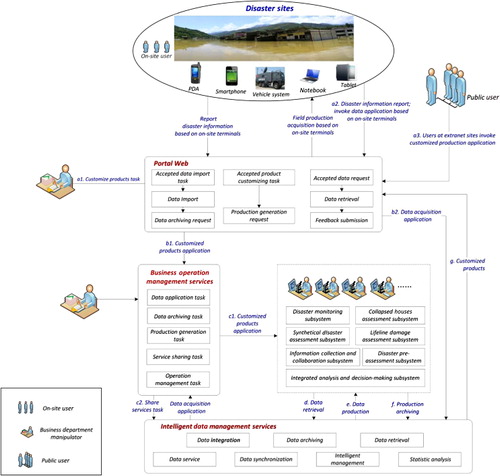
To understand the need and the scientific workflow of multiple users that include disaster sites, the public, and distributed business departments, demonstrates the use case of the IDISS. A brief description of the running process for the IDISS is listed below:
Disaster sites:
when a disaster occurs, report the on-site disaster situation based on the existing IDISS or terminals;
on-site users carry out the field observation injection tasks on PDAs or other handheld devices;
on-site users carry out the disaster information reporting tasks on PDAs or other handheld devices;
Public users: based on the services provided by IDISS, carry out the applications of customized production applications and data download tasks;
Business departments:
Carry out the specific applications according to the reported disaster information from on-site users;
On-site users and public users can invoke their disaster information applications through Web Portal;
Web Portal sends customized products applications to the Business Operation Management Module in the IDISS Service Layer;
The Business Operation Management Services decompose the customized products applications, then invoke production generation task lists to subsystems included in the IDISS Application Layer, and finally submit the service sharing tasks to the IDISS Service Platform;
The seven subsystems included in the IDISS Application Layer accept the production generation tasks and carry out the services of data retrieval and archiving;
The Service Platform carries out the service sharing tasks according to the products generated by the seven subsystems;
The Web Portal provides the generated products and data services to the public users and on-site users.
4.3. Examples of system application
Taking advantage of the existing infrastructure and data resources in the NDRCC of China, the IDISS has been built and successfully applied following the Yiliang earthquake that occurred in the Yunnan Province of China, the Gansu hail disaster, and other emergency disasters. demonstrates the real examples in the resource platform, service platform, and application platform in the system.
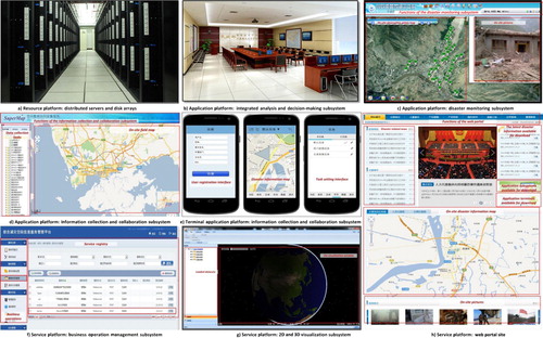
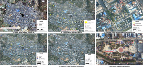
At 12:58 am, on 10 March 2013, a 5.6-magnitude earthquake struck in Yingjiang County, Dehong Dai-Jingpo Autonomous Prefecture. The depth of seismic focus was 10 km. Within the following 10 minutes, there were three local aftershocks with magnitudes of 4.7, 4.5, and 3.6. After the earthquake, the NDRCC of China launched IDISS to provide decision making and technical support, thereby starting the dimensional disaster monitoring mechanism. First, emergency observation plans for the environmental mitigation satellites (HJ-1A and HJ-1B) were urgently formulated in the NDRCC. Meanwhile, RS data from the SPOT satellite, the EROS satellite, and other RS satellite groups was actively collected by the Disaster Monitoring Sub-system. Then, the Disaster Monitoring Sub-system in the NDRCC invoked disaster site data acquisition missions to local disaster reduction centers, which quickly mobilized unmanned aerial vehicles (UAV) and PDA resources to fulfill on-site data acquisition missions. At 10 am on 11 March, the UAV took off. After the first aerial photography, 605 high-resolution images with 0.1-m ground resolution were acquired, which covered approximately 14 km2 of Yingjiang County in Yunnan Province. As soon as the data acquisition tasks were completed, the disaster site data acquired by the UAVs and PDAs were automatically pushed to the Yunnan demonstration application center. The center then made use of the high-resolution image processing service, the computing service, the storage service, and other IDISS services to make a preliminary interpretation of the high-resolution UAV images and to timely submit the data processing results to the Disaster Monitoring Sub-system in the application platform to generate monitoring products. Once the monitoring products were obtained, the Yunnan application demonstration center utilized the Collapsed Houses Assessment Subsystem and Lifeline Damage Assessment Subsystem to assess the products. Finally, the Comprehensive Analysis and Decision-making Subsystem in the NDRCC produced analysis and consultation products and an emergency displacement assistance map based on the assessment products of collapsed houses and damaged lifelines and the disaster site data submitted by the Yunnan application demonstration center. shows the IDISS-generated products for this earthquake.
5. Conclusion
In this paper, a comprehensive survey of the integration and management of geospatial information resources to serve the disaster management in China is presented. Aiming at the bottlenecks of existing disaster management system, a novel FSM-based IDISS is introduced, focusing specifically on the seamless integration, collaboration and reuse of existing disaster resources to better support stakeholders by performing disaster management applications in a holistic way. The IDISS has the following characteristics: (1) the FSM provides dynamic scheduling, allocating, and workload balancing for optimum utilization of multiple resources; (2) based on the FSM, active on-demand services for various complex tasks can be adaptively generated through the adaptive service aggregation, composition, and collaboration; and (3) through the service strategies of Virtualizing, Wrapping, and Integrating, multiple resources (including sensors, data sources, models, geo-tools, software packages, computing resources, and technologists) can be easily transformed into services to be embedded into the IDISS. Applications show that the IDISS has promoted great breakthroughs in the scientific decision-making levels of disaster management in China.
Acknowledgment
We appreciate the detailed suggestions and comments from the editor and the anonymous reviewers.
Additional information
Funding
References
- Crawford, C. H., G. P. Bate, L. Cherbakov, K. Holley, and C. Tsocanos. 2005. “Toward an on Demand Service-oriented Architecture.” IBM Systems Journal 44 (1): 81–107. doi:10.1147/sj.441.0081.
- Demir, I., and W. F. Krajewski. 2013. “Towards an Integrated Flood Information System: Centralized Data Access, Analysis, and Visualization.” Environmental Modelling & Software 50: 77–84. doi:10.1016/j.envsoft.2013.08.009.
- Ding, Y. L., Z. Q. Du, Q. Zhu, and Y. T. Zhang. 2013. “Adaptive Water Level Correction Algorithm for Flooding Analysis.” Acta Geodaetica et Cartographica Sinica 42: 546–553.
- Droegemeier, K. K., D. Gannon, D. Reed, B. Plale, J. Alameda, T. Baltzer, K. Brewster, R. Clark, B. Domenico, and S. Graves. 2005. “Service-oriented Environments for Dynamically Interacting with Mesoscale Weather.” Computing in Science & Engineering 7 (6): 12–29. doi:10.1109/MCSE.2005.124.
- Erl, T. 2008. SOA: Principles of Service Design. Upper Saddle River, NJ: Prentice Hall.
- Fan, Y., X. Wang, and S. Yang. 2008. “The Introduction of Disaster Reduction Application System of Environment and Disaster Reduction Satellites.” Disaster Reduction in China 9: 9–11.
- Fan, Y., Q. Wen, and S. Chen. 2012. “Engineering Survey of the Environment and Disaster Monitoring and Forecasting Small Satellite Constellation.” International Journal of Digital Earth 5 (3): 217–227. doi:10.1080/17538947.2011.648540.
- Hristidis, V., S. Chen, T. Li, S. Luis, and Y. Deng. 2010. “Survey of Data Management and Analysis in Disaster Situations.” Journal of Systems and Software 83: 1701–1714. doi:10.1016/j.jss.2010.04.065.
- Hu, H., Y. Ding, Q. Zhu, B. Wu, H. Lin, Z. Du, Y. Zhang, and Y. Zhang. 2014. “An Adaptive Surface Filter for airborne Laser Scanning Point Clouds by Means of Regularization and Bending Energy.” ISPRS Journal of Photogrammetry and Remote Sensing 92: 98–111. doi:10.1016/j.isprsjprs.2014.02.014.
- Huang, M., D. R. Maidment, and Y. Tian. 2011. “Using SOA and RIAs for Water Data Discovery and Retrieval.” Environmental Modelling & Software 26: 1309–1324. doi:10.1016/j.envsoft.2011.05.008.
- Iwata, K., Y. Ito, and S. Managi. 2014. “Public and Private Mitigation for Natural Disasters in Japan.” International Journal of Disaster Risk Reduction 7: 39–50. doi:10.1016/j.ijdrr.2013.12.005.
- Keen, M., A. Acharya, S. Bishop, A. Hopkins, S. Milinski, C. Nott, R. Robinson, J. Adams, and P. Verschueren. 2004. Patterns: Implementing an SOA Using an Enterprise Service Bus, 364. New York: International Business Machines Corporation.
- Krafzig, D., K. Banke, and D. Slama. 2005. Enterprise SOA: Service-oriented Architecture Best Practices, 382. Englewood Cliffs, NJ: Prentice Hall Professional.
- Lakhani, K. R., and E. Von Hippel. 2003. “How Open Source Software Works: ‘Free’ User-to-User Assistance.” Research Policy 32: 923–943. doi:10.1016/S0048-7333(02)00095-1.
- Lakhani, K. R., and R. G. Wolf. 2005. “Why Hackers Do What They Do: Understanding Motivation and Effort in Free/Open Source Software Projects.” Perspectives on Free and Open Source Software 1: 3–22.
- Laniak, G. F., G. Olchin, J. Goodall, A. Voinov, M. Hill, P. Glynn, G. Whelan, G. Geller, N. Quinn, and M. Blind. 2013. “Integrated Environmental Modeling: A Vision and Roadmap for the Future.” Environmental Modelling & Software 39: 3–23. doi:10.1016/j.envsoft.2012.09.006.
- Leskens, J. G., M. Brugnach, A. Y. Hoekstra, and W. Schuurmans. 2014. “Why Are Decisions in Flood Disaster Management so Poorly Supported by Information from Flood Models?” Environmental Modelling & Software 53: 53–61. doi:10.1016/j.envsoft.2013.11.003.
- Leung, Y., M. H. Wong, K. C. Wong, W. Zhang, and K. S. Leung. 2012. “A Novel Web-based System for Tropical Cyclone Analysis and Prediction.” International Journal of Geographical Information Science 26 (1): 75–97. doi:10.1080/13658816.2011.572075.
- Luo, M., B. Goldshlager, and L. Zhang. 2005. “Designing and Implementing Enterprise Service Bus (ESB) and SOA Solutions.” 2005 IEEE International Conference on Services Computing (SCC 2005), 1–14, Orlando, FL, July 11–15.
- Magedanz, T., N. Blum, and S. Dutkowski. 2007. “Evolution of SOA Concepts in Telecommunications.” Computer 40 (11): 46–50. doi:10.1109/MC.2007.384.
- Neumayer, E., T. Plümper, F. Barthel, and G. Y. Koji. 2014. “The Political Economy of Natural Disaster Damage.” Global Environmental Change 24: 8–19. doi:10.1016/j.gloenvcha.2013.03.011.
- Ozguven, E. E., and K. Ozbay. 2013. “A Secure and Efficient Inventory Management System for Disasters.” Transportation Research Part C: Emerging Technologies 29: 171–196. doi:10.1016/j.trc.2011.08.012.
- Rao, R. R., J. Eisenberg, and T. Schmitt. 2007. Improving Disaster Management: The Role of IT in Mitigation, Preparedness, Response, and Recovery, 192. Washington, DC: National Academies Press.
- Shi, P. J. 2002. “Theory on Disaster Science and Disaster Dynamics.” Journal of Natural Disasters 11 (3): 1–9.
- Weiser, A., and A. Zipf. 2007. “Web Service Orchestration of OGC Web Services for Disaster Management.” Geomatics Solutions for Disaster Management, 239–254. Berlin: Springer Lecture Notes in Geoinformation and Cartography.
- Zhishan, Y., L. Run, W. Yanjiang, and S. Xiaoling. 2012. “The Research on Landslide Disaster Information Publishing System Based on WebGIS.” Energy Procedia 16: 1199–1205. doi:10.1016/j.egypro.2012.01.191.