
Abstract
Interpreting spatial data to derive information is a core task in the field of Geographic Information Science and Technology. A logical step following the collection of data in online repositories is to provide geoprocessing technology for analysing data online. Online geoprocessing technology can be employed for providing a specified set of tools in a theme-specific platform, documenting a model or workflow and making it widely available, automating recurring tasks or offering simple tools to a large user group. This systematic analysis of literature evaluates how much available online geoprocessing tools are being used for answering questions in specific application contexts. An initial set of articles is derived from a keyword-based search in the database Scopus. This set of articles is manually filtered to identify applications of online geoprocessing tools. The analysis of application-related articles shows that virtually all applications require further development of tools. Experts outside the spatial information science field are still underrepresented regarding the use of this technology. The required adaptation of technology for user tasks is identified as major barrier for the wide use of online geoprocessing. Further research needs to assess user tasks and how online geoprocessing can provide the required functions in a user-oriented manner.
1. Introduction
Spatial data are increasingly available in online repositories. The extraction of information from these data requires online geoprocessing and analysis functionality (Bowen et al. Citation2012). The technology for providing and analysing data online – Web services – is available since early years of 2000 (Lopez-Pellicer et al. Citation2012). A considerable body of knowledge about online geoprocessing has been established in review articles on the field (Yang et al. Citation2010; Zhao, Foerster, and Yue Citation2012) and in advanced applications (e.g. Thiebes et al. Citation2013). Online geoprocessing has strengths regarding the provision of functionality to a large user group, the automation of recurring tasks or the sharing of workflows.
The motivation to foster the development and application of online analysis functionality is part of the vision for a Digital Earth (Gore Citation1998). A Digital Earth foresees a framework that supports collaboration and exchange among natural and social scientists, policy-makers, decision-makers and the public (Craglia et al. Citation2012). Collaboration and exchange are facilitated by online processing of data rather than desktop or offline geoprocessing, because interoperation and exchange are guiding principles of online geoprocessing. Given the advantages and strengths of online geoprocessing, in the long run this technology may emerge as an alternative or complement to desktop geographic information systems (GIS) for spatial analysis.
Brauner et al. (Citation2009) differentiate two types of research in the field of geoprocessing services: research on general issues and limitations and research linked to application domains. Correspondingly, review articles on online geoprocessing and related developments focus on technological components and tools and overviews of application domains (Bernard et al. Citation2013; Granell, Schade, and Ostländer. Citation2013; Yang et al. Citation2010; Zhao, Foerster, and Yue Citation2012). This article takes a different perspective in that it looks for documentations of the use of online geoprocessing technology in application contexts. Rather than the applications and developments themselves, their use for a specific analysis or study is in the foreground. This approach highlights application types in which this technology has been successfully employed for to date.
The main contribution of the article is an overview of application types together with representative examples and the areas of expertise of authors in the field. The evaluation shows to what degree developments of online geoprocessing technology have reached users in other fields, i.e. experts and scientists, and which factors may limit the number of applications of online geoprocessing.
The methodology of this review is based on filtering results from a keyword-based search in the bibliometric database Scopus (Elsevier Citation2014). In a step-by-step procedure, the search results are narrowed from articles about the field of online geoprocessing to articles that discuss applications of online geoprocessing technology.
The systematic literature review provides an assessment of current uses of online geoprocessing. This assessment opens the view on future research required for advancing the field. A key topic for further research will be how to close the gap between experts providing the technology and experts using it.
The remainder of the paper is organised as follows: Section 2 gives a short overview on the field of online geoprocessing, its strengths, issues and application cases. Section 3 presents the methodology of the bibliometric analysis for filtering applications of online geoprocessing functionality in research. The results and discussion of the literature search are presented in Section 4. The paper concludes by highlighting future research questions that address increasing the use of online geoprocessing (Section 5).
2. Definitions and objectives: the arena of online geoprocessing
Geoprocessing refers to the manipulation of input data to generate transformed output data. Online geoprocessing is characterised by the execution of geoprocessing operations over the Web. Thereby, applications or services are supplied with input data, the operations are executed on a computing infrastructure or a server and the results provided to users or other services. The operations or chains of operations used for data manipulation can be geometrical, topological, raster operations and other spatial and non-spatial operations.
Online geoprocessing functions, technology and implementations are reviewed in articles on the geospatial cyberinfrastructure (Yang et al. Citation2010) and the geoprocessing Web (Zhao, Foerster, and Yue Citation2012). Both approaches focus on supporting users at deriving information from data through providing Web services and computing resources; a distinctive feature of the geoprocessing Web is the support of workflow modelling and documentation (Zhao, Foerster, and Yue Citation2012).
The technological approach towards offering analysis functionality is frequently service-oriented architectures (SOA; Bernard et al. Citation2013; Zhao, Foerster, and Yue Citation2012). These architectures provide data and functionality as Web services (Yang et al. Citation2010). An example is the crop progress monitoring system of the USA, which allows the integration of remote sensing data and further parameters for the regular production of crop progress maps (Yu, Yang, and Di Citation2009). The paradigm of this approach is the publish/find/bind model that connects service provider, service broker and service client. For the description of the functionality of services and their interfaces, specifications of the Open Geospatial Consortium (OGC) or the World Wide Web Consortium (W3C) can be used (Granell, Díaz, and Gould Citation2008). The OGC provides a set of interface standards for open services; the service for online geoprocessing is the Web Processing Service (WPS; Schut Citation2007). The W3C standardised the Web services description language (WSDL; W3C Citation2001), which is a standard for describing services. WSDL facilitates the binding to services (Sancho-Jiménez et al. Citation2008).
The number of OGC Web services available over the Web has been analysed by Lopez-Pellicer et al. (Citation2012). They used a Web crawler and found that the majority of Web services are Web map services (WMS) that focus on providing images of maps, followed by Web feature services (WFS), Web coverage services (WCS) and sensor observation services (SOS). Less than 1% of the available Web services were WPSs in March 2011. These results show the ‘slow adoption of technical and semantic interoperability features of the WPS specification among practitioners’ (Lopez-Pellicer et al. Citation2012, 18).
Online geoprocessing has the potential to make spatial analysis real-time, efficient and cost-effective (Kiehle Citation2006; Zhang and Tsou Citation2009). Additionally, it supports exchange and collaboration among scientists (Huang and Yi Citation2006). The following examples show when online geoprocessing has advantages over desktop-based or offline geoprocessing:
making functionality available to a large user group without requiring the users to install software [e.g. Chen et al. (Citation2012), Qiu et al. (Citation2012) and the ArcGIS Online platform of ESRI (Citation2014)];
providing up-to-date results in online GIS applications, because of on-request processing of results based on the latest data provided (Kiehle Citation2006);
leveraging computing resources of a cyberinfrastructure for highly intensive processing (Shook et al. Citation2012);
modular combination and reuse of functionality provided as services for different applications (Theisselmann, Dransch, and Haubrock Citation2009);
sharing of a developed workflow to allow application of the workflow to a different study area (e.g. Xue, Chang, and Yang Citation2011).
Central to this literature review is the question about how much the available online geoprocessing functionality is being used. The specific focus is on applications that use online geoprocessing as alternative or extension of desktop GIS for spatial analysis tasks. A systematic literature review is presented for identifying applications of online geoprocessing. Specific questions guiding the review are as follows:
How many reports on using online geoprocessing technology, and especially Web services, for spatial analysis tasks exist?
Which types of applications can be differentiated?
Who are the authors of applications using online geoprocessing? Are they spatial information scientists or experts from other fields?
3. A bibliometric analysis of literature related to the online geoprocessing
A bibliometric analysis is performed for identifying articles reporting on applications and uses of online geoprocessing functionality. The analysis starts with a keyword-based search in the indexing database Scopus (Elsevier 2014). The resulting articles are manually filtered for identifying application-related articles. This section introduces the keywords used in the search and the filtering applied.
3.1. An approach using Scopus
Scopus is an abstract and indexing database from Elsevier. Its collection of articles goes back to 1996. Scopus facilitates searching for scientific articles, creating a bibliography and analysing authorship and citations. The tool also offers analysis functionality for listing authors, countries, affiliations, topic domains, etc. of the articles resulting from a query. It covers articles from major peer-reviewed titles related to science, technology and medicine. As reported in Sullo (Citation2007), the interface is easily navigable and user friendly.
The alternative to Scopus is the database of the Web of Science by Thomson Reuters (Citation2014). The Web of Science database has a larger temporal coverage than Scopus (1900-present in Web of Science as opposed to 1996-present in Scopus), but a smaller coverage of sources (Falagas et al. Citation2008). The Web of Science has a stronger coverage of resources from arts and humanities (Falagas et al. Citation2008), which is not essential for the present study. The shorter temporal coverage of Scopus does not have an effect in the present analysis, since the time span of interest is covered completely. Both products were therefore suitable for the study presented in this article; the author chose Scopus for its intuitive interface.
Keyword-based searches retrieve articles of interest from the Scopus database by matching search words with title, abstract and keywords of the articles. We employed search for direct matches with the search term although this approach may exclude articles that spell the search terms differently. The direct search approach was necessary for assuring the use of the keywords in the right way. For example, the term ‘Web’ is far more general than ‘WMS’, which is of interest for our analysis.
A key issue in this analysis is the choice of the keywords used in the searches. Articles that do not use the specified keywords in title, abstract or keywords, will not appear in the result set even though they may have a strong thematic linkage to the topic of interest. The approach chosen to address this issue was to start with a divers list of keywords covering different concepts of online geoprocessing, products used therein and other related terms.
Web services serve as proxy for the identification of applications in the online geoprocessing field, which emphasises service-based approaches in the analysis. There are two classifications of Web services: a classification by ISO 19119 (ISO Citation2005) and by the OGC. ISO services such as the geographic processing service – spatial or the geographic workflow service do not lead to numerous results in Scopus. OGC Web services are more frequently mentioned in articles. We therefore included OGC services in the query. The choice of services follows the findings of most frequently used services in a reality-check by Lopez-Pellicer et al. (Citation2012): WMS, WFS, WCS and SOS.
lists the two sets of keywords prepared for searching Scopus. One set focuses on GIS in general and one more specifically on online geoprocessing. Both sets of keywords contain synonyms of concepts, in order to reduce the number of articles missed in the search.
Table 1. Keyword sets related to GIS and online geoprocessing.
The synonymous or related keywords in each set are linked with a logical OR operator. The two sets are then composed using the logical AND operator. The combination of terms from the two sets with a logical AND is necessary, since not all search terms are related to the spatial realm. Cyberinfrastructure or e-Science are general terms that are frequently used in non-spatial contexts. That is why a subset of articles needs to be identified that deals with GIS and concepts of the online geoprocessing in a wider sense.
Since the development of the technology related to the geoprocessing Web took place in recent years, we limit the search to the past 9 years (2005–2013). The queries therefore contain a restriction on the publication year of the articles (‘PUBYEAR > 2004’). The search considered all resources listed in Scopus and covers all document types like journal articles, conference proceedings, book chapters, etc.
3.2. Filtering articles related to applications of online geoprocessing
Brauner et al. (Citation2009) differentiate between generic research and application-oriented research related to geoprocessing. This analysis aims at highlighting yet a different category of work in the online geoprocessing field: examples of applications or uses of the technology.
The result set retrieved from the intersection of the two keyword sets in Scopus is the starting point for a manual review of resources. This manual review is directed towards identifying applications of the technology. The manual review was necessary, because capturing the semantics of how an application of a set of concepts or tools is introduced in an article is not possible with a keyword-based search only.
The filters applied to the Scopus result set in the manual review were the clear linkage to the field of online geoprocessing and the English language of the articles. Thereby, articles outside the topic of interest or articles dealing with geoprocessing, but not Web-based geoprocessing, were excluded. These filters led to a considerable reduction of the articles relevant for the context of this analysis. The remaining articles were separated into three categories: generic research, application-oriented research and applications and case studies ().
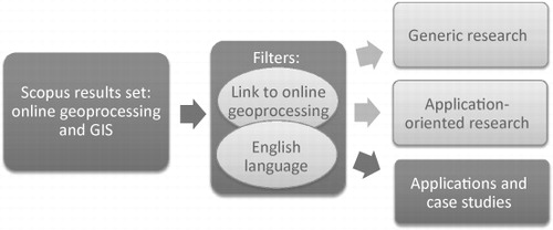
The focus was on identifying articles that describe spatial analyses or case studies using the technology of interest. Articles were attributed to this category when their main focus is on using the technology for answering a specific question and on making use of the advantages of this approach. That means that discussions of how a prototype or platform was developed does not fall into the category of articles discussing applications and case studies.
Online geoprocessing technology fulfils different purposes. These purposes range from the provision of simple GIS operations, via platforms providing processing functionality for a field of interest to general purpose GIS functionality. The investigation of uses of online geoprocessing technology showed that two main types of applications can be discerned: applications using stand-alone functionality and applications using service platforms. Stand-alone functionality includes data provision services, specific processing functionality and models as services. Service platforms can be theme-specific or general purpose. Platforms can include services for viewing catalogues, format conversion, chaining of operations, etc. as they are specified in the ISO human interaction services, workflow/task management services and geographic communication services. provides an overview on the considered application types.
Table 2. Application types separated into stand-alone functionality and service platforms.
The types of applications listed in were used to classify the identified applications and case studies. The category of ‘data provision services’ was not further analysed, because it does not deal with the analysis or processing of data that is in the focus of the article.
4. Results – a quantification of applications documented in literature
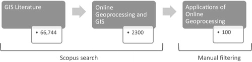
The quantitative results of the bibliometric analysis are summarised in . The Scopus search for literature related to GIS based on keyword set 1 resulted in 66,744 results on 2 January 2014. The second keyword set focusing on online geoprocessing returned 61,519 articles. The combination of the two keyword sets with a logical AND operation, resulted in 2300 articles in English language on the same date. Articles discussing case studies and uses of online geoprocessing as identified through the manual filtering, amount to about 100 articles.
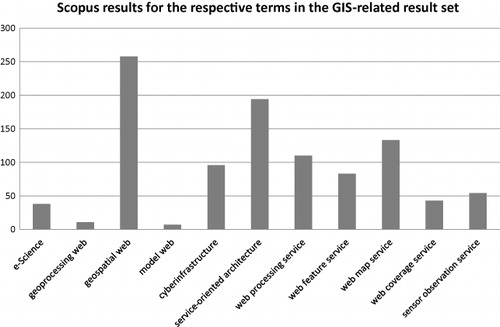
The bibliometric analysis in Scopus conveys that roughly 3% of literature in the GIS field deals with topics related to online geoprocessing. shows how terms related to online geoprocessing are represented in the GIS literature. The diagram indicates that the term geospatial Web is predominately used for referring to the organisation and presentation of spatial data on the Web (Egenhofer Citation2002; Voloder Citation2010); terms like geoprocessing Web and model Web are not widely spread by now. Looking at the mentioning of Web services in literature, the finding of Lopez-Pellicer et al. (Citation2012) is affirmed in that the WMS is the most mentioned service. Contrary to practical developments, the WPS is addressed in more articles than the WFS. The importance of SOA as stated in Bernard et al. (Citation2013) is supported by a rather large result set.
4.1. Use of online geoprocessing technology
Through manual filtering, roughly 4% (100 articles) of literature on online geoprocessing were related to applications of online geoprocessing that discusses findings related to case studies or research questions. The number of articles discussing case studies slowly increased over the past years.
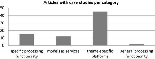
shows the amount of articles per type of application. The category standing out is theme-specific platforms. This corresponds to the large number of articles in the GIS field mentioning SOA (c.f. ), which are widely used for online geoprocessing platforms. Two further types of applications that are used similarly are specific processing functionality and specific models made available online. General purpose functionality is employed in only two articles (Kisilevich, Keim, and Rokach Citation2010; Zhao et al. Citation2011).
The area of specialisation of authors of articles discussing applications of online geoprocessing technology is of interest for answering the question whether domain experts are using this technology. The focus of the author analysis was on authors with at least three publications related to applications of online geoprocessing.
Using the author analysis tool in Scopus, the field in which authors published most of their articles was registered. The analysis shows that the authors publish predominantly in the field of computer science (58% of authors), followed by engineering (25% of authors) and environmental/earth science (17% of authors). Even though the publishing field does not indicate the background of the authors, one can assume who the target audience of the publication is as well as the level of technicality in the articles.
4.2. Representative examples for application types
4.2.1. Specific processing functionality
The category of specific processing functionality includes work on Web services that solve specific tasks or predefined workflows without being integrated in a bigger framework. Online geoprocessing functions are used among others for coordinate transformations (Sun and Yue Citation2010), quantification of river channel storage volume (Li et al. Citation2011), routing to shelters after earthquake events (Meng et al. Citation2009) and identifying forest fire hot spots (Barbosa et al. Citation2010).
The strength of chaining modular services for extended applications is widely used in online geoprocessing and discussed in Granell, Díaz, and Gould (Citation2010). Granell, Díaz, and Gould (Citation2010) discuss advantages of distributed geoprocessing and the wrapping of services for a case study of runoff in Alpine river valleys.
4.2.2. Models as services
Scientists from different fields use models for simulating the behaviour of phenomena such as landslides or groundwater flow. Online geoprocessing allows the publication of such models for providing the computing logic and results to a wider user group. Thereby, experts can test models and reproduce model results. The publishing of models as services serves the purpose of documentation as well. Articles by Feng et al. (Citation2011) and Trilles et al. (Citation2013) show the use of WPS for documenting (interdisciplinary) models.
Models for landslide analysis have been intensively studied together with online geoprocessing technology. Cannata et al. (Citation2012) use WPS for shallow landslide assessment in a real-time application. Thiebes et al. (Citation2013) provide a model for landslide analysis as WPS. The objective is the integration of this model in landslide early warning systems. The issue of preparing a set of input data is specifically highlighted and solved by the focus on a particular study area.
Dubois et al. (Citation2013) present the e-Habitat application that allows the delineation of ecological habitats for species of interest. The model implemented as WPS can be combined with climate change scenarios to allow evaluating future conditions in ecosystems. The service is open for data selected by the users, which exemplifies the wide applicability of Web services and the importance of data integration capabilities.
4.2.3. Theme-specific platforms
The majority of online geoprocessing functionality is developed in the context of theme-specific platforms, which frequently follow the SOA approach. Fields using these platforms are dealing with earthquake disaster response (Wang et al. Citation2012), farming (Chen et al. Citation2009), health and disease spread (Dominkovics et al. Citation2011; Gao et al. Citation2009) and other phenomena. Theisselmann, Dransch, and Haubrock (Citation2009) use the SOA approach for integrating models for dike breach simulation with data integration and visualisation services.
The establishment of a platform can also originate from the necessity to analyse specific data like data collected through sensors in real time (Zheng et al. Citation2012). Yu, Yang, and Di (Citation2009) describe a crop progress monitoring system that integrates sensor observations, remote sensing data and processing functionality based on Web services. Here, online geoprocessing technology supports the automatic retrieval and analysis of collected sensor data.
Dominkovics et al. (Citation2011) support the analysis of tuberculosis cases in Barcelona, Spain with density maps that are produced with Web-based geospatial services. The users can filter and analyse the data presented in maps by counting cases falling into a specified region or using operations like a buffer for the analysis of the data. This representative example shows that the functionality of the platform is adjusted to the specific tasks users in a field have. The advantage of using Web-based tools regards the implementation and delivery of the services and the flexibility in the computation of results from user-specified input data.
Helly et al. (Citation2011) describe the establishment of a geospatial cyberinfrastructure for characterising meltwater fields around icebergs. The collection of a variety of data in the cyberinfrastructure improved analysis capabilities across spatial scales. The required integration of data and the documentation of provenance received particular attention. This example shows that pooling of data and analysis functionality can facilitate research but requires at the same time the transfer of knowledge from the geospatial to other application domains.
4.2.4. General processing functionality
There are several tools that provide online geoprocessing functionality including data repositories, analysis functionality and modelling tools with the goal to support online spatial analysis: e.g. GeoBrain (Di Citation2004; Qiu et al. Citation2012), GeoPW (Yue et al. Citation2010) and the CyberGIS tool (Wang Citation2010; Wang et al. Citation2013). These general purpose environments can be based on a SOA approach as theme-specific platforms. The difference lies in the breadth of functionality provided, which is not dedicated to the analysis of specific data and themes.
Kisilevich, Keim, and Rokach (Citation2010) present a framework for spatio-temporal analysis with pluggable components in Google Earth – GEO SPAtio-temporal Data Exploration. They use their tool for evaluating sequences of visited locations in touristic trips. The motivation for their research is to reduce the re-implementation of functions using different systems through the establishment of a modular environment. Modular approaches to the provision and combination of functions are generally used in generic geoprocessing platforms.
An article by Shook et al. (Citation2012) highlights the use of a CyberGIS platform (Wang Citation2010) for accessing spatial analysis functionality together with high-performance computing (HPC) resources. These HPC resources were required for managing the analysis of the large amount of text data. The authors create emotional heatmaps of certain topics like armed conflicts based on entries in the English Wikipedia for 2003. These maps represent the tone or emotions as extracted from text documents. For providing interpolated maps of emotions, spatial analysis operations like inverse distance weighting and kernel density estimation are employed.
As seen in the example above, online geoprocessing functionality can include grid and cloud computing resources. Shi and Nellis (Citation2013) discuss the importance of HPC for geoprocessing services due to the complexity and demand for resources of these services. A review of the application of cloud computing for the field of a Digital Earth is provided by Yang, Xu, and Nebert (Citation2013). They review technological advances facilitating cloud computing, recent work in the field and open research questions.
4.3. Discussion
The main objective of this analysis was a quantification of articles demonstrating the use of online geoprocessing technology. Roughly 100 articles present applications of online geoprocessing technology according to the bibliometric analysis in Scopus. These articles generally report on case studies following the presentation of newly developed tools. In fact, the identified applications all required the adaptation or introduction of tools. This indicates that the technological framework has not yet been completely established. However, the complexity of the case studies shows that the technology is powerful, usable and has advantages for its users. The article by Shook et al. (Citation2012) even presented a research project using the CyberGIS platform. The use of the CyberGIS platform was necessary to address a research problem.
For gaining understanding of different application contexts of online geoprocessing technology, the applications were categorised into application types. These application types are stand-alone functionality and service platforms. Stand-alone functionality stands for data provision services, specific processing services or models as services; service platforms are either theme-specific or general purpose. Theme-specific platforms are the most frequently used application type; they bundle functionality that is of use for tasks of a specified user group.
The author analysis indicated that authors working on applications of online geoprocessing have their primary field of expertise in computer science. Experts from application domains seem not to have embraced this new set of tools yet. This is supported by Schade et al. (Citation2012), who mention that desktop GIS is still widely used despite the availability of online geoprocessing. Reasons may be a lack of skills and expertise in dealing with online geoprocessing technology. With respect to spatial cyberinfrastructures, Poore (Citation2011) argues that users, scientists as well as non-professional users, need to adopt infrastructures by becoming part of a community. As mentioned in Friis-Christensen et al. (Citation2007), adopting a new paradigm like SOA demands related competencies. Since using online geoprocessing technology requires adaptations to be made, non-technology centred users are disadvantaged. Yang et al. (Citation2011) directly express that scientists may use services for research purposes, but may require the collaboration with system administrators and developers for accomplishing their goals.
Successful examples of uses of online geoprocessing tools had a clear view on why this technology shall be used: for example, Shook et al. (Citation2012) required computational resources they could access in that way; Cannata et al. (Citation2012) aimed at linking two land slide models; and Helly et al. (Citation2011) required the controlled integration of diverse and large amounts of data. In a series of reviewed articles, the reasons stated for using online geoprocessing technology were rather general. Objectives were to increase interoperability and support collaboration. A critical discussion to what extent these objectives have been reached was often missing. Issues that were mentioned include the difficulty to decide on the granularity of components of workflows (Dubois et al. Citation2013); difficulties to accept data sources provided by users instead of locally managed sources (Bowen et al. Citation2012); the size of files and security issues related to data provided online (Qiu et al. Citation2012). The research agenda developed by Brauner et al. (Citation2009) referring to issues of orchestration, semantic descriptions and improved performance is still valid.
A major critique of the bibliometric analysis applied is that not all uses of online geoprocessing technology are documented in literature. The interpretation of information provided on theme-specific platforms may not necessarily be conducted from a researcher’s point of view and therefore not be reported in articles. An analysis of literature can therefore only capture works with a scientific background.
The literature analysis was based on the Scopus database. Scopus and the alternative database of the Web of Science were assessed as equally suited for the analysis after a discussion of their general characteristics (Section 3). However, it was not analysed in detail whether searching only one database leads to a bias in the results.
The review of uses of online geoprocessing technology provided had a strong focus on Web service-based approaches. This focus is expressed by the keywords used in the searches. Despite the fact that examples using other technology than OGC Web services have been identified in the review, the majority of literature analysed is related to OGC Web services. This focus limits the generality of the conclusions made to the overall field of online geoprocessing.
The differentiation of application types was empirically derived during the review of articles. The differentiation between the two types of platforms – theme-specific and general purpose – is obvious. However, the assignment of articles to the classes of specific processing services and models as services as opposed to theme-specific platforms was not always clear. For example, when models are provided, they are frequently accompanied by additional services. This results in theme-specific platform that include models. For a deeper insight into application types, an extended study on the technical and contextual background behind the provided services would be necessary.
5. Conclusions and future work
Online geoprocessing technology is successfully employed for spatial analyses and case studies as a number of articles demonstrates. Having a clear vision of the added value and having the required resources available supports the successful application (cf., Helly et al. Citation2011; Shook et al. Citation2012). Yet, the use of this technology requires further developments and adaptations through users. Additionally, the discussion of open issues shows that further developments of the technology in terms of performance, service granularity and composition, and security are necessary (Dadi and Di Citation2009; Lopez-Pellicer et al. Citation2012).
The fact that the field of online geoprocessing is still evolving, poses challenges to potential users. A set of actions may help to increase the use of the technology:
Provide demonstrations of the added value of the technology: best practice examples can contribute to the capacity and community building involved in the adoption of new technology (Friis-Christensen et al. Citation2007; Poore Citation2011).
Reduce entry and access barriers to the set of functionality: learning a new technology can be supported by demonstrations of solutions such as how to share workflows (De Jesus et al. Citation2012) as well as sharing experiences and know-how in workshops and similar forums.
Establish platforms and provide resources for online geoprocessing: for example, Lawrence, Finholt, and Kim (Citation2007) state the necessity of cyberinfrastructures to be maintained by collaborators in case they are not managed centrally by an organisation. Initiatives like the interoperability test-bed for research in geosciences address this issue and aim at providing a continuously available online geoprocessing platform (Jackson et al. Citation2011).
Advance sharing of services across platforms: the pooling of components and services developed on different platforms is limited and an open issue. Pooling of functionality would lead to establishing a base of services available for analyses and help shaping a user community.
Acknowledgements
The author thanks anonymous reviewers and colleagues from the University of Salzburg for critical comments and feedback as well as the Department of Geoinformatics of the University of Salzburg for supporting the open access publication of this article.
References
- Barbosa, M. R., J. C. S. Seoane, M. G. Buratto, L. S. O. Dias, J. P. C. Raivel, and F. L. Martins. 2010. “Forest Fire Alert System: A Geo Web GIS Prioritization Model Considering Land Susceptibility and Hotspots - A Case Study in the Carajás National Forest, Brazilian Amazon”. International Journal of Geographical Information Science 24: 873–901.doi:10.1080/13658810903194264.
- Bernard, L., S. Mäs, M. Müller, C. Henzen, and J. Brauner. 2013. “Scientific Geodata Infrastructures: Challenges, Approaches and Directions.” International Journal of Digital Earth 7 (7): 613–633.
- Bowen, G. J., J. B. West, L. Zhao, G. Takahashi, C. Miller, and T. Zhang. 2012. “Cyberinfrastructure for Isotope Analysis and Modeling.” EOS 93 (19): 185–187. doi:10.1029/2012EO190002.
- Brauner, J., T. Foerster, B. Schaeffer, and B. Baranski. 2009. “Towards a Research Agenda for Geoprocessing Services.” Paper presented at the 12th AGILE International Conference on Geographic Information Science, Leibniz University Hannover, Germany, June 2–5.
- Cannata, M., M. E. Molinari, T. Xuan Luan, and N. Hung Long. 2012. “Web Processing Services for Shallow Landslide.” International Journal of Geoinformatics 8 (1): 25–34.
- Chen, J., Y. Ren, H. Zhang, G. Liao, and K. Sun. 2012. “Oilseed Rape Productive Potentialities Assessment under OGC Web Service by Using Geoprocessing.” 1st International Conference on Agro-Geoinformatics, Agro-Geoinformatics, Shanghai, China, August 2–4, 450–455.
- Chen, T.-E., L.-P. Chen, Y. Gao, and Y. Wang. 2009. “Spatial Decision Support System for Precision Farming Based on GIS Web Service.” In Proceedings – 2009 International Forum on Information Technology and Applications, IFITA 2009, 372–376.
- Craglia, M., K. De Bie, D. Jackson, M. Pesaresi, G. Remetey-Fülöpp, C. Wang, A. Annoni, et al. 2012. “Digital Earth 2020: Towards the Vision for the Next Decade.” International Journal of Digital Earth 5 (1): 4–21. doi:10.1080/17538947.2011.638500.
- Dadi, U., and L. Di. 2009. “Creating Web Service Interfaces and Scientific Workflows Using Command Line Tools: A GRASS Example.” 17th International Conference on Geoinformatics, Geoinformatics 2009, Fairfax, Virginia, August 12–14.
- De Jesus, J., P. Walker, M. Grant, and S. Groom. 2012. “WPS Orchestration Using the Taverna Workbench: The eScience Approach.” Computers and Geosciences 47: 75–86. doi:10.1016/j.cageo.2011.11.011.
- Di, L. 2004. “Geobrain-A Web Services Based Geospatial Knowledge Building System.” Paper presented at the NASA Earth Science Technology Conference, Palo Alto, CA, June 22–24.
- Dominkovics, P., C. Granell, A. Pérez-Navarro, M. Casals,Á. Orcau, and J. A. Caylà. 2011. “Development of Spatial Density Maps Based on Geoprocessing Web Services: Application to Tuberculosis Incidence in Barcelona, Spain.” International Journal of Health Geographics 10: 1–14. doi:10.1186/1476-072X-10-62
- Dubois, G., M. Schulz, J. Skøien, L. Bastin, and S. Peedell. 2013. “EHabitat, A Multi-purpose Web Processing Service for Ecological Modeling.” Environmental Modelling and Software 41: 123–133. doi:10.1016/j.envsoft.2012.11.005.
- Egenhofer, M. J. 2002. “Toward the Semantic Geospatial Web”. In Proceedings of the 10th ACM International Symposium on Advances in Geographic Information Systems, 1–4. New York: ACM.
- Elsevier. 2014. “Scopus”. Elsevier. Accessed June 30. http://www.scopus.com/.
- Esri. 2014. “ArcGIS Online.” ESRI. Accessed June 30. http://www.esri.com/software/arcgis/arcgisonline.
- Falagas, M. E., E. I. Pitsouni, G. A. Malietzis, and G. Pappas. 2008. “Comparison of PubMed, Scopus, Web of Science, and Google Scholar: Strengths and Weaknesses.” The FASEB Journal 22: 338–342. doi:10.1096/fj.07-9492LSF
- Feng, M., S. Liu, N. H. Euliss, C. Young, and D. M. Mushet. 2011. “Prototyping an Online Wetland Ecosystem Services Model Using Open Model Sharing Standards.” Environmental Modelling and Software 26: 458–468. doi:10.1016/j.envsoft.2010.10.008.
- Friis-Christensen, A., N. Ostländer, M. Lutz, and L. Bernard. 2007. “Designing Service Architectures for Distributed Geoprocessing: Challenges and Future Directions.” Transactions in GIS 11: 799–818. doi:10.1111/j.1467-9671.2007.01075.x.
- Gao, S., E. Oldfield, D. Mioc, X. Yi, and F. Anton. 2009. “Geospatial Web Services and Applications for Infectious Disease Surveillance.” WIT Transactions on the Built Environment 110: 13–19.
- Gore, A. 1998. “The Digital Earth: Understanding Our Planet in the 21st Century.” Speech at the California Science Center, Los Angeles, California.
- Granell, C., L. Díaz, and M. Gould. 2008. “Distributed Geospatial Processing Services”. In Encyclopedia of Information Science and Technology, Information Science Reference, edited by M. Khosrow-Pour, 1186–1193. Second Edition, Hershey.
- Granell, C., L. Díaz, and M. Gould. 2010. “Service-oriented Applications for Environmental Models: Reusable Geospatial Services.” Environmental Modelling and Software 25 (2): 182–98. doi:10.1016/j.envsoft.2009.08.005.
- Granell, C., S. Schade, and N. Ostländer. 2013. “Seeing the Forest through the Trees: A Review of Integrated Environmental Modelling Tools.” Computers, Environment and Urban Systems 41: 136–150. doi:10.1016/j.compenvurbsys.2013.06.001.
- Group on Earth Observation, GEO. 2005. The Global Earth Observation System of Systems (GEOSS) 10-year Implementation Plan. Accessed September 22, 2014. https://www.earthobservations.org/documents/10-YearImplementationPlan.pdf.
- Helly, J. J., R. S. Kaufmann, M. Vernet, and G. R. Stephenson. 2011. “Spatial Characterization of the Meltwater Field from Icebergs in the Weddell Sea.” Proceedings of the National Academy of Sciences of the United States of America 108: 5492–5497. doi:10.1073/pnas.0909306108.
- Huang, B., and S. Yi. 2006. “A Geospatial Web Service Model with Application to Traffic Noise Simulation.” Geomatica 60 (1): 21–34.
- ISO. 2005. “ISO 19119: International Standard Geographic Information Services.” Oslo: ISO/TC 211 Secretariat.
- Jackson, M. J., G. Hobona, L. Bernard, J. Brauner, and C. Higgins. 2011. “The Role and Development of a Persistent Interoperability Test Bed for Geosciences Research.” Special Paper of the Geological Society of America 482: 69–75.doi: 10.1130/2011.2482(07).
- Kiehle, C. 2006. “Business Logic for Geoprocessing of Distributed Geodata.” Computers and Geosciences 32: 1746–1757. doi:10.1016/j.cageo.2006.04.002.
- Kisilevich, S., D. Keim, and L. Rokach. 2010. “Geo-Spade – a Generic Google Earth-based Framework for Analyzing and Exploring Spatio-temporal Data.” CEIS 2010 – Proceedings of the 12th International Conference on Enterprise Information Systems, 13–20, Barcelona, April 27–30.
- Lawrence, K. A., T. A. Finholt, and I.-H. Kim. 2007. “Warm Fronts and High Pressure Systems: Overcoming Geographic Dispersion in a Meteorological Cyberinfrastructure Project.” Proceedings of the Annual Hawaii International Conference on System Sciences, Waikoloa, Hawai.
- Li, X., N. Chen, W. Wang, and C. Wang. 2011. “A River Channel Storage Volume Calculation Service Based on Web Processing Service.” Proceedings – 2011 19th International Conference on Geoinformatics, Shanghai, China.
- Lopez-Pellicer, F. J., W. Rentería-Agualimpia, R. Béjar, P. R. Muro-Medrano, and F. J. Zarazaga-Soria. 2012. “Availability of the OGC Geoprocessing Standard: March 2011 Reality Check.” Computers & Geosciences 47: 13–19. doi:10.1016/j.cageo.2011.10.023.
- Meng, X., Y. Xie, F. Bian, and Z. Yang. 2009. “Finding Safe Shelters in Urban Areas for Earthquake Emergency Response through Web Processing Service.” Proceedings – 2009 International Conference on Networking and Digital Society, ICNDS 2009, Guiyang, China, 68–71.
- Müller, M., L. Bernard, and D. Kadner. 2013. “Moving Code – Sharing Geoprocessing Logic on the Web.” ISPRS Journal of Photogrammetry and Remote Sensing 83: 193–203. doi:10.1016/j.isprsjprs.2013.02.011.
- Poore, B. S. 2011. “Users as Essential Contributors to Spatial Cyberinfrastructures.” Proceedings of the National Academy of Sciences of the United States of America 108: 5510–5515. doi:10.1073/pnas.0907677108.
- Qiu, F., F. Ni, B. Chastain, H. Huang, P. Zhao, W. Han, and L. Di. 2012. “GWASS: GRASS Web Application Software System Based on the Geobrain Web Service.” Computers & Geosciences 47: 143–150. doi:10.1016/j.cageo.2012.01.023.
- Sancho-Jiménez, G., R. Béjar, M. A. Latre, and P. Muro-Medrano. 2008. “A Method to Derivate SOAP Interfaces and WSDL Metadata from the OGC Web Processing Service Mandatory Interfaces.” In Advances in Conceptual Modeling – Challenges and Opportunities, edited by I.-Y. Song, M. Piattini, Y.-P. Chen, S. Hartmann, F. Grandi, J. Trujillo, A. Opdahl, F. Ferri, P. Grifoni, M. Caschera, C. Rolland, C. Woo, C. Salinesi, E. Zimányi, C. Claramunt, F. Frasincar, G.-J. Houben, and P. Thiran, 375–384. Berlin: Springer.
- Schade, S., N. Ostländer, C. G. Canut, M. Schulz, D. Mcinerney, G. Dubois, L. Vaccari, et al. 2012. “Which Service Interfaces Fit the Model Web?” In Proceedings of GeoProcessing 2012: The Fourth International Conference on Advanced Geographic Information Systems, Applications, and Services, edited by Iaria, 1–6, January 30–February 4, Valencia, Spain, Wilmington: Publisher XPS.
- Schut, P. 2007. “Opengis Web Processing Service.” OGC Publicly Available Standard. Accessed September 22, 2014. http://www.opengeospatial.org/standards/wps.
- Shi, X., and M. D. Nellis. 2013. “Semantic Web and Service Computation in GIScience Applications: A Perspective and Prospective.” Geocarto International 29 (4): 400–417.
- Shook, E., K. Leetaru, G. Cao, A. Padmanabhan, and S. Wang. 2012. “Happy or Not: Generating Topic-based Emotional Heatmaps for Culturomics Using Cybergis.” IEEE 8th International Conference on E-Science, e-Science 2012, Chicago, IL October 8–12.
- Sullo, E. 2007. “Scopus.” Journal of the Medical Library Association 95: 367–368. doi:10.3163/1536-5050.95.3.367.
- Sun, L., and P. Yue. 2010. “Web Processing Service for Geospatial Coordinate Transformation.” 8th International Conference on Geoinformatics, Beijing, China.
- Theisselmann, F., D. Dransch, and S. Haubrock. 2009. “Service-oriented Architecture for Environmental Modelling - the Case of a Distributed Dike Breach Information System.” Proceedings of the 8th World IMACS Congress and MODSIM09 International Congress on Modelling and Simulation: Interfacing Modelling and Simulation with Mathematical and Computational Sciences, 938–944.
- Thiebes, B., R. B. Bell, T. Glade, S. Jäger, M. D. Anderson, and L. Holcombe. 2013. “A Webgis Decision-support System for Slope Stability Based on Limit-equilibrium Modelling.” Engineering Geology 158: 109–118. doi:10.1016/j.enggeo.2013.03.004.
- Thomson Reuters. 2014. “Web of Science.” Accessed June 30. http://thomsonreuters.com/web-of-science/.
- Trilles, S., P. Juan, L. Díaz, P. Arago, and J. Huerta. 2013. “Integration of Environmental Models in Spatial Data Infrastructures: A Use Case in Wildfire Risk Prediction.” IEEE Journal of Selected Topics in Applied Earth Observations and Remote Sensing, 128–138.
- Voloder, I. 2010. “Future Progress of the Geoweb.” MIPRO, 2010 Proceedings of the 33rd International Convention, 1309–1315.
- W3C. 2001. Web Services Description Language (WSDL) 1.1.
- Wang, J., M. Pierce, Y. Ma, G. Fox, A. Donnellan, J. Parker, and M. Glasscoe. 2012. “Using Service-based GIS to Support Earthquake Research and Disaster Response.” Computing in Science and Engineering 14 (5): 21–30.doi: 10.1109/MCSE.2012.61.
- Wang, S. 2010. “A Cybergis Framework for the Synthesis of Cyberinfrastructure, GIS, and Spatial Analysis.” Annals of the Association of American Geographers 100: 535–557.doi: 10.1080/00045601003791243.
- Wang, S., L. F. Anselin, B. G. Bhaduri, C. H. K. Crosby, M. F. I. Goodchild, Y. Liu, and T. L. J. Nyerges. 2013. “Cybergis Software: A Synthetic Review and Integration Roadmap.” International Journal of Geographical Information Science 27 (11): 2122–2145.
- Xue, T., Z. Chang, and R. Yang. 2011. “Location Selection of Ecological Zone Based on Geoprocessing Server.” CSDM 2011 – Proceedings 2011 IEEE International Conference on Spatial Data Mining and Geographical Knowledge Services, 540–543.
- Yang, C., M. Goodchild, Q. Huang, D. Nebert, R. Raskin, Y. Xu, M. Bambacus, and D. Fay. 2011. “Spatial Cloud Computing: How Can the Geospatial Sciences Use and Help Shape Cloud Computing?” International Journal of Digital Earth 4: 305–329.
- Yang, C., R. Raskin, M. Goodchild, and M. Gahegan. 2010. “Geospatial Cyberinfrastructure: Past, Present and Future.” Computers, Environment and Urban Systems 34: 264–277.
- Yang, C., Y. Xu, and D. Nebert. 2013. “Redefining the Possibility of Digital Earth and Geosciences with Spatial Cloud Computing.” International Journal of Digital Earth 6: 297–312. doi:10.1080/17538947.2013.769783.
- Yu, G., Z. Yang, and L. Di. 2009. “Web Service Based Architecture for US National Crop Progress Monitoring System.” International Geoscience and Remote Sensing Symposium (IGARSS), IV-789-IV-92.
- Yue, P., J. Gong, L. Di, J. Yuan, L. Sun, Z. Sun, and Q. Wang. 2010. “GeoPW: Laying Blocks for the Geospatial Processing Web.” Transactions in GIS 14: 755–772. doi:10.1111/j.1467-9671.2010.01232.x.
- Zhang, T., and M.-H. Tsou. 2009. “Developing a Grid-enabled Spatial Web Portal for Internet Giservices and Geospatial Cyberinfrastructure.” International Journal of Geographical Information Science 23: 605–630. doi:10.1080/13658810802698571.
- Zhao, L., C. X. Song, J. Lee, J. R. Kim, W. Feng, V. Merwade, and N. B. Villoria. 2011. “Bring Integrated GIS Data and Modeling Capabilities into Hubzero Platform.” Proceedings of the ACM SIGSPATIAL 2nd International Workshop on High Performance and Distributed Geographic Information Systems, ACM SIGSPATIAL HPDGIS 2011, 30–33.
- Zhao, P., T. Foerster, and P. Yue. 2012. “The Geoprocessing Web.” Computers & Geosciences 47: 3–12. doi:10.1016/j.cageo.2012.04.02.
- Zheng, Z., N. Chen, P. Li, and W. Wang. 2012. “Integration of Hydrological Observations into a Spatial Data Infrastructure under a Sensor Web Environment.” International Journal of Digital Earth 6 (2): 22–40.