
ABSTRACT
Reductionist thinking will no longer suffice to address contemporary, complex challenges that defy sectoral, national, or disciplinary boundaries. Furthermore, lessons learned from the past cannot be confidently used to predict outcomes or guide future actions. The authors propose that the confluence of a number of technology and social disruptors presents a pivotal moment in history to enable real time, accelerated, and integrated action that can adequately support a ‘future earth’ through transformational solutions. Building on more than a decade of dialogues hosted by the International Society for Digital Earth (ISDE), and evolving a briefing note presented to delegates of Pivotal 2015, the paper presents an emergent context for collectively addressing spatial information, sustainable development, and good governance through three guiding principles for enabling prosperous living in the twenty-first century. These are: (1) open data, (2) real-world context, and (3) informed visualization for decision support. The paper synthesizes an interdisciplinary dialogue to create a credible and positive future vision of collaborative and transparent action for the betterment of humanity and planet. It is intended that these Pivotal Principles can be used as an elegant framework for action toward the Digital Earth vision, across local, regional, and international communities and organizations.
1. Introduction
The international community has recognized 2015 as a pivotal year in confronting the urgent and unprecedented global issues that are defining the twenty-first century (Sachs Citation2015; The Economist Citation2015a). Indeed, UN Secretary-General, Ban Ki-Moon announced in February 2015 from Peru that ‘we are the first generation that can end poverty. We are the last generation that can avoid the world effects of climate change.’ (Ki-moon Citation2015). A number of critical international forums in 2015 targeted fundamental challenges, such as mitigating the increasing scale and scope of disasters (Sendai), financing development to meaningfully address global poverty (Addis Ababa), achieving critical yet elusive sustainable development goals (New York), and reaching agreement on addressing climate change at COP21 (Paris) (United Nations Citation2015a,Citationb,Citationc,Citationd). The scale, scope, and urgency of this complex array of global challenges are unprecedented and sharply delineate this century from previous centuries (Smith, Hargroves, and Desha Citation2010).
Alongside these challenges, an ‘informational revolution’ is taking place with emerging new and powerfully disruptive technologies that could enable a region or nation to come to grips with their current reality and shift their collective behaviors to enter onto a path for sustainability. These include big data, Earth observation, 3D visualization, sensor networks, ubiquitous smartphones, and social media amongst a growing milieu. As noted in the International Society for Digital Earth's (ISDE) Beijing Declaration (ISDE Citation2009), such disruptive elements bear increasing responsibility in the years to come to enable implementation of the overarching and ambitious international goals for humanity.
Collectively, humanity faces a suite of interconnected issues that appear to elude conventional approaches to command and control leadership style. The challenges and the opportunities have been highlighted and deliberated at previous ISDE meetings, culminating in two seminal papers by Goodchild et al. (Citation2012) and Craglia et al. (Citation2012), which define multiple opportunities in the original and updated Digital Earth vision. The themes raised in the two papers are panoramic, spanning: Digital Earth and information infrastructure, information resources for global sustainability, the global commons, sustainability, global change, and action opportunities harnessing the potential of Digital Earth.
Global leaders from backgrounds beyond information technology are concurrently beginning to recognize that addressing the confluence of these complex issues will require a fundamental shift in policy, governance, and decision-making. Indeed many of these challenges stem – at least in part – from the ways in which governance and decision-making have been conducted in the past. An emerging consensus is evident from the global dialogue that ‘the’ sustainability challenge facing any region or nation is how to optimize governance, business, and citizen engagement to improve prosperity for all (Foresman and Edwards Citation1996; Smith, Hargroves, and Desha Citation2010; Hargroves and Smith Citation2005).
Within this context, and responding to the need for urgent action, this paper further explores the meta-narrative provided by Goodchild et al. (Citation2012) and Craglia et al. (Citation2012). In a pragmatic attempt to encourage action across the broad spectrum of humanitarian and technological dimensions considered, we put forward an overarching framework to action the Digital Earth vision, comprising three synthesized ‘Pivotal Principles’ as a set of foundational enablers for development in the twenty-first century.
We have distilled these three principles from a veritable kaleidoscope of issues facing the Digital Earth community when considering big data challenges in the Earth Science field. These principles presented themselves after 12 months of literature review and communications with thought leaders from around the world including participation in the 2014 G20 event and Pivotal 2015 in Brisbane, Australia. The interdisciplinary dialogues have spanned themes of geography, spatial information analytics, engineering, and planning to create a credible and positive future vision, based on a twenty-first century reconceptualization of planetary resources. Discussions moved beyond ‘water, waste and energy’ to incorporate data and humanity as important resource dimensions that provide additional capacity to drive sustainable solutions this century.
In the following sections, the paper discusses the unprecedented scale of challenges and the need for innovative governance and decision-making to adapt and deliver the necessary transformational changes. Building on a ‘Special Brief to Delegates’ that the authors prepared for the Pivotal 2015 Summit (Foresman et al. Citation2015), we highlight the extraordinary potential to harness ‘resources’ beyond those that drove the industrial revolution (i.e. water, energy, and materials), to consider data and digitally enabled human potential to achieve transformational change for future earth. We present the three principles: facilitating access to open data; integrating real-world context; and visualizing science for community decision support. These principles provide an ethical foundation and economically viable approach for sharing data, assessing risk, and planning for a sustainable and prosperous future. While not claiming them as ‘panacea’ (i.e. cure-all) for the challenges facing the Digital Earth community, the principles do offer an elegant framework for establishing a context for action – within nations and internationally – opening up solution spaces for transformational and sustainable change in governance and decision-making in a complex and dynamic world. Contemplating the three principles, we conclude by discussing their implications for addressing twenty-first century complexities and problem solving.
2. Defining the pivotal principles
Three guiding principles, herein Pivotal Principles, provide for the collective focus by government and business leaders targeting prosperous living in the twenty-first century, namely: (1) open data, (2) real-world context, and (3) informed visualization for decision support. The spectrum of challenges currently facing Humanity (noted in Section 1) fundamentally creates a need for new models of governance and decision-making for several key reasons. Firstly, the challenges faced, including climate change, resource shortages, population growth, global inequality, and financial instability (among others) are interrelated and global in scale, yet with local ramifications and varying strategies for mitigation and adaptation (Brown Citation2009; Smith, Hargroves, and Desha Citation2010). Within this dichotomy of scale, notions of national autonomy and independence are undermined (Sassen Citation2013), as evidenced by the plethora of conferences seeking agreement on collaborative approaches to address them. Furthermore, the global scale of these challenges is such that ‘retreat’ or ‘outsourcing’ is no longer a viable strategy in the face of environmental, social, or economic collapse (Steffen et al. Citation2011). As aquifers decline globally, productive agricultural lands shrink, carbon sinks disappear and international refugee movements become a global phenomenon. It is clear from the uncontrolled humanitarian problem of Middle East and African refugees in Europe that issues must be addressed fundamentally and at source, and cannot be ignored or shifted elsewhere. These global challenges faced are also interrelated and complex, and cannot be addressed by singular discipline focus or in isolation (Beddoe et al. Citation2009).
Reductionist thinking that has been the hallmark of scientific approaches for centuries will no longer suffice to address the contemporary and complex challenges that defy sectoral, national, or disciplinary boundaries. Furthermore, many of our twenty-first century challenges and opportunities are unprecedented, such that lessons learned from the past simply cannot be used to predict outcomes or help guide actions going forward. The scale, scope, and urgency of the challenges and opportunities are also such that our global civilization needs an unparalleled level of transformational innovation, as incremental change campaigns or policies remain based on antiquated pre-existing systems, which therefore perpetuates the issues and destructive legacies inherent to those systems.
Non-government organizations have arisen as dominant players in local, national, and international governance, with some corporations producing annual profits larger than many nations’ GDP (Pingeot Citation2014), almost as many staff as the Chinese People's Liberation Army (The Economist, Citation2015c), and in some cases shipping fleets larger than nations’ navies (Sharda Citation2011). Media and the online community pervasively scrutinize and powerfully influence politics and national agendas (Esser Citation2013); governance is no longer the privy of governments and oligarchies, and as a consequence the manner in which governance is conducted must adapt.
The question arises – ‘how can Humanity excel in this situation’? We propose that there is a unique opportunity to harness the cumulative power of these digital-age resources. Specifically, we propose that empowered governance and decision-making for the immediate future will require creatively harnessing the full spectrum of resources available to us at this point in time. Expanding on the ‘environmental service’ resources modeled by the Limits to Growth (Meadows et al. Citation1972) team more than 40 years ago, the last decade has seen the emergence of two other ‘resources’ around the planet comprising ‘geo-spatial information’ resources (i.e. Digital Earth data, defined as the collective of Earth Observation, scientific monitoring, business and governance data about the planet) and digitally augmented ‘human’ resources (i.e. enabled by a communication revolution, including smartphone directed network effort and intelligence).
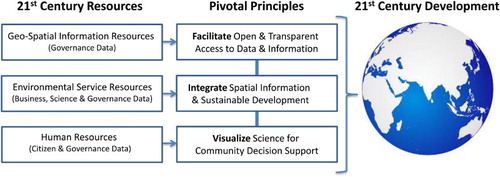
Twenty-first century development will require a systemic reboot in operations and design to address the Brundtland Commission's sustainable development goal of meeting the needs of the present without compromising the ability of future generations to meet their needs (World Commission on Sustainable Development Citation1987). As illustrated in , we propose that each of the three resource categories (i.e. geo-spatial information resources, environmental service resources, and human resources) must be engaged to implement transformational change through the appropriate Pivotal Principles. The types of data are noted in brackets in . In summary, a vast amount of publically funded data relating to governance can be used for societal benefit through ensuring open and transparent access to data and meta-information regarding the data. Seemingly unrelated business, science, and governance data have the potential to collectively address pertinent questions for humanity, through integrating spatial information with sustainable development concepts and theories. People have the potential to be important and timely contributors to previously bureaucratic and lengthy decision-making processes, through harnessing citizen data with governance data in a synthesized and visualized arena.
Figure 1. Three principles for development in the twenty-first century.
In summary, the Pivotal Principles collectively encourage a digital-age ‘operating platform’ for key sectors in society to provide a foundation for ethically sound practices globally while addressing development for the estimated 10 billion global population by mid-century. The foundation for ethical and morally sound considerations is contained within each of the principles, and addresses the needs of developing and developed countries. For example, crime and corruption is a ubiquitous human attribute, however constant monitoring and openness in government information and services is assisting in addressing, or ameliorating this universal criminal issue. By offering unprecedented access and display of budgets, roles and responsibilities, with visible links to real-world places and projects, citizens can observe for themselves the gears and wheels of government operations. With Digital Earth visibility of projects and operations, and full access to the data, citizens and oversight organizations can efficiently monitor what has been previously hidden government and business transactions. Since the early 2000s, major funding agencies, such as the World Bank, have been exploring the capacity to help monitor development projects and track the disbursement of funds with the advent of Digital Earth technologies. Opening up data access and creating highly graphic monitoring platforms have proven effective tools in digital-age campaigns to counteract the negative impacts of corruption.
3. Principle 1: Open data
This first principle refers to the capacity for open data to facilitate open and transparent access to data and information, creating protocols and procedures to access all government-derived data with notable exceptions for citizen privacy (Ubaldi Citation2013). Open data access and the transparency of such data are critically important for effective and timely decision-making. By removing bottlenecks in the flow of bureaucratic information, government staff and citizens can better track data and its origins and in turn promote more rapid consumption of data. Data when congested in departments and divisions act much like log jams in a river's bend. Only through open data flow can an organization hope to promote free flow access and improved use of data. In the past, measurement science drove the agenda, with access to data being the biggest challenge to decision-makers. Technical access is no longer an issue for many parts of the world via the internet; however, open data policies remain critical for removing the residual and inherent bureaucratic resistance to releasing information (Uhlir Citation2015).
When applied, this principle has been demonstrated around the globe to be an effective approach to unleashing economic development for a society. Indeed, the goal of open data continues to be touted, and backed with serious economic studies, as the next wave for business innovation and expansion in the digital economy (Berman Citation2013a; Deloitte Citation2012; PwC Citation2014). By applying the international regulatory environment for constructs such as the Creative Commons, a nation can unleash the innovative and economic potential of its businesses and citizens, while also significantly upgrading the capacity to utilize the government's information resources (Berman Citation2013b; Christofferson Citation2014).
A policy of transparency provides opportunities for containing corruption and eliminating waste and fraud across the range of government types. Indeed, a thousand eyes and minds can observe government better than any agency or department with the remit to investigate probity of performance. Overwhelming evidence shows the Landsat open data policy implementation of 2008 has led to an exponential increase in Earth systems and land-use change studies by the international science community. This satellite data revolution has yielded many data analytic advances. This open policy evidence presents a clarion call to other nations for harnessing our collective capacity to measure, map, and monitor our planet and its resources (Wulder and Coops Citation2014). Business and citizens working proactively and engaged with establishment of an open data policy can highlight inefficiencies of the system much better than any capacity of the free press.
This principle also addresses the ‘data rot syndrome’ where data are gathered but not fully utilized, yielding lower or no value to citizens and government alike. This is particularly pertinent when considering that data have often been obtained through costly tax-payer or shareholder expense. Using an ocean of data metaphor, data can be thought of like fish – we catch it, and then need to consume it. If the fish – or data – are left out on the bench, or treated/ stored badly the data will quickly rot! The challenge is to know what data to harvest, how to treat, how to store, and how to consume the costly data commodity. Furthermore, extending the metaphor to human resourcing, if data are like fish, we need to find people who know how to fillet, store, sell, and consume the data efficiently.
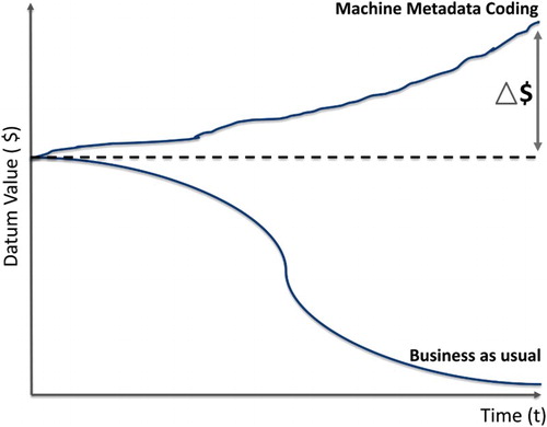
illustrates the financial impact of business-as-usual data management and the potential for smart meta-coding to improve the value and capacity for reuse of data over time. As discussed in The Guardian (Gibbs Citation2014) and as far back as 1996 (Foresman and Edwards), data lose its value under the business as usual scenario when not properly stored or tagged with metadata to enable scientific and forensic assessment of goodness of fit for the data. However, if properly tagged, either automated or manually, data can retain its value over time and be used to define change over time, thereby increasing its value (delta) for predetermined or unplanned trend analyses.
Figure 2. An illustration of the value of machine metadata coding over time.
It is imperative that organizations manage data as a living and valuable asset. Currently, most organizational data are limited in accessibility and usability, even to the departments tasked with collection and stewardship responsibility. To avoid the depreciating value of data over time, data need to be collected, collated, and managed in best practices and systematic ways (that is, ‘machine metadata’). Compliance with open data and data collection best practices can ensure data resources exist in standardized and accessible formats, with a standard format for fully describing and organizing data. Done properly, the capacity then exists for sharing files and scaling up software to store and analyze these massive volumes of valuable information. Big data techniques can further exploit and add value when volumes of data are accessible. Analytics for data, big and small, provide more valuable if metadata accompany these data. Attention from governments around the world to open data issues has created substantial interest in international best practices, which has generated multiple open-source technical automation options (UK Government Citation2013; Ubaldi Citation2013).
With these protocols in place, the data can be accessed immediately, both internally and by enterprising communities (e.g. local business for government data). Continuing the fish metaphor, immediate access ensures fresh fish useful for an information marketplace. Furthermore, as requirements to assess changes and future impacts of development actions increase, data made available now can be used as analytical and historical data sets, such that the value of this data increases over time. Hence, whilst there are costs associated with implementing machine metadata, the value of this investment will increase over time as the volume of data increases, both in terms of historical extent and diversity of datasets, enabling a greater diversity of organizations from around the world to use this data in more novel ways. Since the cost of implementing machine metadata is a per-unit item transaction, and the value over time is a multiplier for the system (as the data are used in a variety of ways), the cost-savings are significant. This also highlights the importance of smart decision support systems, to ensure that the data can be used effectively and retain their economic value to a variety of stakeholders.
A major barrier to actualizing this open data goal is a combination of political policy and bureaucratic inertia. As demonstrated by the Australian and New Zealand Foundation Spatial Data Framework (ANZLIC Citation2014), national governments can set into motion open data policies, which have unleashed unprecedented volumes of free data to the public (for example the National Map Citation2015; Queensland Globe Citation2015). Global Spatial Data Infrastructure models may stimulate the open data dialog (GSDI Citation2015) that may further encourage expansion of the open data beyond spatial. Systemic acceptance and follow through of stated open data policies can, however, take time due to mechanisms that are required within myriad government agencies for compliance. While technically, the barriers are low, the cultural of government bureaucracies can be more challenging and may require transitional budgets to gain necessary traction over the current operational inertia of business as usual. It is through the efforts of organizations like the Group on Earth Observation (GEO Citation2015), with its recent white paper on the value of open data (Uhlir Citation2015) and the Open Data Institute (ODI Citation2015) that best practices can be expanded internationally.
4. Principle 2: Real-world context
This second principle refers to the potential and the benefit to integrate spatial information and sustainable development to inform and catalyze the decoupling of economic growth from negative environmental pressure. Effectively, value lies in being able to create processes and protocols that enable time-sensitive, contextual decision-making moving from remedial and small incremental changes to proactive and transformational solutions (Smith, Hargroves, and Desha Citation2010) and shifting the focus of spatial information from data collection to questioning, analyzing, and interpreting data (Dangermond Citation2010; Goodchild Citation2010). This principle creates a decision support framework, capitalizing on the best systems engineering practices, while showing importance of spatial information to respond to targeted, strategic questioning.
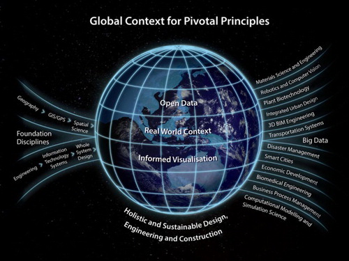
In the complex reality presented earlier, we have asked, ‘How are we defining the problems so that we can frame appropriate questions to answer, conduct analytics and make decisions that are meaningful and timely?’ As discussed over the last decade by key authors including Cash et al. (Citation2003), Coenen, Benneworth, and Truffer (Citation2012), Roche (Citation2014) and Nyerges et al. (Citation2014), solutions must be fully integrated with spatial context. The spatial sciences offer mechanisms for comprehending and analyzing complex system dynamics through locational representation, management, and modeling information. Data are now just the beginning, with the challenge shifting to the space of complex real-world context problem solving, as illustrated in . Transdisciplinary interactions by foundation disciplines spanning geography through to engineering, provide a rich environment for holistic and sustainable design, engineering and construction. Through the enabling principles of open data, real-world context and informed visualization, these practices lead to a myriad of solutions in arenas spanning materials science and engineering through to computational modeling and simulation science.
Figure 3. An illustrated ‘global context’ for the three Pivotal Principles.
Fortunately, we have at our disposal an increasing array of robust tools. The Digital Earth community is using Earth observation satellites and spatially enabled technology integrated with sustainable development oriented planning and engineering methods to enable local and regional organizations the ability to bring together the multitudes of digitally formatted data much more effectively. For example, Building Information Modeling (BIM) allows for sophisticated advance planning and cost-effective project development that attends to human dimensions for work and livable buildings and cities. BIM represents the new suite of life-cycle project engineering and planning tools that enable interdisciplinary teams to collaborate more effectively on sustainable and systems engineering projects (SIBA Citation2015). Distributed, renewable energy systems and modern transport design not only revolutionize city flow patterns for better commerce, they improve health of the citizens and reduce carbon release to the atmosphere. Importantly, such projects are proving to be the most economically viable approaches to individual buildings and communities, while at the same time improving resilience to natural hazards and the impacts of climate change (Plume et al. Citation2015; Von Weizsacker et al. Citation2009).
Such spatial science for sustainable development solutions will be fueled in part by attempts to address the US$70 trillion gap in global infrastructure investment required by 2030 (G20 Australia Citation2014). The principle is predicated on the confluence of advanced engineering models and methods for green and sustainable design and construction of buildings, transport and energy systems, incorporating the advances in spatially enabled data analytics and information systems technology. Locational attributed entities provide for significant advantages for capturing the interrelated environmental, social, and economic benefits for society. Life-cycle project management and integrated financial-project engineering methodologies are becoming standard for infrastructure investments. Locational precision and full system integration of spatially enabled components and models are proving to be the cutting edge advantage for engineering firms (Plume et al. Citation2015).
However, this principle requires more than a ‘Geo-wiz’ approach, which relies on automating old manual systems without proper investigation about what it should or could be, toward ‘Geo-wisdom’ involving engagement with citizens and their hand-held technologies. Acknowledging the power of hand-held devices to inform, and addressing the potential for rapid generation of data without purpose, we need to be systematically asking ‘do we still need that information’, ‘are we respecting the tax payers investments’, and fundamentally ‘how should we approach this problem’? We also need to further explore critical issues such as identifying and addressing gaps in data accessibility between providers and consumers, engaging end users from the beginning when proposing data system solutions, and effectively connecting multi-disciplinary research teams to deal with problems where a broad range of environmental, technical, political issues need to be investigated concurrently at regional, continental, and global levels.
Through asking real-world questions and exploring such issues, it is possible to effectively harness the vast volume of data to provide real-time insights into these systems. Furthermore, these vast data sets, or big data, can be used for future trending considerations and predictions based on recent events, rather than relying on data from climate patterns of the past. In effect, and building on the argument presented by Fuller more than 30 years ago (Foresman Citation2010; Fuller Citation1981), through the spatial sciences, governance for sustainable development can be informed, dynamic, and synergistic, accommodating changing climatic conditions and the complex interactions between environmental and behavioral phenomena.
5. Principle 3: Informed visualization
This third principle highlights the imperative to visualize information for decision support through ‘sentient visualization’, within the context of complex, dynamic, and increasingly interrelated systems today. As the central mechanics, tools, and methods become more refined over the next decade, science-based decision support for government, business, and citizens will become the next reality for addressing the big local and international challenges. In Queensland, Australia, hundreds of water utility customers engage with a Digital Earth interactive visualization of water distribution and factors affecting rates as part of the utility company's campaign to improve community decision support (Seqwater Citation2015). Citizens and utilities gain from shared visualization of complex systems.
Combined with the power of Earth observation data, a citizen anywhere in the world can view and investigate any place in the world. The personal smartphone has made an unprecedented and fundamental science-social revolution as aligned with the Digital Earth Vision. Indeed, it is through the advances in collectively viewing ‘the world that we live in’ that communities and nations obtain an objective and comprehensive perspective of the commons (Hardin Citation1968). An increasing body of knowledge is illuminating how the visual cortex processes visual information, which in turn further engages cognitive functions of our brains, thereby amplifying the impact of information (Kaku Citation2014). With the projection that 80% of the adult population worldwide will possess smartphones by 2020, a radical shift in visualizing our world, and perhaps our understanding, is just beginning. For example, the use of disruptive visualization-based, ‘Digital Earth’ technology for a myriad of daily decisions regarding location and transport decisions for individual consumer choices is underway around the globe (The Economist Citation2015b). The application of ‘Google Earth’ and other smartphone application searches have become commonplace for all manner of citizen personal choices spanning consumer patterns, way-finding, knowledge sharing, behavior and choice optimization, and social activity.
Analytic and visualization technology enables patterns to be observed across diverse, dynamic, and complex factors to allow for prospective and even predictive scenario modeling and evaluation. These information technologies enhance human cognitive capacity to analyze, envision, reason, and contemplate, to shift decision-making from compulsive-based impressions, opinions, assumptions of peer or public response and past experience toward decisions based on data and calculated evaluation of potential and real impacts at local and global scales (Smith, Hargroves, and Desha Citation2010).
To reach the potential for informed visualization, however, there remains a set of technical and cultural advances. Technically, data need to be normalized and linked for georeferenced or other visual coordinate registration. Geo-visualization has traditionally used latitude and longitude, gazetteer linkages, or street address as requisite registries, all of which are automatically included in most visualization software programs. Interestingly, many visualization groups have selected gaming visualization software (Unity3D Citation2015) to generate integrated visualization products over the conventional mapping and GIS or CAD/CAM coordinate geometry visualization software. This is due to the robust and creative design capacity of gaming software. Innovation in this sector can be expected to generate a plethora of industry standards over the next few years to streamline conventional geo-location data into visually richer gaming presentations. A cultural advance that is needed is for informed users to require knowledge about the data used in visualization products. Currently, cartoon data can be presented to the public with the same credibility as scientifically validated data, as there are no enforced standards for error documentation or metadata. Whether using Google Earth or other Digital Earth tessellation engines, the public is not informed as to the veracity of the source data, thereby negating the ‘informed’ visualization canon. In the United States, NASA, NOAA, and leading museums have maintained active visualization programs for over two decades. Significant discovery can be expected in the near future, as the international experiences from these groups coalesces with public decision-making forums to better explain informed best practices.
As the central mechanics, tools, and methods become more refined over the next decade, science-based decision support for government, business, and citizens will become the next reality for addressing the long list of international challenges. Indeed, it is through scientific and engineering advances in collectively viewing phenomena that communities and nations obtain an objective and comprehensive perspective of the world that we inhabit. Enabling intelligent decisions to be made collectively is a largely untapped natural resource for communities. Crowd sourcing for improved democratic decision-making is the holy grail of social scientists. With today's increasingly connected citizens, this untapped human potential for true citizen based digital democracy has the potential to be transformational for governance and commerce: indeed to all people, spanning government, community, and the private sector.
6. Discussion
These three guiding Pivotal Principles are intended to help foster more effective programs and outcomes – and collective decision-making – through harnessing emergent digital resources, and digitally enabled citizens. For all principles, the economic benefit associated with enterprise implementation has been well demonstrated, with the financial return on investment (ROI) documented across a range of applications and scales. For example, organizations that promote policies for open data increase economic returns for the business community, which return the value to government agencies through efficiencies and taxes (Berman Citation2013b). The real-world context of community planning, development, and operations represents a thriving economy with estimated values in the multiples of billions of dollars, if not trillions (G20 Australia Citation2014). Further, the economic value of informed visualization for citizens and governments is convincingly reaping financial returns in almost every scenario studied (van Wijk Citation2005).
In , we consider the merits of the three Pivotal Principles with respect to sustainable development goals as defined for all in Our Common Future (World Commission on Sustainable Development, 1987). We use language drawn from the seminal triple-bottom-line evaluation matrix developed and popularized by Elkington (Citation1997), namely ‘economy’, ‘environment', and ‘society’ to summarize opportunities for the principles to catalyze action toward sustainable development. From economic through to environmental and social considerations, the table highlights significant opportunities for the principles to foster systemic, holistic action.
Table 1. Development categories of potential engagement with the Pivotal Principles.
In addition to considering how the Pivotal Principles influence the development categories of engagement, there are also scales of engagement where benefits can be realized, as summarized in . From the individual (‘citizen’), through to community, city, and country, there are numerous examples of where solutions can be found in the nexus of spatial information and sustainable development. Given the numerous references to American and European examples in existing Digital Earth literature, we have provided three lesser known examples from the Asia Pacific region in the following paragraphs.
Table 2. Scales of engagement with the Pivotal Principles.
A compelling community interface at the Queensland University of Technology's Digital Earth prototype platform (The Cube Globe), has been developed for regional water management and distribution issues in collaboration with South East Queensland Water Authority (Seqwater Citation2015). Society, represented by large community groups of water customers were brought to The Cube to engage with the Seqwater management team to focus on current and future water capacity programs through informed visualization using a real-world context. The facility's use in public forums enabled both customers and state agencies to become better educated on the range of issues including economy and environment. The real-world context enabled citizens and communities to have an informed dialog regarding factors associated with fluctuation in water rates including pressures from climate change, desalination, groundwater withdrawal, and facility maintenance and management. Engagement at local and regional scales enabled Seqwater customers to individually query The Cube's customized regional water application. This Digital Earth prototype is demonstrating the practical benefits from following Pivotal Principles in development and engagement.
A regional energy service, partially owned by the state government demonstrated significant benefits for its investment in spatially enabled operations and data collection, aligned with the principle for real-world context. The company, Ergon, has documented and published the economic gain from the enterprise implementation of a spatially oriented command and control system that allows for all development activities to be carefully monitored (McLeod Citation2015). This life-cycle monitoring has proven to save much from both preventive measures, for example, vegetation clearance of power lines, and reactive measures, for example, disaster response and system repair from typhoons. Ergon estimates that one-billion dollars (Australian) were saved in 2014 from the efficiencies of the operations. For better engagement with customers who desire off-grid renewable energy, Ergon has also been using the spatial information system with aerial coverage to assess and design off-grid plans and scenarios. According to the company, this type of informed visualization (Principle 3) has created a stronger reputation for Ergon with energy customers in a competitive environment.
As countries around the world strive for ‘future cities’ potential solutions must address multiple and complex challenges spanning congestion, pollution, energy supply, redevelopment, crime and health, using software and geographic information system networks to provide timely and effective decision support. However, less discussed is the critical importance of improving the resilience of these cities, allowing the city to be prepared effectively to then respond effectively in times of crisis and the opportunity to embed digital-smart disaster-response systems within city infrastructure.
The Queensland Reconstruction Authority (QRA) provides an example of an agency harnessing the power of spatial-digital innovation to direct and distribute disaster relief throughout a state in Australia. QRA liaises with multiple levels of governments and departments, in a timely manner to give better accountability and reporting in disaster events. From a baseline prior to 2011, where there was no standard digital formats for damage assessment, mapping, or prioritizing efforts, and a rapid response unit comprising six individuals. The QRA now use geo-tagging, with custom made field units, to see the damage and what is happening in real time during a flood event. The 2011 flood event utilized crowd sourcing for damage by searching social media, twitter, and Instagram to gather information and rate reliability. QRA recognized the value of social media feeds where the information is flowing from the affected areas, with volumes of photographs and documented information, distilled into ways useful to the agency (Newton Citation2015).
Much evidence internationally is proving that open access to data, such as live feeds and historic information, can also empower communities to participate in real-time disaster response and humanitarian aid. Open data and the sharing of resources are essential to the security, health, and effectiveness of disaster response. Crowd-sourcing information for capture and analysis from local communities through to international volunteers has been demonstrated as positively effective in Nepal and other recent catastrophes. For a given local government or county, if all the datasets are working and open data and data exchange protocols are in place, then when crisis strikes this information can be used at the appropriate levels. Furthermore, risk profiles can be profoundly shifted for managers and bureaucrats, through opening up opportunities to use citizens to assist as significant force multipliers for emergency relief personnel.
In Nepal for example, crowd sourcing, an element of all three Pivotal Principles, has been used to trace over 15,000 km of new roads and a multitude of buildings to determine post-disaster priorities for relief and reconstruction (Meier Citation2015). Through an open street map network and a digital humanitarian network, the country has experienced accelerated and integrated action in response to challenge and crisis with an engaged self-organized community that makes sense of the big data. In May 2015, within hours of the Nepal earthquake, the United Nations needed to know what pictures were out there on social media and mainstream media so that they could do a very rapid damage assessment. Digital Humanitarians were immediately making sense of the social media, in real time. 300,000 MicroMappers were mobilized to classify information from Nepal, enabling unprecedented action and collaboration in the digital space. Future innovations involve harnessing the potential of artificial intelligence to complement and support human resourcing, making the most of human resources in times of crises.
7. Conclusions and implications for development in the twenty-first century
The ‘Business as Usual’ and ‘More of the Same’ pathways have been demonstrated to be bankrupting the planet. It is a pivotal moment in history for sustainable development and spatial information to enable each other, with sustainable development providing the context, and spatial information the tools and insights to manage the complexities. In order to have a habitable earth for generations to come, these three Pivotal Principles fulfil a need for leadership in guiding complex governance and day-to-day practices around the planet.
Societies around the globe are concurrently realizing what we need to know for sustainable development, with growing awareness of the scale of change and innovation required to achieve such sustainable development comprehensively. Furthermore, there is a need to address environmental issues in a way that fosters prosperity at the same time. This is in contrast to traditional development, which attempted relatively simplistic solutions to complex problems, champion based and ad hoc, with no ability to prove results.
Considering the goal of digital democracy, the principles are constructs that foster engagement by all, in timely and effective twenty-first century decision-making. Rather than being presented as a panacea, the principles are intended to stimulate action and provide provocation for robust discussion about the kinds of quantum transitions needed in governance, decision-making and practice to experience a prosperous twenty-first century.
Making data useful provides unparalleled opportunities for financial gain, community development, comprehensive environmental management, and resilience through enacting the Pivotal Principles. As highlighted, case studies from around the world are rapidly emerging highly innovative efficiencies gained through the unconventional use of big data to reevaluate common practices and policies, as well as to identify new opportunities for products and services. Systems thinking and principles of sustainable development highlight the true costs of inefficient resource, environmental degradation, and social impacts of business-as-usual and highlight opportunities for radical and synergistic transformations within businesses and industries.
The critical question is then how to enact these Pivotal Principles to engender transformative change. The challenges to developing critical instruments such as open data policies as well as the development and uptake of data analytics and visualization technologies for decision support and enabling citizens and the broader public to be active participants in and monitors of governance processes, require active discussions across international forums for effective knowledge transfer. Similarly, the paradigmatic shifts required for mainstream adoption of holistic, systems thinking stimulated by sustainable development agendas must rapidly overtake decades of conventional disciplinary silos and departmental divides, myopic approaches and closed-room decision-making. Capacity building with Digital Earth technologies will play a critical part, empowering the cross-section of decision-makers, professionals and householders to embrace technology and participate in a transformed environment. Leadership training will also play a critical role, to encourage business, government, non-governmental, and community leaders to embrace the three Pivotal Principles of: (1) open data, (2) real-world context, and (3) informed visualization for decision support as effective context for guiding and measuring progress toward a credible and positive future.
Acknowledgements
The authors acknowledge the significant provocations, information and time provided by a number of colleagues over the last year and delegates at the Pivotal 2015 International Executive Summit who helped to the created the context for the Pivotal Principles to arise. Specifically, this paper has been developed from a ‘Special Brief to Delegates of the Pivotal 2015 International Executive Summit’ held in Brisbane in June 2015. Delegates were invited to consider the thoughts and principles offered in this brief and provide feedback to the Pivotal Team. The authors thank the 26 individuals for their detailed review comments in this capacity. Individual contribution to the brief and subsequent paper has also been provided by Dr Anne Fitzgerald, Dr Brian Fitzgerald, and Neale Hooper (founders of Australian Creative Commons), Alistair Byrom, Lee Hellen and Richard Simpson (Spatial Industries Business Association (Spatial Industries Business Association) Queensland), Professor Ian Mackinnon, Gavin Winter, Associate Professor Bob Owen, Dr Peta Mitchell, and Professor Michael Rosemann (Queensland University of Technology), Dr Charlie Hargroves (Curtin University), Dr Bob Corell (Global Environment Technology Foundation), Professor Stuart Phinn (University of Queensland), Graeme Newton (Deloitte), and Ian McLeod (Ergon).
Disclosure statement
No potential conflict of interest was reported by the authors.
References
- ANZLIC. 2014. “Foundation Spatial Data Framework”, The Spatial Information Council, Department of Communications, Australia. http://www.anzlic.gov.au/foundation_spatial_data_framework.
- Beddoe, R., R. Costanza, J. Farley, E. Garza, J. Kent, I. Kubiszewski, and J. Woodward. 2009. “Overcoming Systemic Roadblocks to Sustainability: The Evolutionary Redesign of Worldviews, Institutions, and Technologies.” Proceedings of the National Academy of Sciences 106 (8): 2483–2489. doi: 10.1073/pnas.0812570106
- Berman, J. J. 2013a. “Societal Issues.” In Principles of big Data: Preparing, Sharing, and Analyzing Complex Information, 201–213. Waltham, MA: Elsevier.
- Berman, J. J. 2013b. Principles of big Data: Preparing, Sharing, and Analyzing Complex Information. Waltham, MA: Elsevier.
- Brown, L. R. 2009. Plan B 4.0: Mobilizing to Save Civilization. New York: WW Norton & Company.
- Cash, D., W. Clark, F. Alcock, N. Dickson, N. Eckley, D. Guston, and R. Mitchell. 2003. “Knowledge Systems for Sustainable Development.” Proceedings of the National Academy of Sciences 100 (14): 8086–8091. doi: 10.1073/pnas.1231332100
- Christofferson, F. 2014. “ Time Value of Data: Creating an Active Archive Strategy to Address Both Archive and Backup in the Midst of Data Explosion.” SGI White Paper. Accessed April 2014. https://www.sgi.com/pdfs/4229.pdf.
- Coenen, L., P. Benneworth, and B Truffer. 2012. “Toward a Spatial Perspective on Sustainability Transitions.” Research Policy 41 (6): 968–979. doi: 10.1016/j.respol.2012.02.014
- Craglia, M., K. de Bie, D. Jackson, M. Pesaresi, G. Remetey-Fülöpp, C. Wang, A. Annoni, et al. 2012. “Digital Earth 2020: Towards the Vision for the Next Decade.” International Journal of Digital Earth 5 (1): 4–21. doi: 10.1080/17538947.2011.638500
- Dangermond, J. 2010. “ GeoDesign and GIS–Designing our Futures.” Peer reviewed proceedings of digital landscape architecture. Germany, Anhalt University of Applied Science.
- Deloitte. 2012. Open Data, Driving Growth, Ingenuity and Innovation. Deloitte Analytics. http://www2.deloitte.com/content/dam/Deloitte/uk/Documents/deloitte-analytics/open-data-driving-growth-ingenuity-and-innovation.pdf.
- Elkington, J. 1997. Cannibals with Forks: The Triple Bottom Line of 21st Century Business. Oxford: Capstone.
- Esser, F. 2013. “Chapter 7: Mediatization as a Challenge: Media Logic Versus Political Logic.” In H. Kriesi, S. Lavenex, F. Esser, J. Matthes, M. Bühlmann, and D. Bochsler. Democracy in the Age of Globalization and Mediatization, 155–176. London: Palgrave Macmillan.
- Foresman, T. 2010. “Evolution and Intelligent Design of an Earth Operating System for Gaia.” In Gaia in Turmoil: Climate Change, Biodepletion, and Earth Ethics in an Age of Crisis, edited by E. Crist, and H. Rinker. Cambridge, MA: MIT Press.
- Foresman, T., C. Desha, A. Reeve, and J. Hayes. 2015. Pivotal Principles for Development in the 21st Century: Special Brief to Delegates of the Pivotal 2015 International Executive Summit, 28–30 June, Brisbane, Australia. http://www.pivotal2015.org/wp-content/uploads/2015/06/Pivotal-Principles-for-Development-in-the-21st-Century-22JUN15.pdf.
- Foresman, T., and D. Edwards. 1996. “Digital Communications for GIS in Las Vegas, Nevada, USA.” In Networking Spatial Information Systems, edited by P. W. Newton, P. R. Zwart, and M. E. Cavill, 145–154. London: Belhaven Press.
- Fuller, R. B. 1981. Critical Path. New York: St Martins Press.
- G20 Australia. 2014. Policy Note – Increasing Investment in Infrastructure. Accessed August 2014. http://www.g20australia.org/sites/default/files/g20_resources/library/Infrastructure%20investment%20policy%20note.pdf.
- GEO. 2015. Group on Earth Observations Home Page. http://www.earthobservations.org/index.php.
- Gibbs, S. 2014. “ What is ‘Bit Rot’ and is Vint Cerf right to be worried?” The Guardian. Accessed February 14. http://www.theguardian.com/technology/2015/feb/13/what-is-bit-rot-and-is-vint-cerf-right-to-be-worried.
- Goodchild, M. F. 2010. “Towards Geodesign: Repurposing Cartography and GIS?” Cartographic Perspectives Fall (2010): 55–69.
- Goodchild, M., H. Guo, A. Annoni, L. Bian, K. de Bie, F. Campbell, M. Craglia, et al. 2012. “Next Generation Digital Earth.” Proceedings of the National Academy of Sciences of the United States of America (PNAS) 109 (28): 11088–11094. doi: 10.1073/pnas.1202383109
- GSDI. 2015. “ Global Spatial Data Infrastructure Association.” http://gsdiassociation.org/index.php.
- Hardin, G. 1968. “The Tragedy of the Commons.” Science 162 (3859): 1243–1248. doi: 10.1126/science.162.3859.1243
- Hargroves, K., and M. H. Smith. 2005. The Natural Advantage of Nations: Business Opportunities, Innovation and Governance in the 21st Century. London: Earthscan.
- International Society of Digital Earth. 2009. Beijing Declaration on Digital Earth. Accessed September 12. http://english.ceode.cas.cn/zt/isde6en/hykx11.html.
- Kaku, M. 2014. The Future of the Mind. New York: Doubleday Publishing.
- Ki-moon, B. 2015. “ United Nations Secretary-General's Remarks to the ECOSOC Youth Forum, New York.” 2 February. Accessed June 18. http://www.un.org/sg/statements/index.asp?nid=8374.
- McLeod, I. 2015. Design Elements for a New and Resilient World, Presentation to Pivotal 2015, 28–30 June. Queensland Convention Centre, Brisbane, Australia.
- Meadows, D., D. L. Meadows, J. Randers, and W. W. Behrens III. 1972. The Limits to Growth: A Report for the Club of Rome's Project on the Predicament of Mankind. London: Universe Books.
- Meier, P. 2015. Digital Humanitarians: How Big Data is Changing the Face of Humanitarian Action. London: Taylor and Francis.
- National Map. 2015. “ National Map Homepage.” https://nationalmap.gov.au/.
- Newton, G. 2015. How is Governance Changing? Presentation to Pivotal 2015. 28–30 June, Queensland Convention Centre, Brisbane, Australia.
- Nyerges, T., M. Roderick, S. Prager, D. Bennett, and N. Lam. 2014. “Foundations of Sustainability Information Representation Theory: Spatial–Temporal Dynamics of Sustainable Systems.” International Journal of Geographical Information Science 28 (5): 1165–1185. doi: 10.1080/13658816.2013.853304
- ODI. 2015. Homepage. http://opendata.institute/.
- Pingeot, L. 2014. “ Corporate Influence in the Post-2015 Process.” Working paper in the Global Policy Forum. New York.
- Plume, J., B. Owen, R. Simpson, and A. Hobson. 2015. Integration of Geospatial and Built Environment – National Data Policy. Joint building SMART – SIBA Position Paper, Australia. http://buildingsmart.org.au/wp-content/uploads/DigitalBuiltEnvironment-SpatialConstructionInformation-150718.pdf.
- PwC. 2014. Deciding with Data – How Data-Driven Innovation is Fueling Australia's Economic Growth. PricewaterhouseCoopers Australia, developed for Google Australia.
- Queensland Globe. 2015. https://www.business.qld.gov.au/business/support-tools-grants/services/mapping-data-imagery/queensland-globe.
- Roche, S. 2014. “Geographic Information Science I Why Does a Smart City Need to be Spatially Enabled?” Progress in Human Geography 38 (5): 703–711. doi: 10.1177/0309132513517365
- Sachs, J. 2015. “ Food, Energy, People, Peace: Pathways for Sustainable Development, Public Lecture, Harvard School of Public Health.” Accessed April 1. https://mediasite.video.harvard.edu/Mediasite/Play/68dafc8789ef4c44821b762f0d1aaf801d.
- Sassen, S. 2013. Losing Control? Sovereignty in the age of Globalization. New York: Columbia University Press.
- Sharda. 2011. “ 10 Largest Container Shipping Companies in the World, Marine Insight.” http://www.marineinsight.com/marine/10-largest-container-shipping-companies-in-the-world/.
- SIBA. 2015. “ Integration of Geospatial and Built Environment National Data Policy. Joint Report by buildingsmart and The Spatial Industries Business Association.” http://SIBA.com.au.
- Smith, M. H., K. Hargroves, and C. Desha. 2010. Cents and Sustainability: Securing our Common Future by Decoupling Economic Growth from Environmental Pressures. New York: Earthscan.
- South East Queensland Water Authority (Seqwater). 2015. Homepage. www.seqwater.com.au.
- Steffen, W., Å. Persson, L. Deutsch, J. Zalasiewicz, M. Williams, K. Richardson, and U. Svedin. 2011. “The Anthropocene: From Global Change to Planetary Stewardship.” Ambio 40 (7): 739–761. doi: 10.1007/s13280-011-0185-x
- The Economist. 2015a. “ Unsustainable Goals, March 28.” Accessed June 18. http://www.economist.com/news/international/21647307-2015-will-be-big-year-global-governance-perhaps-too-big-unsustainable-goals.
- The Economist. 2015b. “ Planet of the Phones, 28 February.” Accessed June 20. http://www.economist.com/news/leaders/21645180-smartphone-ubiquitous-addictive-and-transformative-planet-phones.
- The Economist. 2015c. “ Command and Lack of Control, 19 September.” Accessed September 19. http://www.economist.com/news/china/21665033-cut-number-troops-may-presage-wider-military-reform-command-and-lack-control.
- Ubaldi, B. 2013. “Open Government Data: Towards Empirical Analysis of Open Government Data Initiatives”. OECD Working Papers on Public Governance, No. 22, OECD Publishing. http://dx.doi.org/10.1787/5k46bj4f03s7-en.
- Uhlir, P. 2015. The Value of Open Data Sharing, CODATA Document 9, ICSU, Paris, France.
- UK Government. 2013. Open Data Charter, G8 Lough Erne, 18 June 2013. https://www.gov.uk/government/publications/open-data-charter.
- United Nations. 2015a. “Proceedings” Third UN world conference on disaster risk reduction. 14–18 March, Sendai, Japan. http://www.preventionweb.net/files/45069_proceedingsthirdunitednationsworldc.pdf.
- United Nations. 2015b. “Report of the Third International Conference on Financing for Development”, 13–16 July, Addis Ababa, Ethiopia, United Nations, New York. http://www.undocs.org/A/CONF.227/20.
- United Nations. 2015c. “Transforming Our World: Resolution Adopted by the General Assembly, 25 September 2015”, resolution from the United Nations Summit to adopt the post-2015 development agenda. 25–27 September. New York. http://www.un.org/ga/search/view_doc.asp?symbol=A/RES/70/1&Lang=E.
- United Nations. 2015d. “Draft Report of the Conference of the Parties on its 21st Session”. Conference of the Parties to the United Nations Framework Convention on Climate Change. 30 November–11 December. Paris, France. http://unfccc.int/resource/docs/2015/cop21/eng/l01.pdf.
- Unity3D. 2015. Homepage. http://unity3d.com/.
- Von Weizsacker, E., K. Hargroves, M. H. Smith, C. Desha, and P. Stasinopoulos. 2009. Factor Five: Transforming the Global Economy Through 80% Improvements in Resource Productivity. London: Earthscan.
- van Wijk, J. J. 2005. The Value of Visualization. Visualization, 2005. VIS 05. IEEE.
- World Commission on Environment and Development. 1987. Report of the World Commission of Environment and Development: Our Common Future. Oxford: Oxford University Press. www.un-documents.net/our-common-future.pdf.
- Wulder, M. A., and N. C. Coops. 2014. “Make Earth Observation Open Access.” Nature 1513 (4): 30–31. doi: 10.1038/513030a