
ABSTRACT
The development, integration, and distribution of the information and spatial data infrastructure (i.e. Digital Earth; DE) necessary to support the vision and goals of Future Earth (FE) will occur in a distributed fashion, in very diverse technological, institutional, socio-cultural, and economic contexts around the world. This complex context and ambitious goals require bringing to bear not only the best minds, but also the best science and technologies available. Free and Open Source Software for Geospatial Applications (FOSS4G) offers mature, capable and reliable software to contribute to the creation of this infrastructure. In this paper we point to a selected set of some of the most mature and reliable FOSS4G solutions that can be used to develop the functionality required as part of DE and FE. We provide examples of large-scale, sophisticated, mission-critical applications of each software to illustrate their power and capabilities in systems where they perform roles or functionality similar to the ones they could perform as part of DE and FE. We provide information and resources to assist the readers in carrying out their own assessments to select the best FOSS4G solutions for their particular contexts and system development needs.
1. Introduction
Future Earth (FE) is a 10-year international research initiative that emerged in 2011 to create a global environmental change research platform to provide more useful and accessible knowledge for decision-makers, and to support the acceleration of the transformation to a sustainable world (Future Earth Secretariat Citation2013; Future Earth Norway Secretariat Citation2015). FE focuses on three main research themes: Dynamic Planet; Global Sustainable Development; and Transformations Towards Sustainability (Future Earth Secretariat Citation2014). It is designed to provide a fundamental, holistic understanding of the interconnections between natural and human drivers of change, the resulting environmental changes, and their implications for human well-being (Future Earth Secretariat Citation2013). These interactions take place across multiple spatial and temporal scales. Being a global effort, the development, integration, and distribution of the information envisioned to be part of FE will occur in very diverse technological, institutional, socio-cultural, and economic contexts around the world. This complex context and ambitious goals require to bring to bear not only the best minds, but also the best science and technologies available.
While FE is conceived as a global research platform for co-creating and co-developing knowledge, Digital Earth (DE) is the technological framework and infrastructure to realize the FE vision and goals. DE was conceived by Al Gore in 1998 as a multi-scale, multi-resolution, three-dimensional representation of the planet allowing students, scientists, policy-makers, and all societal sectors to spatio-temporally navigate and manage geo-referenced information (Gore Citation1998). Recently several authors have argued that, although a number of elements envisioned by Gore have become a reality, some gaps still exist and they propose a new conceptualization of DE more in line with the fast societal and technological changes (Annoni et al. Citation2011; Craglia et al. Citation2012; Goodchild et al. Citation2012; Brovelli, Zamboni, and Muñoz Citation2015).
Among the multiple areas where collaboration will be needed to implement FE as a DE-based platform for strategic and integrated Earth system research, geospatial information science and technologies will be essential (Craglia et al. Citation2012). More specifically, in this paper we argue that Free and Open Source Software (FOSS) for Geospatial Applications (FOSS4G) can play an important role in data collection, creation of components, integration of information systems, stakeholders’ engagement, and dissemination of information that will be essential for the realization of the FE vision. The purpose of this paper is to present an overview of the diversity and sophistication of the FOSS4G software options, provide the readers with resources and point to guidelines that can assist them in choosing FOSS4G solutions that match their specific needs and implementation contexts, and finally, illustrate how FOSS4G can contribute to achieve the FE seven key outputs.
FOSS4G are software that provides the user the freedom to run the programme for any purpose, access the source code to study how it works and change it, redistribute copies, and redistribute copies of modified versions of the software (GNU Project Citation1996). The software must comply with the 10 criteria listed in the Open Source Initiative.Footnote1 There is at least one mature sophisticated FOSS4G for every geo-technology area and geospatial information need and application, from data collection in the field, crowdsourcing, desktop applications, spatial extensions to Database Management Systems, to software stacks to create sophisticated Web-based systems using client-server architectures (Moreno-Sanchez Citation2012; Steiniger and Hunter Citation2012). Emerging technologies such as Unmanned Aerial VehiclesFootnote2 and Structure from MotionFootnote3 are exceptions where the FOSS4G options do not have yet the maturity or robustness for routine deployment; however, several efforts exist such as OpenDroneMapFootnote4 and MicMac,Footnote5 respectively. Currently there are over 350 FOSS4G projects listed in FreeGIS.orgFootnote6 and Open Source GIS.Footnote7 Some of these projects have a history that dates back to the early 1980s (e.g. GRASS GISFootnote8; Mitasova and Neteler Citation2004) while others are more recent and yet have a wide and solid user base, such as Web-GIS platforms (Yao and Zou Citation2008).
The remainder of the paper is organized as follows. Section 2 provides an overview and categorization of FOSS4G solutions that can be used to address the geospatial information needs of FE. Section 3 discusses criteria for software selection and some of the challenges for adopting FOSS4G; the most common inhibitors and facilitators for FOSS4G adoption are listed. Section 4 presents several existing high-impact applications of FOSS4G related to the seven key focal outputs of the 2025 FE vision. Finally, Section 5 present conclusions and recommendations.
2. Addressing Future Earth geospatial information needs through FOSS4G solutions
The creativity, dynamism and high-profile success stories of FOSS/FOSS4G are attracting increasing attention from end users, developers, businesses, governments, educators and researchers around the world (e.g. Weber Citation2004; Walli, Gynn, and Von Rotz Citation2005; CRM-Reviews Citation2006; Faber Citation2007; Hall and Leahy Citation2008; Nakayama and Mori Citation2012; Swain et al. Citation2015). Though findings are varied as to the strengths and weaknesses of FOSS/FOSS4G for specific technological, institutional, socio-cultural, and economic contexts and purposes (Erlich and Aviv Citation2007; Ven, Verelst, and Mannaert Citation2008), today it is clear that FOSS/FOSS4G provide robust and reliable software besides private/proprietary/closed-source software solutions, and there are opportunities for mutual benefit and complementarity between these two software options for the development of large sophisticated applications (Moreno-Sanchez Citation2012).
FOSS/FOSS4G have been declared crucial for developing countries because they enable them to develop their own technology instead of having to import it, provide a path to close the digital divide, and can be the base for creating their spatial data infrastructures (SDI) in a context where resources for system development and maintenance are scarce (Noronha Citation2002, Citation2003; Rajani, Rekola, and Mielonen Citation2003; Schenker Citation2003; Wambui Citation2004; Holmes, Doyle, and Wilson Citation2005; Camara and Fonseca Citation2007; Molina and Bayarri Citation2011; Moreno-Sanchez Citation2012). Developed countries are also increasingly using FOSS4G solutions for different reasons (e.g. Gillespie Citation2000; Lettice Citation2004; Marson Citation2005; Kaneshige Citation2008). In both development contexts, FOSS4G fosters creativity, provides healthy competition to private/proprietary/closed-source software, may lead to affordable pricing and increased access, addresses some national security concerns, and reduces dependency on foreign technology.
FOSS/FOSS4G and DE/FE have one important thing in common, the creation, maintenance, and development of both are based on a philosophy of openness, sharing, collaboration, and distributed development. This point cannot be underestimated. The way technology and its use are approached have broad and deep impacts on the organization and people that use it. If the spatial components of DE and FE are based on technologies that align with the philosophy and spirit of the systems and goals they support, they can have important benefits in fostering a culture of openness, sharing, and collaboration (Hippel and Krogh Citation2003; Stewart and Gosain Citation2006).
Several overviews and classifications of FOSS4G exist (e.g. Sanz-Salinas and Montesinos-Lajara Citation2009; Steiniger and Bocher Citation2009; Steiniger and Hunter Citation2012, Citation2013). Here we concentrate on presenting some mature FOSS4G that can be used to work on the DE technological developments proposed by Craglia et al. (Citation2008) as fundamental to realize the FE vision: (1) Organizing geographic information (related to storing and accessing geodata); (2) Geography as a way to organize information (related to Web-based geo-visualization and geoprocessing); (3) Geosensing the world (related to geodata acquired from sensors, including citizen sensors); and (4) Innovation in supporting technology (related to general computing technology and hence not addressed here). lists these needs/functions and examples of some well-known mature FOSS4G that can be used to address them. The list of FOSS4G is not meant to be comprehensive. The software listed is mature, well know, and with record of successful applications as illustrated in Section 4.
Table 1. Future Earth major functions/needs with the corresponding software category and examples of FOSS4G projects that can be used to address them.
The first area in column 1 includes FOSS4G applications able to prepare, store, process, catalogue and Web publish geodata. Visualization and basic analysis can be performed using desktop GIS software such as QGIS,Footnote9 gvSIG,Footnote10 uDig,Footnote11 OpenJUMP,Footnote12 and SAGA.Footnote13 Complex data processing, raster modelling, and statistical analyses can be done using more advanced tools like GRASS GIS,Footnote14 R,Footnote15 and the CyberGIS Toolkit.Footnote16 Spatial extensions to Database Management Systems (DBMS) enable them to store geodata and apply a growing number of spatial analytical functions to vector and raster data sets. PostGISFootnote17 extends PostgreSQL,Footnote18 SpatiaLiteFootnote19 extends SQLiteFootnote20 DMBS, and MySQL implements spatial extensions.Footnote21
No-SQL DBMS like MongoDBFootnote22 and CouchDBFootnote23 and multi-dimensional array databases like RasdamanFootnote24 also offer capabilities for the storage and management of geodata. Finally, powerful SDI can be created through OGC-compliant FOSS4G tools for serving geodata over the Web (GeoServer,Footnote25 MapServer,Footnote26 deegree,Footnote27 and QGIS ServerFootnote28) and cataloguing geodata (GeoNetworkFootnote29 and pyCSWFootnote30).
Visualization of geodata on the Web is a relatively new field, but it has grown rapidly in recent years (Minghini Citation2014). Mature FOSS4G products in this area include 2D Web clients built using OpenLayersFootnote31 and LeafletFootnote32 JavaScript libraries. In the 3D Web Virtual Globes such as NASA World Wind,Footnote33 Cesium,Footnote34 WebGL Earth,Footnote35 and OpenWebGlobeFootnote36 offer powerful platforms for development (a recent overview of Virtual Globes is provided by Brovelli et al. (Citation2013)). Web-based geoprocessing capabilities are also growing rapidly, in this area FOSS4G technologies implementing the reference OGC Web Processing Services (WPSFootnote37) standard include pyWPS,Footnote38 ZOO,Footnote39 52°North WPS,Footnote40 and again GeoServer and deegree.
The last area in column 1 includes applications for managing geodata collected by sensors, including both instrument sensors and citizens who act as human sensors (Goodchild Citation2007). The OGC Sensor Web Enablement (SWE, Botts et al. Citation2008) allows to process all sensor-like information thanks to a number of standards, these include Sensor Observation Service (SOSFootnote41), whose main FOSS4G implementations are istSOSFootnote42 and 52°North SOS,Footnote43 and the new OGC candidate standard SensorThings APIFootnote44 (Open Geospatial Consortium Citation2015) for managing IoT devices, data, and applications over the Web. This is a new field of application and no mature FOSS4G implementation exists yet. Software for collecting and managing geodata from mobile devices will also play an important role in realizing the vision of FE, prominent examples are GeopaparazziFootnote45 and the Open Data Kit (ODK)Footnote46 suite, Brovelli, Minghini, and Zamboni (Citation2016) demonstrate how they can be used in mobile data collection.
The category of geospatial frameworks is gaining importance. Applications of this kind are not included in because they typically consist of combinations of other software products such as: DBMS, geodata servers, geocataloges, and Web clients. A notable mature FOSS4G product in this category is GeoNodeFootnote47 based on a powerful software stack that includes PostGIS, GeoServer, GeoNetwork and OpenLayers. It is an SDI-oriented collaboration platform to upload, edit and share geospatial data and maps. After login authentication users can rate and comment maps, thus creating a collaborative platform. A second example is PoliCrowdFootnote48 (Brovelli, Minghini, and Zamboni Citation2014), based on NASA World Wind and other FOSS4G products (e.g. PostgreSQL, GlassFish, and ODK). It is a multi-thematic and multi-dimensional social platform focused on citizen-sensed data.
Big Data (see Yangyong and Yun Citation2015 for definition) is a theme that will cut across all the areas in . Although beyond the scope of this paper, it is worth mentioning that there are mature FOSS for the collection, storage, processing, analysis, transferring, and aggregating of Big Data.Footnote49 FOSS4G code libraries (e.g. GDAL/OGR,Footnote50 GeoTools,Footnote51 and Proj4JFootnote52) have been also excluded from this overview, but readers must be aware that they are commonly used in all the software categories listed in . Section 4 will describe a number of large and/or sophisticated real-world implementations of all the software mentioned.
3. Software selection and challenges for adoption of FOSS4G in the context of Future Earth
Column 3 in lists only a sample of FOSS4G options for each niche and geospatial information need that will be part of FE. The number of FOSS4G software options is large, diverse, and rapidly changing (e.g. some of the most frequently used are listed by Holmes, Doyle, and Wilson (Citation2005), Bruce (Citation2007), Sanz-Salinas and Montesinos-Lajara (Citation2009), Steiniger and Bocher (Citation2009), Garbin and Fisher (Citation2010), Tsou and Smith (Citation2011), Steiniger and Hunter (Citation2012, Citation2013), OSGeo-Live DVDFootnote53). The development of FE components will be done in very diverse contexts and conditions. The best FOSS4G solution depends not only of the capability of the software to perform needed tasks at a desired level of performance, but also on the specifics of the technological, institutional, socio-cultural and financial contexts, as well as the backgrounds and levels of expertise of the personnel that will develop and maintain the system. Hence, it is difficult to list one or two FOSS4G recommendations for each FE informational need or application. We consider that a more useful approach is to provide the readers with information that will assist them to do their own evaluations and come up with the best FOSS4G solution for their specific context and FE development needs.
FOSS/FOSS4G solutions for FE systems development should be rigorously evaluated at par with private/proprietary/closed-source software in terms of their technical features, reliability, ease of use, documentation, technical support, customizability and extensibility, costs of training, total cost of ownership, support and maintenance, and management requirements (e.g. budget, in-house development team expertise, long-term maintainability) (see Wang and Wang Citation2001; Woods and Guliani Citation2005; Ven, Verelst, and Mannaert Citation2008; Chen et al. Citation2010; Fitzgerald Citation2011). Besides these criteria, the evaluation of FOSS4G should include the following nine criteria proposed by the Open Source Geospatial Foundation (OSGeoFootnote54). OSGeo has developed guidelines for software developmentFootnote55; evaluation criteriaFootnote56; and graduation as a high quality sustainable softwareFootnote57: (1) Open source software is already reasonably mature (working quality code); (2) Project already has a substantial user community; (3) Project already has a substantial and diverse developer community; (4) Project members are aware of, and implement support for, relevant standards (e.g. Open Geospatial Consortium, World Wide Web Consortium, International Organization for Standardization); (5) Project has linkages with existing OSGeo projects; (6) Project fills a gap related to software that OSGeo supports; (7) Project is prepared to develop in an open and collaborative fashion; (8) Project has contributions and interest from more than just one company/organization (see e.g. OSGeo software metricsFootnote58); (9) Project is willing to migrate some or all of its infrastructure (code repository, web site, wiki, mailing list, etc.) to OSGeo support infrastructure, and to adopt a website style consistent with the foundation.
Also, Steiniger and Hunter (Citation2013) present an extensive list of criteria that can be used to evaluate FOSS4G prioritizing them based on the software intended final use (business, research, or teaching). These authors also propose the following FOSS4G evaluation process based on several well-known and tested approaches to software evaluation and adoption: (a) Develop software use cases for own context (or ‘user stories’ as used in Agile software development); (b) Establish a set of evaluation criteria based on the use cases; (c) Perform the software evaluation with respect to the established criteria; (d) Develop a weighting criteria according to application context (note, weighting is intended to be flexible so as to allow for different contexts); (e) Select the software based on results of the evaluation and weighting scheme.
Several socio-cultural, economic, technological, and organizational issues have been identified as inhibitors or facilitators for the adoption of FOSS/FOSS4G (Giera and Brown Citation2004; Kwan and West Citation2005; Li et al. Citation2011; Macredie and Mijinyawa Citation2011; Qu, Yang, and Wang Citation2011; Välimäki, Oksanen, and Laine Citation2005; Woods and Guliani Citation2005; Moreno-Sanchez et al. Citation2007; Morgan and Finnegan Citation2007; Viorres et al. Citation2007; Meeker Citation2008; Ellis and Van Belle Citation2009; Hauge et al. Citation2010; Nagy, Yassin, and Bhattacherjee Citation2010). Without being comprehensive lists and based on these authors, here are some we consider are more likely to emerge as part of FE developments. Inhibitors: (a) Lack of awareness of software existence, relevance, or successful implementations, shortage of technical knowledge needed to implement and use it; (b) organization has a favourable arrangement with a proprietary vendor (e.g. discounts; training or support); (c) big/expensive prior investments in proprietary software infrastructure, changing operating model can be problematic; (d) staff resistance due to fear of being deskilled if using FOSS4G instead of commercial packages; (e) shortage of providers, expertise, and traditional support; (f) customization needs; (g) lack of clarity on licencing issues; (h) hidden costs (e.g. training and configuration; premium professional support; need to dedicate resources to community participation). Facilitators: (a) FOSS4G technological/costs benefits outweigh its disadvantages/concerns; (b) availability of FOSS4G-literate personnel; (c) top management support for FOSS4G; existence of a committed and respected FOSS4G in-house champion; (d) limited financial resources ensure FOSS4G consideration; (e) FOSS4G can help bridge countries’ cross-border technological and budgetary disparities and facilitate cooperation.
Much progress has been done in recent years to address some the inhibitor issues and enhance the facilitator ones. Major FOSS4G community groups and initiatives are enhancing awareness, facilitating access to support materials and education, establishing best practices, designing systematic approaches to ensure software can be trusted, assessing software integrity and security, and sharing successful implementation experiences (e.g. ‘GeoForAll’ international network of FOSS4G labsFootnote59; GeoacademyFootnote60; The Open Source Observatory EuropeFootnote61; EU-Free and Open Source Software Auditing ProjectFootnote62 and the EU CASCADOSS projectFootnote63).
4. Example of FOSS4G-based system
In this section we present how FOSS4G applications are related to the outputs of the FE 2025 vision described by the Future Earth Secretariat (Citation2014). We use the spatial information system architecture depicted in to illustrate the following presentation. It is based on the three DE technological areas proposed by Craglia et al. (Citation2008) and used in Section 2 to classify FOSS4G technologies: Organizing Geographic Information, Geography as a way to organize information, and Geosensing the World. Instead of one or few pieces of software which perform multiple functions (typical of proprietary solutions), system architectures based on FOSS4G are modular, composed of multiple software and technologies interacting with each other through the use of open standards and open formats. In the seven key focal outputs of the 2025 FE vision are noted in boxes (some of them are shortened for space reasons). The position where they are placed in relates to the FOSS4G class that is best suited to contribute to its implementation.
Figure 1. Architecture of a spatial information system to illustrate how FOSS4G can contribute to the achievement of the seven FE key focal outputs.
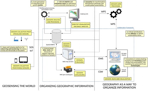
The following subsections present examples of real-world, high-impact FOSS4G applications related to each of the seven FE key outputs noted in . The purpose is to illustrate the suitability and capability of FOSS4G to fulfill the needs and requirements of FE.
4.1. Open and inclusive platforms for observing and monitoring the status, trends and thresholds of the planet in a timely manner at different scales, including tracking fast-changing sentinel processes and systems
This FE need is addressed by systems that support the collection, storage, management, analysis, and reporting of environmental data in real-time or almost real-time. Such systems can be fully based on FOSS/FOSS4G software options. This area primarily includes FOSS4G applications for managing observations collected from monitoring sensors. For instance, istSOS has been used in the EU ENORASIS projectFootnote64 as the basis of a Decision Support System (DSS) to optimize irrigation management by farmers and water management organizations (Cannata and Antonovic Citation2015a). It is also used in the Integrated Management of Red River System (IMRR) project to manage observational data collected by sensors in the Red River Basin (Vietnam)Footnote65 for the purpose of visualizing, analyzing, and comparing different planning alternatives for the management of the river water system (Arias et al. Citation2015). 52°North SOS implementation is used to report air quality data from different European member states to the European Environment Agency with the purpose of improving the flow of near-real-time air quality data across Europe (Jirka et al. Citation2015). 52°North Sensor Web tools are also applied in the field of oceanography to build ocean observatories, such as in the NeXOS,Footnote66 ODIP II,Footnote67 and FixO3Footnote68 EU projects (Jirka et al. Citation2014).
There are also several FOSS4G crowdsourcing tools that allow a real-time sensing of our planet. ODK is been used by: the Amazon Conservation TeamFootnote69 to monitor deforestation in the Amazon; the African Soil Information ServiceFootnote70 to map soil conditions; the Harvard Humanitarian InstituteFootnote71 to document human rights violations; the Haiti Regeneration InitiativeFootnote72 to monitor agricultural practices, crop productivity, and farmer yields of crops; and D-treeFootnote73 to identify and treat severely malnourished children in a UNICEF-funded project. Brovelli, Minghini, and Zamboni (Citation2015) exploit ODK in a number of projects related to urban planning. Projects based on Geopaparazzi include the development of the Disaster Management Information System of Osaka CityFootnote74; Gasdroide,Footnote75 a system for CO2 monitoring through the link between Geopaparazzi and an ad hoc sensor; Trackoid,Footnote76 a mobile application for real-time fleet and rescue teams coordination; and support for forest field surveys for the Japanese forestry governmental agency.Footnote77 Finally, despite being a desktop GIS uDig was installed on the portable computers of Food and Agriculture Organization (FAO) personnel carrying out agricultural monitoring activities in remote locations.Footnote78
Web platforms offering real-time monitoring of the Earth can be also included in this area. The monitoring platform of polar regions and cryosphere, maintained by Polar View,Footnote79 is a notable example of the use of GeoServer for seamlessly providing large volumes of data,Footnote80 including EO data. GeoServer and OpenLayers are also used within the EUMETSAT map viewerFootnote81 offering weather and climate monitoring from space, and within the LaMMA geoportalFootnote82 which provides global, real-time weather observations.
The area of Big Data is not covered in this paper. However, the collection, storage, manipulation, analysis, and distribution of very large volumes of spatial data will be important activities as part of DE and FE. The CyberGISFootnote83 project aims to establish a fundamentally new software framework via a seamless integration of cyberinfrastructure, GIS, and spatial analysis/modelling capabilities. Part of this project is the CyberGIS Toolkit,Footnote84 a suite of loosely coupled open source geospatial software components that provide computationally scalable spatial analysis and modelling capabilities enabled by advanced cyberinfrastructure.
4.2. Tailored metrics and evaluation tools for well-being and sustainable development
This FE output requires the combination and analysis of socio-economic and environmental data coming from diverse sources to generate metrics and indicators of well-being and sustainable development. Systems that incorporate database management systems with spatial extensions such as PostgreSQL-PostGIS, desktop GIS systems such as QGIS or GRASS GIS, and custom analytical software can be used as platforms to seamlessly integrate and analyze this diverse information. Then other FOSS4G can be used to provide access and distribute the information over the Web (e.g. GeoServer, OpenLayers). An important example is the EU Recharge Green project,Footnote85 which has developed a DSS using GRASS GIS and a QGIS plugin (Garegnani et al. Citation2015) to study the impact of exploiting renewable energy sources in the Alps. GRASS GIS was also used within the SOLAREC (Photovoltaic and solar electricity) EU project,Footnote86 aimed at implementing renewable energy in the EU as a sustainable and long-term energy supply. The Photovoltaic Geographical Information SystemFootnote87 provides a map-based inventory of solar energy resources and assessment of the electricity generation from photovoltaic systems (Šúri et al. Citation2007). The project WebGIS,Footnote88 fully based on GRASS GIS, implements the solar radiation model (Hofierka and Šúri Citation2002) to compute the photovoltaic potential on Europe. The Pakistan Agriculture Information System,Footnote89 which integrates many FOSS4G packages such as GeoServer, GeoNetwork, and OpenLayers, provides a rich set of analyses and geoprocessing of data of Pakistan’s crops and agro-meteorological variables. Similarly, the Global Atlas for Renewable Energy of International Renewable Energy Agency (IRENA),Footnote90 is based on GeoServer and OpenLayers, it offers high quality data for solar and wind project assessments and policy planning. The geoUmbriaSUIT QGIS pluginFootnote91 performs sustainability assessment in a GIS environment using a multi-criteria algorithm based on environmental, economic and social criteria.
4.3. A new generation of integrated Earth system models to deepen our understanding of complex Earth systems and human dynamics across different disciplines, and to underpin systems-based policies and strategies for sustainable development
The efficient and timely creation of complex integrated Earth system models capable to analyze and simulate diverse conditions and changes will require the reuse of functionality already available in FOSS/FOSS4G software and the development of new ones. FOSS/FOSS4G is uniquely poised to make major contributions in this arena for two reasons. First, FOSS4G already offers a suit of sophisticated analytical capabilities, and second, because the source code is open and modular, developers can integrate FOSS4G, or extract and reuse some of their functionality to incorporate it into larger more complex analytical and simulation systems of both physical and human-environment interactions. For example, GRASS GIS has been extensively used for modelling the ecology of both plant and animal invasive species (e.g. Neteler et al. Citation2011; Pitt, Kriticos, and Dodd Citation2011; and the GlobalChangeBiology projectFootnote92). It has been also used to simulate and predict the long-term evolution of the Paneveggio forest (northern Italy) based on changes in human activities (Tattoni, Ciolli, and Ferretti Citation2011) and to correlate changes in the agro-forest landscape with the loss of traditional ecological knowledge (Ianni, Geneletti, and Ciolli Citation2015). GRASS GIS and R have been used to monitor the presence of primates in relation to human disturbances (Cavada et al. Citation2016). Designed around QGIS, the Water Observation and Information SystemFootnote93 is a decision support tool that integrates processing and hydrological modelling for cost-effective management of water resources in Africa. A pluginFootnote94 for gvSIG based on JGrassToolsFootnote95 performs modelling and simulation to optimize management of water supply systems, while SAGA is used for the spatial modelling of natural hazards in the Bavarian Alps (Kerkhof and Becht Citation2006). The Global Disaster Alert and Coordination System,Footnote96 jointly developed by the European Commission and the UN, combines Web-based geoprocessing using ZOO WPS and GRASS GIS to alert the international community in case of major sudden disasters. Finally, ZOO WPS was used to create DSS for rainfall modelling as part of a FOSS4G architecture to build a geoportal for North Vietnam (Brovelli, Quang, and Fenoy Citation2013).
4.4. Science-based data, tools and resources to support improved resilience of people, communities and economies, including disaster-risk reduction
The production of science-based data is increasing at an exponential rate. The processing of big amounts of data in a timely fashion is becoming a major challenge. To approach these types of issues Spatial Databases, such as PostGIS, are becoming an invaluable tool. In the United States at the National Renewable Energy LabFootnote97 PostGIS is being used to process data in an effective and scalable manner to support the institution’s mission (Getman Citation2015). SpatiaLite is also commonly used worldwide thanks to its simplicity, ease of use and flexibility. Apart from its well-known integration in other FOSS/FOSS4G projects (e.g. Debian, Fedora, GDAL, QGIS, R, Geopaparazzi, and OpenStreetMap), SpatiaLite is currently used for FE-related needs by a large number of organizations such as the managers of the Yellowstone National Park and Idaho nature reserves, the Mozambique government, the World Health Organization to monitor bird flu in the Southeast Asia, and the National Oceanic and Atmospheric Administration for oceanic studies. These applications were described by Alessandro Furieri, the creator of SpatiaLite, in a personal communication to the authors on February 19, 2016. An important application of Rasdaman is the storage of netCDF output files generated by the Global Flood Awareness System (GloFAS),Footnote98 which uses a hydrological model to produce daily river flood forecasts at the global scale. Rasdaman is also at the core of the EU EarthServer project,Footnote99 which is building a platform for optimizing access to big data from Earth observation systems. Applications of MySQL Spatial include the Korean local governments management systems of their water supply network and hazardous material transportation. CouchDB is used in an online planning support system to predict fire behaviour (Choi et al. Citation2015). MongoDB is used in an application performing spatio-temporal visualization and analyses of telecommunication data flows in urban areas (Brovelli, Minghini, and Zamboni, Citationin press).
The role of geodata catalogues is crucial to manage, describe, search, and retrieve geospatial data. Applications of GeoNetwork (which integrates other FOSS4G tools like OpenLayers) have been deployed by diverse organizations such as the geocatalogues of the FAO,Footnote100 the Netherlands Environmental Assessment Agency,Footnote101 the Australian Institute of Marine Science,Footnote102 the ISRIC – World Soil Information,Footnote103 the Netherlands Coordination Office of the UN Spatial Data Infrastructure,Footnote104 and the geoportal of the Global Earth Observation System of Systems.Footnote105 A noteworthy implementation of pyCSW is the Platform for Urban Management and AnalysisFootnote106 of the World Bank, focused on the study of urban and population expansion.
A significant example of a fully FOSS4G-based project to support the use and reuse of data is Publica Mundi.Footnote107 It uses several FOSS4G here mentioned including Rasdaman, PostGIS, ZOO, GeoServer, and OpenLayers to support the full life cycle of open geospatial data and enable the development of cross-boundary, demand-aware, and scalable applications. ZOO WPS is also used together with other FOSS4G tools for the Osaka City University Disaster-Risk Reduction Project,Footnote108 a WebGIS system based on OpenLayers to promote disaster-risk awareness through community disaster prevention education. ZOO is used for computing on the Web both the risk factor of buildings and the routes to the nearest rescue shelter.
4.5. Scenarios for transformative development pathways that enable global sustainability, to help evaluate different strategies and options
This FE need requires the support of systems that can clearly and eloquently present information on current conditions, and illustrate scenarios in a compelling way that inspire people and institutions to change toward sustainable development alternatives. Both desktop and Web-based FOSS4G technologies can be used to run model simulations and evaluate/choose optimal alternatives for meeting sustainable development goals. GRASS GIS was used as early as the 1990s as a modelling and simulation platform in a DSS for hazardous waste management (Frysinger, Thomas, and Parsons Citation1993). A more recent example is the SITGAP DSS (Cannata and Antonovic Citation2015b) used by the Civil Protection Agency of Locarno and Vallemaggia (Switzerland). The system is based on an open source architecture that uses PostGIS, GeoServer, istSOS, pyWPS, and OpenLayers. The system integrates several information sources to perform hydrological modelling, provide meteorological forecasts and evaluate risk scenarios. Similarly, the above mentioned ENORASIS and IMRR projects perform natural resources management optimization using FOSS/FOSS4G software. The former implements the well-known Weather Research & Forecasting open source model,Footnote109 while the latter is based on an open source stack including Drupal, istSOS, Geoserver, OpenLayers, and Octave.
4.6. Critical contributions to key debates on global sustainability issues, including inputs to scientific assessments and decision-relevant syntheses
Robust and well-established FOSS4G (as well as private/proprietary/closed-source) applications in this field have yet to be developed. However, an interesting start in this direction is provided by the collaboration frameworks mentioned in Section 1. Among the notable implementations of GeoNode the following are worth mentioning. The Joint Research Center (JRC) of the European Commission, created an SDI to collect and disseminate results of geospatial analysis related to the assessment of the impact of the Syrian crisis.Footnote110 The UN World Food Program (WFP), created a platform to enhance preparedness for humanitarian emergencies.Footnote111 The US Department of State, created an application for publishing open geodata produced by government agencies to support decision-makers and partners during complex emergencies, natural disasters, and diplomatic activities worldwide.Footnote112 GeoNode is also used in a collaboration platform created by the World Bank to share geospatial data for the development of Haiti,Footnote113 and as an integrated management platform for enhancing environmental monitoring and inform decision-making in the Caribbean region.Footnote114 An important open source application built on top of GeoNode is Geospatial capabilities for Security, Humanitarian Assistance, Partner Engagement (GeoSHAPE),Footnote115 designed to enable geo-collaboration between mission partners in coordinated and uncoordinated operations. The most relevant application of PoliCrowd is on a platform for sustainable tourism in northern Italy (Brovelli and Zamboni Citation2015).
4.7. Innovations in communicating, engaging and visualising global change and sustainability, fully exploiting the potential of new technologies and overcoming differential access to information across the world
FOSS/FOSS4G in this area can play an important role by facilitating access to cutting-edge software and functionality and helping to reduce the digital divide that separates developed from developing nations (James Citation2003). Also, the visualization capabilities available in several FOSS4G such as in 2D and 3D Web clients (which often represent the only visible part of the architecture depicted in ) enable the interactive visualization of geospatial data stored in databases published through the Web. Examples of 2D applications based on FOSS4G are the OSM (OpenStreetMap) Tasking ManagerFootnote116 used by HOT (Humanitarian OpenStreetMap Team) to coordinate the collaborative mapping in areas hit by natural disasters, and the forecast viewerFootnote117 of the GloFAS system mentioned above. The former makes use of Leaflet, while the latter uses MapServer and OpenLayers for the display of data. MapServer and OpenLayers were also used to create the popular Minnesota Department of Natural ResourcesFootnote118 WebGIS system. Coupled with GeoServer, OpenLayers is also used by FAO to display global major fishing areas of tunas and billfishesFootnote119 and aquatic species distribution.Footnote120 PostGIS, GeoServer, and OpenLayers are the foundation of the geoportalFootnote121 for GlobeLand30, the first global land cover dataset at 30 meters resolution (Chen et al. Citation2014; Han et al. Citation2015). It is worth mentioning that the first accuracy assessment of this dataset at a national level was also performed using FOSS4G (Brovelli et al. Citation2015). The map viewer of European Space Agency (ESA) Sentinels Scientific Data Hub,Footnote122 which provides distributed mirror archives and bulk dissemination capabilities for the EO Sentinels products, is based on OpenLayers also. It is worth mentioning that the geoportal of the Swiss Confederation,Footnote123 is also built using OpenLayers. It was recently awarded the ‘2015 eGovernment special prize’ (Swiss Confederation Citation2015). Many applications of OpenLayers have been also described in the previous subsections. A system featuring OpenLayers and Leaflet viewers as well as several other FOSS4G solutions (PostGIS, MySQL, MapServer, GeoServer, deegree, and GeoNetwork) is the Bolivia’s SDI, named GeoBolivia.Footnote124
Among 3D systems using open source Virtual Globes it is worth mentioning EOLi (Earth Observation Link), the European Space Agency’s client for Earth Observation Catalogue and Ordering Services,Footnote125 and a monitoring toolFootnote126 developed by the US Federal Aviation Administration providing meaningful visualizations of rich amounts of data at various scales. Both are based on World Wind (a Virtual Globe developed by NASA). World Wind is also embedded in the ESA Sentinel Application Platform (SNAP) Desktop application,Footnote127 which allows to visualize and process Sentinel and other EO data, and in the Wildfire Management ToolFootnote128 which implements an advanced model to predict fire behaviour. Among Cesium’s applications related to FE themes it is worth mentioning the 3D Harvesting Planter,Footnote129 a decision-making environment for forestry management, and the mobile Web app Waterway information for Vessels (WAVE),Footnote130 providing emergency information to fishermen in Louisiana. Finally, the energyglobe applicationFootnote131 exploits WebGL Earth virtual globe for visualizing global energy patterns over time.
Also worth mentioning are systems that incorporate physical models with 2D and 3D such as the Tangible Landscape system.Footnote132 This system is a collaborative modelling environment for analysis of terrain changes. It combines a scanner, projector and a physical 3D model with GRASS GIS to analyse the impact of terrain changes by capturing the changes on the physical model, bringing them into the GIS, performing desired analysis or simulation and projecting the results back on the model in real-time (Petrasova et al. Citation2015).
5. Conclusions and recommendations
The reasons for FOSS/FOSS4G adoption vary from pragmatic to ideological, but they should be based not only on their technical merit, their no-cost feature, or their access to the source code. Adopting FOSS/FOSS4G for the wrong reasons can have unintended consequences, while not adopting them might leave considerable opportunities and benefits unused (Moreno-Sanchez Citation2012). FOSS4G software should be evaluated at par with their private/proprietary/closed-source counterparts to select the solution that best addresses the context and informational needs where they will be used to develop the components, systems, and functionality that will be part of DE and FE. FOSS4G capabilities, range of applications, and user/developer/education communities have been growing and maturing rapidly around the world. Today there are more implementation experiences, educational resources, personnel know-how, commercial support services, and larger more experienced user/developer communities. These developments, among others, are reducing the impact of inhibitors that in the past have impacted the uptake of FOSS/FOSS4G solutions.
Because of their purpose and ultimate goals, DE and FE will be developed and maintained around the world following a philosophy of openness, sharing, and distributed-collaborative development. Technologies like FOSS/FOSS4G that align with this philosophy by being open, breaking barriers, facilitating access, and fostering the creation of communities of interest will play an important role in realizing the DE and FE visions. This paper has shown that there are already many stable implementations of FOSS4G solutions in high-level organizations working on large, sophisticated, mission-critical operations. These examples demonstrate the robustness, reliability and suitability of FOSS4G for contributing to achieve the FE vision and goals. Thanks to their modularity, openness, and extensibility, FOSS4G solutions are positioned to contribute to the realization of DE and FE visions. FOSS4G and its user/developer/education communities are clearly ready and capable to contribute to the FE endeavour, no doubt one of the most critical of the twenty-first century.
Acknowledgments
The authors would like to sincerely thank the many people who provided references and links to the meaningful FOSS4G applications listed in Section 4.
Disclosure statement
No potential conflict of interest was reported by the authors.
ORCiD
Marco Minghini http://orcid.org/0000-0001-9993-1072
Notes
References
- Annoni, A., M. Craglia, M. Ehlers, Y. Georgiadou, A. Giacomelli, M. Konecny, N. Ostlaender, et al. 2011. “A European Perspective on Digital Earth.” International Journal of Digital Earth 4 (4): 271–284. doi:10.1080/17538947.2011.582888.
- Arias, C., M. A. Brovelli, S. Corti, M. Micotti, E. Weber, and R. S. Sessa. 2015. “A FOSS Approach to Integrated Water Resource Management: The Case Study of Red-Thai Binh Rivers System in Vietnam.” Geomatics Workbooks 12: 471–476. Accessed February 28. http://geomatica.como.polimi.it/workbooks/n12/FOSS4G-eu15_submission_100.pdf.
- Botts, M., G. Percivall, C. Reed, and J. Davidson. 2008. “OGC® Sensor Web Enablement: Overview and High Level Architecture.” In GeoSensor Networks, edited by A. Stefanidis and S. Nittel, 175–190. CRC Press.
- Brovelli, M. A., P. Hogan, M. Minghini, and G. Zamboni. 2013. “The Power of Virtual Globes for Valorising Cultural Heritage and Enabling Sustainable Tourism: NASA World Wind Applications.” International Archives of the Photogrammetry, Remote Sensing and Spatial Information Sciences XL-4/W2: 115–120. doi:10.5194/isprsarchives-XL-4-W2-115-2013.
- Brovelli, M. A., M. Minghini, and G. Zamboni. In press. “New Generation Platforms for Exploration of Crowdsourced Geo-Data.” In Changing the World One Pixel at a Time, edited by P. P. Mathieu and C. Aubrecht. Berlin: Springer.
- Brovelli, M. A., M. Minghini, and G. Zamboni. 2014. “Three Dimensional Volunteered Geographic Information: A Prototype of a Social Virtual Globe.” International Journal of 3-D Information Modeling 3 (2): 19–34. doi:10.4018/ij3dim.2014040102.
- Brovelli, M. A., M. Minghini, and Zamboni, G. 2015. “Public Participation GIS: A FOSS Architecture Enabling Field-Data Collection.” International Journal of Digital Earth 8 (5): 345–363. doi:10.1080/17538947.2014.887150.
- Brovelli, M. A., M. Minghini, and G. Zamboni. 2016. “Participation in GIS via Mobile Applications.” ISPRS Journal of Photogrammetry and Remote Sensing 114: 306–315. doi:10.1016/j.isprsjprs.2015.04.002.
- Brovelli, M. A., M. E. Molinari, E. Hussein, J. Chen, and R. Li. 2015. “The First Comprehensive Accuracy Assessment of GlobeLand30 at a National Level: Methodology and Results.” Remote Sensing 7 (4): 4191–4212. doi:10.3390/rs70404191.
- Brovelli, M. A., T. X. Quang, and G. Fenoy. 2013. “Managing Satellite Precipitation Data (PERSIANN) through Web GeoServices: A Case Study in North Vietnam.” In Intelligent Systems for Crisis Management, edited by S. Zlatanova, R. Peters, A. Dilo, and H. Scholten, 159–170. Berlin: Springer.
- Brovelli, M. A., and G. Zamboni. 2015. “A 3D Social Platform for the Paths of Via Regina.” International Archives of Photogrammetry, Remote Sensing and Spatial Information Sciences XL-4/W7: 23–30. doi:10.5194/isprsarchives-XL-4-W7-23-2015.
- Brovelli, M. A., G. Zamboni, and C. A. Muñoz. 2015. “From Paper Maps to the Digital Earth and the Internet of Places.” Rendiconti Lincei 26 (1): 97–103. doi:10.1007/s12210-015-0437-y.
- Bruce. R. 2007. “A survey of Open Source Geospatial Software.” Presentation for the Association of Professional Engineers and Geoscientists of the Province of Manitoba (APEGM). Accessed June 23. http://www.apegm.mb.ca/pdf/PD_Papers/os-geospatial-sw.pdf.
- Camara, G., and F. Fonseca. 2007. “Information Policies and Open Source Software in Developing Countries.” Journal of the American Society for Information Science and Technology 58: 121–132. doi:10.1002/asi.v58:1.
- Cannata, M., and M. Antonovic. 2015a. “Sensor Observations Service for Environmentally Optimizing Irrigation: istSOS within the ENORASIS Example.” International Journal of Geoinformatics 11 (3): 1–8. Accessed February 28. http://journals.sfu.ca/ijg/index.php/journal/article/view/622.
- Cannata, M., and M. Antonovic. 2015b. “SITGAP2, a Decision Support System for Floods Management Based on Open Source and Open Standards.” Geomatics Workbooks 12: 459–462. Accessed February 27. http://geomatica.como.polimi.it/workbooks/n12/FOSS4G-eu15_submission_82.pdf.
- Cavada, N., C. Barelli, M. Ciolli, and F. Rovero. 2016. “Primates in Human-Modified and Fragmented Landscapes: The Conservation Relevance of Modelling Habitat and Disturbance Factors in Density Estimation.” PLoS ONE 11 (2): e0148289. doi:10.1371/journal.pone.0148289.
- Chen, J., J. Chen, A. Liao, X. Cao, L. Chen, X. Chen, C. He, et al. 2014. “Global Land Cover Mapping at 30 m Resolution: A POK-Based Operational Approach.” ISPRS Journal of Photogrammetry and Remote Sensing 103: 7–27. doi:10.1016/j.isprsjprs.2014.09.002.
- Chen, D., S. Shams, C. Carmona-Moreno, and A. Leone. 2010. “Assessment of Open Source GIS Software for Water Resources Management in Developing Countries.” Journal of Hydro-Environment Research 4 (3): 253–264. doi:10.1016/j.jher.2010.04.017.
- Choi, J., H. Kim, J. Ahn, and J. Kim. 2015. “FOSS4G for Rapidly Urbanizing Cities and UN Sustainable Development Goals (SDGs); SDG 11 Cities and Human Settlement.” Presented at FOSS4G 2015, Seoul, September 14–19, 2015. Accessed February 25. http://www.slideshare.net/junyoungchoi50159/foss4g-for-rapidly-urbanizing-cities-and-un-sustainable-development-goalssdgs-sdg-11-cities-and-human-settlement.
- Craglia, M., K. de Bie, D. Jackson, M. Pesaresi, G. Remetey-Fülöpp, C. Wang, A. Annoni, et al. 2012. “Digital Earth 2020: Towards the Vision for the Next Decade.” International Journal of Digital Earth 5 (1): 4–21. doi:10.1080/17538947.2011.638500.
- Craglia, M., M. F. Goodchild, A. Annoni, G. Camara, M. Gould, W. Kuhn, D. Mark, et al. 2008. “Next-Generation Digital Earth: A Position Paper from the Vespucci Initiative for the Advancement of Geographic Information Science.” International Journal of Spatial Data Infrastructures Research 3: 146–167. doi:10.2902/1725-0463.2008.03.art9.
- CRM-Reviews. 2006. “50 Open source success stories in business, education and government.” Accessed June 23. http://www.crm-reviews.com/50-open-source-success-stories-in-business-education-and-government
- Ellis, J., and J. P. Van Belle. 2009. “Open Source Software Adoption by South African MSEs: Barriers and Enablers.” In Proceedings of the 2009 Annual Conference of the Southern African Computer Lecturers’ Association, 41–49. ACM.
- Erlich, Z., and R. Aviv. 2007. “Open Source Software: Strengths and Weaknesses.” In Handbook of Research Open Source Software: Technological, Economic and Social Perspectives, edited by K. St. Amant and B. Still, 184–196. Hershey, PA: IGI Global. doi:10.4018/978-1-59140-999-1.ch015.
- Faber, S. 2007. “Geoserver and Open Standards: A success story.” In Proceedings of FOSS4G 2007, Victoria, British Columbia, September 24–27, 2007. Accessed February 20. http://2007.foss4g.org/presentations/view.php?abstract_id=8.
- Fitzgerald, B. 2011. “Open Source Software Adoption: Anatomy of Success and Failure.” International Journal of Open Source Software & Processes v1 i1: 1–23. doi:10.4018/978-1-60960-513-1.ch001.
- Frysinger, S. P., R. P. Thomas, and A. M. Parsons. 1993. “Hydrological Modelling and GIS: The Sandia Environmental Decision Support System.” In Applications of Geographic Information Systems in Hydrology and Water Resources. Proceedings of the International Conference HydroGIS ‘93, Vienna, IAHS Publication No. 211, 45–50. Accessed February 28. http://hydrologie.org/redbooks/b211/211006.pdf.
- Future Earth Norway Secretariat. 2015. “Future Earth Norway.” Accessed February 28. http://www.futureearth.org/sites/default/files/files/Summary%20and%20Reflections_Future%20Earth%20Norway%207%20May%202015%20Workshop%20%281%29.pdf.
- Future Earth Secretariat. 2013. Future Earth Initial Design: Report of the Transition Team. Paris: International Council for Science (ICSU). Accessed February 28. http://www.icsu.org/future-earth/media-centre/relevant_publications/future-earth-initial-design-report.
- Future Earth Secretariat. 2014. “Future Earth 2025 Vision.” Accessed February 28. http://www.futureearth.org/sites/default/files/files/Future-Earth_10-year-vision_web.pdf.
- Garbin, D., and J. L. Fisher. 2010. “Open Source for Enterprise Geographic Information Systems.” IT Professional 12 (6): 38–45. Accessed June 23. http://search.proquest.com/docview/815855488?pq-origsite=gscholar. doi: 10.1109/MITP.2010.152
- Garegnani, G., F. Geri, P. Zambelli, G. Grilli, S. Sacchelli, A. Paletto, G. Curetti, M. Ciolli, and D. Vettorato. 2015. “A New Open Source DSS for Assessment and Planning of Renewable Energy: R. Green.” Geomatics Workbooks 12: 39–49. Accessed February 28. http://geomatica.como.polimi.it/workbooks/n12/FOSS4G-eu15_submission_81.pdf.
- Getman, Dan. 2015. “Visualization and Analysis of Spatiotemporal Data Using Free and Open Source Software at the National Renewable Energy Laboratory.” Presented at GIS on the Rockies, Denver, September 24, 2015. Accessed February 28. http://www.slideshare.net/GISITR/2015-foss4g-track-visualization-and-analysis-of-spatiotemporal-data-using-free-and-open-source-software-at-the-national-renewable-energy-laboratory-by-dan-getman.
- Giera, J., and A. Brown. 2004. “The Costs and Risks of Open Source.” Report, Forrester Research. Accessed February 28. http://www.joassoc.com/inc/whitepapers/FRSTRossCosts0404.pdf.
- Gillespie, R. 2000. “German Federal Government to Support Open Source Software.” Internetnews.com 5 July. Accessed June 23. http://www.internetnews.com/bus-news/article.php/408271/German+Federal+Government+to+Support+Open+Source+Software.htm.
- GNU Project. 1996. “What is Free Software? The Free Software Definition.” Accessed February 28. http://www.gnu.org/philosophy/free-sw.en.html.
- Goodchild, M. F. 2007. “Citizens as Sensors: The World of Volunteered Geography.” GeoJournal 69 (4): 211–221. doi:10.1007/s10708-007-9111-y.
- Goodchild, M. F., H. Guo, A. Annoni, L. Bian, K. de Bie, F. Campbell, M. Craglia, et al. 2012. “Next-Generation Digital Earth.” Proceedings of the National Academy of Sciences 109 (28): 11088–11094. doi:10.1073/pnas.1202383109.
- Gore, A. 1998. “The Digital Earth: Understanding Our Planet in the 21st Century.” Australian Surveyor 43 (2): 89–91. doi:10.1080/00050326.1998.10441850.
- Hall, G. B., and M. G. Leahy. 2008. Open Source Approaches in Spatial Data Handling. Berlin: Springer. doi:10.1007/978-3-540-74831-1.
- Han, G., J. Chen, C. He, S. Li, H. Wu, A. Liao, and S. Peng. 2015. “A Web-Based System for Supporting Global Land Cover Data Production.” ISPRS Journal of Photogrammetry and Remote Sensing 103: 66–80. doi:10.1016/j.isprsjprs.2014.07.012.
- Hauge, Ø., D. S. Cruzes, R. Conradi, K. S. Velle, and T. A. Skarpenes. 2010. “Risks and Risk Mitigation in Open Source Software Adoption: Bridging the Gap Between Literature and Practice.” In Open Source Software: New Horizons, edited by P. Ågerfalk, C. Boldyreff, J. M. González-Barahona, G. R. Madey, and J. Noll, 105–118. Berlin: Springer. doi:10.1007/978-3-642-13244-5_9.
- Hippel, E. V., and G. V. Krogh. 2003. “Open Source Software and the ‘Private-Collective’ Innovation Model: Issues for Organization Science.” Organization Science 14 (2): 209–223. doi:10.1287/orsc.14.2.209.14992.
- Hofierka, J., and M. Šúri. 2002. “The Solar Radiation Model for Open Source GIS: Implementation and Applications.” In Proceedings of the Open source GIS-GRASS Users Conference, 1–19. Accessed February 28. https://www.researchgate.net/profile/Jaro_Hofierka/publication/2539232_The_solar_radiation_model_for_Open_source_GIS_implementation_and_applications/links/5523c2c50cf2c74f0dff0cc0.pdf.
- Holmes, C., A. Doyle, and M. Wilson. 2005. “Towards a Free and Open Source Spatial Data Infrastructure.” In Proceedings of the Faraohs to Geoinformatics FIG Working Week 2005 and GSDI-8, Cairo, Egypt, April 16–21, 2015. Accessed June 23. https://www.fig.net/resources/proceedings/fig_proceedings/cairo/papers/ts_26/ts26_05_holmes_etal.pdf.
- Ianni, E., D. Geneletti, and M. Ciolli. 2015. “Revitalizing Traditional Ecological Knowledge: A Study in an Alpine Rural Community.” Environmental Management 56 (1): 144–156. doi:10.1007/s00267-015-0479-z.
- James, J. 2003. “Free Software and the Digital Divide: Opportunities and Constraints for Developing Countries.” Journal of Information Science 29: 25–33. doi: 10.1177/016555150302900103
- Jirka, S., C. Hollmann, M. Rieke, H. Blomgren, M. Grothe, H. Berkhout, T. Bush, P. Olav, and M. Ross-Jones. 2015. “Using the OGC SOS Interface for Reporting Ambient Air Quality Data.” In Adjunct Proceedings of the 29th EnviroInfo and 3rd ICT4S Conference 2015, Copenhagen, September 7–9. Accessed February 28. http://enviroinfo.eu/sites/default/files/pdfs/vol9073/0202.pdf.
- Jirka, S., D. Mihai Toma, J. del Rio, and E. Delory. 2014. “A Sensor Web Architecture for Sharing Oceanographic Sensor Data.” In Proceedings of the Sensor Systems for a Changing Ocean (SSCO), Brest, October 13–17, 2014, IEEE, 1–4.
- Kaneshige, T. 2008. “Open source: What should you learn from the French.” InfoWorld 28 August, 2008. Accessed June 23. http://www.infoworld.com/d/developer-world/open-source-what-you-should-learn-french-461
- Kerkhof, H., and M. Becht. 2006. “Natural Hazard Research in the Bavarian Alps – A Case Study of Mittenwald (Germany).” SAGA: Analysis and Modelling Applications 115: 75–84.
- Kwan, S. K., and J. West. 2005. “A Conceptual Model for Enterprise Adoption of Open Source Software.” The Standards Edge: Open Season 1–14. doi:10.1.1.93.8832.
- Lettice, J. 2004. “Open Source Ready Prime Time in UK.gov, says OGC.” The Register 28 October. Accessed June 23. http://www.theregister.co.uk/2004/10/28/ogc_oss_pilot_report/.
- Li, Y., C. H. Tan, H. Xu, and H. H. Teo. 2011. “Open Source Software Adoption: Motivations of Adopters and Motivations of Non-Adopters.” ACM SIGMIS Database 42 (2): 76–94. doi:10.1145/1989098.1989103.
- Macredie, R. D., and K. Mijinyawa. 2011. “A Theory-Grounded Framework of Open Source Software Adoption in SMEs.” European Journal of Information Systems 20 (2): 237–250. doi:10.1057/ejis.2010.60.
- Marson, I. 2005. “Europe and the US Philosophically Divided on Open Source?” ZDNet UK November 28, 2005. Accessed June 23. http://www.zdnet.com/article/europe-and-the-us-philosophically-divided-on-open-source.
- Minghini, M. 2014. “Multi-Dimensional GeoWeb Platforms for Citizen Science and Civic Engagement Applications.” PhD thesis, Politecnico di Milano, Italy. Accessed February 28. http://hdl.handle.net/10589/89726.
- Mitasova, H., and M. Neteler. 2004. “GRASS as Open Source Free Software GIS: Accomplishments and Perspectives.” Transactions in GIS 8 (2): 145–154. doi:10.1111/j.1467-9671.2004.00172.x.
- Meeker, H. J. 2008. The Open Source Alternative: Understanding Risks and Leveraging Opportunities. Hoboken, NJ:John Wiley & Sons.
- Molina, Martin, and Salvador Bayarri. 2011. “A Multinational SDI-Based System to Facilitate Disaster Risk Management in the Andean Community.” Computers & Geosciences 1501–1510. doi:10.1016/j.cageo.2011.01.015.
- Moreno-Sanchez, R. 2012. Guest Editorial. “Free and Open Source Software for Geospatial Applications (FOSS4G): A Mature Alternative in the Geotechnologies Arena.” Transactions in GIS 16 (2): 81–88. doi:10.1111/j.1467-9671.2012.01314.x.
- Moreno-Sanchez, R., G. Anderson, J. Cruz, and M. Hayden. 2007. “The Potential for the Use of Open Source Software and Open Specifications in Creating Web-Based Cross-Border Health Spatial Information Systems.” International Journal of Geographical Information Science 21 (10): 1135–1163. doi:10.1080/13658810701300113.
- Morgan, L., and P. Finnegan. 2007. “How Perceptions of Open Source Software Influence Adoption: An Exploratory Study.” https://ulir.ul.ie/bitstream/handle/10344/1980/2007_Morgan.pdf?sequence=2.
- Nagy, D., A. M. Yassin, and A. Bhattacherjee. 2010. “Organizational Adoption of Open Source Software: Barriers and Remedies.” Communications of the ACM 53 (3): 148–151. doi:10.1145/1666420.1666457.
- Nakayama, Yu, and Suguru Mori. 2012. “FOSS4G Based Mobile Web-GIS for Field Survey in Natural Environmental Studies.” In 9th International Conference on Ubiquitous Intelligence and Computing and 9th International Conference on Autonomic and Trusted Computing. doi:10.1109/uic-atc.2012.38.
- Neteler, M., D. Roiz, D. Rocchini, C. Castellani, and A. Rizzoli. 2011. “Terra and Aqua Satellites Track Tiger Mosquito Invasion: Modelling the Potential Distribution of Aedes Albopictus in North-Eastern Italy.” International Journal of Health Geographics 10 (49). doi:10.1186/1476-072X-10-49.
- Noronha, F. 2002. “Open Source Software Opens New Windows to Third-world.” Linux Journal, May 3. Accessed February 25. http://www.linuxjournal.com/article/6049.
- Noronha, F. 2003. “Developing Countries Gain from Free/Open Source Software.” Linux Journal, May 20. Accessed February 25. http://www.linuxjournal.com/article/6884.
- Open Geospatial Consortium. 2015. OGC® SensorThings API. OpenGIS® Candidate Standard, Version 0.9.4. Accessed February 25. https://portal.opengeospatial.org/files/?artifact_id=64146.
- Petrasova, A., B. Harmon, V. Petras, and H. Mitasova. 2015. Tangible Modeling with Open Source GIS. Springer International Publishing. doi:10.1007/978-3-319-25775-4.
- Pitt, J. P., D. J. Kriticos, and M. B. Dodd. 2011. “Temporal Limits to Simulating the Future Spread Pattern of Invasive Species: Buddleja Davidii in Europe and New Zealand.” Ecological Modelling 222 (11): 1880–1887. doi:10.1016/j.ecolmodel.2011.03.023.
- Qu, W. G., Z. Yang, and Z. Wang. 2011. “Multi-Level Framework of Open Source Software Adoption.” Journal of Business Research 64 (9): 997–1003. doi:10.1016/j.jbusres.2010.11.023.
- Rajani, N., J. Rekola, and T. Mielonen. 2003. Free as in Education Significance of the Free/Libre Open Source Software for Developing Countries. Helsinki: Ministry of Foreign Affairs. Accessed February 28. http://www.itu.int/wsis/docs/background/themes/access/free_as_in_education_niranjan.pdf.
- Sanz-Salinas, J. C., and M. Montesinos-Lajara. 2009. “Current Panorama of the Foss4g Ecosystem.” Upgrade 10 (2): 43–51. Accessed February 28. http://www.cepis.org/upgrade/files/issue%20II-2009-sanzsalinas.pdf.
- Schenker, J. L. 2003. “Open Source Software Gets Boost at UN.” International Herald Tribune, The IHT Online, December 11, 2003. Accessed February 25. http://cds.cern.ch/record/729867/?ln=en.
- Steiniger, S., and E. Bocher. 2009. “An Overview on Current Free and Open Source Desktop GIS Developments.” International Journal of Geographical Information Science 23 (10): 1345–1370. doi:10.1080/13658810802634956.
- Steiniger, S., and A. J. Hunter. 2012. “Free and Open Source GIS Software for Building a Spatial Data Infrastructure.” Geospatial Free and Open Source Software in the 21st Century 247–261. doi:10.1007/978-3-642-10595-1_15.
- Steiniger, S., and A. J. Hunter. 2013. “The 2012 Free and Open Source GIS Software Map – A Guide to Facilitate Research, Development, and Adoption.” Computers, Environment and Urban Systems 39: 136–150. doi:10.1016/j.compenvurbsys.2012.10.003.
- Stewart, K. J., and S. Gosain. 2006. “The Impact of Ideology on Effectiveness in Open Source Software Development Teams.” Mis Quarterly 30 (2): 291–314. Accessed February 25. http://flosshub.org/sites/flosshub.org/files/stewartgosain2.pdf.
- Šúri, M., T. Huld, E. D. Dunlop, and J. Hofierka. 2007. “Solar Resource Modelling for Energy Applications.” In Digital Terrain Modelling, 259–273. Berlin: Springer.
- Swain, Nathan R., Kilisimasi Latu, Scott D. Christensen, Norman L. Jones, E. James Nelson, Daniel P. Ames, and Gustavious P. Williams. 2015. “A Review of Open Source Software Solutions for Developing Water Resources Web Applications.” Environmental Modelling & Software 108–117. doi:10.1016/j.envsoft.2015.01.014.
- Swiss Confederation. 2015. “2015 eGovernment Special Prize Awarded to geo.admin.ch, the Geoportal of the Swiss Confederation.” Accessed 28 February. https://www.news.admin.ch/message/index.html?lang=en&msg-id=59628.
- Tattoni, C., M. Ciolli, and F. Ferretti. 2011. “The Fate of Priority Areas for Conservation in Protected Areas: A Fine-Scale Markov Chain Approach.” Environmental Management 47 (2): 263–278. doi:10.1007/s00267-010-9601-4.
- Tsou, M.-H., and J. Smith. 2011. “Free and Open Source Software for GIS education.” Unpublished White Paper Prepared for the GeoTech Center. Accessed June 23. http://www.iapad.org/wp-content/uploads/2015/07/tsou_free-GIS-for-educators-whitepaper.pdf.
- Välimäki, M., V. Oksanen, and J. Laine. 2005. “An Empirical Look at the Problems of Open Source Adoption in Finnish Municipalities.” In Proceedings of the 7th international conference on Electronic Commerce, 514–520. ACM. doi:10.1145/1089551.1089643.
- Ven, K., J. Verelst, and H. Mannaert. 2008. “Should You Adopt Open Source Software.” IEEE Software 25 (3): 54–59. Accessed June 23. https://lists.ellak.gr/open-source/2008/05/pdfJLaDOCyA2x.pdf. doi: 10.1109/MS.2008.73
- Viorres, N., P. Xenofon, M. Stavrakis, E. Vlachogiannis, P. Koutsabasis, and J. Darzentas. 2007. “Major HCI Challenges for Open Source Software Adoption and Development.” In Online Communities and Social Computing, edited by D. Schuler, 455–464. Berlin: Springer.
- Walli, S., D. Gynn, and B. Von Rotz. 2005. “The Growth of Open Source Software in Organizations.” Accessed June 23. http://www.novell.com/news/press/pressroom/wp_optaros_oss_usage_in_organizations.pdf.
- Wambui, M. 2004. Africa Should Make More Use of Free and Open Source Software. Nairobi: United Nations Economic Commission for Africa. Accessed February 25. http://www.uneca.org/eca_resources/news/042805disdcodi_dna.htm.
- Wang, H., and C. Wang. 2001. “Open Source Software Adoption: A Status Report.” IEEE Software 18 (2): 90–95. Accessed June 23. http://citeseerx.ist.psu.edu/viewdoc/download?doi=10.1.1.474.2244&rep=rep1&type=pdf. doi: 10.1109/52.914753
- Weber, S. 2004. The Success of Open Source. Cambridge, MA: Harvard University Press.
- Woods, D., and G. Guliani. 2005. Open Source for the Enterprise: Managing Risks, Reaping Rewards. Sebastopol, CA: O’Reilly Media.
- Yangyong, Z., and X. Yun. 2015. “Defining Big Data.” Big Data Research 1 (1): 2015007. doi:10.11959/j.issn.2096-0271.2015007.
- Yao, X., and L. Zou. 2008. “Interoperable Internet Mapping—An Open Source Approach.” Cartography and Geographic Information Science 35 (4): 279–293. General OneFile. doi:10.1559/152304008786140560.