
ABSTRACT
The need and critical importance of global land cover and change information has been well recognized. Although rich collection of such information has been made available, the lack of necessary information services to support its easy access, analysis and validation makes it difficult to find, evaluate, select and reuse them through well-designed workflows. Aiming at promoting the development of the needed global land cover information services, this paper presents a conceptual framework for developing a Collaborative Global Land Cover Information Service (CoGland), followed by discussions on its implementation strategies. The framework supports connected and shared land cover and change web services around the world to address resource sharing, community service and cross-board collaboration needs. CoGland can benefit several recent international initiatives such as Future Earth, and many societal benefit areas. The paper further proposes that CoGland be developed within the framework of the Group on Earth Observations with the support of a number of key organizations such as the United Nations Expert Committee on Global Geospatial Information Management, the International Society for Photogrammetry and Remote Sensing, and International Society of Digital Earth. It is hoped that this paper can serve as a starting point for further discussions on CoGland developments.
1. Introduction
Land cover and change (LCC) refers to the biophysical materials covering the earth surface and their dynamics (Meyer and Turner Citation1994; Mölders Citation2011), and has been regarded as an essential variable for natural resources management, environmental monitoring, urban development, climate change analysis and earth system simulation, among many other earth-related studies (Foley et al. Citation2005; Latifovic et al. Citation2015). In the past few years, a number of LCC data products have been produced at different geographical scales (i.e. global, regional and national) with varied spatial resolution, temporal coverage, thematic details and mapping accuracy (Grekousis, Mountrakis, and Kavouras Citation2015; Diogo and Koomen Citation2016). They have been used to support the United Nations Framework Convention on Climate Change (UNFCCC) (Verburg, Neumann, and Nol Citation2011), the Convention on Biological Diversity (CBD) (O’Connor et al. Citation2015), the Future Earth initiative of the International Council of Science (ICSU) (Reid et al. Citation2010), the 2030 Global Sustainable Development Goals (Scott and Rajabifard Citation2015), and other Societal Benefit Areas (SBA). Whereas the value of these LCC datasets is highly acknowledged, their limitations and weaknesses have also been identified (Ramankutty et al. Citation2006; Mora et al. Citation2014). This has further stimulated intensive research and development activities to generate new LCC data products and provide more valuable information services with advanced technologies (Ban, Gong, and Giri Citation2015; Chen et al. Citation2015, Citation2016; Chen, Dowman et al. Citation2016; Gong et al. Citation2016).
Web service and service-oriented computing (SOC) are among such advanced technologies which have been used for encapsulating LCC data and processing functionality as web services to enable easy access without knowledge of, or control over, their internal workings (Foster Citation2005; Chen et al. Citation2013). A number of LCC data products were made available through web map service (WMS) to facilitate online open data access (Han et al. Citation2012; Brovelli et al. Citation2016). Further, some web-based systems have been developed to support LCC data production and updating (Han et al. Citation2015; Zhang et al. Citation2016), crowdsourcing-based validation and geo-tagging (Fritz et al. Citation2012; See et al. Citation2015; Xing, Chen, and Zhou Citation2015), information crawling and service discovery (Hou et al. Citation2015; Hou, Chen, and Wu Citation2016), as well as value-added statistics and analysis (Han et al. Citation2012, Citation2014; Pettit, Tanton, and Hunter Citation2016). A recent service discovery experiment revealed that there are about 11,900 LCC related WMS on the Internet from both surface and deep web (Hou, Chen, and Wu Citation2016). However, these LCC web services are not well connected and are scattered around different organizations (or institutions), forming de facto ‘information islands’. One of the consequences is that it is often very difficult for an end user to find and access the appropriate LCC datasets. In addition, the service functionalities provided by different web systems vary drastically and no one could provide a full set of domain specific ‘functional’ or ‘analytical’ services to cover all aspects of land cover mapping, monitoring and analysis.
Providing a comprehensive LCC service by integrating available LCC data and service resources has now become a necessity for a number of reasons. Firstly, there is a growing need for higher spatial resolution and more temporally frequent LCC data products from different applications, such as food security, forest carbon, biodiversity, climate and sustainability (Verburg, Newmann, and Nol Citation2011; O’Connor et al. Citation2015; Diogo and Koomen Citation2016). Since no single LCC dataset could satisfy different users, it is a common practice to derive user-specific maps by collecting and integrating existing LCC datasets with different classification systems and different levels of accuracy (Tsendbazar, de Bruin, and Herold Citation2016). Secondly, LCC datasets may serve as existing knowledge or ancillary data for the generation and validation of new LCC datasets. For instances, they can be used for selecting training samples from the unchanged areas (Xian, Collin, and Fry Citation2009; Chen et al. Citation2012), determining sample sizes and their spatial distributions (Brovelli et al. Citation2015; Chen et al. 2016), and conducting knowledge-based verification (Mwaniki and Möller Citation2015; Zhang et al. Citation2016). Thirdly, the number of people working in the area of LCC (such as data producers, users and researchers) has increased rapidly and is forming a large LCC community. They share common interests and require specific community-based services, such as data production and updating, validation and geo-tagging, spatial statistics and analysis. One example is the on-demand land cover change detection and updating, which can be facilitated by a community-specific geo-processing service that selects and reuses relevant models and algorithms from the web resources (Xing et al. Citation2016). This requires the development of new approaches for dynamic discovery and composition of services (Yue, Wang, and Zhou Citation2004; Zhang and Zhou Citation2009; Chen et al. Citation2013).
Moving from individual LCC services to a collaborative global land cover (GLC) information service (CoGland) is a natural way for building such comprehensive LCC services. Its basic idea is to connect all available global, regional and national LCC web services and to deliver ‘one-stop’ community-based services. It will enable efficient LCC data sharing and enhance the value-added applications of the LCC information. This paper examines the requirements, issues and challenges on the integration of available LCC web services and the provision of collaborative LCC information services. A conceptual framework for CoGland design and development is then proposed and discussed, including its nature and concept, components, relationships with other related developments, and implementation strategies, especially as a Group on Earth Observations (GEO) community portal. The rest of this paper is organized as follows. Section 2 introduces some web-based land cover information systems as examples of operational LCC web services. Section 3 examines the needs for collaborative land cover information services, followed by the conceptual framework of CoGland in Section 4. Before conclusions, Section 5 suggests a road map for its implementation and discusses how CoGland may be implemented.
2. Status of current online LCC information services
The US Geological Survey (USGS) Earth Explorer was perhaps the first web system at the global level that allowed users to search, discover, download and order earth science data, including national and global land cover datasets. Evolved from an early global land information system (Oleson Citation1993), the web system has been widely used as an efficient vehicle to disseminate land cover datasets or products by data producers. Since then, many organizations and research institutions have published their land cover data, including data products and original remote sensing data over the Internet. These include the US Multi-Resolution Land Characterization (MRLC), the University of Maryland, the EU Joint Research Centre (JRC), the Food and Agriculture Organization of United States (FAO), the Institute of Geographic Sciences and Natural Resources Research of the Chinese Academy of Science, and so on.
Most of these online services aim at serving a single type of dataset with various levels of necessary documentation and metadata about the dataset, allowing users to simply download data in one or more pre-defined formats. Due to historical reasons and technical limitations, the data and services provided by these sites are fragmented in terms of spatial and/or temporal coverage and are not connected. They remain in the stage of providing static snapshot-based information services, and do not well take into account the information about land cover changes and provide services for change detection. Some services allow users to use web map interface to preview, search, extract and crop data prior to downloading. Only a few of them offer tools to perform simple online processing and analysis of datasets such as CropScape, European Space Agency (ESA)/Climate Change Institute (CCI) Viewer and GlobeLand30 described below, in addition to sea ice coverage information services (Li, Xiong, and Ou Citation2011; Liu et al. Citation2015) and land cover data production support (Han et al. Citation2015).
CropScape (http://nassgeodata.gmu.edu/CropScape/), developed by the National Agricultural Statistics Service of the US Department of Agriculture, is a cropland exploring service for querying, visualizing and disseminating US conterminous geospatial cropland data products (Han et al. Citation2012). It contains crop and other related land cover classifications obtained using remote sensing from the year 1997 to 2015. CropScape provides a set of online tools including interactive map operation, data downloading, crop acreage statistics, charting and graphing, and multi-temporal change analysis (Han et al. Citation2014). A useful feature of CropScape is the ‘area of interest’ (AOI), which can be defined, imported and cleared. With a defined AOI, statistics (tabular or graphical), crop changes, PDF document creation and data downloading of the specified area can be provided on the fly, of which the response time depends on the size of the area. Further, CropScape was developed as a web service-based application, which provides web feature service, WMS, web coverage service and web processing service (Han et al. Citation2012).
ESA/CCI Viewer (http://maps.elie.ucl.ac.be/CCI/viewer/), developed mainly as a web interface for visualizing data by the Land Cover Project from the ESA CCI, allows users to select and view the 10-year global MEdium Resolution Imaging Spectrometer surface reflectance product composite, the CCI-LC maps from the 1998–2002, 2003–2008 or 2009–2012 epochs and the water bodies product (CCI Citation2016). Users can also interact with data views to see the display of the basic CCI-LC condition profiles for the normalized difference vegetation index, burned areas and/or the snow reference behaviours. With proper authentication, users can access the tools for extracting the CCI land cover products at specific locations and packing data for downloading, and the user tool for sub-setting, re-projecting and re-sampling the products through the web interface. However, no web services seem to be made available for developers to reuse the resources.
GlobeLand30 (http://www.globallandcover.com/) is a web system specially designed and developed to serve the 30-meter resolution GLC data products produced by the National Geomatics Center of China. The main services include data browsing, downloading and geo-tagging for crowdsourced data verification. Data browsing service allows users to browse and view not only the 30-meter land cover maps covering the entire earth land surface with ten classes and two baseline years (2000 and 2010), but also the associated reference data including the original clarification images, sample data, digital line graph maps, and online imagery and maps (such as Google Maps and Chinese Map World). A unique feature of this service is the synchronized display of different data views for comparison purpose. WMS are provided to support other web applications.
Clearly, these online services provide some basic functions for accessing LCC data and performing some pre-defined simple analyses of a particular land cover dataset. Some also provide web services that can be called by other web applications. However, they are far from meeting the need of dynamic information services for supporting major scientific research and management decision making. The above brief review not only provides a close look at what are available and what can be made available online as services so that some lessens can be learned, but also facilitates the identification of LCC user requirements in terms of information services. One apparent fact from studying these existing services is that little attention has been paid on supporting sharing, reuse and integration of different LCC services.
3. The need and challenges for serving LCC information
On the basis of the discussions in previous two sections about the general need for LCC information services and the current status of serving this information online, this section focuses on the need and challenges with respect to resources sharing, community-oriented services and cross-border collaboration, which will lead to the development of the conceptual framework presented in the next section.
3.1. Resources sharing
Recently, a number of international and national initiatives called for reliable multi-scale and time-series LCC information to track progress towards meeting international commitments, and a variety of national and sub-national goals. While some of them may need large area datasets to address global or cross-border issues (Suresh Citation2012), many others may only need LCC information at provincial, city or county levels. Despite a rich collection of LCC data generated over the years at multi-levels with various spatial resolutions, it is still very challenging to find, select and collect the most appropriate LCC datasets that fit for a particular application purpose (Candela et al. Citation2015), or to integrate and harmonize available LCC datasets to meet a specific user requirement. Users often spend considerable amount of time on searching and accessing LCC datasets from both surface and deep web with different system interfaces and protocols.
Further, the existing LCC datasets may have different class semantics, spatial resolution and temporal information, and are lack of sufficient metadata describing the datasets and web services that allows for easy access and processing of the datasets. Current ISO standards cover mainly land over classification systems (19144-1/COR.1-2012) and the description of these systems (e.g. Land Cover Meta Language). They are not sufficient to support the service description and interfaces of diverse LCC datasets (Herold, Hubald, and Di Gregorio Citation2009), and may lead to weak connections, forming de facto ‘information islands’, that is, not easy to search, assess fitness to use and access.
Several alternatives, if not solutions, have been studied or discussed. One is to actively search and register data sources and services over the Internet using web crawler techniques (Hou et al. Citation2015). Another one is to leverage on existing spatial data infrastructure (SDI), digital earth and related geospatial information portals to develop a special portal by integrating LCC resources (e.g. data, information, tools and services) or interconnecting existing systems in a transparent way (Chen et al. Citation2013; Xing et al. Citation2016). For example, many SDI portals provide catalogues of available geospatial data sources and application programming interfaces (API) that allow programming access to this kind of catalogue services. More recently, land cover classification as a service has been explored using cloud computing (Ahmed, Wickramasinghe, and Vu Citation2015). However, none of these alternatives provides a comprehensive solution to address the issues discussed above, and to meet the needs identified.
As LCC resources sharing has increasingly gained its momentum in supporting many scientific research and applications, better solutions are needed to fulfil the gap. One possible way is to develop a global resources sharing e-infrastructure to provide users with ‘one stop’ LCC information and computing services. It shall enable an efficient discovery of and easy access to LCC information, allow programming access to LCC web services through API, and facilitate the integration and harmonization of LCC information with different semantic, spatial and temporal components.
3.2. Community-oriented services
Over the last few years, more and more people are getting involved into LCC business, producing data products, providing information services, designing and testing algorithms, and developing value-added applications (Mora et al. Citation2014). A specific LCC Community of Practice has actually been formed, consisting of LCC data producers, service providers, end users and researchers. Recently, GEO has defined such a Community of Practice as ‘a user-led community of stakeholders, from providers to the final beneficiaries of Earth observation data and information, with a common interest in specific aspects of societal benefits’ (Nativi et al. Citation2014). For LCC, such a community not only shares common interests, but also has some common service requirements. For instance, validation is a common activity for many LCC researchers, users and even data producers. In the past, validation exercises were mainly undertaken in-house using the tools and procedures that were specific to a particular institute or organization. There were not standardized and open tools available to facilitate data validation. As such, the LCC community needs a common online validation tool that can be used by a large group people to support more efficient and cost-effective data validation (See et al. Citation2015).
presents a brief summary of some online LCC service requirements, including data validation, geo-tagging, discovery, statistics, mapping and updating. For example, several functionalities are required for online data validation, such as uploading the land cover map or dataset to be validated, calculating sample size, allocating data into proper geographic space, judging samples, evaluating accuracy, generating reports and managing sample databases (Mora et al. Citation2014; See et al. Citation2015; Chen et al. 2016). Geo-tagging is used as a crowdsourcing tool for collecting in-situ data of land cover ground truth (Fritz et al. Citation2012) or verifying the quality of LCC datasets (Zhang et al. Citation2016). Annotation, editing, publish/subscribe and reporting are among the major functionalities of Geo-tagging (Xing, Chen, and Zhou Citation2015). Information discovery is used for finding LCC services from registered catalogues, searching for geo-tagged web texts (Hou et al. Citation2015), and retrieving LCC WMS from both surface web and deep web (Hou, Chen, and Wu Citation2016). Spatial-statistical analyses are useful for many users and an online service can facilitate the derivation of meaningful information (such as acreage statistics, geographic distribution change rate and increase proportion) from the original LCC datasets (Han et al. Citation2012; Chen, Chen, and Li Citation2015; Pettit, Tanton, and Hunter Citation2016). Online updating is an emerging demand aiming to integrate the experts’ knowledge on change detection into the web-based geo-processing, to facilitate the selection of suitable change detection algorithms, and to construct and automate processing workflows for land cover change mapping and monitoring in an open web environment (Xing et al. Citation2016; Gong et al. Citation2016).
Table 1. Basic requirements of online LCC information service.
The challenge here is closely related to how we can move a step further to provide more powerful LCC information services by for example embracing dynamic computing to develop dynamic geo-processing services. While many would be happy to rely on whatever services provided, more and more LCC users wish to build their own applications by re-using the registered algorithm and model services in a well-designed workflow for supporting geo-processing (Chen et al. Citation2013). From the SOC point of view, it is essentially a shift from the past snapshot-based, static services to the dynamic services, which takes into account both temporal and spatial variations.
Many models and algorithms for LCC data processing may be related to each other. Their relationships (interaction and dependency) should be described and publicized for easier use when encapsulated as basic services. This shift requires a comprehensive understanding of how to describe, publish and use static LCC information, and how to dynamically construct computation services related to land cover. For example, the land cover change detection based on remote sensing imagery involves a large number of algorithms and models used to detect where the changes occur and to determine the change types as well as the process of changes. However, these models, algorithms and remote sensing data all have a specific scope of application (evaluation) (Lu, Li, and Moran Citation2014). There often exist competitive, complementary or collaborative relationships between them, possibly abstracted and represented as algorithm-relation model, which directly affect algorithm optimization and selection, process customization and service composition.
3.3. Cross-border collaboration
The third need and challenges are related to cross-border collaboration because such a development will not be accomplished by any single organization or country. It requires close cooperation of all interested parties. Bring in more collaborators will require cross-border and trans-disciplinary collaboration. In July 2016, the International Society for Photogrammetry and Remote Sensing (ISPRS) issued its Prague Declaration, which proposes the establishment of a global geospatial information platform through collaboration with other international communities. This is in line with the trend of information globalization, exemplified by a number of recent related developments such as Global Forest Information Service (GFIS), a platform for sharing forest-related information through building capacities, enhancing partnerships and developing a system of web-based tools and common standards (IUFRO Citation2005, Citation2009), and the GEOS Water Portal, which provides assistance to water scientists and users to develop data services associated with data integration and distribution (http://waterportal.ceos.org/).
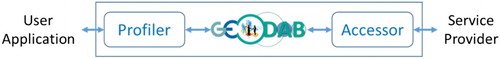
It should be pointed out that efforts on addressing the above need and challenges related to LCC resources sharing, community-oriented services and cross-border collaboration have already been undergone. An example is the Global Earth Observation System of Systems (GEOSS). As a ‘system of systems’, GEOSS has become a central part of the GEO mission over the past years. One of its tasks is to connect Earth observation resources, including land cover datasets and information services, with GEOSS Portal as an entry point to Earth observation data that allows discovery, access and contribution of Earth observation data and services. To facilitate the development of GEOSS, GEO has developed the Discovery and Access Broker (DAB), a brokering framework, under the GEOSS Common Infrastructure (GCI) (Nativi et al. Citation2015). The purpose of DAB is to provide a broker middleware to separate users from providers of services (). The idea is to keep the core of DAB independent of user applications’ and service providers’ systems, leaving the necessary interaction burden to so called ‘profiler’ and ‘accessor’.
Figure 1. Concept of the DAB.
Both GEOSS portal and DAB of the GCI relies on resources, including datasets and services, published by providers and supply systems. However, as of 13 April 2016 a quick search of ‘land cover’ shows only 2294 entries, and most of them are simple data descriptions without direct downloading links and map services of the found datasets. It is therefore becoming a crucial for GEO community to encourage more data producers or providers to actively register their data and products, as well as their data and processing services to make the whole system work. While registering data holdings may require less effort to so, developing, providing and hosting web services for datasets will need substantial investment and efforts on data holders’ side. Fortunately, there are many open source and commercial tools or platforms as service platforms, which data holders can utilize to develop their web/cloud services easier.
4. A conceptual framework of CoGland
With the significant advances in the field of earth observations, geo-web science technologies and SOC, it is now the time and feasible to develop a collaborative infrastructure for discovering, accessing, sharing and serving LCC information through cross-border and trans-disciplinary collaboration.
4.1. The nature
The vision of the CoGland is to enable timely and easy access to LCC data and information services through cooperatively inter-connecting national, regional and global LCC information service systems, and public and private data providers. It aims at increasing access to and sharing of LCC data and information services over the Web, by gathering a variety of LCC datasets, data products and information services into a single, ‘one stop’ web interface (i.e. a portal). It will enable:
data users, developers and suppliers to find, evaluate, access, visualize and publish LCC data products and web services;
personalized, single point of access to LCC information resources;
access to a range of heterogeneous web services for resource discovery, data processing and analysis, online collaboration, etc.; and
dynamic service computing that can incorporate numerous models and algorithms that facilitate more practical applications.
CoGland takes full advantage of the Web and more recent cloud computing, and follows the basic WWW principles and related standards (e.g. ISO and OGC standards on geospatial web services) for its development. Web-based and cost-free, among others, are two criteria that make any land cover data tools useful (Watermolen Citation2008). In particular, CoGland keeps the following principles in its design and development:
Open and shared access: promote the use of open source technologies, the share of available resources and participation of all stakeholders;
Standard based: follow all existing internationally-recognized standards;
Encourage cooperation: adopt the concepts of co-design, co-development and co-operation, and develop meaningful cooperation agreements and policies; and
Service-driven: use state-of-the-art service-oriented technologies.
Different from other systems and platforms such as GEO GEOSS, CoGland focuses on serving LCC information. It integrates LCC data, information and processing services provided by other systems and crawled from the Web to provide a single access point. This calls for the integration of all available resources, that can provide data, information, services, applications and policy support, and that develops common information exchange standards, build capacity, and enhance partnerships among LCC information providers and users.
4.2. Components
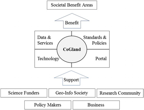
Collaboration is the key of CoGland’s design and implementation. The first step is to develop a common vision as described in Section 4.1. CoGland involves: (1) geo-information societies (e.g. data producers and service providers) who provide data and information services; (2) research groups who engage in developing required methods and tools; (3) funding agencies who will be approached for support of international collaborative projects on CoGland; (4) policy makers who will assist in forming cooperation policies and agreements and (5) business communities who may benefit from CoGland economically and provide feedback for improving services. illustrates the collaborative framework that includes all these components and describes the relationships between them.
Figure 2. Collaborative framework of CoGland.
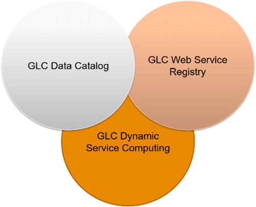
The core component of CoGland includes data and services, technology, standards and policies and portal. Data are essential, but CoGland does not attempt to hold all LCC data, data products and services. It establishes ways to link to the data and services distributed over the Internet and various organizations. As such, LCC data catalogue and web service registry are two essential elements, as shown in . The technology component looks into all hardware, software, networks, databases and technical implementation plans that support CoGland development, in particular, open source based web service technologies (Brovelli et al. in this issue), GEO GCI developments, and dynamic service computing technologies.
Figure 3. Data and services of CoGland.
The standards and policies component develops standards and policies about data use, production, validation and services, data sharing, governance and partnerships. Existing standards and policies from ISO, OGC, GEOSS, ICSU, etc. should be studied. For example, ICSU proposed to address data policies in four major areas including documentation and quality, preservation, access and dissemination, and costs (ICSU Citation2013).
The last core component of CoGland is a portal that takes care of the front-end interface with end users. It follows a horizontal portal design to provide access to CoGland’s capabilities of search and navigation, data integration, personalization, notification, workflow, collaboration and groupware, and service integration. More details are discussed in the next section.
4.3. Conceptual architecture of the portal
Parallel to other core components shown in , the development of a web-based portal is the key and the first step towards full-fledged implementation of CoGland. The portal acts as the ‘one stop’ web interface that allows users to interact with the content and functionality provided through the development of other core components, and in turn make use of shared LCC resources for different applications with the support of multi-stakeholders. As a starting point for the portal development, it should provide at least:
a metadata catalogue that enables data users, developers and suppliers to find, evaluate, access, visualize and publish GLC data products and web services.
a personalized, single point of access to LCC resources that support end users in one or more tasks (information discovery, data processing, analysis, etc.).
access to a range of heterogeneous network services in an interoperable manner, local and remote, structured and unstructured, such as LCC resource discovery services, data processing and analysis services, online discussion, collaborative data editing and validation wiki, etc.
capability of dynamic LCC service computing to facilitate better application workflows of LCC information.
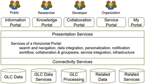
shows the conceptual architecture of the CoGland portal, which connects to various data and processing services and provides personalized portals for different types of users.
Figure 4. Architecture of CoGland portal.
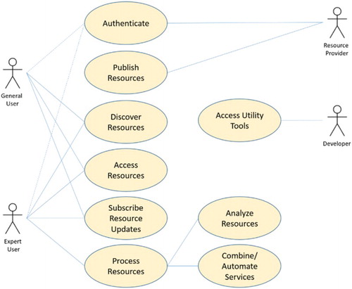
People who interact with the CoGland portal fall into two groups: users (general user and expert user) and providers (resource provider and developer). The general users mainly discover and access resources while expert users extract knowledge by using analysis and service automation tools, that is, the second group of users can perform some spatio-temporal and geo-statistical analysis of LCC data, and composite data and processing services into an automatically executable workflow. The expert users may also participant in online collaboration by accessing groupware tools, for example, performing data validation. Both groups of users can subscribe/receive notifications of data and service updates. The resource providers publish data sources and services while developers may access utility tools that help them to establish data and processing services to be published. shows the high-level use cases that depict the interaction between people and the portal.
Figure 5. Use cases of CoGland portal.
5. Implementation strategies
Given the collaborative nature of CoGland, it should be developed and implemented by following a co-design and co-development approach and operated through co-operation by its stakeholders. A roadmap is proposed (as shown in ) with three aspects of CoGland implementation: (1) participation mobilization, (2) platform development, and (3) legal and governance. These aspects are further described below.
Figure 6. CoGland roadmap.
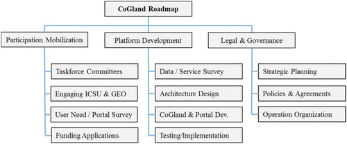
5.1. Participation mobilization
Participation Mobilization aims at building shared understanding within GLC information and its user communities by engaging them through taskforce committees, user need surveys and open dialogues. Specially, as discussed in 2015 ISPRS/GEO Beijing workshop (ISPRS Citation2015), the survey of user needs may be a key for fully understanding what should be served by the portal. Close collaboration with organizations such as GEO and the United Nations Expert Committee on Global Geospatial Information Management (UN-GGIM) will provide great facilitation to this survey. Collaborative research projects funded by international organizations such as ICSU, which support networking and capacity building, are also good vehicle for mobilizing international participation in CoGland development.
5.2. Platform development
Platform development is the key to ensure successful CoGland implementation. Key tasks include existing LCC data and service inventory and active discovery of future new datasets and services, portal design and development, and coordinated testing of the portal to guaranty its usability.
The CoGland portal is similar to the GEOSS Community Portal that is defined as ‘a community-focused portal (website) that provides a human user interface to content that may be accessed from distributed resources’ (http://www.ogcnetwork.net/node/1926). To leverage on the data, data services and data portals registered in GEOSS portal, DAB of GIC, and the GEO’s model web initiative, it is a good strategy to implement the CoGland portal as a GEO Community Portal. Here, the implementation of the model web concept enables new services being developed based on numerous land cover analysis models, which helps capacity building of LCC information services. illustrates a conceptual architecture of such an implementation.
Figure 7. Architecture of the CoGland portal as a GEO community portal.
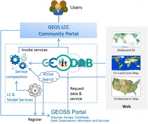
The implementation of the GEO GLC Community Portal follows ‘GEOSS Recommendations for Community Portals’ within the GEOSS framework (GEO Citation2013). The portal interacts with GEOSS to discover, access, visualize and publish land cover related resources. It further provides processing and automation services through dynamic service computing by compositing data and domain model services in well-coordinated workflows. The GEO LCC Community Portal, with a focus on LC data, information and services, will improve and/or complement the existing capabilities of the GEOSS Portal by offering and/or developing: (1) different types of specialized portal services (including model services), (2) active search for LCC data and processing services, (3) LCC service standards and (4) capabilities in performing dynamic LCC computing tasks based on services.
5.3. Legal and governance
Legal and Governance focuses on strategic planning for long-term operation of the platform, organizational and coordination agreements, institutional frameworks, acceptable use policies, funding and other matters. After some formal and informal discussions and communications, GEO is believed to be an excellent liaison for coordinating activities in this aspect.
6. Concluding remarks
It was at the ISPRS/GEO workshop, held in Beijing, 9–10 June 2015, that the trend of developing a GLC information service was intensively discussed and the CoGland was proposed to GEO and ICSU as a scientific initiative. This paper summarized the results from the workshop, presents the concept of the CoGland initiative. It further discusses that how this initiative may be realized through international collaboration and utilization of the state-of-the-art technologies. The purpose is to provide an overview of all aspects of the proposed CoGland to encourage further open discussions within the GLC communities by data producers, information service developers and users. This will help the GLC community to reach consensus and to make an action plan for its implementation in the coming few years.
With the significant technological advances in the field of SOC and geo-processing, it is now feasible to develop the proposed CoGland. From the implementation point of view, there are a number of technical issues to be solved, such as creation of networked resources and virtual organization, automated cross-ontology translation, flexible deployment and re-use of processing algorithms and analysis models, interoperable data tools and services. In addition, development of new visualization and animation services is needed for deriving knowledge from the big LCC datasets and make it visible and understandable to the users.
In summary, the question now is no longer whether a GLC information service is necessary. Rather, it is challenging how such a collaborative service can be developed to respond the increasing need for supporting the SBAs and sustainable development goals. With the existing and emerging technology advances and current pilot projects by a number of countries, especially by leveraging on GIC, it is expected that substantial progress will be made in the next 5–10 years. Clearly, the coordination role played and contributions made by some key international organizations such as GEO, UN-GGIM, ISPRS and ISDE are important to such progress.
Acknowledgements
The authors wish to thank Maria Antonia Brovelli, Ian Dowman, Mario Hernandez, Zhilin Li, Chuang Liu, Brice Mora, André Obregón, Yuqi Bai and Qian Ye for their valuable commentary contributions, and anonymous reviewers for their constructive comments, which helped improve the paper.
Disclosure statement
No potential conflict of interest was reported by the authors.
Additional information
Funding
References
- Ahmed, M., D. Wickramasinghe, and T. T. Vu. 2015. “Towards Landcover Classification Service on Cloud”, the University of Nottingham, UK. Accessed 15 November 2016. https://prezi.com/qktnytd7pk7z/towards-landcover-classification-service-on-cloud/.
- Ban, Y., P. Gong, and C. Giri. 2015. “Global Land Cover Mapping Using Earth Observation Satellite Data: Recent Progresses and Challenges.” ISPRS Journal of Photogrammetry and Remote Sensing 103 (2015): 1–6. doi: 10.1016/j.isprsjprs.2015.01.001
- Brovelli, M. A., F. C. Fahl, M. Minghini, and M. E. Molinari. 2016. “Land Use and Land Cover Maps of Europe: A Webgis Platform.” ISPRS-International Archives of the Photogrammetry, Remote Sensing and Spatial Information Sciences, 2016: 913–917.
- Brovelli, M. A., M. E. Molinari, E. Hussein, J. Chen, and R. Li. 2015. “The First Comprehensive Accuracy Assessment of GlobeLand30 at a National Level: Methodology and Results.” Remote Sensing 7 (4): 4191–4212. doi: 10.3390/rs70404191
- Candela, L., D. Castelli, G. Coro, L. Lelii, F. Mangiacrapa, V. Marioli, and P. Pagano. 2015. “An Infrastructure-oriented Approach for Supporting Biodiversity Research.” Ecological Informatics 26: 162–172. doi: 10.1016/j.ecoinf.2014.07.006
- CCI. 2016. “CCI-LC Product User Guide.” Accessed 18 November 2016. http://maps.elie.ucl.ac.be/CCI/viewer/download/ESACCI-LC-PUG-v2.5.pdf.
- Chen, J., J. Chen, X. Cao, A. Liao, X. Cao, L. Chen, X. Chen, et al. 2015. “Global Land Cover Mapping at 30 m Resolution: A POK-based Operational Approach.” ISPRS Journal of Photogrammetry and Remote Sensing 103 (2015): 7–27. doi: 10.1016/j.isprsjprs.2014.09.002
- Chen, J., L. Chen, and R. Li. 2015. “Spatial Distribution and Ten Year’s Change of Global Built-up Areas Derived from GlobeLand30.” Acta Geodaetica et Cartographica Sinica 44 (11): 1181–1188.
- Chen, X., J. Chen, Y. Shi, and Y. Yamaguchi. 2012. “An Automated Approach for Updating Land Cover Maps Based on Integrated Change Detection and Classification Methods.” ISPRS Journal of Photogrammetry and Remote Sensing 71 (2012): 86–95. doi: 10.1016/j.isprsjprs.2012.05.006
- Chen, F., J. Chen, H. Wu, D. Y. Hou, W. W. Zhang, J. Zhang, X. G. Zhou, and L. J. Chen. 2016. “A Landscape Shape Index-based Sampling Approach for Land Cover Accuracy Assessment.” Science China Earth Sciences 59: 1–12.
- Chen, J., I. Dowman, S. Li, Z. Li, M. Madden, J. Mills, N. Paparoditis, et al. 2016. “Information from Imagery: ISPRS Scientific Vision and Research Agenda.” ISPRS Journal of Photogrammetry and Remote Sensing 115 (2016): 3–21. doi: 10.1016/j.isprsjprs.2015.09.008
- Chen, J., H. Wu, S. Li, F. Chen, and G. Han. 2013. “Service Oriented Dynamic Computing for Land Cover Big Data.” Journal of Geomatics Science and Technology 30 (4): 369–374.
- Diogo, V., and E. Koomen. 2016. “Land Cover and Land Use Indicators: Review of Available Data”, OECD Green Growth Papers, No. 2016/03, OECD Publishing, Paris.
- Foley, J., D. Ruth, G. P. Asner, C. Barford, G. Bonan, S. R. Carpenter, F. S. Chapin, et al. 2005. “Global Consequences of Land Use.” Science 309 (5734): 570–574. doi: 10.1126/science.1111772
- Foster, I. 2005. “Service-oriented Science.” Science 308 (5723): 814–817. doi: 10.1126/science.1110411
- Fritz, S., I. McCallum, C. Schill, C. Perger, L. See, D. Schepaschenko, M. van der Velde, F. Kraxner, and M. Obersteiner. 2012. “Geo-Wiki: An Online Platform for Improving Global Land Cover.” Environmental Modelling & Software 31: 110–123. doi: 10.1016/j.envsoft.2011.11.015
- GEO. 2013. “GEOSS Recommendations for Community Portals (Version 0.0.1).” Accessed 18 November 2016. https://portal.opengeospatial.org/files/?artifact_id=56042. Accessed 10 April 2016.
- Gong, P., L. Yu, C. Li, J. Wang, L. Liang, X. Li, L. Ji, Y. Bai, Y. Cheng, and Z. Zhu. 2016. “A New Research Paradigm for Global Land Cover Mapping.” Annals of GIS 22 (2): 87–102. doi: 10.1080/19475683.2016.1164247
- Grekousis, G., G. Mountrakis, and M. Kavouras. 2015. “An Overview of 21 Global and 43 Regional Land-cover Mapping Products.” International Journal of Remote Sensing 36 (21): 5309–5335. doi: 10.1080/01431161.2015.1093195
- Han, G., J. Chen, C. He, S. Li, H. Wu, A. Liao, and S. Peng. 2015. “A Web-based System for Supporting Global Land Cover Data Production.” ISPRS Journal of Photogrammetry and Remote Sensing 103: 66–80. doi: 10.1016/j.isprsjprs.2014.07.012
- Han, W., Z. Yang, L. Di, and R. Mueller. 2012. “CropScape: A Web Service Based Application for Exploring and Disseminating US Conterminous Geospatial Cropland Data Products for Decision Support.” Computers and Electronics in Agriculture 84: 111–123. doi: 10.1016/j.compag.2012.03.005
- Han, W., Z. Yang, L. Di, B. Zhang, and C. Peng. 2014. “Enhancing Agricultural Geospatial Data Dissemination and Applications Using Geospatial Web Services.” IEEE Journal of Selected Topics in Applied Earth Observations and Remote Sensing 7 (11): 4539–4547. doi: 10.1109/JSTARS.2014.2315593
- Herold, M., R. Hubald, and A. Di Gregorio. 2009. “Translating and Evaluating the Land Cover Legends Using the UN Land Cover Classification System (LCCS).” GOFC-GOLD Report No. 43.
- Hou, D., J. Chen, and H. Wu. 2016. “Discovering Land Cover Web Map Services from the Deep Web with JavaScript Invocation Rules.” ISPRS International Journal of Geo-information 5 (7): 105. doi: 10.3390/ijgi5070105
- Hou, D., J. Chen, H. Wu, S. Li, F. Chen, and W. Zhang. 2015. “Active Collection of Land Cover Sample Data from Geo-tagged Web Texts.” Remote Sensing 7 (5): 5805–5827. doi: 10.3390/rs70505805
- ICSU. 2013. “Future Earth Initial Design: Report of the Transition Team.” Paris: International Council for Science (ICSU). Accessed 18 November 2016. http://www.icsu.org/future-earth/media-centre/relevant_publications/future-earth-initial-design-report.
- ISPRS. 2015. “Report on the International Workshop on Supporting Future Earth with Global Geo-information.” ISPRS e-Bulletin, Issue No. 3. Accessed 18 November 2016. http://119.90.25.43/www.isprs.org/news/newsletter/2015-03/53_Report_on_Beijing_Workshop.pdf.
- IUFRO. 2005. “Development of a Global Forest Information Service (GFIS) as a CPF Initiative” GFIS Working Paper 1, Global Forest Information Service, February 1. Accessed 1 October 2016. https://www.gfis.net/gfis/pdf/policy-paper-initiative.pdf.
- IUFRO. 2009. “Strategic Plan – Sharing Forest Information Around the World” GFIS Working Paper 16, Global Forest Information Service, November 19. Accessed 1 October 2016. http://www.gfis.net/gfis/pdf/GFIS_WP16.pdf.
- Latifovic, R., R. Fernandes, D. Pouliot, and I. Olthof. 2015. “Characterization and Monitoring Change of Canada’s Land Surface.” Natural Resources Canada. Accessed 18 November 2016. http://www.nrcan.gc.ca/earth-sciences/land-surface-vegetation/land-cover/north-american-landcover/9146.
- Li, S., C. Xiong, and Z. Ou. 2011. “A Web GIS for Sea Ice Information and an Ice Service Archive.” Transactions in GIS 15 (2): 189–211. doi: 10.1111/j.1467-9671.2011.01250.x
- Liu, X., S. Li, W. Huang, and J. Gong. 2015. “Designing Sea Ice Web APIs for Ice Information Services.” Earth Science Informatics 8 (3): 483–497. doi: 10.1007/s12145-015-0207-5
- Lu, D., G. Li, and E. Moran. 2014. “Current Situation and Needs of Change Detection Techniques.” International Journal of Image and Data Fusion 5 (1): 13–38. doi: 10.1080/19479832.2013.868372
- Meyer, W. B., and B. Turner. 1994. Changes in Land Use and Land Cover: A Global Perspective. Cambridge: Cambridge University Press.
- Mölders, N. 2011. Land-use and Land-cover Changes: Impact on Climate and Air Quality (Vol. 44). Dordrecht: Springer.
- Mora, B., N. E. Tsendbazar, M. Herold, and O. Arino. 2014. “Global Land Cover Mapping: Current Status and Future Trends.” In Land Use and Land Cover Mapping in Europe: Practices & Trends, edited by Ioannis Manakos and Matthias Braun, 11–30. Dordrecht: Springer.
- Mwaniki, W. M., and S. M. Möller. 2015. “Knowledge Based Multi-source, Time Series Classification: A Case Study of Central Region of Kenya.” Applied Geography 60: 58–68. doi: 10.1016/j.apgeog.2015.03.005
- Nativi, S., P. Mazzetti, M. Craglia, and N. Pirrone. 2014. “The GEOSS Solution for Enabling Data Interoperability and Integrative Research.” Environmental Science and Pollution Research 21 (6): 4177–4192. doi: 10.1007/s11356-013-2264-y
- Nativi, S., P. Mazzettia, M. Santoroa, F. Papeschia, M. Cragliab, and O. Ochiaic. 2015. “Big Data Challenges in Building the Global Earth Observation System of Systems.” Environmental Modelling & Software 68: 1–26. doi: 10.1016/j.envsoft.2015.01.017
- O’Connor, B., C. Secades, J. Penner, R. Sonnenschein, A. Skidmore, N. D. Burgess, and J. M. Hutton. 2015. “Earth Observation as a Tool for Tracking Progress Towards the Aichi Biodiversity Targets.” Remote Sensing in Ecology and Conservation 1 (1): 19–28. doi: 10.1002/rse2.4
- Oleson, L. R. 1993. “The Global Land Information System.” Paper presented at AIP Conference on the Earth and Space Science Information System, Pasadena, February.
- Pettit, C.J., R. Tanton, and J. Hunter. in press. “An Online Platform for Conducting Spatial-statistical Analyses of National Census Data Across Australia.” Computers, Environment and Urban Systems.
- Ramankutty, N., L. Graumlich, F. Achard, D. Alves, A. Chhabra, R. S. DeFries, J. A. Foley, et al. 2006. “Global Land-cover Change: Recent Progress, Remaining Challenges.” In Land-use and Land-cover Change, 9–39. Berlin: Springer.
- Reid, W. V., D. Chen, L. Goldfarb, H. Hackmann, Y. T. Lee, K. Mokhele, E. Ostrom, et al. 2010. “Earth System Science for Global Sustainability: Grand Challenges.” Science 330 (6006): 916–917. doi: 10.1126/science.1196263
- Scott, G., and A. Rajabifard. 2015. “Integrating Geospatial Information into the 2030 Agenda for Sustainable Development.” Paper presented at the 20th United Nations Regional Cartographic Conference for Asia-Pacific Jeju Island, Republic of Korea, October 6–9.
- See, L., C. Perger, M. Hofer, J. Weichselbaum, C. Dresel, and S. Fritz. 2015. “LACO-WIKI: An Open Access Online Portal for Land Cover Validation.” ISPRS Annals of Photogrammetry, Remote Sensing and Spatial Information Sciences II-3/W5: 167–171. doi: 10.5194/isprsannals-II-3-W5-167-2015
- Suresh, S. 2012. “Research Funding: Global Challenges Need Global Solutions.” Nature 490 (7420): 337–338. doi: 10.1038/490337a
- Tsendbazar, N. E., S. de Bruin, and M. Herold. in press. “Integrating Global Land Cover Datasets for Deriving User-specific Maps.” International Journal of Digital Earth.
- Verburg, P. H., K. Neumann, and L. Nol. 2011. “Challenges in Using Land Use and Land Cover Data for Global Change Studies.” Global Change Biology 17 (2): 974–989. doi: 10.1111/j.1365-2486.2010.02307.x
- Watermolen, D. 2008. “Land Cover Data and Tools for Analyzing Alternative Futures: One State’s Lessons Learned.” In North America Land Cover Summit, edited by J. C. Campbell, K. B. Jones, J. H. Smith, and M. T. Koeppe, 293–330. Washington, DC: Association of American Geographers.
- Xian, G., H. Collin, and J. Fry. 2009. “Updating the 2001 National Land Cover Database Land Cover Classification to 2006 by Using Landsat Imagery Change Detection Methods.” Remote Sensing of Environment 113 (6): 1133–1147. doi: 10.1016/j.rse.2009.02.004
- Xing, H., J. Chen, H. Wu, J. Zhang, and B. Liu. 2016. “An Online Land Cover Change Detection System with Web Service Composition.” Paper presented in the 4th International Workshop on Earth Observation and Remote Sensing Applications 2016: 275–279.
- Xing, H., J. Chen, and X. Zhou. 2015. “A Geoweb-based Tagging System for Borderlands Data Acquisition.” ISPRS International Journal of Geo-Information 4 (3): 1530–1548. doi: 10.3390/ijgi4031530
- Yue, K., X. Wang, and A. Zhou. 2004. “Underlying Techniques for Web Services: A Survey.” Journal of Software 15 (3): 428–442.
- Zhang, W. W., J. Chen, A. P. Liao, G. Han, X. Chen, L. J. Chen, S. Peng, H. Wu, and J. Zhang. 2016. “Geospatial Knowledge-based Verification and Improvement of GlobeLand30.” Science China Earth Sciences 59 (9): 1709–1719. doi: 10.1007/s11430-016-5318-4
- Zhang, R., and Y. Zhou. 2009. “From Resource Sharing to Service Sharing: Opportunities and Challenges of Transparent Computing.” Engineering Sciences 11 (8): 10–17.