
ABSTRACT
China has experienced unprecedented urbanization in the past decades, resulting in dramatic changes in the physical, limnological, and hydrological characteristics of lakes in urban landscapes. However, the spatiotemporal dynamics in distribution and abundance of urban lakes in China remain poorly understood. Here, we characterized the spatiotemporal change patterns of urban lakes in China’s major cities between 1990 and 2015 using remote-sensing data and landscape metrics. The results showed that the urban lake landscape patterns have experienced drastic changes over the past 25 years. The total surface area of the urban lakes has decreased by 17,620.02 ha, a decrease of 24.22%, with a significant increase in the landscape fragmentation and a reduction in shape complexity. We defined three lake-shrinkage types and found that vanishment was the most common lake-shrinkage pattern, followed by edge-shrinkage and tunneling in terms of lake area. Moreover, we also found that urban sprawl was the dominant driver of the lake shrinkage, accounting for 67.89% of the total area loss, and the transition from lakes to cropland was also an important factor (19.86%). This study has potential for providing critical baseline information for government decision-making in lake resources management and urban landscape design.
1. Introduction
Inland water bodies, especially lakes, acting as sentinels and regulators of climate change, play an important role in the global environment, by providing habitat for a wide range of species and forming essential components in hydrological, nutrient, and carbon cycles (Tranvik et al. Citation2009; Feng et al. Citation2016; Carroll et al. Citation2009; Carroll and Loboda Citation2017). However, Earth’s surface is suffering from extensive land-use/cover changes under climate change and anthropogenic activities, resulting in dramatic changes in the distribution and abundance of lakes all over the world (Gao et al. Citation2011; Smith et al. Citation2005; Ma et al. Citation2010; Cael and Seekell Citation2016; Liao, Shen, and Li Citation2013). In the meantime, urbanization, a major anthropic alteration of the Earth’s surface, also poses increasingly significant threats to the global lake resources. More than 50% of the global population lives in urban areas in 2014 (United Nations Citation2014), leading directly to the increasing demand for water resources. However, the unprecedented urbanization has exerted enormous pressures on water resources, especially the lakes in urban areas (Naselli-Flores Citation2008). Coordinating the conflict between lake conservation and human demand for water resources remains a task for urban development.
Urban lakes, whether natural or man-made, are vitally important components of the water resource in the cities, which tend to be shallow, small, and highly artificial in comparison with other non-urban lakes (Birch and McCaskie Citation1999). Although occupying a small proportion of the world’s lake resources, urban lakes play a significant role in urban ecosystem and human life. Urban lakes are essential elements of urban systems as well as ecological networks, which significantly contribute to environmental, social, and economic functions in urban areas, such as water supply, flood control, species habitat, and microclimate moderation (Birch and McCaskie Citation1999; Hamer and Parris Citation2011). Despite the ecological and social importance, the spatial and temporal dynamics of the urban lakes and landscape pattern in response to the rapid urbanization are still not well understood.
Given the high population density in urban areas, urban lakes are under the direct impacts of human activities, and as a result are considered as one of the most vulnerable freshwater ecosystems in the world (Birch and McCaskie Citation1999; Steele and Heffernan Citation2014). Due to this high level of human disturbance, especially in a densely populated country such as China, urban lakes vary greatly in terms of spatial distribution, abundance, and ecological function. To meet the needs of growing urban population, China has experienced an accelerated expansion of cities since the 1978 implementation of economic reforms (Chen Citation2007). Within this broad context, China’s urban lakes have been seriously influenced by the intensive land-use changes triggered by rapid urban sprawl and population growth. The lakes in cities have been facing intensive human disturbances via construction, burial, drainage, and reshaping, which have created various negative impacts on the quality and functions of lakes (Du, Ottens, and Sliuzas Citation2010; Steele and Heffernan Citation2014). Consequently, the conflict between rapid urbanization and the maintenance of urban lakes in China urgently needs to be addressed (Liu et al. Citation2007).
There has been a long-standing concentration of research efforts on natural or semi-natural lakes in China (Liu et al. Citation2013; Sun et al. Citation2014; Ma et al. Citation2010; Yang and Lu Citation2014; Mei et al. Citation2015; Liao, Shen, and Li Citation2013; Li et al. Citation2016), but very little attention has been paid to the urban lakes. Existing studies have primarily focused on (i) changes in the distribution and abundance of urban lakes and the associated impacts of land-use changes (Steele and Heffernan Citation2014; Du, Ottens, and Sliuzas Citation2010; Liu et al. Citation2007), (ii) water quality deterioration due to intensive human activity (Ren et al. Citation2003; Wang et al. Citation2016; Novotny, Murphy, and Stefan Citation2008; Zeng et al. Citation2009; Birch and McCaskie Citation1999), and (iii) the effects of water bodies on urban environment, such as mediating local microclimates (Sun and Chen Citation2012; Sun et al. Citation2012; Steeneveld et al. Citation2014; Du et al. Citation2016). However, most previous studies have been conducted either at the individual lake level or at the single city level. Overall, the spatial distribution, abundance, and landscape change of the lakes in urban areas across China remained unexplored. Given the rapid growth in the urban areas and population in China, understanding the spatiotemporal change pattern of urban lakes as well as the associated driving factors is an essential foundation for urban water management and landscape design (Steele and Heffernan Citation2014).
In this study, we first performed a dynamic analysis of the landscape spatiotemporal pattern of urban lakes in China’s 32 major cities between 1990 and 2015. The objectives of this study were (i) to map the spatial and temporal dynamics of urban lakes in the 32 cities, (ii) to characterize and compare their changes of landscape characteristics, and (iii) to quantify the contributions of the human-induced driving factors.
2. Data and methods
2.1. Study areas and data
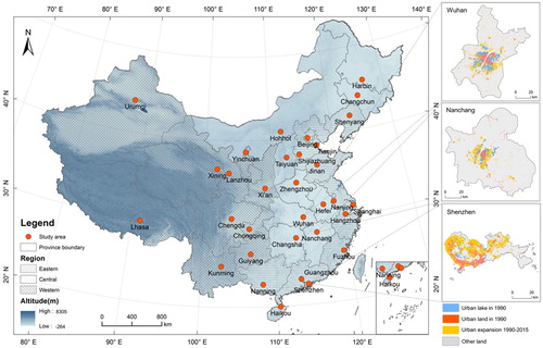
Our study focused on 32 major cities in China, which mainly include provincial capitals, municipalities, and autonomous regions. Most of these cities are the cultural, economic, and industrial focal point of China’s major provinces. Although the 32 cities differ in history, demographics, and economics, they have experienced dramatic economic growth and landscape changes between 1990 and 2015. Concomitant with rapid urban and economic development, a vast number of natural lands, especially lakes, streams, and wetland in urban or peri-urban areas, have been depleted by the urbanization process. Thus, a quantitative landscape change analysis was conducted to characterize the spatiotemporal dynamics of urban lakes in the 32 cities. To compare and analyze the spatial distribution, abundance, and change patterns of the urban lakes among different regions and cities, a broad regionalization scheme that divides China into eastern, central, and western regions was used (Lin Citation2002), including 13, 9, and 10 cities in this study, respectively.
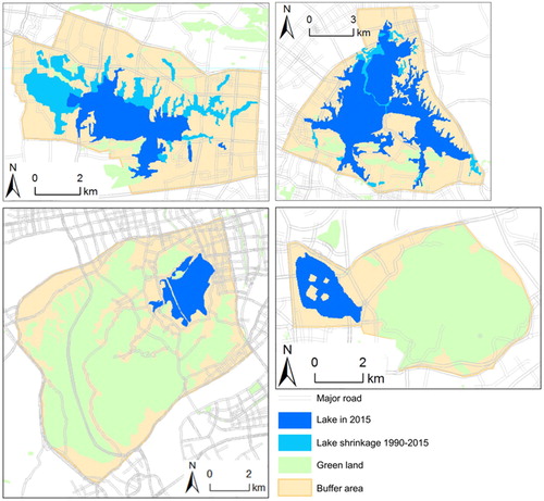
We employed the China land use/cover dataset (CLUD), a national land-use/cover change database (http://www.resdc.cn/), to identify and analyze the spatiotemporal patterns of urban lake changes between 1990 and 2015. This dataset is a national high-resolution database (spatial resolution: 30 m × 30 m) developed by the Chinese Academy of Sciences based on the integration of remote sensing and geographical information systems (GIS) technology. Two periods of the CLUD dataset (1990 and 2015) used in this study were generated by visual interpretation and digitalization of more than 500 Landsat TM/ETM/OLI and HJ-1A/1B scenes covering the entire nation (Liu et al. Citation2005; Zhuang, Liu, and Liu Citation1999). A hierarchical classification system was established in this dataset, including 6 classes (cropland, forest, grassland, water bodies, built-up land, and unused land) and 25 subclasses. The detailed description of each land-use class can be found in the previous studies (Liu et al. Citation2005). According to the nationwide field surveys, the average interpretation accuracy was 92.9% for 1990, and more than 94.3% for 2015 (Liu et al. Citation2014; Liu et al. Citation2005; Liu et al. Citation2017). Specifically, urban built-up areas (including residential, commercial, transportation, and industrial land in cities), and the associated urban lakes for the two dates (1990 and 2015) were derived from the CLUD database. In addition, visual inspection with reference to Google Earth images, published literature, and field investigations were conducted to help refine lake boundaries. shows the spatial distribution of urban areas and urban lakes of the 32 cities.
Figure 1. Spatial distribution of 32 major cities in China, with the background map indicating the topography of China. The three geographic divisions in China (eastern, central, and western regions) are illustrated. Urban expansion between 1990 and 2015, and the associated urban lakes in Wuhan, Nanchang, and Shenzhen are highlighted.
2.2. Landscape metrics
To quantify the landscape change patterns of urban lakes, we selected six most commonly used landscape metrics (Seto and Fragkias Citation2005; Fang, Li, and Wang Citation2016; Kaza Citation2013), including total lake area (CA), number of lake patches (NP), mean patch size (MPS), edge density (ED), area-weighted mean shape index (AWMSI), and area-weighted mean patch fractal dimension (AWMPFD). The chosen landscape metrics were used to describe four aspects of the urban lakes: absolute size, relative size, edge metrics, and complexity of urban lakes (). The total lake area (CA) in city could tend to decrease due to the continuous expansion of urban space, but may increase if new man-made lakes are constructed. An increase in NP may be a symbol of subdivisions of urban lake landscape. Relative size is characterized by MPS, defined as the ratio of the size of urban lakes to the number of lake patches. It is generally recognized that a decrease in MPS mirrors a trend toward fragmentary landscape of urban lakes. ED measures the total edge of urban lakes relative to the total landscape. A high value of ED implies that the level of contiguity for urban lake landscape decreased. In practice, the combination of the MPS and ED is recommended for the analysis of landscape fragmentation (Tyler and Peterson Citation2004). AWMSI and AWMPFD describe the landscape complexity of urban lakes. An increase in the value of the two metrics indicates that the shape of urban lakes becomes more irregular and complex.
Table 1. Landscape metrics of urban lakes used in this study.
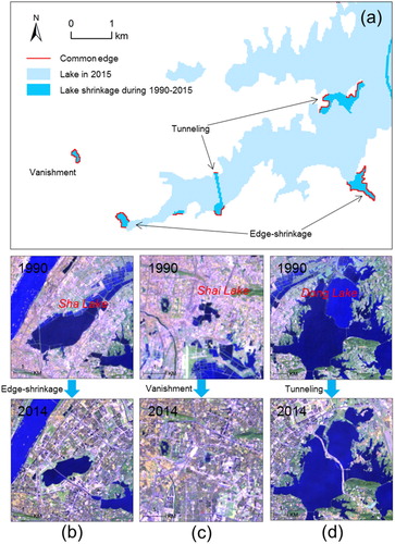
2.3. Three lake shrinkage types
Similar to urban growth type index (Xu et al. Citation2007; Chen, Gao, and Yuan Citation2016), three lake-shrinkage types (vanishment, edge-shrinkage, and tunneling) were defined in this study to measure the shrinkage patterns and processes of urban lakes. Vanishment denotes that an existing lake patch has disappeared; edge-shrinkage refers to the fringe of an existing lake being converted to non-lake area; tunneling indicates that an urban lake may be segmented by artificial features, such as road construction. The lake-shrinkage-type index (LSTI) was used to identify the three shrinkage patterns:where
denotes the perimeter of a newly shrinking lake patch,
indicates the length of the common edge of this newly shrinking lake patch and existing lake patch. The value of LSTI ranges from 0 to 1. The lake-shrinkage type is identified as vanishment when LSTI = 1, as edge-shrinkage when 0.5 ≤ LSTI < 1, and as tunneling when 0 < LSTI < 0.5. The three shrinkage patterns are illustrated in .
Figure 2. (a) Illustration of the three lake-shrinkage types. (b), (c), and (d) are the Landsat images (2 September 1990 and 6 October 2014) of three typical urban lakes, that is, Sha Lake (edge-shrinkage), Shai Lake (vanishment), and Dong Lake (tunneling), respectively. The Landsat images were obtained from the United States Geological Survey (USGS; http://www.usgs.gov/).
3. Results
3.1. Landscape change pattern of urban lakes
With the rapid growth of human population, China has been experiencing unprecedented urban land expansion, resulting in drastic changes in spatiotemporal patterns of urban lake landscape between 1990 and 2015 (). Collectively, the total urban land area of the 32 cities expanded rapidly (approximately 2.31 times), while the total surface area of the associated urban lakes showed a significant decrease of 17,620.02 ha or 24.22% over the 25 years. To further understand the area changes in lakes, the temporal changes of the 20 typical lakes in the 3 cities (i.e. Wuhan, Nanchang, and Changsha) between 1990 and 2015 were investigated by using multiple land cover maps (CLUD). The relative lake area of the typical lakes for 6 periods (i.e. 1990, 1995, 2000, 2005, 2010, and 2015) and the overall trend of the area changes in these lakes are shown in . The total area of these typical lakes in Wuhan, Nanchang, and Changsha showed significant decreasing trends (p < .05).
Figure 3. Relative area changes of the 20 typical lakes in Wuhan (a), Nanchang (c), and Changsha (e). The relative lake area is calculated as .
is the surface area of the ith lake in one of these six periods and
indicates the surface area of the ith lake in the period of 1990. (b), (d), and (f) show the changing trends of the total area of these typical lakes in the three cities, respectively.
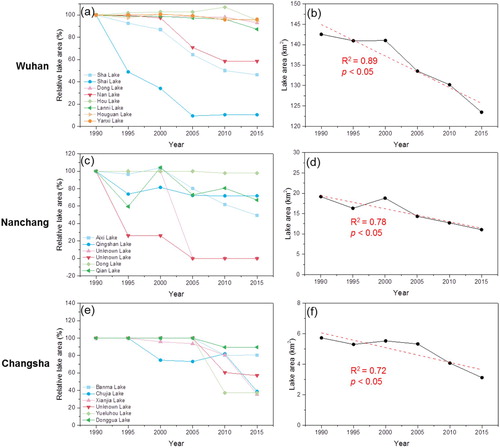
Table 2. Descriptive statistics of landscape metrics of urban lakes.
Accompanying the decrease in the surface area of lakes, a rapid reduction (30.5%) of the number of lake patches (NP) was also observed in the period of 1990–2015. This suggests that a large number of lake patches have disappeared. From a relative size perspective, the average lake patch size (MPS) increased by 3.60%, which indicates that the degree of fragmentation of lake patches decreased. This also reveals that many small lake patches have vanished, or new lake patches are larger than existing neighborhoods. However, the value of ED of urban lakes increased by 9.04% between 1990 and 2015, which is indicative of the increasing level of fragmentation of urban lakes during urbanization process. AWMSI and AWMPFD for total urban lakes showed a slight downward trend between 1990 and 2015. The values of the two metrics decreased by 4.63% and 0.48%, respectively, suggesting that urban lakes exhibit patterns of decreasing complexity in shape. The shape of urban lakes may provide a useful signature of the type and extent of alteration in cities. The physical reshaping of urban lakes due to intensive human activities may directly lead to a reduction in tortuosity and irregularity of their shorelines (Steele and Heffernan Citation2014).
3.2. Comparison of lake landscape patterns among various regions
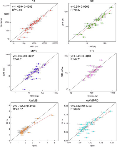
shows the overall spatiotemporal dynamics of landscape metrics of urban lakes in the 32 cities. A comparison analysis of urban lake landscape metrics between 1990 and 2015 is performed in . There is relative consistency for different landscape metrics between 1990 and 2015 (0.61 ≤ R2≤0.87, p < .05). Overall, the cities located in the middle and lower reaches of the Yangtze River (e.g. Wuhan, Nanchang, Nanjing, Hangzhou, and Changsha) had the largest surface area of urban lakes. Wuhan is known as ‘the city of a hundred lakes’ due to the dozens of lakes in the built-up areas (), and Tangxun Lake is the largest urban lake in China, with a surface area of 5259.15 ha. Comparatively, most cities in the semi-arid or arid areas of western China (e.g. Lanzhou, Xining, and Lhasa) had less urban lakes, with an area of less than 100 ha in 2015. Between 1990 and 2015, urban lakes in the western region decreased by 26.43% in area, whereas in central and eastern cities, they experienced an area reduction of 25.55% and 20.16%, respectively. In the case of NP, different changing patterns were found among the three regions compared to the lake surface area. The largest decline in the number of lake patches was observed in the eastern region (41.14%), followed by western region (34.75%) and central region (16.17%). Spatially, Beijing, Nanjing, Guangzhou, and Lanzhou were the primary focus areas with a large reduction of NP. Nevertheless, Shanghai witnessed the rapid growth of 45.45% in the number of lake patches owing to the construction of artificial lakes. For example, Dishui Lake, constructed as a landmark project in the main urban area of Shanghai Lingang New City, is the largest man-made freshwater lake existing in China, with a surface area of 423.06 ha.
Figure 4. Dynamics of landscape metrics of urban lakes between 1990 and 2015.
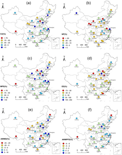
Figure 5. Comparative analysis of urban lake landscape metrics between 1990 and 2015.
Although MPS of the whole region increased between 1990 and 2015, regional differences among the three subregions were remarkable. Over the 25 years, MPS of urban lakes in eastern and western regions increased by 23.37% and 2.55%, respectively, whereas the central region experienced a decrease of 16.65%. This suggests that urban lakes in the central cities are more fragmented. In terms of spatial distribution, Nanchang, Changsha, and Wuhan are the core areas in central China with a decreasing value of MPS, which implies that more attention should be paid to the strict management for landscape fragmentation of urban lakes.
Although the values of ED of all three regions showed an upward trend, the magnitude of changes was different. The central cities experienced the largest growth in the value of ED (15.66%), followed by the western region (9.31%) and eastern region (4.93%). The observed results revealed that the three regions all had a higher degree of fragmentation of urban lake landscape. Regional variation in the ED indicated that central region had the most significant fragmentation in urban lake landscape.
From the perspective of shape complexity, the whole region witnessed a decline in the value of AWMSI, which is indicative of more regular and simpler shape of urban lakes. Urban lakes in the central cities had a higher mean value of AWMSI than the other regions (), suggesting that the central areas had the most complex urban lake shapes. In terms of changes, the central region experienced the largest decrease (11.66%) in AWMSI, whereas a slight increase (3.74%) was observed in the eastern region. A different changing pattern was exhibited in the value of AWMPFD, showing a minor reduction in the central and western regions. Along with rapid progress in urbanization, intensive human alterations that reshaped the existing urban lakes may result in a reduction in complexity and irregularity of their shapes. Therefore, effective action is required to prevent further changes to the shorelines of urban lakes, especially in central China.
3.3. Spatial patterns of urban lake shrinkage
To better understand the spatial patterns of urban lake shrinkage, the relative fractions or composition of the three lake-shrinkage types (i.e. vanishment, edge-shrinkage, and tunneling) in terms of patch number or area are illustrated in . The fraction of vanishment and edge-shrinkage accounted for 42.99% and 49.65% in terms of patch number, respectively, while the number of tunneling has been the smallest (7.36%) among the three. In the central China, the relative fraction of edge-shrinkage was higher than other regions. For example, urban lakes in Wuhan and Nanchang suffered from the serious encroachment in the fringes, leading to the landscape patterns of lakes to be more regular. The results generally supported the shape of their urban lakes tended to be simpler, indicated by decreased AWMSI and AWMPFD. The urban lakes in eastern regions have disappeared seriously, inducing a large proportion of vanishment in patch number.
Figure 6. The proportional composition of the three shrinkage types (i.e. vanishment, edge-shrinkage, and tunneling) in terms of patch number (a) and patch area (b). The sum of the proportions equals to 100%; the circle represents the location of the intersection of the three means, shown by the dashed lines.
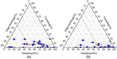
In terms of patch area, vanishment was the dominant lake-shrinkage form (63.33%), followed by edge-shrinkage (30.34%) and tunneling (6.33%). Especially in the eastern and western regions, the urban lakes experienced a severe loss in patch area, inducing the weight of vanishment occupied over 80% among the three shrinkage types. For instance, patch vanishment was the most intensive form of lake shrinkage in Guangzhou, Fuzhou, and Chengdu, where a high proportion of small-sized lake patch was completely encroached over the 25 years.
3.4. Driving forces behind landscape change patterns of urban lakes
Under the accelerated process of urbanization, urban lakes have undergone profound land-use changes due to intensive human activities, which converted lake water areas into built-up areas, cultivated land, or aquaculture ponds (Xie et al. Citation2017). The exploitation of lake resources provided essential ecosystem goods for human development, but at the expense of a rapid loss in lake areas. To explore the driving mechanisms behind landscape change patterns of urban lakes, we investigated the land-use/cover conversions of urban lakes between 1990 and 2015. The land-use changes from lakes to the six general classes and built-up land subclasses (Kuang et al. Citation2016), that is, grassland, woodland, cropland, water, unused land, and built-up areas (including urban land, industrial land, and rural settlement), are illustrated in . The results revealed that the significant reduction of lake areas was mainly driven by urban expansion, that is, lakes were directly converted into urban and industrial land, accounting for 47.05% (11,765.58 ha) and 20.84% (5212.26 ha) of the total area loss, respectively. Furthermore, the transition from lakes into agricultural land can also explain a large proportion of decline in surface area (i.e. 4967.18 ha, 19.86%), as a result of extensive lake reclamation for cultivated areas. Spatially, the urban lakes in the central region suffered from the most severe loss in surface area (16,863.07 ha), which was primarily converted into the urban land (44.52%), industrial land (25.51%), and agricultural land (22.29%). The eastern and western regions showed a similar pattern of lake conversions, that is, the lake surface areas were mainly replaced by urban built-up areas, resulting in the area decline of 61.60% and 71.04%, respectively. The percentage distributions of land-use conversions of urban lakes in each subregion () also revealed that the transformation from lakes into developed land accounted for the highest proportion (62.38% on average). Overall, rapid urban sprawl was the leading driving force of severe loss in urban lakes, inducing the land-use transitions from lakes into urban human settlements in the past few decades.
Figure 7. Boxplots show the percentage distributions of land use (including urban land, industrial land, rural settlement, grassland, woodland, cropland, water, and unused land) in area, to which urban lakes were converted between 1990 and 2015 in (a) eastern region, (b) central region, (c) western region, and (d) whole region. The horizontal lines (boxes and whiskers) in each boxplot are the 10th, 25th, 50th, 75th, and 90th percentiles, and the circles indicate the fifth and 95th percentiles.
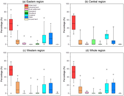
Table 3. Land-use changes of urban lakes between 1990 and 2015.
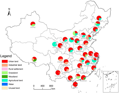
The land-use changes of urban lakes among the 32 cities exhibited different spatial patterns, depending on the regional lake environment and economic conditions (). Along with rapid urban expansion over the past several decades, Wuhan, Nanchang, and Changsha, with abundant freshwater lake resources in central China, have experienced the most drastic shrinkage in lake areas (a total loss of 10,436.28 ha, 3223.98 ha, and 1661.77 ha, respectively), which were dominated by the transitions to built-up areas, accounting for 72.58%, 60.09%, and 86.98%, respectively. In the eastern region, Beijing and Nanjing also witnessed a large degradation from lakes to built-up areas, occupying 45.98% (803.97 ha) and 92.75% (1006.34 ha) of the total loss in lake areas, respectively. Yinchuan City is a typical oasis area with the most characteristic and significant wetland resources in the semi-arid/arid region of northwest China, which has experienced a decrease of 303.55 ha (62.39%) in lake surface areas between 1990 and 2015, devoted to urban human settlements.
Figure 8. The proportional composition of land-use types, to which urban lakes were converted in China’s 32 major cities between 1990 and 2015.
4. Discussion
Since the economic reform of China in 1978, especially after its land reform in 1987, rapid population growth and urban expansion have given rise to a considerable and sustained demand for urban construction, industrial development and housing (Li et al. Citation2006). The unprecedented urbanization has posed significant impacts on the landscape patterns of urban lakes due to intensive anthropogenic activities, for example, construction, burial, drainage, and reshaping (Steele and Heffernan Citation2014). In the cities, small and shallow water bodies are more likely to be drained and replaced by built-up areas, which has a notable effect on the abundance and distribution of urban lakes. For example, the preferential drainage or removal of small-size urban lakes has led to a large decline in the number of patch in the eastern region, for example, Beijing (74.29%), Nanjing (56.22%), and Guangzhou (41.89%). However, the cases in central China (e.g. Wuhan, Nanchang, and Changsha) have showed that nearly all the urban water bodies, either large or small lakes, have been suffering from significant alterations during urbanization (Du, Ottens, and Sliuzas Citation2010), resulting in the decreases of NP (9.17%, 8.70%, and 33.78%, respectively) and MPS (15.22%, 24.06%, and 14.70%, respectively). The construction of man-made lakes in the urban areas may also affect the landscape patterns of urban lakes. For instance, the total surface area of urban lakes in Shanghai has increased by 98.91 ha (125.31% in proportion) between 1990 and 2015, with an increase of 45.45% in the number of patches. In addition, the physical reshaping (e.g. construction and impounding) of existing urban lakes contributes to the changes in spatial and geometrical characteristics of urban lakes. For example, the urban lakes in Wuhan witnessed a large reduction in AWMSI (a decrease of 22.99%) between 1990 and 2015, suggesting that the shape complexity tends to be more regular and simpler. Along with rapid urbanization and economic development, the construction of large-scale infrastructure projects (e.g. main roads, outer ring highways, and subways) has resulted in increased fragmentation and reduced connectivity of urban lakes. For instance, the central cities (e.g. Wuhan, Changsha, and Nanchang) experienced a decline in MPS (15.22%, 14.70%, and 24.06%, respectively) and a growth in ED (4.35%, 15.19%, and 1.69%, respectively) between 1990 and 2015, indicating that the three cities all had a higher degree of fragmentation of urban lake landscape. Therefore, more efforts on lake management should be made to restrain the tendency toward a more fragmentary landscape of urban lakes, especially in the central cities.
Rapid urbanization and industrialization have also posed significant threats to the land-use structure in the watershed regions of urban lakes (Liu et al. Citation2007). For example, accelerated urban sprawl has resulted in intensive land-use alterations in the watershed areas of Nan Lake and Dong Lake in Wuhan (), where built-up areas increased by 106.71% and 59.68%, respectively. The excessive urban sprawl resulted in a significant loss in relatively wild habitats, such as lake water areas and urban forests. In comparison, little changes can be found in the water areas of Xuanwu Lake in Nanjing and West Lake in Hangzhou, thanks to the local government’s conservation and management in urban scenic spots. However, the two lakes have also witnessed the major land-use transitions from cropland to urban areas, resulting in a significant reduction (86.49% and 30.40%, respectively) of cultivated areas between 1990 and 2015. The process of urbanization is associated with a rapid increase in impervious surface area, which has significant impacts on urban hydrologic cycle (Niemczynowicz Citation1999). Increased proportion of impervious surface can lead to a reduction in the capacity for the urban landscape to infiltrate precipitation, higher runoff peaks, and total volume of runoff, which increased the risk of water-logging and more frequent flooding in the cities (Shuster et al. Citation2005). In a developed watershed, the impervious surface may significantly affect the natural groundwater recharge and the connection between lakes and river systems, resulting in decreased water supply to lakes and the shrinkage of lake areas (Du, Ottens, and Sliuzas Citation2010).
Figure 9. Watershed areas of typical urban lakes: (a) Nan Lake, (b) Dong Lake, (c) West Lake, and (d) Xuanwu Lake.
In spite of land-use changes, the human-induced rapid loss in lake areas has exerted significant impacts on the hydrological and ecological services (Fang, Rao, and Zhao Citation2005; Xie et al. Citation2017), for example, increasing flood disasters, decreasing biodiversity, and water pollution. The rapid shrinkage of urban lakes and their reduced connection with the river systems has greatly reduced the water storage and drainage capacity, which increased the risk of flooding and water-logging in the cities (Zong and Chen Citation2000; Wu Citation2002). Moreover, severe degradation of urban lakes has also resulted in rapid loss of habitats, inducing a decline of biodiversity. For example, the species richness of fishes in Dong Lake (Wuhan) has decreased rapidly during the past few decades, consistent with the loss of lake area. The species richness of aquatic vascular plants in Dong Lake decreased from 50 in the late 1980s to 33 in the early 2000s (Yao, Li, and Xia Citation1990; Wu et al. Citation2003).
In addition, rapid urbanization and industrialization have led to intensified land-use changes in the urban lakes and the surrounding watershed areas, which increased the rate of urban contaminant inputs (such as nitrogen and phosphorus) to the lakes, inducing the severe deterioration of water quality (Cheng and Li Citation2006; Diamond and Hodge Citation2007; Zhiying et al. Citation2008; Mei et al. Citation2010; Chao et al. Citation2003; Wang et al. Citation2016; Xiao et al. Citation2016). For instance, Dong Lake in Wuhan has experienced rapid loss of lake area and severe degradation of water quality. The total nitrogen (TN) and chemical oxygen demand (CODMn) in Dong Lake increased from 1.92 and 4.7 mg/L in 1986 to 2.46 and 7.6 mg/L in 2000, respectively (Cheng and Li Citation2006). In the lake watersheds, the human-induced transitions from agricultural land to urban areas may lead to even greater levels of water pollution. For example, with the increase of developed areas in the watershed of Tangxun Lake, the high-value areas of pollutant loads expanded from north to south. The TN and total phosphorus (TP) loads in Tangxun Lake showed an increasing tendency since 1991, and by 2020 the TN and TP loads will increase to 370.06 and 33.89 t/year, respectively (Yanhua et al. Citation2013). Urban water pollution has significant effects on the function of the lake as a drinking water supply and the landscape value of the surrounding areas in the cities.
To mitigate these negative impacts, local governments have implemented a series of policies, such as lake conservation and restoration projects (Du, Ottens, and Sliuzas Citation2010; Zhang et al. Citation2008; Zhiying et al. Citation2008), which have played an important role in the land-use control and environmental regulation in the watersheds of urban lakes. However, under the accelerated urban expansion and economic development, the lake resources within the urban regions are still suffering from the intensive land-use alterations induced by human activities, leading to serious consequences on the landscape characteristics of urban lakes. Therefore, there is a pressing need to make current ecological knowledge about the landscape change patterns of urban lakes, which can help inform future decision-making for urban landscape design and lake management (Birch and McCaskie Citation1999).
5. Conclusion
This study aimed to advance the understanding of spatiotemporal change patterns of urban lake landscape and the associated driving forces in China’s 32 major cities between 1990 and 2015. The results demonstrated that the total surface area of urban lakes decreased by 17,620.02 ha (24.22% in proportion) over the 25 years, with a significant increase in fragmentation and a reduction in tortuosity and irregularity of the shorelines. The spatial analysis of lake-shrinkage patterns was performed in this study, which revealed that vanishment was the dominant lake-shrinkage form (63.33%), followed by edge-shrinkage (30.34%) and tunneling (6.33%) in terms of patch area. Moreover, we investigated the land-use changes of urban lakes between 1990 and 2015 and found that rapid urban sprawl was the leading driving force of the lake changes, accounting for 67.89% of the total area loss, and the conversion from lakes to agricultural land was also an important factor (19.86%). With its unprecedented urban expansion and population growth, coordinating the conflict between lake protection and land demands for human settlement in the cities will continue to be a primary challenge for China in the future. Our results can provide a scientific foundation for decision-making for urban landscape designs and lake resources conservation.
Acknowledgements
The authors wish to thank the anonymous reviewers who did a thorough critical review of the manuscript and provided valuable suggestions to improve it.
Disclosure statement
No potential conflict of interest was reported by the authors.
Additional information
Funding
References
- Birch, Stephen, and Janice McCaskie. 1999. “Shallow Urban Lakes: A Challenge for Lake Management.” Hydrobiologia 395/396 (0): 365–378. doi:10.1023/A:1017099030774.
- Cael, B. B., and D. A. Seekell. 2016. “The Size-distribution of Earth’s Lakes.” Scientific Reports 6: 2388. doi: 10.1038/srep29633
- Carroll, Mark, and Tatiana Loboda. 2017. “Multi-decadal Surface Water Dynamics in North American Tundra.” Remote Sensing 9 (5): 497. doi:10.3390/rs9050497.
- Carroll, M. L., J. R. Townshend, C. M. DiMiceli, P. Noojipady, and R. A. Sohlberg. 2009. “A New Global Raster Water Mask at 250 m Resolution .” International Journal of Digital Earth 2 (4): 291–308. doi:10.1080/17538940902951401.
- Chao, Gao, Ji Ye Zhu, Ke Wei Dai, Gao Song, and Yi Jian Dou. 2003. “Impact of Rapid Urbanization on Water Quality and Related Mitigation Options in Taihu Lake Area.” Scientia Geographica Sinica 23 (6): 746–750.
- Chen, Jie. 2007. “Rapid Urbanization in China: A Real Challenge to Soil Protection and Food Security.” CATENA 69 (1): 1–15. doi:10.1016/j.catena.2006.04.019.
- Chen, Jianglong, Jinlong Gao, and Feng Yuan. 2016. “Growth Type and Functional Trajectories: An Empirical Study of Urban Expansion in Nanjing, China.” Plos One 11 (2): e0148389. doi:10.1371/journal.pone.0148389.
- Cheng, Xiao Ying, and Shi Jie Li. 2006. “An Analysis on the Evolvement Processes of Lake Eutrophication and Their Characteristics of the Typical Lakes in the Middle and Lower Reaches of Yangtze River.” Chinese Science Bulletin 51 (13): 1603–1613. doi:10.1007/s11434-006-2005-4.
- Diamond, Miriam L., and Erin Hodge. 2007. “Urban Contaminant Dynamics: From Source to Effect.” Environmental Science & Technology 41 (11): 3796–3800. doi:10.1021/es072542n.
- Du, Ningrui, Henk Ottens, and Richard Sliuzas. 2010. “Spatial Impact of Urban Expansion on Surface Water Bodies – A Case Study of Wuhan, China.” Landscape and Urban Planning 94 (3–4): 175–185. doi: 10.1016/j.landurbplan.2009.10.002
- Du, Hongyu, Xuejun Song, Hong Jiang, Zenghui Kan, Zhibao Wang, and Yongli Cai. 2016. “Research on the Cooling Island Effects of Water Body: A Case Study of Shanghai, China.” Ecological Indicators 67: 31–38. doi:10.1016/j.ecolind.2016.02.040.
- Fang, Chuanglin, Guangdong Li, and Shaojian Wang. 2016. “Changing and Differentiated Urban Landscape in China: Spatiotemporal Patterns and Driving Forces.” Environmental Science & Technology 50 (5): 2217–2227. doi:10.1021/acs.est.5b05198.
- Fang, Jingyun, Sheng Rao, and Shuqing Zhao. 2005. “Human-induced Long-term Changes in the Lakes of the Jianghan Plain, Central Yangtze.” Frontiers in Ecology and the Environment 3 (4): 186–192. doi:10.1890/1540-9295(2005)003[0186:HLCITL]2.0.CO;2.
- Feng, Min, Joseph O. Sexton, Saurabh Channan, and John R. Townshend. 2016. “A Global, High-resolution (30-m) Inland Water Body Dataset for 2000: First Results of a Topographic-spectral Classification Algorithm.” International Journal of Digital Earth 9 (2): 113–133. doi:10.1080/17538947.2015.1026420.
- Gao, H., T. J. Bohn, E. Podest, K. C. Mcdonald, and D. P. Lettenmaier. 2011. “On the Causes of the Shrinking of Lake Chad.” Environmental Research Letters 6 (3): 329–346. doi: 10.1088/1748-9326/6/3/034021
- Hamer, Andrew J., and Kirsten M. Parris. 2011. “Local and Landscape Determinants of Amphibian Communities in Urban Ponds.” Ecological Applications 21 (2): 378–390. doi:10.1890/10-0390.1.
- Kaza, Nikhil. 2013. “The Changing Urban Landscape of the Continental United States.” Landscape and Urban Planning 110: 74–86. doi:10.1016/j.landurbplan.2012.10.015.
- Kuang, Wenhui, Jiyuan Liu, Jinwei Dong, Wenfeng Chi, and Chi Zhang. 2016. “The Rapid and Massive Urban and Industrial Land Expansions in China between 1990 and 2010: A CLUD-based Analysis of Their Trajectories, Patterns, and Drivers.” Landscape and Urban Planning 145: 21–33. doi:10.1016/j.landurbplan.2015.10.001.
- Li, Junsheng, Shenglei Wang, Yanhong Wu, Bing Zhang, Xiaoling Chen, Fangfang Zhang, Qian Shen, Dailiang Peng, and Liqiao Tian. 2016. “MODIS Observations of Water Color of the Largest 10 Lakes in China between 2000 and 2012.” International Journal of Digital Earth 9 (8): 788–805. doi:10.1080/17538947.2016.1139637.
- Li, Yan, Shuqing Zhao, Kun Zhao, Ping Xie, and Jingyun Fang. 2006. “Land-cover Changes in an Urban Lake Watershed in a Mega-City, Central China.” Environmental Monitoring and Assessment 115 (1): 349–359. doi:10.1007/s10661-006-6559-z.
- Liao, Jingjuan, Guozhuang Shen, and Yingkui Li. 2013. “Lake Variations in Response to Climate Change in the Tibetan Plateau in the Past 40 Years.” International Journal of Digital Earth 6 (6): 534–549. doi:10.1080/17538947.2012.656290.
- Lin, George C. S. 2002. “The Growth and Structural Change of Chinese Cities: A Contextual and Geographic Analysis.” Cities (London, England) 19 (5): 299–316. doi:10.1016/S0264-2751(02)00039-2.
- Liu, Jiyuan, Wenhui Kuang, Zengxiang Zhang, Xinliang Xu, Yuanwei Qin, Jia Ning, Wancun Zhou, et al. 2014. “Spatiotemporal Characteristics, Patterns, and Causes of Land-use Changes in China since the Late 1980s.” Journal of Geographical Sciences 24 (2): 195–210. doi:10.1007/s11442-014-1082-6.
- Liu, Wenchao, Jiyuan Liu, Wenhui Kuang, and Jia Ning. 2017. “Examining the Influence of the Implementation of Major Function-oriented Zones on Built-up Area Expansion in China.” Journal of Geographical Sciences 27 (6): 643–660. doi:10.1007/s11442-017-1398-0.
- Liu, Jiyuan, Mingliang Liu, Hanqin Tian, Dafang Zhuang, Zengxiang Zhang, Wen Zhang, Xianming Tang, and Xiangzheng Deng. 2005. “Spatial and Temporal Patterns of China’s Cropland During 1990–2000: An Analysis Based on Landsat TM Data.” Remote Sensing of Environment 98 (4): 442–456. doi:10.1016/j.rse.2005.08.012.
- Liu, Yong, Xiaojian Lv, Xiaosheng Qin, Huaicheng Guo, Yajuan Yu, Jinfeng Wang, and Guozhu Mao. 2007. “An Integrated GIS-based Analysis System for Land-use Management of Lake Areas in Urban Fringe.” Landscape and Urban Planning 82 (4): 233–246. doi:10.1016/j.landurbplan.2007.02.012.
- Liu, Hongyan, Yi Yin, Shilong Piao, Fengjun Zhao, Mike Engels, and Philippe Ciais. 2013. “Disappearing Lakes in Semiarid Northern China: Drivers and Environmental Impact.” Environmental Science & Technology 47 (21): 12107–12114. doi:10.1021/es305298q.
- Ma, Ronghua, Hongtao Duan, Chuanmin Hu, Xuezhi Feng, Ainong Li, Weimin Ju, Jiahu Jiang, and Guishan Yang. 2010. “A Half-century of Changes in China’s Lakes: Global Warming or Human Influence?” Geophysical Research Letters 37 (24): L24106. doi: 10.1029/2010GL045514
- Mei, Xuefei, Zhijun Dai, Jinzhou Du, and Jiyu Chen. 2015. “Linkage between Three Gorges Dam Impacts and the Dramatic Recessions in China’s Largest Freshwater Lake, Poyang Lake.” Scientific Reports 5: 18197. doi: 10.1038/srep18197
- Mei, Zhuohua, Zhehai Zhang, Chunxia Zhao, X. U. Min, and L. I. Min. 2010. “Dynamics of Phytoplankton and Water Quality with Control of Cyanobacterial Bloom in Lake Xuanwu, Nanjing [J].” Journal of Lake Sciences 1: 008.
- Naselli-Flores, L. 2008. “Urban Lakes: Ecosystems at Risk, Worthy of the Best Care.” In Proceedings of Taal2007: The 12th World Lake Conference, 1333–1337.
- Niemczynowicz, Janusz. 1999. “Urban Hydrology and Water Management – Present and Future Challenges.” Urban Water 1 (1): 1–14. doi:10.1016/S1462-0758(99)00009-6.
- Novotny, Eric V., Dan Murphy, and Heinz G. Stefan. 2008. “Increase of Urban Lake Salinity by Road Deicing Salt.” Science of the Total Environment 406 (1–2): 131–144. doi:10.1016/j.scitotenv.2008.07.037.
- Ren, Wenwei, Yang Zhong, John Meligrana, Bruce Anderson, W. Edgar Watt, Jiakuan Chen, and Hok-Lin Leung. 2003. “Urbanization, Land use, and Water Quality in Shanghai.” Environment International 29 (5): 649–659. doi:10.1016/S0160-4120(03)00051-5.
- Seto, Karen C., and Michail Fragkias. 2005. “Quantifying Spatiotemporal Patterns of Urban Land-use Change in Four Cities of China with Time Series Landscape Metrics.” Landscape Ecology 20 (7): 871–888. doi:10.1007/s10980-005-5238-8.
- Shuster, W. D., J. Bonta, H. Thurston, E. Warnemuende, and D. R. Smith. 2005. “Impacts of Impervious Surface on Watershed Hydrology: A Review.” Urban Water Journal 2 (4): 263–275. doi:10.1080/15730620500386529.
- Smith, L. C., Y. Sheng, G. M. Macdonald, and L. D. Hinzman. 2005. “Disappearing Arctic Lakes.” Science 308 (5727): 1429. doi:10.1126/science.1108142.
- Steele, M. K., and J. B. Heffernan. 2014. “Morphological Characteristics of Urban Water Bodies: Mechanisms of Change and Implications for Ecosystem Function.” Ecological Applications 24 (5): 1070–1084. doi:10.1890/13-0983.1.
- Steeneveld, G. J., S. Koopmans, B. G. Heusinkveld, and N. E. Theeuwes. 2014. “Refreshing the Role of Open Water Surfaces on Mitigating the maximum Urban Heat Island Effect.” Landscape and Urban Planning 121: 92–96. doi:10.1016/j.landurbplan.2013.09.001.
- Sun, Ranhao, and Liding Chen. 2012. “How Can Urban Water Bodies Be Designed for Climate Adaptation?.” Landscape and Urban Planning 105 (1–2): 27–33. doi:10.1016/j.landurbplan.2011.11.018.
- Sun, Ranhao, Ailian Chen, Liding Chen, and Yihe Lü. 2012. “Cooling Effects of Wetlands in an Urban Region: The Case of Beijing.” Ecological Indicators 20: 57–64. doi:10.1016/j.ecolind.2012.02.006.
- Sun, Fangdi, Yuanyuan Zhao, Peng Gong, Ronghua Ma, and Yongjiu Dai. 2014. “Monitoring Dynamic Changes of Global Land Cover Types: Fluctuations of major Lakes in China Every 8 Days During 2000–2010.” Chinese Science Bulletin 59 (02): 171–189. doi:10.1007/s11434-013-0045-0.
- Tranvik, Lars J., John A. Downing, James B. Cotner, Steven A. Loiselle, Robert G. Striegl, Thomas J. Ballatore, Peter Dillon, et al. 2009. “Lakes and Reservoirs as Regulators of Carbon Cycling and Climate.” Limnology and Oceanography 54: 2298–2314. doi:10.4319/lo.2009.54.6_part_2.2298.
- Tyler, Marnie W., and David L. Peterson. 2004. “Effects of Forest Policy on Landscape Pattern of Late-Seral Forest of the Western Olympic Peninsula, Washington.” Agriculture, Ecosystems & Environment 101 (2–3): 289–306. doi:10.1016/j.agee.2003.09.020.
- United Nations. 2014. World Urbanization Prospects: the 2014 Revision. Department of Economic and Social Affairs. New York: Population Division.
- Wang, Siyang, Hui Li, Jian Xiao, Yiyong Zhou, Chunlei Song, Yonghong Bi, and Xiuyun Cao. 2016. “Enhancement of Sediment Phosphorus Release During a Tunnel Construction Across an Urban Lake (Lake Donghu, China).” Environmental Science and Pollution Research 23 (17): 17774–17783. doi:10.1007/s11356-016-6949-x.
- Wu, Q. Z. 2002. “The Urban Flood Control and Mitigation in the 21st Century.” Urban Plann Rev 137: 68–70.
- Wu, Z. B., D. Q. Chen, D. R. Qiu, and B. Y. Liu. 2003. “Investigation of the Distribution of the Aquatic Vegetation in Lake Donghu, Wuhan.” Chongqing Environ Sci 25: 54–62.
- Xiao, Rui, Guofeng Wang, Qianwen Zhang, and Zhonghao Zhang. 2016. “Multi-scale Analysis of Relationship between Landscape Pattern and Urban River Water Quality in Different Seasons.” Scientific Reports 6: 36.
- Xie, Cong, Xin Huang, Hongqiang Mu, and Wei Yin. 2017. “Impacts of Land-Use Changes on the Lakes Across the Yangtze Floodplain in China.” Environmental Science & Technology. doi:10.1021/acs.est.6b04260.
- Xu, Chi, Maosong Liu, Cheng Zhang, Shuqing An, Wen Yu, and Jing M. Chen. 2007. “The Spatiotemporal Dynamics of Rapid Urban Growth in the Nanjing Metropolitan Region of China.” Landscape Ecology 22 (6): 925–937. doi:10.1007/s10980-007-9079-5.
- Yang, Xiankun, and Xixi Lu. 2015. “Drastic Change in China’s Lakes and Reservoirs Over the Past Decades.” Scientific Reports 4: 243. http://www.nature.com/articles/srep06041#supplementary-information.
- Yanhua, Zhuang, Hong Song, Zhang Wenting, Lin Hongyan, Zeng Qinghui, Nguyen Thuminh, Niu Beibei, and Li Wanyi. 2013. “Simulation of the Spatial and Temporal Changes of complex Non-point Source Loads in a Lake Watershed of Central China.” Water Science and Technology 67 (9): 2050–2058. doi:10.2166/wst.2013.083.
- Yao, Z. W., Y. J. Li, and S. L. Xia. 1990. “Studies of the Aquatic Vascular Plants and Eutrophication in Wuhan East Lake.” Chongqing Environ Sci 12: 26–30.
- Zeng, Feng, Jiaxin Wen, Kunyan Cui, Lina Wu, Min Liu, Yangjie Li, Yujun Lin, Fang Zhu, Zhiling Ma, and Zunxiang Zeng. 2009. “Seasonal Distribution of Phthalate Esters in Surface Water of the Urban Lakes in the Subtropical City, Guangzhou, China.” Journal of Hazardous Materials 169 (1–3): 719–725. doi:10.1016/j.jhazmat.2009.04.006.
- Zhang, Fengling, Jingling Liu, Zhifeng Yang, and Yongli Li. 2008. “Ecosystem Health Assessment of Urban Rivers and Lakes – Case Study of ‘the Six Lakes’ in Beijing, China.” Frontiers of Environmental Science & Engineering 2 (2): 209–217. doi: 10.1007/s11783-008-0007-y
- Zhiying, W. U., Y. U. Zuoming, S. H. E. N. G. Haiyan, X. U. Jun, H. A. N. Yicai, X. U. Yuntai, F. E. N. G. Ning, and Y. A. O. Jiamei. 2008. “Ecological Effects of the Dredging in the West Lake, Hangzhou [J].” Journal of Lake Sciences 3: 005.
- Zhuang, Dafang, Jiyuan Liu, and Mingliang Liu. 1999. “Research Activities on Land-use/Cover Change in the Past Ten Years in China Using Space Technology.” Chinese Geographical Science 9 (4): 330–334. doi:10.1007/s11769-999-0006-3.
- Zong, Yongqiang, and Xiqing Chen. 2000. “The 1998 Flood on the Yangtze, China.” Natural Hazards 22 (2): 165–184. doi:10.1023/A:1008119805106.