
Since virtual geographic environments (VGEs) were unofficially proposed for the first time at a conference in 1998, nearly two decades have passed. During these years, VGE has experienced several stages of evolution (Chen, Lin, and Lu Citation2017), and its definition has been modified over the course of its evolution (see Lin and Gong Citation2001; Lin and Zhu Citation2005; Gong, Zhou, and Zhang Citation2010; Lu Citation2011; Lin, Chen, and Lu Citation2013; Lin et al. Citation2013; Chen et al. Citation2017). Currently, the term VGE can be described as a kind of digital geographic environment generated by computers and related technologies that users can use to experience and recognize complex geographic systems and further conduct comprehensive geographic analyses, through equipped functions, including multi-channel human–computer interactions (HCIs), distributed geographic modelling and simulations, and network geo-collaborations. Generally, according to the categories of geographic processes and phenomena that are embraced in VGEs (Lin et al. Citation2015), there are mainly three typical types of VGEs: similar and enhanced contemporary geographic environments, reproduced and recovered historical geographic environments, and predicted and planned future geographic environments.
This latest definition provides a clearer description of VGEs; in particular, it indicates that the main body of VGEs is geographic environments, not just virtual environments. Recently, there has been an appearance in the revival of VR, in addition, the rising of Augmented Reality (AR) and Mixed Reality (MR), will cause VGEs to make great developmental progress. In our opinion, the enhanced VR/AR/MR can obviously benefit users by providing virtual or virtual–real mixed environments for a more natural and realistic perception and experience; however, virtual environments can be essential digital geographic environments only after geographic laws, rules and knowledges are integrated. From the perspective of geographers, a geographic environment is not just a spatial space, it is more; geographic environments mainly refer to the surfaces on which human societies exist and develop, and they are composed of various kinds of syntheses (including both natural and social factors). To better reflect geographic environments, by accepting static spatial variations and patterns, dynamic evolutionary processes and mutual interactions are all key objects that need more attention. VR/AR/MR are mostly employed to build spaces (either virtual or mixed) with rich geometrical and physical attributions, but geographic processes, phenomena and interactive mechanisms at different scales can only be provided from geographic aspects. This is the very distinction between VGEs and other purely VR/AR/MR technology-based environments.
Therefore, understanding the integration of geography into environmental construction is the key to building VGEs. Following the appropriate architecture we proposed in 2013 (Lin, Chen, and Lu Citation2013a), the four sub-environments, i.e. data environments, modelling and simulation environments, expression environments (former interactive environments), and collaborative and interactive environments (former collaborative environments), should be designed together to fill the gaps. Detailed information can be acquired from previous studies (see Lin, Chen, and Lu Citation2013a, Citation2013b; Chen et al. Citation2017), and cases related to technology application on sub-environments can also be found (e.g. Chen et al. Citation2012, Citation2013; Mekni Citation2012; Xu et al. Citation2013; Zhang, Lin, and Min Citation2014, Citation2015; Liang, Gong, and Li Citation2015; Rybansky et al. Citation2015; Torrens Citation2015a, Citation2015b; Zhu et al. Citation2015; Yin et al. Citation2017). However, it is still worth emphasizing that:
Data environments are the basic foundation for the development of VGEs. Since our geographers believe that geographic information contains context richer than spatiotemporal information, traditional data organization objects and related methods should be reconsidered. In addition to spatiotemporal attributes (e.g. locations, shapes) and relationships(e.g. topological relationship), there is much more geographic content that can be regarded as geographic information that describes geographic environments, such as semantics, other attributes and relationships (e.g. chemical and biological), and evolutionary processes. All these elements should be considered as a whole as contributors to powerful data organization and subsequent methods for the construction of geographic environments. Based on spatial decomposition approaches with graph theory techniques, Mekni (Citation2017) argued that semantics should be added to create semantically enriched and geometrically accurate VGEs, which he called Informed VGE (IVGE). Lü et al. (Citation2017) argued that geographic scene maybe a suitable schema to organize rich geographic information to tell complete stories, including time, location, people, things, events, processes, and phenomena, and further to support geo-visualization, geo-modelling and simulation, and geo-collaboration. They also proposed the Geographic Scenario as a theory to explore geographical scenes, their construction methods and applications. The above research showed great innovation for both the organization of geographic data in VGEs and the improvement of traditional GIS data models.
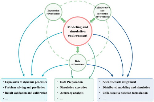
Modelling and simulation environments are core components that prepare VGEs for geographic analysis. Geographic analysis models are the abstraction and expression of geographic processes and phenomena; these models can also be regarded as another form of geographic knowledge and geographic laws. Geographic analysis models are an effective way to realize comprehensive geographic research and systematic understanding by treating various and interactive geographic processes as a whole. Thus, modelling complex geographic phenomena through model integration will benefit the construction of similar comprehensive geographic environments in VGEs, and simulations can be employed to inverse the past, predict the future, express these phenomena and reveal new rules. shows detailed functions that modelling and simulation environments can conduct cooperatively with other sub-environments in VGEs. Management of geographic analysis models in VGEs will also enable VGEs to be a tool for geographic knowledge engineering (Lin and Chen Citation2015; Zhang et al. Citation2016; You and Lin Citation2016). Moreover, it should be realized that currently, integrating human factors with natural factors for comprehensive geographic analysis is an irreversible trend. Although there are already numerous models existing that reflect natural phenomena (e.g. Larsen et al. Citation2016; Dugdale, Hannah, and Malcolm Citation2017), there is still a need to develop more human behaviour-integrated models at large, regional and local scales. Only both natural and human behaviour related models can be integrated into the model base for VGEs; VGEs can be equipped with simulation functions to explore human-involved geographic environments (Chen et al. Citation2015). From this perspective, Torrens (Citation2017) provided a modelling scheme to support simulations and experiments for the evacuation of people within critical damage scenarios based on automata. It is meaningful for the exploration of human dynamics in the real world and future model development in this field.
Figure 1. Detailed functions that modelling and simulation environments cooperatively with other sub-environments in VGEs.
The expression environment in VGEs is a systematic environment that is employed to express geographic elements, interactions and evolutionary processes through various visible and inductive channels. Based on our understanding, this environment can mainly provide visual expression channels (i.e. for visualization) and sensible expression channels (i.e. for touching, smelling and hearing). VR/AR/MR can play an important role in the construction of expression environments, and currently, many VGE systems primarily develop 3D-based visualization technologies to express dynamic geographic phenomena; for example, Rink et al. (Citation2017) visualized simulation results in a region around Chao Lake to contribute to water pollution control. With the booming VR/AR/MR, more vivid VGEs are expected to develop in the near future with mirrored geographic processes and phenomena and not just game-like environments. Moreover, the expression content should be extended due to the richness of the geographic information. The expression environment should support the expression of all non-matter sensible elements (e.g. light, temperature and smell) and non-sensible factors (e.g. the magnetic field) as they exist in the geographic environment when users have specific requirements. Here, support does not mean that all elements need to be expressed every time. There was an interesting topic proposed by Voinov et al. (Citation2017) that explored how to marry VGEs with simulations in a mutually beneficial way. The key word is properly, “making sure that VR indeed helps convey the message rather than distract stakeholders from the science, and analyses that come out of the modeling exercises”. This kind of discussion incurs a more in-depth way of thinking on the development of expression environments in VGEs.
Collaborative and interactive environments are designed to support collaborations and interactions among humans, geographic environments and machines, and their inner collaborations and interactions when using VGEs. It is also characteristic for VGEs to differ from traditional geographical cognition and GIS analysis tools that provide important means for users to conduct collaborative experiments and exploration. Here, humans, geographic environments and machines refer to those that exist both in the real environment and the virtual environment. Collaboration among humans includes human cooperative works and idea exchanges in the real environment, avatar-based human interactions and communications in the virtual environment, and manipulation and feedback between humans in the real environment and the avatar in the virtual environment. Collaboration among geographic environments includes influences and interactions among geographic elements in the real environment and corresponding inter-influences and co-evolutionary processes of virtual geographic elements in the virtual environment. Collaboration among machines mainly refers to the joint operation among different tasks in different machines and corresponding reflections in virtual systems. Apart from these kinds of collaborations, interactions among humans, geographic environments and machines are important to mix virtual and real environments for collaborative research. Here, we categorize the interaction between humans and machines in the collaborative and interactive environments; we think this is also a kind of collaboration, and that is why former interactive environments are modified into expression environments that focus on initial expressions, and collaborative environments are modified into collaborative and interactive environments that focus on multi-angle interactions. Only collaborations and interactions among humans, geographic environments and machines can be realized; a geographic analysis based on VGEs can break constraints on time and space and provide common users, researchers and decision-makers with an open workspace and opportunities for distributed collaborative problem solving and exploration. Regarding this issue, Oprean, Simpson, and Klippel (Citation2017) studied remote user experiences during collaboration and teamwork with the hope of better understanding geographically remote spaces. This work will be worth studying to explore the capacity enhancement of VGEs to support collaborative research.
In summary, geography should guide geographic information technologies and the development of related systems, including VGEs. The process of constructing virtual geographic environments that are mirrored by real geographic environments is an essential task for modelling, interpreting and exploring Earth's system to further contribute to the improvement of real environments. VR/AR/MR are important technologies for the development of VGEs, but the crucial core should still be geography. Although integrated VGEs with fully proposed functions are still under construction, this is still the time to emphasize geographic and analysis-centred VGEs over expression-centred VGEs.
Acknowledgements
The guest editors would like to thank the contributing authors. Many thanks also to the reviewers for their comments to improve the quality of the articles presented here.
Additional information
Funding
References
- Chen, M., H. Lin, O. Kolditz, and C. Chen. 2015. “Developing Dynamic Virtual Geographic Environments (VGEs) for Geographic Research.” Environmental Earth Sciences 74: 6975–6980. doi: 10.1007/s12665-015-4761-4
- Chen, M., H. Lin, and G. Lu, 2017. “Virtual Geographic Environments.” In The International Encyclopedia of Geography. Wiley and the American Association of Geographers (AAG). doi:10.1002/9781118786352.wbieg0448.
- Chen, M., H. Lin, Y. N. Wen, L. He, and M. Y. Hu. 2012. “Sino-VirtualMoon: A 3D Web Platform Using Chang’E-1 Data for Collaborative Research.” Planetary and Space Science 65 (1): 130–136. doi: 10.1016/j.pss.2012.01.005
- Chen, M., H. Lin, Y. N. Wen, L. He, and M. Y. Hu. 2013. “Construction of a Virtual Lunar Environment Platform.” International Journal of Digital Earth 6 (5): 469–482. doi: 10.1080/17538947.2011.628415
- Dugdale, S. J., D. M. Hannah, and I. A. Malcolm. 2017. “River temperature modelling: A review of process-based approaches and future directions.” Earth-Science Reviews 175: 97–113. doi: 10.1016/j.earscirev.2017.10.009
- Gong, J. H., J. P. Zhou, and L. H. Zhang. 2010. “Study Progress and theoretical Framework of Virtual Geographic Environments.” Advances in Earth Science 25 (9): 915–926.
- Larsen, L. G., M. B. Eppinga, P. Passalacqua, W. M. Getz, K. A. Rose, and M. Liang. 2016. “Appropriate complexity landscape modeling.” Earth-Science Reviews 160: 111–130. doi: 10.1016/j.earscirev.2016.06.016
- Liang, J. M., J. H. Gong, and Y. Li. 2015. “Realistic rendering for physically based shallow water simulation in Virtual Geographic Environments (VGEs).” Annals of GIS 21 (4): 301–312. doi: 10.1080/19475683.2015.1050064
- Lin, H., M. Batty, S. E. Jørgensen, B. J. Fu, M. Konecny, A. Voinov, P. Torrens et al. 2015. “Virtual Environments Begin to Embrace Process-Based Geographic Analysis.” Transactions in GIS 19 (4):493–498. doi: 10.1111/tgis.12167
- Lin, H., and M. Chen. 2015. “Managing and sharing geographic knowledge in virtual geographic environments (VGEs).” Annals of GIS 21 (4): 261–263. doi: 10.1080/19475683.2015.1099568
- Lin, H., M. Chen, and G. N. Lu. 2013. “Virtual Geographic Environment: A Workspace for Computer-Aided Geographic Experiments.” Annals of the Association of American Geographers 103 (3): 465–482. doi: 10.1080/00045608.2012.689234
- Lin, H., M. Chen, G. N. Lu, Q. Zhu, J. H. Gong, X. You, Y. N. Wen, B. L. Xu, and M. Y. Hu. 2013. “Virtual Geographic Environments (VGEs): A New Generation of Geographic Analysis Tool.” Earth-Science Reviews 126: 74–84. doi: 10.1016/j.earscirev.2013.08.001
- Lin, H., and J. H. Gong. 2001. “Exploring Virtual Geographic Environments.” Geographic Information Sciences 7 (1): 1–7.
- Lin, H., and Q. Zhu. 2005. “The Linguistic Characteristics of Virtual Geographic Environments.” Journal of Remote Sensing 9 (2): 158–165.
- Lu, G. N. 2011. “Geographic Analysis-oriented Virtual Geographic Environment: Framework, Structure and Functions.” Science China: Earth Science 54: 733–743. doi: 10.1007/s11430-011-4193-2
- Lü, G. N., M. Chen, L. W. Yuan, L. C. Zhou, Y. N. Wen, M. G. Wu, B. Hu, et al. 2017. “Geographic Scenario: A possible Foundation for Further Development of Virtual Geographic Environments.” International Journal of Digital Earth 20 (19), 1–13. doi:10.1080/17538947.2017.1374477.
- Mekni, M. 2012. “Abstraction of Informed Virtual Geographic Environments.” Geo-spatial Information Science 15 (2):27–36. doi: 10.1080/10095020.2012.708150
- Mekni, M. 2017. “Spatial Simulation Using Abstraction of Virtual Geographic Environments.” International Journal of Digital Earth 1 (1), 1–22. doi:10.1080/17538947.2017.1381190.
- Oprean, D., M., Simpson, A., and Klippel, 2017. “Collaborating Remotely: An Evaluation of Immersive Capabilities on Spatial Experiences and Team Membership.” International Journal of Digital Earth 1, 1–17. doi:10.1080/17538947.2017.1381191.
- Rink, K., C., Chen, L., Bilke, Z. L., Liao, K., Rinke, M., Frassl, T. X., Yue, and O. Kolditz, 2017. “Virtual Geographic Environments for Water Pollution Control.” International Journal of Digital Earth 5 (11), 1–11. doi:10.1080/17538947.2016.1265016.
- Rybansky, M., A. Hofmann, M. Hubacek, V. Kovarik, and V. Talhofer. 2015. “Modelling of Cross-country Transport in Raster Format.” Environmental Earth Sciences 74 (10): 7049–7058. doi: 10.1007/s12665-015-4759-y
- Torrens, P.M. 2015a. “Intertwining Agents and Environments.” Environmental Earth Sciences 74 (10):7117–7131. doi: 10.1007/s12665-015-4738-3
- Torrens, P. M. 2015b. “Slipstreaming Human Geosimulation in Virtual Geographic Environments.” Annals of GIS 21 (4): 325–344. doi: 10.1080/19475683.2015.1009489
- Torrens, P. M. 2017. “A Computational Sandbox with Human Automata for Exploring Perceived Egress Safety in Urban Damage Scenarios.” International Journal of Digital Earth 201 (1), 1–28. doi:10.1080/17538947.2017.1320594.
- Voinov, A., A. Çöltekin, M. Chen, and G. Beydoun. 2017. “Virtual Geographic Environments in Socio-Environmental Modeling: A Fancy Distraction or a Key to Communication?” International Journal of Digital Earth. doi:10.1080/17538947.2017.1365961.
- Xu, B. L., H. Lin, J. H. Gong, S. Tang, Y. Hu, I. A. Nasser, and T. Jing. 2013. “Integration of a Computational Grid and Virtual Geographic Environment to Facilitate Air Pollution Simulation.” Computers & Geosciences 54: 184–195. doi: 10.1016/j.cageo.2012.09.031
- Yin, L. Z., J. Zhu, Y. Li, C. Zeng, Q. Zhu, H. Qi, M. W. Liu, et al. 2017. “A Virtual Geographic Environment for Debris Flow Risk Analysis in Residential Areas.” ISPRS International Journal of Geo-Information 6 (12), 377. doi:10.3390/ijgi6110377.
- You, L., and H. Lin. 2016. “Towards a Research Agenda for Knowledge Engineering of Virtual Geographical Environments.” Annals of GIS 22 (3): 163–171.
- Zhang, C. X., M. Chen, Y. L. Ding, R. R. Li, and H. Lin. 2015. “A Virtual Geographic Environment System for Multiscale Air Quality Analysis and Decision Making: A Case Study of SO2 Concentration Simulation.” Applied Geography 63: 326–336. doi: 10.1016/j.apgeog.2015.07.011
- Zhang, C. X., M. Chen, R. R. Li, C. Y. Fang, and H. Lin. 2016. “What’s Going on about Geo-process Modeling in Virtual Geographic Environments (VGEs).” Ecological Modelling 319: 147–154. doi: 10.1016/j.ecolmodel.2015.04.023
- Zhang, C. X., H. Lin, and M. Min. 2014. “Scale Matching of Multiscale Digital Elevation Model (Dem) Data and the Weather Research and Forecasting (WRF) Model: A Case Study of Meteorological Simulation in Hong Kong.” Arabian Journal of Geosciences 7: 2215–2223. doi: 10.1007/s12517-014-1273-6
- Zhu, J., L. Z. Yin, J. H. Wang, H. Zhang, Y. Hu, and Z. J. Liu. 2015. “Dam-break Flood Routing Simulation and Scale Effect Analysis Based on Virtual Geographic Environment.” IEEE Journal of Selected Topics in Applied Earth Observations and Remote Sensing 8 (1): 105–113. doi: 10.1109/JSTARS.2014.2340399