
ABSTRACT
The Belt and Road initiative has a significant focus on infrastructure, trade, and economic development across a vast region, and it also provides significant opportunities for sustainable development. The combined pressure of climate variability, intensified use of resources, and the fragility of ecosystems make it very challenging, however, to achieve future sustainability. To develop the path in a sustainable way, it is important to have a comprehensive understanding of these issues across nations and evaluate them in a scientific and well-informed approach. In this context, the Digital Belt and Road (DBAR) program was initiated as an international venture to share expertise, knowledge, technologies, and data to demonstrate the role of Earth observation science and technology and big Earth data applications to support large-scale development. In this paper, we identify pressing challenges, present the research priorities and foci of the DBAR program, and propose solutions where big Earth data can make significant contributions. This paper calls for further joint actions and collaboration to build a digital silk road in support of sustainable development at national, regional and global levels.
1. Background
The historical land-based Silk Road from central China through central Asia to Europe was a major trading route, connecting China to the Mediterranean Sea. The maritime Silk Road revives a lesser known maritime trajectory of historical ocean voyages of Chinese vessels. In 2013, the Chinese government decided to launch the Belt and Road (B&R) initiative to promote economic cooperation (NDRC, 2015). As the B&R initiative has a significant focus on infrastructure, trade, and economic development across a vast region, it provides significant opportunities for experimenting with and demonstrating sustainable development pathways (Scott and Rajabifard Citation2017). Countries along the B&R are presented with a historical opportunity to work together to promote the international agenda to attain the United Nations (UN) Sustainable Development Goals (SDGs) by 2030 (UN Citation2015) and implement the Paris Agreement (UNFCCC Citation2015) to combat anthropologically induced climate change.
The combined pressure of environment and fragility of many ecosystems in the B&R countries, however, make the attainment of the UN SDGs an immensely challenging task. In addition, many environmental threats in the B&R countries, such as the management and use of water resources, the mitigation of air pollution, and the improvement of the quality of both inland and coastal waters, are inherently transnational and require close collaboration among countries to address and mitigate them.
Environmental and societal challenges will require assessment and monitoring of terrestrial and marine ecosystems, so that decisions and policies can be based on sound information. This in turn requires precise, accurate, and timely observations and measurements of processes across a range of spatial and temporal scales. These needs can be met with integrated networks for collecting data, such as Earth observation (EO) data.
At the same time, the level of EO infrastructure and capability, both human and technological, in the extraction of the required information from EO data is very different across B&R countries and poses a significant challenge for generating the timely and spatially relevant information required to stay on course towards sustainable development (Guo and Xiao Citation2016; Anderson et al. Citation2017). For example, ownership of existing EO infrastructure in the B&R region is heavily tilted in favor of Europe. Over half of the total 443 EO satellites launched along the B&R region since the 1960s have been from Europe and China have launched 87 satellites (Guo Citation2018).
In China, presently the spaceborne EO system consists of Earth resource satellites, meteorological satellites, ocean satellites, environmental and disaster mitigation satellites, high-resolution satellite systems, and the BeiDou navigation and positioning satellite. The China Remote Sensing Satellite Ground Station system has 70% of Asia-Pacific coverage of regional spatial data along the B&R. Some B&R countries are operating a growing fleet of EO satellites and there is overall a solid knowledge base, but so far, the investments in the development and generation of accurate data products have been limited. Also, merging raw data acquired by multiple satellites into a stream of multi-source data products in many ways leads countries into uncharted territory, both from a policy and a technological point of view.
However, the opportunity offered by the B&R initiative to bring data assets to full fruition for the common benefit of governments and people should not be missed. In recent years, macro-level research and dynamic analyses of ecological patterns and development potential for the B&R countries and regions along have provided fundamental macroscopic scientific data and decision-making support. Therefore, in order to meet this overarching challenge, it is vital to encourage and facilitate extensive pooling of human and technological resources among B&R countries.
In 2016, at the International Symposium on EO for One Belt and One Road, Chinese scientists in cooperation with experts from more than 22 countries and international organizations called upon the recognition of big data as the engine driving sound development. They proposed to establish coordinated efforts to ensure the sharing of advanced EO technologies and facilitate the exploitation of new scientific knowledge in order to address these challenges scientifically and enhance the chances for B&R countries to attain SDGs by 2030 (ISEO Citation2012; EMSR Citation2015; EOBAR Citation2016). The ‘Digital Belt and Road’ (DBAR) program, was launched for this purpose and could become a major contributor to China’s support to deliver SDGs, especially by measuring the indicators applied to monitor progress towards SDG targets (DBAR Citation2017).
2. General overview of the DBAR program
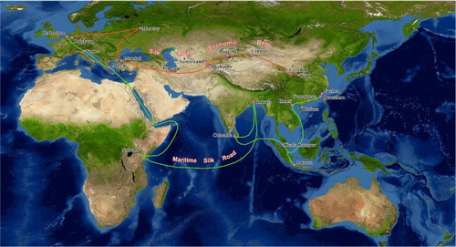
The DBAR program’s goal is to develop itself as a platform that will facilitate sharing of advanced EO technologies and information services across B&R countries for effective application of EO technology for sustainable economic and societal development ().
Figure 1. A sketch map of the Digital Belt and Road program overlaid with the two-major land and maritime silk roads.
The uniqueness of DBAR is its goal of building upon the diverse big Earth data capacities in the B&R countries in Asia, Europe, and Africa through a comprehensive and well-funded action. Its aim is to improve environmental monitoring, promote data sharing, and support policy-making using big data on EOs (DBAR Citation2017). DBAR will establish an international big Earth data analysis and decision-making system and carry out scientific analysis to better understand the spatial distribution of resources and ecosystems’ status and change trends in the B&R region.
2.1. Vision and mission
The DBAR vision is the promotion of international cooperation that integrates EO science, data, technology, and applications to address environmental change and attain SDGs in the B&R region. The DBAR mission is to mobilize EO scientific knowledge, technology, and data to enable B&R countries to sustainably develop their infrastructure, economy, environment, and to support decision-makers towards meeting the SDG goals and targets relevant to B&R countries (DBAR Citation2017).
These vision and mission statements call for the DBAR Science Plan to meet the following three objectives in its implementation: (1) to address knowledge gaps in Earth system processes that constrains the attainment of the SDGs in B&R countries; (2) to promote advanced science and decision support services to extract effective information from massive, diverse and ever-growing volumes of big Earth data; and (3) to enhance capacity building and technology transfer within a system of partnerships and research networks.
The DBAR program will also compile regional spatial assessment indicators to assess and monitor progress towards the UN SDGs.
2.2. DBAR Foci
The DBAR Foci are clusters of well-framed research questions relevant to UN SDGs and to B&R countries (). The DBAR has identified a set of scientific questions that relate to the research and development challenges across the B&R countries. These challenges are: the adaptation to climate and environment change, mitigation of disaster risk, water availability and security, agriculture and food security, protection of natural and cultural heritage, urban and infrastructure development, management of coastal and marine ecosystems, and sustainable development of high mountains and the Arctic.
Figure 2. DBAR Foci: from big Earth data to address SDG targets.
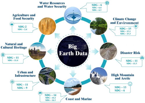
The DBAR Foci are converted into one big Earth data and eight interconnected science domains, including climate change and environment, natural disaster, water, human activities and related urban areas and infrastructure, heritage, and agriculture, and two key ecosystems, coastal and marine, and high mountains and the Arctic, respectively. The big Earth data element is a centralized platform that will draw from the DBAR community and generate data products and information services to address research and development challenges.
Related to the climate and environment issue, many B&R countries are in fragile environments and, as such, highly vulnerable to climate change. To face this challenge all ecosystem elements, for example, forest or grassland, must be monitored and their evolution accurately and objectively assessed (IPCC Citation2013). Comprehensive assessments of environmental impacts of major infrastructure development projects and monitoring implementation of mitigation measures should be a necessary condition to enable attaining SDGs.
There is indisputable evidence of strong linkages between development, environment and disasters. Sustainable development can reduce pressure on the environment and minimize disasters and their eventual impacts. In return, a well-prepared disaster risk reduction approach and environmental management can reduce the impacts of disasters on development and can make economic growth sustainable (ICSU Citation2008; UNISDR Citation2015).
Water is a vital natural resource for human livelihood and for all ecosystems including human-influenced ones such as agriculture and cities. It is an important foundation for the sustainable development of economy and society locally, nationally, regionally, and globally. Assessment of fresh water resources and their effective and sustainable use faces multiple and diverse challenges in the B&R countries in Asia, Europe, and Africa (Menenti and Jia Citation2016). The availability of quality water continues to be a major issue for the Earth system and humans, in particular. There is a growing concern that the water available in many regions of the world will not be sufficient to meet emerging demands arising from population growth, industrial expansion, and climate change.
Most of the countries along the B&R region have predominantly rural-based economies, in which the agricultural sector accounts for over 25% of their GDP and engages more than 40% of the work force. One of the major challenges faced by most food-insecure countries of the B&R is the paucity of adequate capacity in accessing up-to-date food security information. Strengthening of information systems not only requires strong technical knowledge, but also demands sustainable long-term financing, as well as human and other resources. A truly global mapping and information service, integrating spatially explicit socioeconomic data with agricultural, forest, and aquaculture data will be feasible, with applications to poverty and food monitoring, international planning, and sustainable development.
Conservation of natural and cultural heritage and their effective integration into improving socioeconomic well-being at local, national, regional, and global scales is a necessary condition for sustainable development. Natural and cultural heritage along the B&R region will face significant challenges for conservation and their potential to contribute to sustainable development, particularly in the context of massive infrastructure and economic development projects already underway or foreseen.
Urbanization and urban development across the world has profound effects on environment, biodiversity, ecological processes, and regional sustainability. Measuring and understanding the process of urbanization would help the city planners to reduce problems associated with increased urban area and high population densities, and to build sustainable cities. Many of the world’s megacities are found in the B&R countries (UN Citation2014).
The twenty-first century Maritime Silk Road strategy facilitates the connectivity between China, Southeast, South and West Asia, the Gulf States, and some eastern coastal nations of Africa. It will address a number of themes such as: marine economy, protection of coastal ecosystems, disaster management, technology innovation, and heritage and tourism development.
The high mountains and the Arctic are typical cold earth regions; these regions encompass the Qinghai-Tibet Plateau, Tian Shan, Altai Mountains, Mongolia Plateau, and the far North of Asia. Snow, ice, and permafrost dominate the local environment, transport and travel, water availability, urban and infrastructure development, and impact global climate and regional sustainability. These areas also exhibit strong sensitivity to climate change because they are some of the most fragile ecological regions. Monitoring and assessments are needed to achieve the sustainable development of the planned ‘Ice Silk Road’ along the northern coast of Russia.
3. Pressing challenges
It is well known that the B&R region spans a wide and very diverse spectrum of climate regimes. Environmental change, land degradation, and diminishing ecosystem and wildlife habitats are widespread and the causes and consequences are only partially understood. In implementing the activities that address the thematic Foci identified by the DBAR Science Plan, it will be challenging to negotiate the geographical scope of projects and actions, and reaching consensus on the balance between research, capacity building, and demonstration projects that integrate the application of big Earth data into on-going and future infrastructure development projects.
As big as DBAR’s ambitions are, it is not surprising that many obstacles may stand in the way. There are four main obstacles for the implementation of the DBAR program: a digital divide between developed and developing countries; lack of awareness among some policymakers, local scientists, and practitioners of the potential of EOs; difficulty of data access; and ineffective coordination (Guo Citation2018). In what follows, we look briefly at those impediments.
3.1. Digital divide
The scientific community has widely recognized the potential benefit of universal access to scientific data, information, and knowledge towards sustainable development by overcoming the digital divide (Iwata and Chen Citation2005). Some scientists, particularly in the developing world, struggle to find enough data to discover new knowledge, and decision-makers often lack the necessary information to articulate effective policies. While in more developed nations knowledge and acceptance of big Earth data capabilities are widespread and increasingly adopted to support all levels of society, awareness in less developed countries lags behind, potentially delaying or preventing the effective use of big Earth data.
3.2. Lack of awareness
To realize data-driven regional governance across such a diverse region, one core challenge is the common understanding of the importance of big Earth data and adaptation to an era when big data is a necessary condition for sustainable development. Lacking common awareness of their importance will, first, bring decision-makers to disregard the necessity of an appropriate research infrastructure and capacity building. It will impact policy decisions on investments, talent cultivation, data acquisition, and international cooperation. Second, the lack of such awareness can also hinder scientific researchers and research institutions in exploration of big Earth data research approaches, in terms of technologies and applications (Shu Citation2016).
3.3. Difficulty of data access
Regarding data sharing along the B&R, datasets are typically dispersed geographically and owned by various government agencies, research groups, and individuals. Stakeholders often find it difficult, if not impossible, to discover and obtain relevant and appropriate data for addressing and resolving specific problems. Even when they identify the data sources, they may not be able to obtain them due to ownership issues, or the lack of tools to successfully select, transfer, interpret, and use the data to meet their needs (Scott and Rajabifard Citation2017).
3.4. Ineffective coordination
Another challenge that remains is the lack of coordinated strategies to encourage collaboration among decision-makers, institutions, data providers, researchers, practitioners, user communities, and international organizations. Providing that coordination would facilitate the convergence of resources and applications of big Earth data to address regional challenges.
Taking disaster mitigation as an example, the region encompassing the B&R experiences about 85% of the world’s major natural hazards, leading to serious adverse impacts on human populations and infrastructure (Guo Citation2018). Severe limitations in data acquisition and sharing affect the capacity to mitigate the impact of natural disasters in the region. This unfortunate situation was illustrated by the Indian Ocean tsunami in 2004, which caused hundreds of thousands of deaths and untold suffering. The inability to access and process emergency response datasets and capabilities was a glaring problem (Iwata and Chen Citation2005).
Therefore, gaps in data infrastructure, data sharing, and use must be addressed. Advanced Big Data technologies, such as EO, or the Internet of Things, would unleash the potential of data-driven research, helping especially the developing countries, to improve capacities for addressing challenges for sustainable development.
The intent of DBAR is to address these obstacles by demonstrating how science and open access to data, information, and knowledge can make a critical difference for sustainable development by applying ‘Big Earth Data’.
4. Big Earth data solutions
With the increased use of remote sensing satellites, navigation satellites, and various other platforms, as well as diversified observation instruments and sensors, big Earth data, derived from but not limited to EO, is entering the mainstream of knowledge for understanding the Earth system (Guo, Wang, and Liang Citation2016).
In this context, it is worth reiterating that the UN has identified 17 SDGs aiming to end poverty, inequality, and to combat climate change by 2030 (UN Citation2015). Among the 17 goals, the realization of at least 8 could significantly benefit in different ways from the use of big Earth data; they are the SDGs including clean water, affordable energy, human settlements and cities, climate change, life below water, life on land, good health, and peace. Hence, big Earth data could be the new driving force powering the implementation of these UN SDGs.
Big Earth data can be defined as very large volumes of data obtained in major Earth science disciplines such as geography, geology, atmospheric science, marine science, geophysics, geochemistry, and space physics through satellite observations, ground sensor networks, and other sources (Ramapriyan et al. Citation2013; He et al. Citation2015). It is all data related to Earth’s interior, surface, atmosphere, near-space environment, and the interaction between humans and Earth. As a tool in cross-disciplinary research, big Earth data has the potential to provide a new horizon for Earth sciences, a comprehensive understanding, and dynamic simulation to support sustainable development processes. Big Earth data is already revolutionizing Earth science research by providing the means for accurate evaluation and decision support for national and international sustainable development (Vatsavai et al. Citation2012; Graham and Shelton Citation2013).
This greater potential for understanding Earth means greater technical requirements for the transmission, storage, processing, analysis, management, sharing and discovery of big Earth data. More and more researchers are devoted to studying big Earth data-oriented computing platforms, algorithms, software systems, and data sharing and service systems. Their research includes building big Earth data infrastructure to develop a multidisciplinary data and cloud service platform. The studies employ ‘data-intensive scientific discovery’ to extract information from big Earth data. They analyze and mine hidden, implicit patterns and laws by means of artificial intelligence, information theory, statistical science, and systems theory (Guo, Wang, and Liang Citation2016; Guo Citation2017a).
Following the lead in other disciplines, big Earth data is the basis of data-intensive scientific discovery in the Earth sciences (Guo Citation2017b). In the current era of big Earth data, cognition of the Earth system is transforming from collecting traditional empirical data, theoretical derivation, and simulating local physical processes to using and mining big Earth data. This new methodology explores correlation and interaction among different key information subsystems and biophysical variables in the Earth system. The transformation has been recognized as a new scientific paradigm driven by data-intensive scientific discovery (Hey, Tansley, and Tolle Citation2009).
Big data have gradually become the new engine of scientific discovery and knowledge innovation for Earth system science, but the volume of data is a major scientific issue that must be addressed in Earth sciences to help develop theories and methods. Big Earth data typically comes in large volumes at a high update rate in multiple types. Variety implies a need for better methods of fusion, and data hardening. Rate of update is problematic since speed has never been a primary concern in science. Hence, traditional data processing and scientific discovery methods are no longer applicable. Facing these challenges involves efficiently organizing massive, spatiotemporally intensive data, employing automated, intelligent computing, and efficiently mining knowledge from the data. Many governments, academic communities, industrial communities, and others have already initiated research and practices on processing, analyzing, and discovering knowledge from big Earth data (Reinsel, Gantz, and Rydning Citation2017).
Big Earth data is also bringing new opportunities for strategically addressing sustainable development challenges for society such as natural resource depletion, food and water insecurity, energy shortages, environmental degradation, disaster reduction, and population growth (Guo Citation2017b; Guo et al. Citation2017). Better stewardship of big Earth data, such as authoritative collection, long-term preservation, integrated management, data distribution, comprehensive sharing and knowledge services, will promote the great potential for in-depth development of Earth science research, especially for economic and social development needs (WEF Citation2012).
5. DBAR research implementation
The DBAR program will compile a regional spatial assessment index for the UN’s 2030 SDGs, including 8 related goals and 33 indicators, to scientifically monitor the key environmental indicators of SDGs along the B&R region, and it will establish an international big Earth data analysis and decision-making system (Guo Citation2017a). Meanwhile, DBAR’s big Earth data platform will serve as an open access and sharing gateway, providing data-driven decision support for stakeholders in the B&R countries (DBAR Citation2017). Big Earth data will serve as possible solutions to help translate the DBAR steps into reality.
5.1. Implementation framework
The implementation of the DBAR strategy reflects the common interest in a collaborative development, mutual benefit, and open data sharing. As noted above, the implementation of DBAR will be operated by an effective mechanism through a system of working groups (WGs) and task forces (TFs). Seven WGs and two TFs will take the responsibility for defining and carrying out all necessary field research and data collection in the B&R countries.
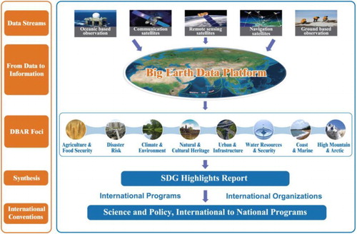
The DBAR Science Plan has been conceived to link five levels of actions: (1) link multiple data streams into an integrated, distributed data repository; (2) design and development of an ICT infrastructure to support remote discovery, access, processing and analysis of EO data in a virtual (cloud) environment; (3) research on Earth system science primarily based on EO data; (4) interaction within communities of scientific and professional stakeholders; and (5) dissemination of SDG-relevant outcomes (DBAR Citation2017).
The first level facilitates access to multiple and diverse data streams through a distributed and integrated data repository. The second level is expected to deliver a system to provide to any user in the B&R region the ICT support needed to extract information from complex and rich data streams, regardless of limitations in the computational resources available to the user. The third level includes in-situ experiments, algorithm development to retrieve surface properties and modeling of Earth system processes. The research and development activities to address the Foci will be coordinated by the WGs and TFs. The fourth level addresses the dissemination of information on project contents and achievements and the engagement of a diverse and potentially large stakeholder community in B&R countries that can claim ownership to the achievements. The fifth level entails the communication of project outcomes most relevant to support the attainment of SDGs and specific targets related to SDGs at the national, regional and global levels (DBAR Citation2017) ().
Figure 3. DBAR work flow: big Earth data platform serving DBAR Foci.
To realize the aims of DBAR, the DBAR research identifies a specific list of Tasks (T) and Actions (A) to be implemented within the program. A Task is understood as a driving guideline and strategy to be implemented throughout the program. Actions are understood as concrete steps supporting the identified tasks and the general mission and vision of DBAR.
5.2. WGs and TFs
The DBAR Foci will be addressed by a flexible system of DBAR WGs and TFs. In the start-up phase, the seven WGs will focus on: big Earth data (DBAR-DATA), Agriculture and Food Security (DBAR-AGRI), Coastal Zone (DBAR-COAST), Environmental Change (DBAR-ENVI), Natural and Cultural Heritage (DBAR-HERITAGE), Disaster Risk Reduction (DBAR-DISASTER), and Water (DBAR-WATER); Two TFs address urbanization (DBAR Urban) and high mountain and the Arctic (DBAR Cold Region). The DBAR Science Plan (DBAR Citation2017) has been completed and was unanimously adopted at the second DBAR conference held in Hong Kong in December 2017. The DBAR implementation has therefore formally been initiated.
5.3. Specific solutions
The DBAR program will develop and validate an integrated metric by combining the information currently used to evaluate 33 indicators relevant to the targets of 8 SDGs. This metric will allow monitoring the key SDG environmental indicators along the B&R region (Guo Citation2017a). The DBAR international big Earth data platform will serve as an open access and sharing gateway, providing data-driven decision support for stakeholders in the B&R countries (DBAR Citation2017).
5.3.1. A solution for analyzing massive amounts of Earth data
A huge amount of Earth data has been gathered through various means, and the rapid increase in data volume has brought data throughput pressure to the processing and analysis of big Earth data. For example, the newly launched Sentinel-5P satellite of the European Space Agency will make 20 million observations of important air pollutants and gases affecting the climate on a daily basis, which is 10 times more data than previous missions. The capabilities of traditional data management systems and processing modes hinder our ability to better use the data. Therefore, an open big Earth data infrastructure is urgently needed to provide innovative, timesaving methods for analyzing vast amounts of Earth data, which consist of multidisciplinary big Earth datasets, a high-reliability big Earth data cloud service platform, and complete-flow, fast, automatic, intelligent data processing and knowledge discovery methods. For example, it would currently take 1212 years for one computer to process 3 million planetary-scale 30-meter resolution satellite scenes, but a cloud computing facility will be able to complete the analysis in only 45 days (Hansen et al. Citation2013; He et al. Citation2015; Pekel et al. Citation2016).
5.3.2. Enhance applications at wide geographical scales
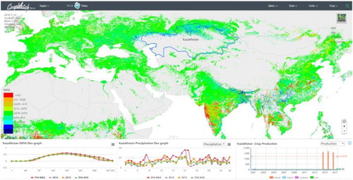
Globally there are still about 800 million people that suffer from hunger. Eradication of poverty and hunger forms the two top priorities among the 17 UN SDGs. One major challenge is the paucity of adequate capacity in accessing up-to-date food security information. A CropWatch cloud system is being developed by a DBAR WG, aiming to regularly provide free, timely, and accurate information and assessment of major global food crops through integrated Earth data. The users from 148 sub-national regions for 31 key countries are provided easy access to data for assessing and acquiring maize, rice, wheat, and soybean products for guidance on their agriculture management, giving key information to governments () (Wu et al. Citation2015).
Figure 4. Global crop information from the CropWatch cloud system (photo courtesy of DBAR-AGRI working group).
5.3.3. Make knowledge discovery possible
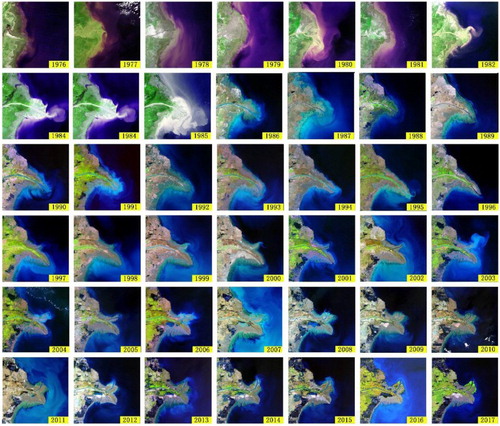
Big Earth data can be seen as a new key to understanding the world. It has great potential to promote in-depth development of Earth science though dynamic, data-intensive analysis of complex interactions and correlations among huge multidisciplinary or interdisciplinary datasets. By taking advantage of long-term time-series data, scientists of DBAR analyzed changes of the land surface of the Yellow River Delta over the past 40 years. The change information directly increased our understanding of the relationship between the geo-evolution of river deltas and land use, precipitation, construction of dams, and inter-basin water transfer, in a comprehensive and dramatic way ().
Figure 5. Over 40 years’ changes of the Yellow River Delta from a time-series dataset of Landsat satellite images for the period 1976–2017 (Image Courtesy of China Remote Sensing Satellite Ground Station).
5.3.4. DBAR applying big Earth data
The big Earth data-driven vision of DBAR program is to promote international cooperation that integrates Earth science, data, technology, and applications to facilitate sustainable development along the B&R region. Ultimately, DBAR aims to guide development along sustainable pathways and urges the open acceptance of data sharing in the big data era. The government, private sector, and individuals need to encourage building a community with a common destiny through international cooperation without barriers. Scientists, sustainable development experts, and the data itself must inspire confidence in further development. The cooperation to promote and build skills and capacities in EOs and the effective use of big Earth data platforms and frameworks for sustainable development will be a key mechanism for building ‘people-to-people’ relationships under the B&R initiative.
6. The way forward and concluding observations
In addressing the many challenges described in this article, the DBAR program will use a big Earth data approach that is made possible by the cloud-based implementation of data analysis and information extraction. A DBAR Science Plan will provide basic guidance for the implementation. Many tangible actions are now in progress and will be translating the DBAR steps into reality: first, the investment into the DBAR platform should be supported by the authorities, both internationally or nationally. The DBAR advanced data infrastructure has to be developed with links to other related EO data platforms of international organizations and programs, to optimize data, information, expertise, and knowledge brokered within the DBAR infrastructure.
Second, further identifying outstanding knowledge gaps, a comprehensive and well-articulated research programs need to be structured. The convergence of resources to support the implementation of identified projects, by collaborating with DBAR’s international partners needs to be facilitated. Improvement and harmonization of national data policies towards free access to both in-situ and spaceborne EO data must be promoted.
Third, engagement of the B&R region, through governments, institutions, universities, and even the private sectors need to be strongly encouraged through their active collaboration with the DBAR program, as big data activities require timely and thorough preparations. This applies in particular to merging and sharing EOs to capture processes relevant to understanding and promoting regional, national, and local development.
Finally, capacity building is a vital part of the DBAR program. It will be aimed at raising awareness of the role of big Earth data to address and solve problems linked to societal development and mitigation of development impact, particularly of the urbanization of natural resources, such as water. DBAR has the unique opportunity of promoting the education of the new generation of big Earth data scientists and practitioners. Deepening understanding of the smart use of EO requires promoting the formulation and adoption of data policies, which could be enhanced through capacity building (Gong et al. Citation2017).
DBAR will focus on projects and actions relevant to the implementation of all 17 UN SDGs. It will integrate ‘green’, low carbon, and sustainable approaches to social and economic growth that are vital for the implementation of international climate change and disaster reduction priorities.
Disclosure statement
No potential conflict of interest was reported by the authors.
ORCID
Huadong Guo http://orcid.org/0000-0003-0337-1862
Additional information
Funding
References
- Anderson, K., B. Ryan, W. Sonntag, A. Kavvada, and L. Friedl. 2017. “Earth Observation in the Service of the 2030 Agenda for Sustainable Development.” Geo-Spatial Information Science 20 (2): 77–96. doi: 10.1080/10095020.2017.1333230
- DBAR (Digital Belt and Road Program). 2017. “DBAR Science Plan: An International Science Program for Sustainable Development of the Belt and Road Region Using Big Earth Data.” http://www.dbeltroad.org/index.php?m=content&c=index&a=lists&catid=88.
- EMSR (The International Symposium on Earth Observation for the Maritime Silk Road). 2015. “Sanya Declaration International Symposium on Earth observation for the Maritime Silk Road.” http://www.dbeltroad.org/index.php?m=content&c=index&a=lists&catid=88.
- EOBAR (The International Symposium on Earth Observation for One Belt and One Road). 2016. “Beijing Declaration on Earth Observation for Belt and Road.” Bulletin of Chinese Academy of Sciences 30 (2): 106–107.
- Gong, J., P. Yue, T. Woldai, F. Tsai, A. Vyas, H. Wu, A. Gruen, L. Wangand, and I. Musikhin. 2017. “Geoinformatics Education and Outreach: Looking Forward.” Geo-Spatial Information Science 20 (2): 209–217. doi: 10.1080/10095020.2017.1337319
- Graham, M., and T. Shelton. 2013. “Geography and the Future of Big Data, Big Data and the Future of Geography.” Social Science Electronic Publishing 3 (3): 255–261.
- Guo, H. 2017a. “Big Earth Data: A New Frontier in Earth and Information Sciences.” Big Earth Data 1 (1–2): 4–20. doi: 10.1080/20964471.2017.1403062
- Guo, H. 2017b. “Big Data Drives the Development of Earth Science.” Big Earth Data 1 (1–2): 1–3. doi: 10.1080/20964471.2017.1405925
- Guo, H. 2018. “Steps to the Digital Silk Road.” Nature 554: 25–27. doi: 10.1038/d41586-018-01303-y
- Guo, H., Z. Liu, H. Jiang, C. Wang, J. Liu, and D. Liang. 2017. “Big Earth Data: A New Challenge and Opportunity for Digital Earth’s Development.” International Journal of Digital Earth 10 (1): 1–12. doi: 10.1080/17538947.2016.1264490
- Guo, H., L. Wang, and D. Liang. 2016. “Big Earth Data from Space: A New Engine for Earth Science.” Chinese Science Bulletin 61 (7): 505–513.
- Guo, H., and H. Xiao. 2016. “Earth Observation for the Belt-road and Digital Belt-road Initiative.” Bulletin of Chinese Academy of Sciences 31 (5): 535–541.
- Hansen, M. C., P. V. Potapov, R. Moore, M. Hancher, S. A. Turubanova, A. Tyukavina, D. Thau, et al. 2013. “High-resolution Global Maps of 21st-century Forest Cover Change.” Science 342: 850–853. doi: 10.1126/science.1244693
- He, G., L. Wang, Y. Ma, Z. Zhang, G. Wang, Y. Peng, T. Long, and X. Zhang. 2015. “Processing of Earth Observation Big Data: Challenges and Countermeasures.” Chinese Science Bulletin 60: 470–478. doi: 10.1360/N972014-00907
- Hey, T., S. Tansley, and K. Tolle. 2009. The Fourth Paradigm: Data Intensive Scientific Discovery. Washington, DC: Microsoft Research.
- ICSU (International Council for Science). 2008. “A Science Plan for Integrated Research on Disaster Risk: Addressing the Challenge of Natural and Human-induced Environmental Hazards.” https://www.icsu.org/publications/a-science-plan-for-integrated-research-on-disaster-risk.
- IPCC. 2013. Climate Change 2013: The Physical Science Basis. Contribution of Working Group I Contribution to the Fifth Assessment Report of the Intergovernmental Panel on Climate Change. Edited by T. F. Stocker, D. Qin, G.-K. Plattner, M. Tignor, S. K. Allen, J. Boschung, A. Nauels, Y. Xia, V. Bex, and P. M. Midgley. Cambridge: Cambridge University Press. 1535 pp. doi:10.1017/CBO9781107415324.
- ISEO (International Symposium on Earth Observation for Arid and Semi-Arid Environments). 2012. “Kashgar Declaration on the International Cooperation on Earth Observation in Central Asia.” http://www.dbeltroad.org/index.php?m=content&c=index&a=lists&catid=88.
- Iwata, S., and R. S. Chen. 2005. “Science and the Digital Divide.” Science 310: 405. doi: 10.1126/science.1119500
- Menenti, M., and L. Jia. 2016. “Driving Mechanisms of Land Use and Cover Change in the Sahel: Impacts and Responses (DIMECLUS).” The 11th International Conference of the African Association of Remote Sensing of the Environment, Kampala, Uganda.
- NDRC (National Development and Reform Commission), MFA (Ministry of Foreign Affairs), and MOFCOM (Ministry of Commerce) of the People's Republic of China. 2015. “Vision and Action on Jointly building Silk Road Economic Belt and 21st-century Maritime Silk Road.” http://en.ndrc.gov.cn/newsrelease/201503/t20150330_669367.html.
- Pekel, J., A. Cottam, N. Gorelick, and A. S. Belward. 2016. “High-resolution Mapping of Global Surface Water and Its Long-term Changes.” Nature 540: 418–422. doi: 10.1038/nature20584
- Ramapriyan, H., J. Brennan, J. Walter, and J. Behnke. 2013. “Managing Big Data: NASA Tackles Complex Data Challenges.” Earth Imaging Journal. Accessed October 30, 2016. http://eijournal.com/print/articles/managing-bigdata.
- Reinsel, D., J. Gantz, and J. Rydning. 2017. “Data Age 2025: The Evolution of Data to Life-critical.” IDC: Analyze the Future.
- Scott, G., and A. Rajabifard. 2017. “Sustainable Development and Geospatial Information: a Strategic Framework for Integrating a Global Policy Agenda Into National Geospatial Capabilities.” Geospatial Information Science 20 (2): 59–76. doi: 10.1080/10095020.2017.1325594
- Shu, H. 2016. “Big Data Analytics: Six Techniques.” Geo-Spatial Information Science 19 (2): 119–128. doi: 10.1080/10095020.2016.1182307
- UN (United Nations). 2015. “Transforming Our World: The 2030 Agenda for Sustainable Development.” A/RES/70/1. Accessed February 17, 2016. http://www.un.org/ga/search/view_doc.asp?symbol=A/RES/70/1&Lang=E.
- UN (United Nations). Department of Economic and Social Affairs, Population Division. 2014. “World Urbanization Prospects: The 2014 revision, Highlights.” ST/ESA/SER.A/352.
- UNFCCC (United Nations Framework Convention on Climate Change). 2015. “Adoption of the Paris Agreement.” FCCC/CP/2015/L.9/Rev.1. Accessed February 17, 2016. https://unfccc.int/resource/docs/2015/cop21/eng/l09r01.pdf.
- UNISDR (United Nations International Strategy for Disaster Reduction). 2015. “Sendai Framework for Disaster Risk Reduction 2015–2030.” Geneva: United Nations. Accessed February 17, 2016. http://www.preventionweb.net/files/43291_sendaiframeworkfordrren.pdf.
- Vatsavai, R. R., A. Ganguly, V. Chandola, A. Stefanidis, S. Klasky, and S. Shekhar. 2012. “Spatiotemporal Data Mining in the Era of Big Spatial Data: Algorithms and Applications.” Paper presented at the ACM Sigspatial International Workshop on Analytics for Big Geospatial Data, Redondo Beach, California.
- WEF (World Economic Forum). 2012. Big Data, Big Impact: New Possibilities for International Development. World Economic Forum Report. http://www3.weforum.org/docs/WEF_TC_MFS_BigDataBigImpact_Briefing_2012.pdf.
- Wu, B., R. Gommes, M. Zhang, H. Zeng, N. Yan, W. Zou, Y. Zheng, et al. 2015. “Global Crop Monitoring: A Satellite-based Hierarchical Approach.” Remote Sensing 7 (4): 3907–3933. doi: 10.3390/rs70403907