
ABSTRACT
Earth observation data sharing is an essential part of the data lifecycle and plays a critical role in Earth science research. Existing industry data sharing systems are affected by restrictions in distributed resource management and tightly coupled service interoperability. These systems currently offer no support for facilitating cross-disciplinary exploration and application. The lack of a national data sharing infrastructure has led to reduced international cooperation. These barriers are common and have hindered the development of the Global Earth Observation System of Systems (GEOSS). The China GEOSS Data Sharing Network (China GEOSS DSNet) has been proposed as a part of China’s Plan for Implementing GEOSS (2016–2025) to address the above issues. In this research, we designed a national GEOSS data sharing framework, including resource integration mechanism, sharing-oriented metadata standards, and lightweight interoperability service to coordinate various Earth observation resources. So far, more than 29 million archived satellite metadata records and 200 TB of high-quality satellite datasets have been integrated under this framework. The results were demonstrated in the following applications: domestic satellite archived metadata query service, international Earth observation resource sharing service, and disaster emergency response service.
1. Introduction
For decades, Earth observation data has been an important component of Earth science research. Observation data has been considered an essential prerequisite for measuring and monitoring Earth’s physical, chemical, and biological systems (Beniston et al. Citation2012; Nativi et al. Citation2013). This type of data represents intangible assets with potential value beyond immediate research use, and therefore needs to be properly managed throughout the data lifecycle (Faundeen et al. Citation2013). The data lifecycle usually consists of many stages, including planning, acquisition, processing, analysis, preservation, publishing, and sharing. The life cycle is increasingly gaining recognition as an effective management strategy for the allocation and utilization of Earth observation resources. The goal of data sharing is to facilitate data reuse and to avoid developing excess cyber-infrastructure (Giuliani et al. Citation2017). Access to data applications are no longer restricted by providers and other stakeholders, and are now available to researchers, decision makers, and the public (Li et al. Citation2016). Therefore, Earth observation data sharing has become a key to promoting sustainable development of international science programs such as the Digital Belt and Road Program (DBAR) (Guo Citation2018).
China has launched a series of Earth observation satellites, including FY, CBERS, HJ, ZY, SJ, and GF (Xu, Gong, and Wang Citation2014), to expand its capacity for collecting Earth observation data. Satellite data are widely used in land resources monitoring, disaster reduction, agriculture, forestry, and environmental protection. However, existing industry data sharing systems have caused restrictions in distributed resource management and the interoperability of tightly coupled services. Furthermore, the lack of a national data sharing infrastructure has led to reduced international cooperation. In this paper, we propose a Chinese GEOSS Data Sharing Network (GEOSS DSNet) framework to address the above issues. The framework focuses primarily on Earth observation resource integration mechanisms, sharing-oriented metadata standards, and lightweight service middleware. Three applications are used to demonstrate the effectiveness of the framework, including domestic satellite archived metadata query service, international Earth observation resource sharing service, and disaster emergency response service.
2. Background
In the mid-1990s, grid technology was adopted in scientific computing due to the popularization of networks. It can connect multiple geographically distributed resources, including databases, storage, and software for collaborative work through standardized protocols (Foster and Kesselman Citation1999). The United States was the first country to share Earth observation resources based on grid technology. The National Science Foundation (NSF), Department of Energy (DOE), Department of Defense (DOD), and the National Aeronautics and Space Administration (NASA) have each provided funds for the construction of grid systems (Foster, Kesselman, and Tuecke Citation2001). European countries have also implemented projects to build various grid infrastructure such as the Network for Earthquake Engineering Simulation (http://www.neesgrid.org) and the Particle Physics Data Grid (http://www.ppdg.net) (Foster et al. Citation2002). Grid architecture has evolved gradually from Five-Level Sandglass Architecture (FLSA) to Open Grid Services Architecture (OGSA). However, each grid has a set of independent metadata standards and service interface specifications. They are tightly coupled with internal business systems, which makes it difficult to implement the discoveries of diverse Earth observation resources.
In 2005, the Open Geospatial Consortium (OGC) released the Catalogue Services Interface Standard (CAT) to achieve the interoperability of spatial resources. The standard is bound by protocols such as Z39.50, CORBA/IIOP, or HTTP. It can also be extended to a specific catalogue service using protocol and metadata information mechanisms such as ISO 19115/19119 and ebRIM (Hu et al. Citation2008). The OGC/CSW is a web-based catalogue service and defines seven standard interfaces. Data providers can register, organize, manage, and publish metadata for Earth observation resources through a catalogue service. Data consumers can also query and obtain the metadata from the catalogue service. Currently, an increasing number of data centers encapsulate Earth observation resources in a service mode based on the OGC/CSW standard. For example, the United States National Oceanic and Atmospheric Administration’s Comprehensive Large Array-data Stewardship System (CLASS) (http://www.class.ngdc.noaa.gov) manages and customizes services for various polar and meteorological satellite observations and products. The Landsat catalogue system of the United States Geological Survey (USGS) (https://earthexplorer.usgs.gov/) provides more than 2.8 million satellite images, and is the world’s largest medium-resolution satellite resource. However, the OGC/CSW standard requires that all data services adopt the same metadata description. It is not compatible with common catalogue specifications for different industries, making it difficult for cross-industry data sharing and Earth observation resource interoperability. As a result, the central metadata management mechanism cannot update the catalogue records in a timely manner. The records stored in the catalogue only reflect the status of the last recorded update. Therefore, there is an urgent need to achieve the dynamic binding of cross-industry catalogue services without changing existing industry data management systems.
In 2006, NASA released the Earth Observing System ClearingHOuse (ECHO) to enhance the discovery and access to Earth observation resources (Esfandiari et al. Citation2007). ECHO is a service middleware that serves as an intermediary between data providers and users. The functions of the middleware include establishing a virtual data exchange environment, translating the user’s query conditions through a metadata conversion interface, and harvesting records from each data center’s internal business system. It preserves the independence of existing data center systems and ensures the security management of the local dataset. Earth observation resources gathered from land, ocean, the atmosphere, and biosphere are rapidly increasing. Currently, ECHO has achieved interoperability between NASA and other research institutions in the United States, and an increasing number of international cooperation organizations are joining this system. However, ECHO only realizes the sharing of multi-source Earth observation data, while service interoperability has not been considered yet.
In 2012, the GEOSS Common Infrastructure (GCI) was launched by the Group on Earth Observations (GEO) (Nativi, Craglia, and Pearlman Citation2013). It consists of the following components: Standards and Interoperability Registry, Component and Service Registry, Clearinghouse, and GEOSS portal. The Standards and Interoperability Registry maintains a list of interoperability protocols. It requires data providers to reveal information about their system interfaces, operating standards, and configuration parameters so that other systems can use their system services. The Component and Service Registry is the master directory of all sharable Earth observation resources. The Clearinghouse uses a distributed search to make metadata information about the Earth observation resources available through the application programing interface (API). The GEOSS portal presents a graphical user interface (GUI) for users to discover the Earth observation resources of interest (Bai et al. Citation2012). In 2017, the GCI maintained a GEOSS Platform that better served data users, and housed customizable instruments and services for diverse user communities (http://www.earthobservations.org).
In the past few years, China has established a series of industrial Earth observation data service systems (Li and Pang Citation2017). However, existing data sharing systems often rely on industry project cycles, and do not provide a sustainable development strategy for data sharing. Moreover, the lack of a national data sharing infrastructure has also restricted cross-disciplinary exploration and application. A novel isolated data island has gradually emerged and is reflected by:
The lack of diverse resource integration mechanisms. China has established many civil and commercial satellite agencies (Xu, Gong, and Wang Citation2014). More than 3PB of archived domestic satellite metadata records can be discovered and accessed by their independent data sharing systems. Moreover, an increasing number of scientific analysis products are also generated by various national science and technology programs every year. Traditional central storage mechanisms for entity data not only maintain large databases, but also guarantee updates for satellite information.
The lack of sharing-oriented metadata standards. Metadata is a description of Earth observation data and is developed for industry applications by data providers. Currently, users must login to different data sharing systems to query, order, and access data through heterogeneous interfaces. These service interfaces are tightly coupled with independent systems, which makes it difficult to enhance data values for deep excavations.
The lack of national data sharing infrastructure. Although China has the largest number of Earth observation satellites, there is a large gap between data requirements and data acquisition at the national level. This gap directly affects the service quality for different data consumers. The fragmentation of international services has also restricted the exchange and contribution of high-quality international Earth observation resources.
The Global Earth Observation System of Systems (GEOSS) data sharing principles have been recognized as an effective strategy for designing national, regional, and global GEOSS infrastructure. It includes (1) a full and open exchange of data, metadata, and products shared within GEOSS, recognizing relevant international instruments and national policies and legislation. (2) All shared data, metadata, and products are made available with minimal time delay and cost. (3) All shared data, metadata, and products are free of charge or are no more than the cost of reproduction. Thus, these products are encouraged to be used for research and education (http://www.earthobservations.org). China GEOSS DSNet will be designed based on these data sharing principles, including the three following aspects. (1) The DSNet will promote and organize Chinese Earth observation resources to participate in regional and global GEOSS activities. (2) The DSNet will connect to the GEOSS Platform to realize data sharing and management principles for information integration. (3) The DSNet will consider the requirements of a country’s sustainable development and co-design GEO support for administrators.
3. Approach
3.1. Earth observation resource integration mechanism
The aim of China GEOSS DSNet is to integrate various Earth observation resources and offer full open access to comprehensive data sharing services. Currently, Chinese Earth observation data providers can be divided into four categories: civil satellite agency, commercial satellite agency, scientific data analysis agency, and scientific product management agency. These agencies are listed in .
Table 1. Chinese Earth observation resource agencies.
These agencies are widely distributed and independent, thus it is difficult to integrate their resources. Therefore, China GEOSS DSNet aims to promote interoperability by incorporating eight integration mechanisms ().
Figure 1. Relationship between Earth observation resources and integration mechanisms in China GEOSS DSNet.
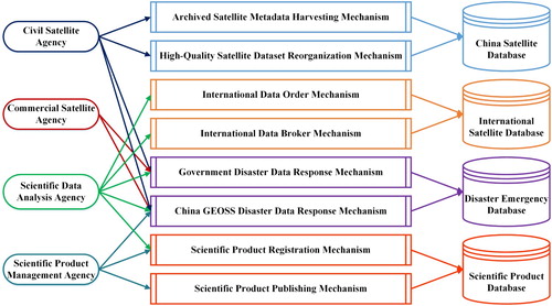
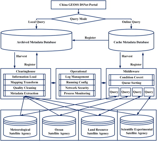
The Archived Satellite Metadata Harvesting Mechanism (ASMHM), as the core mechanism of China GEOSS DSNet, is responsible for maintaining a central metadata database and regularly harvesting archived metadata records from civil satellite agencies. It develops a loose coupling relationship with them through web service interfaces. All archived metadata must be extracted, cleaned, transformed, and loaded in accordance with the central metadata database standards due to the diversity and variability of satellite metadata. China GEOSS DSNet adopts online metadata query translation and mapping approach to overcome the long update cycle of metadata harvesting. The user’s query conditions are translated to the internal system of each satellite agency, and then a metadata list is collected and registered to the ASMHM ().
Figure 2. Archived Satellite Metadata Harvesting Mechanism (ASMHM).
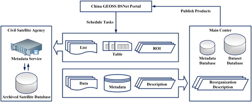
Chinese Earth observation satellite dataset is considered the most important resource in China GEOSS DSNet. Through the High-Quality Satellite Dataset Reorganization Mechanism (HQSDRM), all civil satellite agencies have been encouraged to provide a series of high-quality dataset based on regional spatial range, stable sensor type, and mature reorganization method. High-quality satellite datasets account for only 1%–3% of all archived data, but the scientific value and reuse rates are high in scientific research and applications ().
Figure 3. High-Quality Satellite Dataset Reorganization Mechanism (HQSDRM).
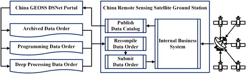
Chinese Earth observation satellites have developed rapidly over the last few years, though they have several issues, including unstable equipments, single optical sensors, short life spans, and poor quantitative observation capability. However, if users choose to download directly from international data providers, there is a slow download speed and high storage cost. Thus, China GEOSS DSNet adopts an International Data Order Mechanism (IDOM) to provide localization services. China’s Remote Sensing Satellite Ground Station (RSGS) is a member of the international ground stations group for Earth observation. The RSGS has been authorized by the United States Geological Survey (USGS) as a mirrored site to receive, process, and distribute Landsat series satellite data. China GEOSS DSNet establishes a data order with RSGS to help users access satellite data. When a data order is submitted to the GEOSS DSNet portal, it is recompiled into an internal order and executed by the business system within RSGS. The data is stored on the cache server which users can access via download links ().
Figure 4. International Data Order Mechanism (IDOM).
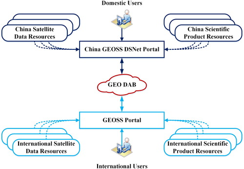
The GEO Discovery and Access Broker (DAB) is a key component of the GEOSS Platform. It transparently connects GEOSS user’s requests to resources shared by GEOSS providers (Nativi et al. Citation2015; Santoro, Nativi, and Mazzetti Citation2016). China GEOSS DSNet successfully interconnects hundreds of heterogeneous and autonomous international satellite operation systems based on GEO DAB. This is performed using the International Data Broker Mechanism (IDBM). It provides Chinese Earth observation resources to both China and the international community ().
Figure 5. International Data Broker Mechanism(IDBM).
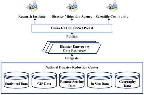
The National Disaster Reduction Center of China (NDRCC) acquires information and supports decision making during disasters (Ding et al. Citation2015). The NDRCC is responsible for collecting, managing, analyzing, and evaluating disaster information from agreement members following a natural disaster (Fan et al. Citation2017). Disaster information is not only released through its own portal to disaster management departments, but it is also available through China GEOSS DSNet portal to the public via the Government Disaster Data Response Mechanism (GDDRM). Users from research institutes and scientific communities can query and access the data for related functions, such as disaster preparedness and reduction, emergency response, and post-disaster rehabilitation and reconstruction ().
Figure 6. Government Disaster Data Response Mechanism (GDDRM).
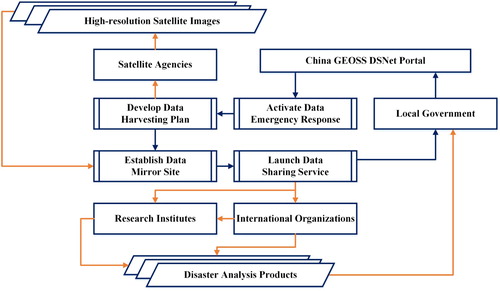
One of the core tasks for disaster emergency assistance is the acquisition of accurate damage information and loss assessment. China GEOSS DSNet will use the China GEOSS Disaster Data Response Mechanism (CDDRM) to provide valuable information requested by GEO members and local governments. The mechanism is responsible for coordinating civil and commercial satellite agencies to contribute high-resolution satellite data and analysis products. All resources are based on GEO data sharing principles and are registered with the GEOSS Platform. These resources can be made available to any user with the GEOSS portal. Furthermore, China GEOSS DSNet will work together with international organizations and research institutes to produce valuable damage analysis products and information. This mechanism will increase communication and coordination between national and international communities to improve disaster management ().
Figure 7. China GEOSS Disaster Data Response Mechanism (CDDRM).
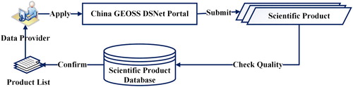
In China, many scientific analysis products are generated every year in various national science and technology support programs. These products are not only the core component of the research program, but they are also an important foundation for science and technology innovation. However, most products are dispersed among scientific research institutes, universities, and individual scientists. China GEOSS DSNet adopts a mandatory registration mechanism, or Scientific Product Registration Mechanism (SPRM), to promote sharing of scientific products. The mechanism is usually implemented by the National Remote Sensing Center of China (NRSCC) ().
Figure 8. Scientific Product Registration Mechanism (SPRM).
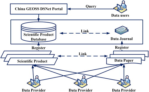
Publishing scientific products in the form of data journals enables the author to focus on the data, rather than producing an extensive analysis that occurs in a traditional journal model. Currently, China GEOSS DSNet adopts a Digital Object Identifier (DOI) to establish links between scientific and paper data. The Scientific Product Publishing Mechanism (SPPM) not only protects the author’s intellectual property rights, but also improves the transparency of the scientific method ().
Figure 9. Scientific Product Publishing Mechanism (SPPM).
3.2. Sharing-oriented metadata standards
Metadata is an index that is used to describe the content, space-time scale, quality, and format of data. It provides an effective means for organizing and managing Earth observation resources. However, various metadata types are known to cause difficulty in the integrated management of multi-source Earth observation data. Therefore, it is necessary to develop a widely accepted and sharing-oriented metadata standard.
ISO19115 is a geo-metadata standard that was published in 2003 by the International Organization for Standardization (ISO). It mainly defines metadata patterns to describe the identification, quality, space, time, content, spatial reference, distribution, and other attributes of geographic information and services (Devarakonda et al. Citation2010). ISO 19115-2 is the second part of the ISO 19115 standard, providing information on the acquisition of remote sensing data. It also provides a band description of remote sensing data for the expansion of image and grid data. It has become one of the standards used by international geographic information organizations and geographic data centers for the exchange, integration, and retrieval of geographic information (Di, Shao, and Kang Citation2013).
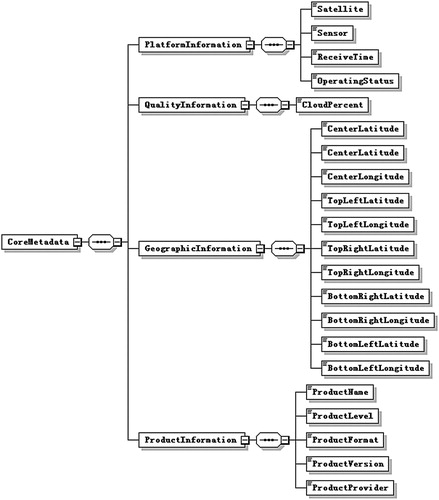
China GEOSS DSNet establishes a set of sharing-oriented metadata standards to integrate metadata from heterogeneous Earth observation resources. These are based on the ISO 191152:2009 geo-information metadata standard. The sharing-oriented metadata standards describe common information items extracted from different resource metadata descriptions, which are different in syntax but semantically consistent. These items consist of twenty-one attributes, including platform parameter information, spatial reference information and data quality information. The items meet the ‘one-stop’ user query requirement for multi-source satellite data ().
Figure 10. Sharing-oriented metadata standards included in China GEOSS DSNet.
3.3. Lightweight interoperability service
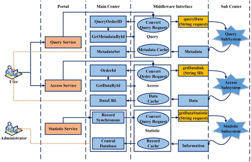
China GEOSS DSNet adopts three lightweight service middleware products to perform interoperability functions for data queries, access, and statistics. The middleware considers system security and firewall restrictions and is deployed in the demilitarized zone (DMZ) of each sub-center. It is responsible for invoking the subsystems for queries, access, and statistics. This operation mechanism helps the main center and sub-centers maintain a loose coupling relationship. It also achieves an interaction between the internal production process and the extranet sharing service ().
China GEOSS DSNet adopts an XML format order to encapsulate the query conditions (e.g. satellite, sensor, receive time, and geospatial range). The metadata query middleware converts the order to a SQL string and submits it to the query subsystem in sub-centers. The service considers the complexity of query lists and is asynchronously executed by middleware. Users first obtain the information for a total number of metadata and a Metadata ID, and then receive the metadata in batches to avoid memory overflow.
The data access middleware is responsible for passing the order from the GEOSS DSNet portal to the access subsystem in the sub centers. The service considers the complexity of the access results as asynchronously executed by the middleware. The data is stored in the cache directory and a download link is provided to the user after the order is completed.
The information statistics middleware is responsible for regularly harvesting archived satellite metadata from each data center and providing statistical results to the main center. It uses an incremental updating approach to synchronize metadata between the central database and each sub center database.
4. Application
4.1. Operational architecture
The Ministry of Science and Technology (MOST) has been directed under the leadership of the China GEO Inter-Ministerial Coordination Group to organize 19 ministries that engage in all the activities related to Earth observation. The group has established a national GEOSS system (China GEOSS DSNet) to provide a one-stop Earth observation data sharing service.
Figure 11. Workflow of the lightweight interoperability service.
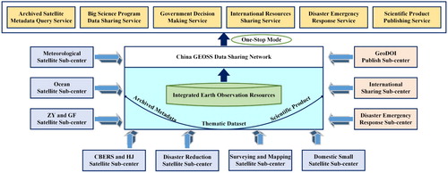
The operational architecture of China GEOSS DSNet is shown in . It is composed of one main center and ten sub-centers. The National Remote Sensing Center of China (NRSCC), as the main center, is responsible for managing the central metadata database and coordinating various Earth observation resources. Seven civil satellite agencies and three scientific agencies comprise the sub-centers ().
Figure 12. Operational architecture of China GEOSS DSNet.
4.2. Domestic satellite archived metadata query service
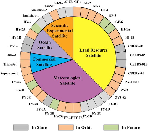
The main center of China GEOSS DSNet can directly invoke the service interface of domestic satellite sub-centers to harvest archived metadata records. As a virtual integration mechanism, it can effectively utilize the hardware, software, and network infrastructures of existing industry data sharing systems. Furthermore, the main center has a loose coupling relationship and scalability with the internal service system of the satellite sub-centers. This can enable real-time queries and access to the latest satellite metadata records without changing the frameworks of internal business systems. Currently, China GEOSS DSNet has connected six satellite agencies, including the National Satellite Meteorological Center (NSMC), National Satellite Ocean Application Center (NSOAS), China Centre for Resources Satellite Data and Application (CRESDA), Satellite Surveying and Mapping Application Center (SASMAC), China’s Remote Sensing Satellite Ground Station (RSGS), and the Twenty-First Century Aerospace Technology Co., Ltd. (21AT). More than 29 million metadata records and 200 TB of high-quality satellite datasets have been successfully harvested from meteorological, ocean, land resources, commercial, and scientific experimental satellites ().
Figure 13. Classification of domestic satellite metadata in China GEOSS DSNet.
4.2.1 International earth observation resource sharing service
China GEOSS DSNet provides two query methods due to the differences between the Chinese and English languages, including a key word query for the Chinese portal (http://www.chinageoss.org) and dataset query for the English portal (http://www.chinageoss.org/en).
After receiving the data providers’ authorition, China GEOSS DSNet will annually select high-quality Earth observation datasets from domestic satellite data and scientific products and publish the metadata records to the GEOSS Platform. As of January 2018, more than 1.1 million Chinese Earth observation resources can be discovered, queried and accessed in the GEOSS portal ( and ).
Table 2. Types of Chinese satellite data available in the GEOSS portal (http://www.geoportal.org).
Table 3. Types of Chinese scientific products available in the GEOSS portal (http://www.geoportal.org).
4.3. Disaster emergency response service
China GEOSS Disaster Data Response Mechanism (CDDRM) will increase prevention, response, and recovery capabilities for disaster management. At the data acquisition stage, it is responsible for integrating pre- and post-disaster high-resolution satellite data from civil and commercial satellite agencies (). Accordingly, the disaster emergency service portal is released to query metadata information at the data sharing stage. International users can access on-demand data from different regional mirror sites in Asia, Europe, and American. At the data application stage, the mechanism works together with scientific research institutes to rapidly map casualties and damages, and identify safe areas.
Figure 14. The number of Chinese Satellites in four disaster emergency response services (http://www.chinageoss.org).
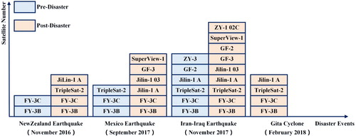
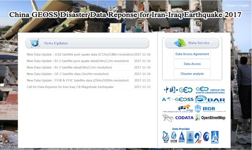
More than seven satellite agencies and twelve domestic satellites have been involved in four international disasters (the New Zealand earthquake in November 2016, the Mexico earthquake in September 2017, the Iran-Iraq earthquake in November 2017 (), and Gita cyclone in February 2018). These services have been regarded as a best practice for GEO-based emergency response under the Sendai framework, coinciding with government-level mechanisms.
Figure 15. Iran-Iraq earthquake data response service based on CDDRM (http://www.chinageoss.org/IranIraqEarthQuake2017/en/index.html).
5. Conclusion
In this paper, a comprehensive approach was presented for integrating Earth observation resources with data sharing in China GEOSS. This approach was designed to eliminate bottlenecks in existing industry data sharing systems. A novel GEOSS Data Sharing Network, China GEOSS DSNet, was introduced to focus on the integration, collaboration, and reuse of Chinese Earth observation resources to better support stakeholders. The network functions by incorporating holistic Earth observation resource management. The following lessons can be learned from the national GEOSS system.
The construction of a national GEOSS system involves complicated system engineering. A common integration mechanism cannot realize the comprehensive management of various Earth observation resources. Therefore, system design should incorporate diverse integration mechanisms to strengthen the application of Earth observation resources in cross-industry fields.
Data sharing policies represent the relationships among stakeholders. Although GEO data sharing principles have been widely accepted, it is necessary to consider the interests of data providers and consumers. Therefore, data sharing not only requires technological solutions, but also human and institutional changes to make collected data available.
The number of high-quality satellite datasets available is an important indicator of the development of data sharing services. Currently, the Discrete Global Grid System (DGGS) is a new OGC standard that has been proposed for use in a wide range of geospatial applications. It may be the best way to generate Analysis Ready Data (ARD) in China GEOSS DSNet. DGGS can reduce the magnitude of data processing for application scientists and provide the capability for integrating global geospatial, social, and economic information.
Satellite metadata is not only an overview of data information, but also represents policy information. This information helps to assign different levels of authorization to the user. Authorization standards include national or international, professional or public, and data provider or consumer.
Acknowledgements
The authors would like to thank the editors and anonymous reviewers for their valuable comments and suggestions. We also would like to thank Jing Li and Xiaochuang Yao for helpful discussions.
Disclosure statement
No potential conflict of interest was reported by the authors.
Additional information
Funding
References
- Bai, Y., L. Di, D. Nebert, A. Chen, Y. Wei, X. Cheng, Y. Shao, D. Shen, R. Shrestha, and H. Wang. 2012. “GEOSS Component and Service Registry: Design, Implementation and Lessons Learned.” IEEE Journal of Selected Topics in Applied Earth Observations and Remote Sensing 5 (6): 1678–1686. doi:10.1109/JSTARS.2012.2215914.
- Beniston, M., M. Stoffel, R. Harding, M. Kernan, R. Ludwig, E. Moors, P. Samuels, and K. Tockner. 2012. “Obstacles to Data Access for Research Related to Climate and Water: Implications for Science and EU Policy-making.” Environmental Science and Policy 17: 41–48. doi:10.1016/j.envsci.2011.12.002.
- Devarakonda, R., G. Palanisamy, B. E. Wilson, and J. M. Green. 2010. “Mercury: Reusable Metadata Management, Data Discovery and Access System.” Earth Science Informatics 3: 87–94. doi:10.1007/s12145-010-0050-7.
- Di, L., Y. Shao, and L. Kang. 2013. “Implementation of Geospatial Data Provenance in a Web Service Workflow Environment With ISO 19115 and ISO 19115-2 Lineage Model.” IEEE Transactions on Geoscience and Remote Sensing 51 (11): 5082–5089. doi:10.1109/TGRS.2013.2248740.
- Ding, Y., Y. Fan, Z. Du, Q. Zhu, W. Wang, S. Liu, and H. Lin. 2015. “An Integrated Geospatial Information Service System for Disaster Management in China.” International Journal of Digital Earth 8 (11): 918–945. doi:10.1080/17538947.2014.955540.
- Esfandiari, M., H. Ramapriyan, J. Behnke, and E. Sofinowski. 2007. “Earth Observing System (EOS) Data and Information System (EOSDIS)-evolution Update and Future.” Proc. IEEE International Geoscience and Remote Sensing Symposium: 4005–4008. doi:10.1109/IGARSS.2007.4423727.
- Fan, Y., Q. Wen, W. Wang, P. Wang, L. Li, and P. Zhang. 2017. “Quantifying Disaster Physical Damage Using Remote Sensing Data-A Technical Work Flow and Case Study of the 2014 Ludian Earthquake in China.” International Journal of Disaster Risk Science 8 (4): 471–488. doi:10.1007/s13753-017-0143-8.
- Faundeen, J., T. Burley, J. Carlino, D. Govoni, H. Henkel, S. Holl, V. Hutchison, et al. 2013. “The United States Geological Survey Science Data Lifecycle Model.” U.S. Geological Survey Open-File Report: 2013–1265.
- Foster, I., and C. Kesselman. 1999. “The Grid: Blueprint for a New Computing Infrastructure.”
- Foster, I., C. Kesselman, J. Nick, and S. Tuecke. 2002. “Grid Services for Distributed System Integration.” IEEE Computer 35 (6): 37–46. doi:10.1109/MC.2002.1009167.
- Foster, I., C. Kesselman, and S. Tuecke. 2001. “The Anatomy of the Grid: Enabling Scalable Virtual Organizations.” The International Journal of High Performance Computing Applications 15 (3): 200–222. doi:10.1109/CCGRID.2001.923162 doi: 10.1177/109434200101500302
- Giuliani, G., P. Lacroix, Y. Guigoz, R. Roncella, L. Bigagli, M. Santoro, P. Mazzetti, S. Nativi, N. Ray, and A. Lehmann. 2017. “Bringing GEOSS Services into Practice: A Capacity Building Resource on Spatial Data Infrastructures (SDI).” Transactions in GIS 21 (4): 811–824. doi:10.1111/tgis.12209.
- Guo, H. 2018. “Steps to the Digital Silk Road.” Nature 554: 25–27. doi: 10.1038/d41586-018-01303-y
- Hu, C., L. Di, W. Yang, Y. Wei, Y. Bai, C. Lynnes, Y. Enloe, B. Domenico, and G. Rutledge. 2008. “Interoperability Middleware between Geoscience and Geospatial Catalog Protocols.” Proc. IEEE International Geoscience and Remote Sensing Symposium 5: 89–92. doi:10.1109/IGARSS.2008.4780034.
- Li, G., and L. Pang. 2017. "A New Age of Public-oriented Earth Observation Development (in Chinese)." Scientia Sinica Informations 47 (2): 193–206. doi:10.1360/N112016-00127.
- Li, G., H. Zhang, L. Zhang, Y. Wang, and C. Tian. 2016. “Development and Trend of Earth Observation Data Sharing.” Journal of Remote Sensing 20 (5): 979–990. doi:10.11834/jrs.20166173.
- Nativi, S., M. Craglia, and J. Pearlman. 2013. “Earth Science Infrastructures Interoperability: The Brokering Approach.” IEEE Journal of Selected Topics in Applied Earth Observations and Remote Sensing 6 (3): 1118–1129. doi:10.1109/JSTARS.2013.2243113.
- Nativi, S., P. Mazzetti, M. Santoro, F. Papeschi, M. Craglia, and O. Ochiai. 2015. “Big Data Challenges in Building the Global Earth Observation System of Systems.” Environmental Modelling and Software 68: 1–26. doi:10.1016/j.envsoft.2015.01.017.
- Santoro, M., S. Nativi, and P. Mazzetti. 2016. “Contributing to the GEO Mechanism Web Implementation: A Brokering Service for Business Processes.” Environmental Modelling and Software 84: 18–34. doi:10.1016/j.envsoft.2016.06.010.
- Xu, W., J. Gong, and M. Wang. 2014. “Development, Application, and Prospects for Chinese Land Observation Satellites.” Geo-spatial Information Science 17 (2): 102–109. doi:10.1080/10095020.2014.917454.