
ABSTRACT
Urbanization is one of the most important social and economic phenomena in the world today. This paper reviews the formation of megacities and summarizes the main problems, challenges and opportunities faced by the sustainable development of such large megacities. Issues discussed include the problems of land subsidence in megacities, environmental issues, traffic problems and energy supply aspects. The sustainable development of megacities in other parts of the world provided the references and experiences for the countermeasures of megacity planning and development in China. The vision of Digital Earth and Digital Cities can play a major role in the efficient management and sustainable growth of such megacities all around the world.
1. Formation of megacities
The city plays an important role in social development and carries most of the functions of human social, economic and cultural activities. In some sense, it is the crystallization and engine of social and cultural change. Urbanization is one of the most important phenomena of society and the economy in the world today (Urbanization Citation2016a, Citation2016b). The pace of urbanization is still accelerating around the world, so the twenty-first century is often called the century of the city (De Rynck et al. Citation2005; Nature Citation2010).
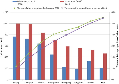
As shown in , in the twenty-first century, more than half of the world’s population live in urban areas, and the trend is constantly accelerating (Brenner and Schmid Citation2013; Cohen Citation2006; Osorio and Özkazanç-Pan Citation2014). Every year more than 60 million people, (an average of more than one million people per week) will crowd into the city (Mcgranahan and Satterthwaite Citation2014). Asia is one of the most dynamic economic regions in the world (Esterline, Wurfel, and Burton Citation2011). It is the first continent in terms of population and one of the most highly urbanized areas in the twenty-first century. According to United Nations Statistics, of the 358 cities with more than one million people in the world, 153 cities are located in Asia. Of the 27 super cities with more than 10 million people in the world, 15 cities are located in Asia (United Nations Citation2007). It was shown that in 2015 there are eight provincial capital cities in China with more than 400 km2 of urban area (). From 2000 to 2015, the proportion of urban areas in these eight cities has increased dramatically. The top eight cities were Beijing, Shanghai, Tianjin, Guangzhou, Chongqing, Hangzhou, Wuhan and Xi'an. The urban areas of these eight cities accounted for 54.8% of the total urban area of all provincial capital cities in China in 2015.
Figure 1. The development and growth of urbanization in the world from 1950 to 2030. Source: The data are taken from the website: http://www.un.org/en/databases/.
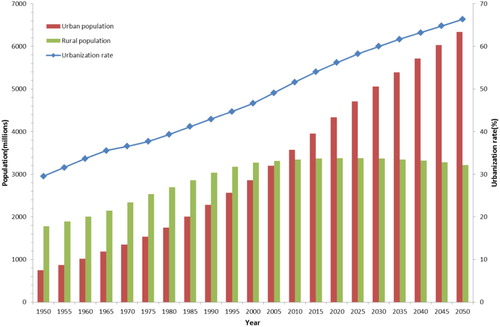
Figure 2. The urban area and the cumulative proportion of urban areas in 2000 and 2015 (the biggest eight cities sorted by urban area in China in 2015).
As a result of a series of reforms and opening-up policies, the process of urbanization in China has developed at an unprecedented pace (Chen et al. Citation2014a; Li et al. Citation2016; Liu et al. Citation2013; Liu et al. Citation2014). In 2011, the urban population of China has been more than half of the total population of China (United Nations Citation2012). Urban architecture is an important aspect of the urbanization process, and the area of construction sites in China has increased by 20 times compared to 1958. Because cities have concentrated most of the achievements and resources of human social development, the urbanization process has benefited more of the general public. However, with the rapid expansion of the cities and the increase in urban population, this has also produced several new urban problems, such as unusually fragile infrastructure, increasing traffic congestion, deteriorating ecological environment, living conditions of migrant workers, fierce competition for limited quality resources and also the rising urban crime rate (Batty Citation2008; Fuchs et al. Citation1994; Mills and Mitra Citation1997; Rutkin Citation2014).
In 2012, Jackson and Simpson edited a book entitled: ‘D_CITY: Digital Earth; Virtual Nations: Data Cities’, published by the Group on Earth Observation (GEO Citation2005) (Jackson and Simpson Citation2012). See dcitynetwork.net/manifesto. Megacities have benefited greatly by many new Digital Earth technologies, enabling the visualization of large cities by means of Earth observation (Anderson et al. Citation2017), 3-D modelling (Stoter et al. Citation2013), image and data fusion (Pohl and van Genderen Citation2014), Big Data (Shu Citation2016), and mobile technology (Ellul and Altenbuchner Citation2014). This has enabled ‘Digital Cities’ or ‘Smart Cities’ strategies to develop in many countries around the world (Li et al. Citation2013). Many cities already proposed the construction content of future (smart) cities. For example, in 2017, Hong Kong proposed its smart city blueprint to increase competitiveness and urban vitality. The main goal was to make use of innovation and technology (I&T Citation2017) to address urban challenges, enhance the effectiveness of city management and improve people’s quality of living, as well as maximize Hong Kong’s sustainability, efficiency and safety; enhance Hong Kong’s attractiveness to global businesses and talents; and inspire continuous city innovation and sustainable economic development.
The Global Earth Observation System of Systems (GEOSS) was built by various countries and proposed two implementation plans to support sustainable development with foci such as understanding environmental factors that affect human health and well-being, improved management of energy resources, improving water resource management etc. Digital City could be considered as a scientific urban manifestation of a Digital Earth. Additionally, many Smart City frameworks have been put forward by commercial vendors to promote the concept of cities with sentient infrastructure. However, these frameworks can only be called Intelligent City frameworks, as there has not yet been a real improvement on the quality of urban life after the Internet of Things sensors are adopted.
The smart city should be a sustainable city. As the forum for the future analysis, there are five types of sustainable capital from where we derive the goods and services we need to improve the quality of our lives. These are: Natural Capital, Human Capital, Social Capital, Manufactured Capital and Financial Capital. This ‘Five Capitals’ model can help us have a better understanding of the Smart City. In the following sections we first examine some of the unique and key problems faced by megacities (Section 2). Then we discuss the approaches used by several megacities in Western developed countries (Section 3) before presenting suggestions for the construction of a major new megacity in China (Section 4). The paper ends with some conclusions and recommendations for constructing megacities in China.
2. The main challenges for sustainable development of megacities
The economies and societies of megacities have developed rapidly, but they are also under pressure from increasing population, resources, and ecological threats (Andrade et al. Citation2017; Ao et al. Citation2016; Han et al. Citation2014; Ramachandra, Bharath, and Sowmyashree Citation2015). Indeed, as argued by Laurini in a recent book, geographic knowledge engineering is needed for city or territory infrastructure. Multidisciplinary knowledge and citizen involvement allows not only spatial reasoning but also evaluation of various scenarios and alternatives for territorial intelligence governance, to help face the main problems of megacities (Laurini Citation2017).
In urban central districts, high-density architecture and the reduction of green coverage have seriously deteriorated the urban environment and at times, have caused an urban ecological imbalance (Su et al. Citation2016). Dense populations and industrial pollution have seriously damaged urban ecological environments, as shown by Chan and Yao and many others (Chan and Yao Citation2008; Hong et al. Citation2015; Su et al. Citation2016), causing some problems such as environmental pollution (Chen, Chen, and Fath Citation2014b), heat island effect (Zhou et al. Citation2016), urban waterlogging (Quan et al. Citation2010) etc. The problem of urban traffic has a direct impact on social and economic development and on the normal lives of residents. With continuous expansion, resistance to various types of disasters has been weakened for several cities. Problems of coexistence of mansions and slums, tight living spaces, poor living conditions, employment difficulties and so on, stimulate urban crime. Waste disposal also is a serious issue in many large cities, with a lack of appropriate waste disposal sites where needed.
This paper analyses the following four outstanding problems from the perspective of urban geography and ecology.
The problems of land subsidence in megacities.
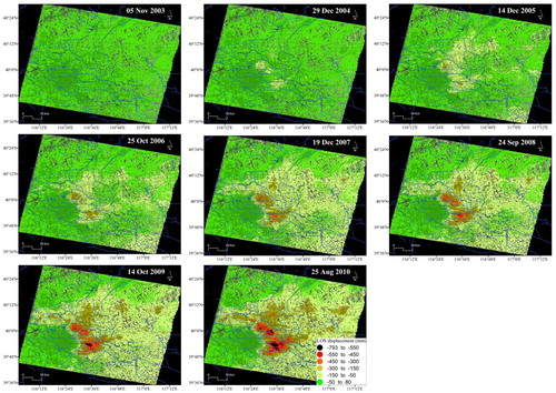
Land subsidence is a serious natural disaster, which can endanger the security of urban infrastructure. At present, more than 150 major cities face the threat of land subsidence (Hu et al. Citation2004; Tomás et al. Citation2010), and there are more than 50 cities in China where land subsidence has occurred (Deng et al. Citation2017). Due to the over-exploitation of groundwater (Chaussard et al. Citation2014; Zhu et al. Citation2015), Beijing, a large city, has been plagued by land subsidence for many years (Deng et al. Citation2017). shows the temporal and spatial evolution of land subsidence in Beijing from 2003 to 2010, and it can be seen that the ground subsidence is increasing year by year. This study used ENVISAT ASAR images obtained from 2003 to 2010. An analysis of these results showed that pumping groundwater frequently affects the surface structure and geological deformation, and subsequently results in land subsidence.
(b) Environmental problems in megacities.
Figure 3. Temporal and spatial evolution process of accumulated land subsidence in Beijing. Source: adapted from Deng et al. (Citation2017).
The most typical environmental problems in large cities are environmental pollution and urban heat island effects (Livesley, McPherson, and Calfapietra Citation2016), including urban microclimate, urban waste, urban air quality, haze, carbon emissions and heat discomfort. For example, Beijing has dust storms and Wuhan has summer waterlogging.
Traditional urban construction patterns require building, pavement and parking lots with impervious surfaces. Drainage depends on the canal/pumping stations, which take ‘quick elimination’ and ‘end concentration’ (Butler and Davies Citation2003; Miguez et al. Citation2012; Wang Citation2016) as their main strategies. Thus, urban waterlogging occurs when it rains. In 2010, according to Chinese Government statistics, 62% of 351 cities in China had different levels of urban waterlogging, and 137 cities experienced three times or more waterlogging within a year. Researchers have proposed the ‘sponge city’ concept to resolve these issues (Bunster-Ossa Citation2013). Impervious surface areas, such as hard pavements and building roofs, are expanding in most cities (Kuang et al. Citation2013; Su, Yang, and Chen Citation2012).
When the urban impervious surface accounts for more than 75% of the urban area, more than half of the precipitation needs to be discharged by surface runoff, and the change of impervious surfaces fundamentally changes the precipitation redistribution. Water cycles change according to impervious surface dynamics, explaining why there are so many waterlogging issues. Impervious surface changes radically alter rainfall redistribution, and the magnitude and spatial patterns of impervious surfaces impact the groundwater recharge, runoff and discharge conditions.
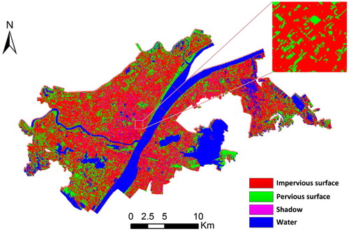
As shown in , in the building-intensive area of the city centre, the impervious surface is up to 78.75% of the urban area, vegetation is only 4.44%, and water bodies cover only 0.61%. The impervious surface rate of the core city has exceeded 75%, so the city loses the capacity for flood control and fails to cope with the waterlogging caused by a 24 hour rainstorm. However, most foreign cities pay attention to this issue, and adequate green space exists in the middle of many Western cities, so that they have good permeability.
Figure 4. Impervious surface distribution of Wuhan city based on ZY-3 images.
Now China’s government is promoting the sponge city national strategy of urban planning to solve this major issue of urban flooding. There are three key issues with sponge city planning, including the resilient city, low-impact development and sustainable resource management.
(c) Traffic problems in megacities.
During peak hours of commuting, a megacity has some problems, such as traffic congestion, difficulty in parking, difficulty in traveling of the public transport and in traffic management (Chen and Song Citation2014). Intelligent transportation cannot be completely solved solely by technical means such as sensor networks. Therefore, the system theory and the system engineering theory proposed by Tsien Hsueshen (Li Citation2011) should be applied to solve traffic challenges and problems. Traffic congestion can also lead to a series of problems, such as economic loss, energy waste, air pollution and noise pollution, etc. (Weisbrod, Vary, and Treyz Citation2003).
The United States has similar problems. Traffic congestion in the US lost 87.2 billion dollars and wasted 2.8 billion gallons of gasoline and 4.2 billion hours in 2007 (Mathur et al. Citation2010; Parsons Citation2009). A 2011 report from the Chinese Academy of Sciences shows that residents of 15 Chinese cities spent more than 57.6 billion minutes on the way to work every day, more than the residents of European cities, and the loss is 20 billion Yuan (Niu Citation2012). At the same time, the exhaust gas from vehicles is one of the main sources of urban air pollution (Colvile et al. Citation2001), resulting in haze, PM2.5 and so on.
(d) Energy problems in megacities.
Energy systems in big cities also have many problems. Energy production is unsustainable and energy consumption is inefficient. Off-peak supply and other intelligent energy allocation strategies should be employed to solve the intelligent scheduling and load problems on the ground.
The energy consumption of megacities is large (Carmichael, Adhikary, and Mena Citation2007), and the problem of green energy needs to be solved (Carver Citation2012; Kammen and Sunter Citation2016). The Obama administration in the United States made it a priority to put solar cells on the roofs of houses to provide renewable energy. In China, the cities of the Lhasa–Lanzhou–Taiyuan–Beijing–Tianjin–Dalian can install solar panels for power generation at the top and sunny side of a building. Street lighting systems, using solar energy and wind energy, have been popularized in many parts of China (Liu and Wang Citation2009; Shi et al. Citation2012).
However, the current extent of solar power generation in China is still rare (Peidong et al. Citation2009), so it is necessary to study how to make full use of solar energy in areas with plenty of solar energy for supplying pollution-free energy, the car's orderly power supply, urban management and so on. Few measures are available now to address these problems. Smart city emergency management can exploit the full value of big data (Yang, Su, and Chen Citation2017).
3. Development of megacities in western developed countries
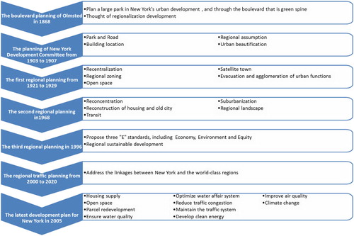
Megacities in western developed countries have had detailed planning strategies for many years, and the evolution of the planning strategy in different stages can provide useful reference for the development of super-large cities in China. For example, New York City has successively launched many city plans, and the trend is from city planning to regional planning, to the construction of satellite towns, and ultimately to the formation of a regional sustainable city rather than a simple expansion like the ‘pie’ (G. L. Citation1932). shows the evolution route of the planning strategy at different stages in New York City, which can show the development process through satellite imagery of different ages (Kowsky Citation1987). A series of scientific plans can ensure balanced, wholistic development of the entire region.
Figure 5. The evolution of New York planning strategy at different stages. Source: adapted from Tian (Citation2010).
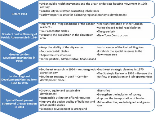
is the roadmap of London’s planning strategy at different stages. London, like New York, emphasises regional development through the planning and construction of satellite cities.
Figure 6. The evolution of London planning strategy at different stages. Source: adapted from Tian (Citation2010).
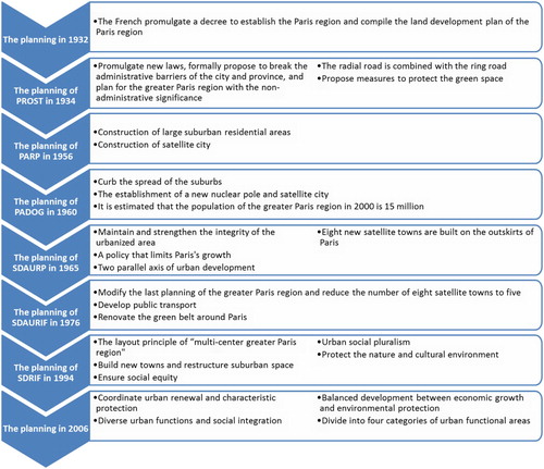
shows the roadmap of Paris planning strategy at different stages. Paris has a similar trend, using the planning of satellite cities and functional areas to produce coordinated city development.
Figure 7. The evolution of Paris planning strategy at different stages. Source: adapted from Tian (Citation2010).
4. Suggestions for planning and construction of a new megacity in China
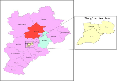
In view of a series of problems exposed by big cities, scientific planning and governance is needed the future development of cities in China. For example, planning and construction of the Xiong’an New Area needs to focus on the positioning of Beijing's non-capital functions and coordinate development with the overall planning of Beijing. One must unify the systematic planning to form a new urban agglomeration of the Beijing-Tianjin-Hebei region. As shown in , the Beijing–Tianjin–Hebei Urban Agglomeration located in the heart of the Bohai Sea in Northeast Asia, with an area of 218,000 square kilometres and 110 million residents, is the largest and most dynamic region in the north of China. It consists of 13 cities, including Beijing, Tianjin, Shijiazhuang, Zhangjiakou, Qinhuangdao, Tangshan, Baoding, Langfang, Xingtai, Handan, Hengshui, Cangzhou and Chengde. The following strategies are proposed for this region.
Scientific planning considering urban geology
Figure 8. Locations of the Beijing–Tianjin–Hebei Urban Agglomeration and Xiong’an New Area.
Taking into account the geological conditions of the city, scientific planning should be carried out. To master the distribution of the geological and fracture zones, the underground structure should be explored, both for seismic hazard assessment and for underground construction of metro systems and other underground infrastructure. Site selections for subways and high-rise buildings must be scientific and accurate.
(b) Reasonable control of the size of urban population
Urban population is a comprehensive indicator of a city’s carrying capacity. It is necessary to plan a harmonious and sustainable ecological environment for reasonable control of population size and population composition. Regular monitoring of a city’s growth and development should be made using Earth observation and other geospatial technologies, so that any corrective measures that may be needed during the growth of a new megacity can be implemented efficiently. This should be strategized at the very beginning, to serve as a baseline from which each subsequent phase of the megacity’s development can be accurately monitored, and the plans adapted or modified if necessary.
(c) Reasonable layout of the industry and construction of satellite cities.
Each city should have a reasonable layout for its industry. Construction of satellite towns in a megacity is not a simple expansion. For example, current planning of the Xiong’an New Area will be positioned as a concentrated urban area with non-capital functions, which will remain located in Beijing. The Xiong’an New Area can develop a commercial aerospace industry, which is an emerging industry that is very dynamic all over the world and has a great potential for China and the world in the future. The Xiong’an New Area needs to attract similar high technology industries.
(d) Protection and scientific planning of urban water resources
Water resources are necessary for the sustainable development of a city and need to be protected and scientifically planned. For example, it is suggested that the development of the Xiong’an New Area can be integrated with the South-to-North Water Diversion project (Office of the South-to-North Water Diversion Project Construction Committee Citation2016), because the water in Baiyangdian Lake will not be sufficient for this new megacity. Perhaps diversion of water from the Yangtze River will support development of the Xiong’an New Area. When the amount of water is low or drought occurs, extra supply can come from the South-to-North Water Diversion, and abundant water can be transported to Beijing and Tianjin. This can also ensure water quality through water source protection, including less fertilization and less pollution by civilians who live in the reservoir area.
(e) The development of half an hour convenient high-speed traffic.
Megacities cannot take a simple approach of expanding like a pie, it will only make the traffic become more congested. Between the megacity centre and the satellite city, it is necessary to consider developing convenient transportation (half an hour door to door). For example, there should be a half-hour traffic circle between Beijing and Tianjin. Specifically, between the Xiong’an New Area and Beijing and Tianjin, there should be a convenient and fast subway or high-speed rail to achieve an effective public transport network. Scientific traffic planning will ensure overall coordinated development in the megacity.
(f) Pay attention to the protection of the environment, to try to use green energy
New megacities will, in time, become historic and cultural heritage areas through continuous improvement of planning to stay up to date over time. They should draw lessons from the planning processes of foreign megacities, to help the megacity or the Xiong’an New Area become an environmentally friendly and green new town.
(g) Matching resources to allow residents to peacefully live and work.
Residents of downtowns and satellite cities can live and work in peace through the matching and optimization of resources in both areas. The example is the annual migration of thousands of residents from north east China’s Heilongjiang province, from cities such as Harbin, who travel to Sanya on tropical Hainan island to escape the winter cold for the winter months. They return north for the summer months. When they arrive in Hainan, there is a shortage of resources, and pressure on the environment, but after they leave, the temporary facilities lie idle, and resources are wasted.
(h) To strengthen the rational development and utilization of underground and semi-underground spaces in megacity
New megacities in China face the bottlenecks of development because of limited land. However, technology for optimum use of the underground and semi-underground space engineering is accelerating. Moreover, planning and construction of subways and underground car parks are also the main sources of urban geological disasters. To facilitate better surface ecology and sponge city solutions, underground and semi-underground spaces should be rationally developed and utilized, using sound engineering geology and geospatial technology.
(i) To build a smart sustainable city.
This future megacity will have attributes including sustainability, high quality of life, and a good economic and social environment.
5. Conclusions
Throughout human history, the city has played an important role in the major changes and transformations of various historical periods. Against today’s background of global urbanization, it is necessary to coordinate deep-seated problems such as the utilization of land economy, sustainable development of the city, protection of historical and cultural heritage, resilience of human settlements to resist various disasters, and maintenance of good planning. The smart city has broad prospects for economic restructuring and development, urban management and intelligent services to the public; ensuring more coordinated development between people and nature. The historic strategic deployment of the Xiong’an New Area, representing the ‘Millennium Plan, National Events’ policy, will play an important role in the current reform and transformation of the big city. With the goal of ‘world vision, international standards, Chinese characteristics, high goals’ (Xiongan Citation2018), urban planners and builders should fully solicit the wisest proposals to promote China's megacity planning and construction. It can use these advantages to boost the realization of the Chinese Dream.
Disclosure statement
No potential conflict of interest was reported by the authors.
Additional information
Funding
References
- Anderson, K., B. Ryan, W. Sonntag, A. Kavvada, and L. Friedl. 2017. "Earth Observation in Service of the 2030 Agenda for Sustainable Development." Geo-spatial Information Science 20 (2): 77–96. doi:10.1080/10095020.2017.1333230.
- Andrade, M. D. F., P. Kumar, E. D. de Freitas, R. Y. Ynoue, J. Martins, L. D. Martins, T. Nogueira, et al. 2017. “Air Quality in the Megacity of São Paulo: Evolution Over the Last 30 Years and Future Perspectives.” Atmospheric Environment 159: 66–82. doi: 10.1016/j.atmosenv.2017.03.051
- Ao, X., C. S. B. Grimmond, Y. Chang, D. Liu, Y. Tang, P. Hu, Y. Wang, J. Zou, and J. Tan. 2016. "Heat, Water and Carbon Exchanges in the Tall Megacity of Shanghai: Challenges and Results." International Journal of Climatology 36 (14): 4608–4624. doi:10.1002/joc.4657.
- Batty, M. 2008. “The Size, Scale, and Shape of Cities.” Science 319 (5864): 769. doi: 10.1126/science.1151419
- Brenner, N., and C. Schmid. 2013. "The ‘Urban Age’ in Question." International Journal of Urban and Regional Research 38 (3): 731–755. doi:10.1111/1468-2427.12115.
- Bunster-Ossa, I. F. 2013. “Sponge City.” In Resilience in Ecology and Urban Design: Linking Theory and Practice for Sustainable Cities, edited by S. T. A. Pickett, M. L. Cadenasso, and B. McGrath, 301–306. Dordrecht, Netherlands: Springer.
- Butler, D., and J. Davies. 2003. Urban Drainage. Boca Raton, FL: CRC Press.
- Carmichael, G., B. Adhikary, and M. Mena. 2007. "Regional and Global Perspective of Megacity Air Pollution. The Place of theMediterranean in Modern Israeli Identity." Brill 2014: 184–190.
- Carver, J. 2012. “Megacity China.” New Scientist 216 (2895): 30–31. doi: 10.1016/S0262-4079(12)63186-8
- Chan, C. K., and X. Yao. 2008. “Air Pollution in Mega Cities in China.” Atmospheric Environment 42 (1): 1–42. doi: 10.1016/j.atmosenv.2007.09.003
- Chaussard, E., S. Wdowinski, E. Cabral-Cano, and F. Amelung. 2014. "Land Subsidence in Central Mexico Detected by ALOS InSAR Time-Series." Remote Sensing of Environment 140: 94–106. doi:10.1016/j.rse.2013.08.038.
- Chen, S., B. Chen, and B. D. Fath. 2014b. “Urban Ecosystem Modeling and Global Change: Potential for Rational Urban Management and Emissions Mitigation.” Environmental Pollution 190: 139–149. doi: 10.1016/j.envpol.2014.03.032
- Chen, M., Y. Huang, Z. Tang, D. Lu, H. Liu, and L. Ma. 2014a. "The Provincial Pattern of the Relationship Between Urbanization and Economic Development in China." Journal of Geographical Sciences 24 (1): 33–45. doi:10.1007/s11442-014-1071-9.
- Chen, J., and Y. Song. 2014. Research on Traffic Problems and Solving Strategies of Polyclinics in the City of Shenzhen. New York: Transportation Science & Technology.
- Cohen, B. 2006. “Urbanization in Developing Countries: Current Trends, Future Projections, and key Challenges for Sustainability.” Technology in Society 28 (1): 63–80. doi: 10.1016/j.techsoc.2005.10.005
- Colvile, R. N., E. J. Hutchinson, J. S. Mindell, and R. F. Warren. 2001. "The Transport Sector as a Source of air Pollution." Atmospheric Environment 35 (9): 1537–1565. doi:10.1016/S1352-2310(00)00551-3.
- Deng, Z., Y. Ke, H. Gong, X. Li, and Z. Li. 2017. "Land Subsidence Prediction in Beijing Based on PS-InSAR Technique and Improved Grey-Markov Model." GIScience & Remote Sensing 54 (6): 797–818. doi:10.1080/15481603.2017.1331511.
- De Rynck, F., L. Boudry, A. Loeckx, E. Corijn, P. Cabus, and C. Kesteloot. 2005. “The Century of the City, City Republics and Grid Cities.” Ministerie Van De Vlaamse Gemeenschap Brussel 467 (6): 1–238.
- Ellul, C., and J. Altenbuchner. 2014. “Investigating Approaches to Improving Rendering Performance of 3D City Models on Mobile Devices.” Geo-Spatial Information Science 17 (2): 73–84. doi: 10.1080/10095020.2013.866620
- Esterline, M. H., D. Wurfel, and B. Burton. 2011. “Southeast Asia in the New World Order: The Political Economy of a Dynamic Region.” Journal of Southeast Asian Studies 56 (1): 179–180.
- The Five Capitals. https://www.forumforthefuture.org/project/five-capitals/overview.
- Fuchs, R. J., E. Brennan, J. Chamie, F. Lo, and J. I. Uitto. 1994. Mega-City Growth and the Future. Tokyo: United Nations University Press.
- G. L., P. 1932. “Regional Plan of New York and Its Environs.” The Town Planning Review 15 (2): 123–136. doi: 10.3828/tpr.15.2.t86268432t752030
- Group on Earth Observations. 2005. The Global Earth Observation System of Systems (GEOSS) 10-Year Implementation Plan. Noordwijk: ESA Publications Division.
- Han, T., X. Liu, Y. Zhang, J. Gu, H. Tian, L. Zeng, S.-Y. Chang, Y. Cheng, K. Lu, and M. Hu. 2014. "Chemical Characteristics of PM10 During the Summer in the Mega-City Guangzhou, China." Atmospheric Research 137: 25–34. doi:10.1016/j.atmosres.2013.10.004.
- Hong, Y., H. E. Sha, Z. Ting, W. Fei, and W. Tieming. 2015. "Review of Researches on the Protection of Urban Plant Diversity." Journal of Landscape Research 7 (1): 39–40.
- Hu, R. L., Z. Q. Yue, L. C. Wang, and S. J. Wang. 2004. "Review on Current Status and Challenging Issues of Land Subsidence in China." Engineering Geology 76 (1): 65–77.
- Innovation and Technology Bureau. 2017. Hong Kong Smart City Blueprint. Hong Kong. 2017,12.
- Jackson, D., and R. Simpson. 2012. D_City: Digital Earth, Virtual Nations, Data Cities. Sydney: GEO/DCity.
- Kammen, D. M., and D. A. Sunter. 2016. "City-Integrated Renewable Energy for Urban Sustainability." Science 352 (6288): 922–928. doi:10.1126/science.aad9302.
- Kowsky, F. R. 1987. "Municipal Parks and City Planning: Frederick Law Olmsted's Buffalo Park and Parkway System." Journal of the Society of Architectural Historians 46 (1): 49–64. doi:10.2307/990145.
- Kuang, W. H., J. Y. Liu, Z. X., Zhang, D. S. Lu, and B. Xiang. 2013. “Spatiotemporal Dynamics of Impervious Surface Areas Across China During the Early 21st Century.” Chinese Science Bulletin 58 (14): 1691–1701. doi: 10.1007/s11434-012-5568-2
- Laurini, R. 2017. Applications to Territorial Intelligence and Smart Cities. Paris: ISTE-Elsevier.
- Li, P. 2011. Collected Works of Hsue-Shen Tsien. Shanghai: Shanghai Jiao Tong Unive.
- Li, D., J. Shan, Z. Shao, X. Zhou, and Y. Yao. 2013. “Geomatics for Smart Cities - Concept, Key Techniques, and Applications.” Geo-Spatial Information Science 16 (1): 13–24. doi: 10.1080/10095020.2013.772803
- Li, M., Z. Zhang, D. Lo Seen, J. Sun, and X. Zhao. 2016. "Spatiotemporal Characteristics of Urban Sprawl in Chinese Port Cities From 1979 to 2013." Sustainability 8 (11): 1138–1138.
- Liu, L.-Q., and Z.-X. Wang. 2009. “The Development and Application Practice of Wind-Solar Energy Hybrid Generation Systems in China.” Renewable and Sustainable Energy Reviews 13 (6): 1504–1512. doi: 10.1016/j.rser.2008.09.021
- Liu, Z., Y. Wang, Z. Li, and J. Peng. 2013. “Impervious Surface Impact on Water Quality in the Process of Rapid Urbanization in Shenzhen, China.” Environmental Earth Sciences 68 (8): 2365–2373. doi: 10.1007/s12665-012-1918-2
- Liu Q., Y. Yang, H. Tian, B. Zhang, and L. Gu. 2014. “Assessment of Human Impacts on Vegetation in Built-up Areas in China Based on AVHRR, MODIS and DMSP_OLS Nighttime Light Data, 1992–2010.” Chinese Geographical Science 24 (2): 231–244. doi: 10.1007/s11769-013-0645-2
- Livesley, S., E. McPherson, and C. Calfapietra. 2016. “The Urban Forest and Ecosystem Services: Impacts on Urban Water, Heat, and Pollution Cycles at the Tree, Street, and City Scale.” Journal of Environment Quality 45 (1): 119–124. doi: 10.2134/jeq2015.11.0567
- Mathur, S., T. Jin, N. Kasturirangan, J. Chandrashekharan, W. Xue, M. Gruteser, and W. Trappe. 2010. “ParkNet: Drive-by Sensing of Road-Side Parking Statistics.” Proceedings of the 8th international conference on Mobile systems, applications, and services, San Francisco, CA, ACM, 123–136.
- Mcgranahan, G. and Satterthwaite, D. 2014. “Urbanisation Concepts and Trends.” Haemophilia 20 (6): e402–e404. doi: 10.1111/hae.12491
- Miguez, M. G., J. M. Bahiense, O. M. Rezende, and A. P. Veról. 2012. “New Urban Developments: Flood Control and LID – A Sustainable Approach for Urban Drainage Systems.” WIT Transactions on Ecology and the Environment 155: 469–480. doi: 10.2495/SC120391
- Mills, E. S., and A. Mitra. 1997. Urban Development and Urban Ills. New Delhi: Commonwealth Publishers.
- Nature. 2010. “Cities: The Century of the City.” Nature 467 (7318): 900–901. doi: 10.1038/467900a
- Niu, W. 2012. China's New-Urbanization Report 2012. Beijing: Science Press.
- Office of the South-to-North Water Diversion Project Construction Committee, S. C., PRC. 2016. “The South-to-North Water Diversion Project.” Engineering 2 (3): 265–267. doi: 10.1016/J.ENG.2016.03.022
- Osorio, A. E., and B. Özkazanç-Pan. 2014. "Defining the ‘Urban’ in Urban Entrepreneurship: Implications for Economic Development Policy." Academy of Management Proceedings 2014 (1): 12486–12486. doi:10.5465/ambpp.2014.12486abstract.
- Parsons, G. F. 2009. “The Parallel Flow Intersection: A New High Capacity Urban Intersection.” IET Conference Proceedings [online]. http://digital-library.theiet.org/content/conferences/10.1049/cp.2009.1603.
- Peidong, Z., Y. Yanli, S. Jin, Z. Yonghong, W. Lisheng, and L. Xinrong. 2009. “Opportunities and Challenges for Renewable Energy Policy in China.” Renewable and Sustainable Energy Reviews 13 (2): 439–449. doi: 10.1016/j.rser.2007.11.005
- Pohl, C., and J. van Genderen. 2014. “Remote Sensing Image Fusion: An Update in the Context of Digital Earth.” International Journal of Digital Earth 7 (2): 158–172. doi: 10.1080/17538947.2013.869266
- Quan, R.-S., M. Liu, M. Lu, L.-J. Zhang, J.-J. Wang, and S.-Y. Xu. 2010. “Waterlogging Risk Assessment Based on Land use/Cover Change: A Case Study in Pudong New Area, Shanghai.” Environmental Earth Sciences 61 (6): 1113–1121. doi: 10.1007/s12665-009-0431-8
- Ramachandra, T. V., A. H. Bharath, and M. V. Sowmyashree. 2015. “Monitoring Urbanization and its Implications in a Mega City From Space: Spatiotemporal Patterns and its Indicators.” Journal of Environmental Management 148: 67–81. doi: 10.1016/j.jenvman.2014.02.015
- Rutkin, A. 2014. “How Data can Save a City.” New Scientist 224 (2990): 24–25. doi: 10.1016/S0262-4079(14)61945-X
- Shi, J., T. Chen, J. Meng and H. Lin. 2012. “Stable Wind-Solar Energy Hybrid Generation System for Road Lighting.” Journal of Tsinghua University Science and Technology 52 (2): 139–143.
- Shu, H. 2016. “Big Data Analytics: Six Techniques.” Geo-Spatial Information Science 19 (2): 119–128. doi: 10.1080/10095020.2016.1182307
- Stoter, J., L. van den Brink, J. Beetz, H. Ledoux, M. Reuvers, P. Janssen, F. Penninga, G. Vosselman, and S. Oude Elberink. 2013. “Three-dimensional Modeling with National Coverage: Case of The Netherlands.” Geo-Spatial Information Science 16 (4): 267–276. doi: 10.1080/10095020.2013.866619
- Su, Y., X. Chen, J. Liao, H. Zhang, C. Wang, Y. Ye, and Y. Wang. 2016. “Modeling the Optimal Ecological Security Pattern for Guiding the Urban Constructed Land Expansions.” Urban Forestry & Urban Greening 19: 35–46. doi: 10.1016/j.ufug.2016.06.013
- Su, W., G. Yang, and S. Chen. 2012. “The Impact of Urban Spatial Expansion on Regional Environment of Flood Hazards Gestation: A Case Study in Jiangning District of Nanjing City.” Resource Science 34: 934–940.
- Tian, L., K. Yao, W. Wang, and H. Dong. 2010. A Comparative Study on City Planning, Construction and Development of World Cities. (In Chinese). Beijing: China Architecture & Building Press.
- Tomás, R., G. Herrera, J. Delgado, J. M. Lopez-Sanchez, J. J. Mallorquí, and J. Mulas. 2010. “A Ground Subsidence Study Based on DInSAR Data: Calibration of Soil Parameters and Subsidence Prediction in Murcia City (Spain).” Engineering Geology 111 (1): 19–30. doi: 10.1016/j.enggeo.2009.11.004
- United Nations. 2007. “Population of Capital Cities and Cities of 100 000 and more Inhabitants: Latest Available Year 1986–2007.” https://unstats.un.org/unsd/demographic/products/dyb/dyb2007/Table08.pdf.
- United Nations. 2012. “Total and Urban Population by Sex: 2003-2012.” https://unstats.un.org/unsd/demographic/products/dyb/dyb2012/Table06.pdf.
- Urbanization, U. C. 2016a. “Evolution, Status, and Reform of Hukou.” Understanding Chinas Urbanization.
- Urbanization, U. C. 2016b. “Towns and Rural Urbanization.” Understanding Chinas Urbanization.
- Wang, X. 2016. “The Cause for Storm Water Logging in Luoyang and Countermeasure.” Journal of Residuals Science & Technology 13 (6).
- Weisbrod, G., D. Vary, and G. Treyz. 2003. “Measuring Economic Costs of Urban Traffic Congestion to Business.” Transportation Research Record: Journal of the Transportation Research Board 1839: 98–106. doi: 10.3141/1839-10
- Xiongan. 2018. http://english.xiongan.gov.cn/.
- Yang, C., G. Su, and J. Chen. 2017. “Using Big Data to Enhance Crisis Response and Disaster Resilience for a Smart City.” ed. 2017 IEEE 2nd International Conference on Big Data Analysis (ICBDA), March 10–12, 504–507.
- Zhou, D., L. Zhang, L. Hao, G. Sun, Y. Liu, and C. Zhu. 2016. “Spatiotemporal Trends of Urban Heat Island Effect Along the Urban Development Intensity Gradient in China.” Science of The Total Environment 544: 617–626. doi: 10.1016/j.scitotenv.2015.11.168
- Zhu, L., H. Gong, X. Li, R. Wang, B. Chen, Z. Dai, and P. Teatini. 2015. “Land Subsidence due to Groundwater Withdrawal in the Northern Beijing Plain, China.” Engineering Geology 193: 243–255. doi: 10.1016/j.enggeo.2015.04.020