
ABSTRACT
When defining indicators on the environment, the use of existing initiatives should be a priority rather than redefining indicators each time. From an Information, Communication and Technology perspective, data interoperability and standardization are critical to improve data access and exchange as promoted by the Group on Earth Observations. GEOEssential is following an end-user driven approach by defining Essential Variables (EVs), as an intermediate value between environmental policy indicators and their appropriate data sources. From international to local scales, environmental policies and indicators are increasingly percolating down from the global to the local agendas. The scientific business processes for the generation of EVs and related indicators can be formalized in workflows specifying the necessary logical steps. To this aim, GEOEssential is developing a Virtual Laboratory the main objective of which is to instantiate conceptual workflows, which are stored in a dedicated knowledge base, generating executable workflows. To interpret and present the relevant outputs/results carried out by the different thematic workflows considered in GEOEssential (i.e. biodiversity, ecosystems, extractives, night light, and food-water-energy nexus), a Dashboard is built as a visual front-end. This is a valuable instrument to track progresses towards environmental policies.
1. Introduction
Sustainable development that preserves the capacity of the environment to sustain well-being of present and future generations can only be achieved through transformational pathways departing from the current unsustainable routes. Informed governance can lead to policies supporting best practices for sustainable development (Griggs et al. Citation2014; Griggs et al. Citation2013). Reaching the Sustainable Development Goals (SDGs), as adopted by the United Nations in 2015, should be constrained within stable and functioning life-support systems that define a safe operating space for humanity (Rockstrom et al. Citation2009; Steffen et al. Citation2015). Raworth (Citation2012) is further defining a safe and just space by integrating the social boundaries. This means addressing biophysical and social targets in ways that incorporate synergies and tradeoffs. Griggs (Griggs et al. Citation2014; Griggs et al. Citation2013) also recommends working with quantifiable targets at multiple geographical scales and across sectors. For now, the Inter-Agency Expert Group on SDG Indicators provided a first set of indicators for consideration by the United Nations Statistical Commission. The International Council for Science (ICSU Citation2015; Lu et al. Citation2015) has defined five priorities for science to measure progress towards the SDGs: (i) design a set of practical indices; (ii) set up a monitoring program for these indices; (iii) evaluate the performance towards achieving the targets; (iv) improve the observational infrastructures; and (v) standardize the sources and quality of data. An additional recommendation is that the SDGs indicators are aligned with those of existing international agreements (e.g. UNFCCC for climate, CBD Aichi targets for biodiversity (Brooks et al. Citation2015)).
Indeed, the temptation is great, when defining SDGs or other integrated environmental indicators, to reinvent the wheel instead of using existing initiatives and data available – for instance through the Group on Earth observations (GEO) and its Global Earth Observation System of Systems (GEOSS) (GEO Citation2017a). From an Information, Communication and Technology (ICT) perspective, data interoperability and standardization of web services are critical to improve data access and exchange. Other sources of information than remote sensing are based on the aggregation of national statistics, including the statistical agencies, or on efforts from other scientific communities and data mediators, for example the Global Biodiversity Information Facility (Wheeler Citation2004) in the biological domain. This example demonstrates the importance of ICT solutions and calls for data interoperability. Integrated environmental policies (e.g. SDG) should be linked conceptually, operationally and institutionally to the present efforts to better fill the existing gaps between science and policy (Lehmann et al. Citation2017b; Lehmann et al. Citation2014; Lehmann et al. Citation2015), and avoid unneeded confusion and redundancy.
In this context, Essential Variables (EVs) are used in Earth observation to identify variables that correspond to high impact on the Earth system and should be a priority for monitoring. EVs assume that there is a limited number of variables that are essential to characterize the state in a system without losing significant information on its past and future trends. The identification of these variables should help supporting adequate observing systems in the context of restricted budgets. EVs are also thought to improve the definition and maintenance of workflows from raw data to final end users’ products. Indeed, EVs are being used by different communities to define the smallest number of variables describing a system allowing to define indicators for policy purposes. The review of the set of EVs, conducted by ConnectinGEO (ConnectinGEO Citation2016b) in several GEO communities, revealed that there exist different maturity levels and a considerable overlap between the EVs identified by the different communities considered. The community working on the Global Climate Observing System (GCOS) was the first to develop a full set of EVs, i.e. the Essential Climate Variables (ECV) (Bojinski et al. Citation2014; Hollmann et al. Citation2013; Szczypta et al. Citation2014; Zeng et al. Citation2015; Miranda Espinosa, Giuliani, and Ray Citation2019). Presently, significant efforts are being made to define and monitor EVs in the areas of biodiversity and ecosystems (Pereira et al. Citation2013; Scholes et al. Citation2012), water (Lawford Citation2014), oceans (Constable et al. Citation2016; Hayes et al. Citation2015) and more recently on SDGs themselves (Reyers et al. Citation2017).
2. Research gaps and project objectives
With this shared interest on EVs, GEOEssential is going beyond sectoral approaches and identifies the cross-thematic EVs necessary for integrated approaches such as the Food-Water-Energy Nexus (Allouche, Middleton, and Gyawali Citation2014; Hoff Citation2011) and SDGs (see and ). New satellite sensors, data management capabilities, image analysis techniques, and free access to large and expanding data platforms (e.g. GEOSS and Copernicus Integrated Ground Segment) are greatly improving the opportunities to monitor environmental changes. Timely assessment of such changes is essential for good decision-making and effective management of natural resources.
Figure 1. GEOEssential project structure and work packages.
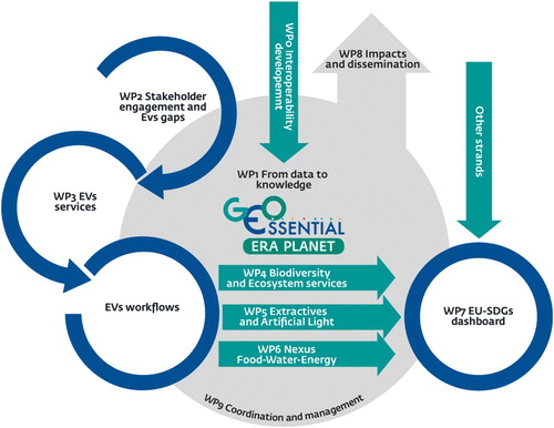
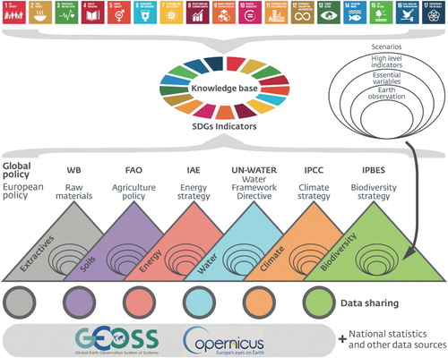
Figure 2. GEOEssential general framework linking data sources to policy indicators through Essential Variables with the help of a knowledge base.
The research gaps addressed by GEOEssential are described below:
ICT platform: effectively data sharing and use requires to improve the present infrastructural capacity to collect, aggregate, harmonize, analyze, and visualize large volume of heterogeneous data (including social and economic ones in addition to geospatial data) (Nativi, Craglia, and Pearlman Citation2013), making use of the services provided by the emerging Knowledge Base (KB) infrastructures (Nativi et al. Citation2019).
EVs definition: they have been reviewed in (ConnectinGEO Citation2016b) for many GEO Societal Benefit Areas (SBAs) such as Biodiversity, Climate, Water, and Ocean, but a clear demonstration of their implementations is missing, and their extensions to other SBAs can be improved. Furthermore, the identification of inherent cross-thematic EVs are still missing.
Indicators Processing: there are still large difficulties in harmonizing and in pulling together existing datasets to monitor or predict core indicators to answer policy needs at various spatial and temporal scales.
Trade-offs and synergies: Different areas of concerns of the environment are working in isolation; new governance (Sachs Citation2012; Waage et al. Citation2015) and frameworks such as Ecosystem Services and Natural Capital (Guerry et al. Citation2015; Ruckelshaus et al. Citation2015), Water-Energy-Food Nexus (Hoff Citation2011; Weitz, Nilsson, and Davis Citation2014; Fasel et al. Citation2016) or SDGs (Brandi Citation2015) are needed to identify synergies and trade-offs.
Visualization of complex datasets: Dashboards and story maps have emerged as good solutions to bring together and simplify large sets of indicators and to present them to stakeholders. Progress can still be made in Earth Observation to further improve these solutions.
Therefore, the main objectives of the project are to: (i) enhance the existing Knowledge Base infrastructure on EVs; (ii) address identified gaps in the definition and selection of EVs; (iii) improve the availability of EVs services from GEOSS and Copernicus platforms; (iv) assess the potential of synergies between ground and satellite observations; (v) develop specific data workflows and best practices to improve the interoperability; (vi) build the GEOEssential hub with a dashboard to navigate between data sources, EVs and policy indicators; and (vii) simplify and promote the use of EVs across the end users.
To address its research objectives, GEOEssential is organized in a series of work packages (WP), as depicted in . WP0 on Interoperability development is building the foundation of the project interoperability framework with its Key Enabling Technologies (KET) and the Knowledge Base infrastructure for Essential Variables. WP1 on Data sharing, Management and Knowledge is defining the data management strategy. WP2 continues the work of the ConnectinGEO project to engage with various stakeholders and update the list of existing EVs. WP3 is making available a maximum of GEOSS and Copernicus EV services. WP4, 5 and 6 are creating demonstration workflows from data sources to indicators through EVs for different environment policies. WP7 is bringing together the outputs of the previous actions to create a dashboard to of maps and indicators derived from EVs. WP8 is disseminating the outputs of the project to the identified stakeholders and end users.
Indeed, GEOEssential implements complete DATA > EVs > INDICATORS > POLICY workflows through the GEO infrastructure. Once established, this procedure will be ready to be replicated for any science-policy interface such as international, European and national policies by lifting the barriers from data to knowledge to address the sustainability challenge of maintaining or improving quality of life while staying within the planetary boundaries (Lehmann et al. Citation2017a; Lehmann et al. Citation2017b).
2.1. Nexus food-water-energy
In recent years, the Nexus approach has emerged as a key narrative to describe complex interlinkages between food, water, and energy cycles (Allouche, Middleton, and Gyawali Citation2014; Hoff Citation2011; Giampietro and Mayumi Citation2000; Giampietro and Bukkens Citation2015). Both from an analytical and normative viewpoint, the Nexus concept is helpful to go beyond trade-offs and the identification of winners and losers (Weitz, Nilsson, and Davis Citation2014). This approach aims at moving environmental, technical, human and financial resources management from silos to an implementation of integrated and cost-effective measures towards the identification of shared benefits along specific value chains such as electrical power production (Biggs et al. Citation2015).
Underlying the call to pursue a Nexus approach and the SDGs within the limits of planetary boundaries is the recognition that profound economic, societal and technical transformations are necessary. For example, much work remains to be done for economic indicators to reflect negative environmental externalities. The corresponding scientific challenges (Naeem et al. Citation2015) – gathering baseline data to document initial conditions, developing reliable metrics as indicators, observing essential variables, accounting for dynamic natural and human processes, incorporating trade-offs and synergies – are considerable and represent a central element of the Ecosystem Services (ES) framework.
2.2. Biodiversity and ecosystems
Biodiversity and ecosystems, their functions and services, assures the nature’s contribution to people and are key for human well-being. However, many species are threatened, several ecosystems are collapsing, and nature has entered a sixth phase of massive extinction. Data and indicators are needed to properly assess the changes and fill knowledge gaps. Harmonized efforts at all scales is underway to integrate various data sources. There is an urgent demand to further develop and use frameworks and concepts such as Essential Biodiversity Variables (Pereira et al. Citation2013) that help to evaluate long-term trends and change in species and ecosystems (Lausch et al. Citation2016; Skidmore et al. Citation2015). Hence, variables and indicators to analyze states and trends across time, space, communities and taxa will enable thorough assessments for the future. Specific workflows are therefore implemented in the project in order to assess the long-term change of biodiversity, e.g. of species distribution and richness, and the resilience of ecosystems and related use cases from local to global scale. Workflows are needed that include the mapping of the data landscape, the generation of Essential Variables and indicators and strategies for supporting international policy needs, such as for the Intergovernmental Platform for Biodiversity and Ecosystem Services (IPBES) and the UN Convention on Biological Diversity (CBD), but also the European Biodiversity Strategy. Actually, the ecosystem service concept implies a direct link between biodiversity and human well-being, and ecosystem services are currently considered as indicators for the SDGs and the CBD Aichi targets (Geijzendorffer et al. Citation2017; Geijzendorffer et al. Citation2016).
2.3. Extractive industry
As part of the abiotic natural capitals that we must also manage, the extractive sector -especially in fragile states – has great potential to support country development, but this potential might be hindered by lack of data availability and transparency. Being able to geographically integrate data layers from the extractive sector, as well as environmental and risk data, and to access this data from an online Spatial Data Infrastructure (SDI), can play a critical role by disseminating trusted and authoritative information. Initiatives like MapX (Lacroix et al. Citationin press) are insuring access to this data in a transparent way and can support reforms in selected countries on natural resources governance, promote equitable benefits sharing, enhance confidence in government and help support due diligence and risk identification for international investments to the extractives sector. In order to support a long-term and integrated vision and to not duplicate efforts it is critical to develop workflows that allow end users to monitor this information through time, to integrate the various phases of an extractive project and to integrate information of ongoing initiatives.
3. Policy needs and indicators
The GEOEssential project is built on an end-user driven approach to first identify environmental policy indicators, then their associated EVs, and finally the appropriate data sources. From international to local scales, environmental policies and indicators are more and more percolating from the global to the local agendas. Furthermore, integrative agendas such as the SDGs are built from thematic efforts and should reuse the work made in defining indicators in each domain (e.g. biodiversity and ecosystems, climate, water, energy, agriculture and extractives), as showed in .
3.1. At the global scale
3.1.1. Sustainable development goals (SDGs)
The SDGs are setting the scene for a more sustainable agenda for the world by 2030 with seventeen goals and 169 targets. Having been built from a large consultative effort they represent what the world of development estimates being the most important challenges to reach sustainability. A set of 232 indicators has been defined by the Inter-Agency and Expert Group on SDG Indicators (IAEG-SDGs) (UNSTAT Citation2018). These indicators are mostly thought to be derived from national statistics, but Earth observation could help in some instance where national statistics are lacking or when adequate statistics do not exist. Earth observation can also contribute to validate national statistics and provide assessment through time and space at finer resolutions. Earth observation could further help to define new indicators for environmental related targets where things could be more easily, rapidly and systematically monitored from space than from national statistics.
3.1.2. Convention on biological diversity (CBD) and the intergovernmental science-policy platform on biodiversity and ecosystem services (IPBES)
The CBD has been setting the scene for the national reporting on biodiversity conservation with the Aichi Targets since 1992. Decision XIII/28 of the Conference of the Parties to the CBD defined the indicators for the Strategic Plan for Biodiversity 2011–2020 and the Aichi Biodiversity Targets agreed in Nagoya in 2010. Established in 2010, the IPBES further developed a global and regional framework for biodiversity and ecosystem services models and scenarios, and further proposed a set of core and highlighted indicators to be used in its first assessment reports. In order to avoid duplication of efforts and dilution of messages, these policy instruments would gain in aligning their effort with the most closely related SDG goals, targets and indicators (i.e. SDG 14 and 15). This is indeed the case when we compare the list of IPBES indicators that are mostly derived from the CBD for monitoring the global biodiversity and ecosystem services governance. For further information see the IPBES Methodological Assessment on Scenarios and Models (IPBES Citation2016), the IPBES thematic assessment on land degradation (IPBES Citation2018), and series of IPBES regional Assessments.
3.1.3. United nations framework convention on climate change (UNFCCC), and the intergovernmental panel on climate change (IPCC)
The IPCC has defined several indicators for the AR5 report to follow climate change, and impact and adaptation possibilities (IPCC Citation2014). These indicators are usually integrated in a vulnerability framework where climate change represents the exposure that is combined with sensitivity to define the potential impacts, and these indicators must themselves be combined with the adaptive capacity to assess vulnerability. These indicators are essentially linked to SDG 13 but with connections to most other SDGs when looking at the impacts of climate changes.
3.1.4. UN-WATER
UN-WATER is now coordinating the Integrated Monitoring Initiative for SDG 6 and related indicators (UNWATER Citation2018). With its yearly UN World Water Development reports, links with SDGs are becoming more explicit with 79 references in the 2018 report on Nature Based Solutions, compared to 50 references in the 2017 report focusing on Wastewater, 15 references in the 2016 report on Water and Jobs, and only 6 in the 2015 report on Water for a Sustainable World. UN-WATER is regularly using the Driver-Pressure-State-Impact-Response (DPSIR) and Vulnerability indicator frameworks in various reports.
3.1.5. International energy agency (IEA)
SDG 7 includes targets to ensure access to affordable, reliable, sustainable and modern energy. The IEA provides annual country-by-country data (IEA Citation2018) on access to electricity and clean cooking (SDG 7.1). IEA energy balances are also the main data source for tracking official progress towards SDG targets on renewables (SDG 7.2) and energy efficiency (SDG 7.3).
3.1.6. UN food and agriculture organization (FAO)
The FAO is responsible for developing 21 SDG indicators for Goals 2, 5, 6, 12, 14 and 15, and is contributing to the assessment of 4 other indicators. According to FAO, the SDGs offer a new vision where food and agriculture are the key to sustainable development. FAO has the experience and expertise to support policy development, partnership building, and projects and programs based on the three pillars of sustainability. Both the SDGs and FAO's strategic framework are addressing the causes of poverty and hunger for a more just society.
3.1.7. Extractive industries transparency initiative (EITI)
For the EITI, the management of natural resources is a key to provide opportunities for decent employment, business development, increased fiscal revenues, and infrastructure linkages. Unfortunately, extractives industries are contributing to the problems addressed by the SDGs such as environmental degradation, displacement of populations, conflict, corruption and the violation of human rights. Countries contributing to the EITI are mitigating these impacts by improving the management of these impacts. Implementation of EITI (Citation2016) is particularly closely related to several SDGs (1, 10, 16 and 17) and their related targets.
3.2. At the European scale
3.2.1. Sustainable development strategy
The overall objective of the EU Sustainable Development Strategy launched in 2001 was to develop actions to improve by 2010 the quality of life of European residents by better managing the available resources for ensuring prosperity, environmental protection and social cohesion. The strategy sets general objectives and concrete actions on climate change and clean energy, sustainable transport, sustainable consumption and production or conservation and management of natural resources. EuroStat has assessed the progresses by developing indicators compatible with the SDGs (Eurostat Citation2017).
3.2.2. Biodiversity strategy
Concerning Biodiversity, the European Strategy is aiming at slowing and possibly halting losses of biodiversity and ecosystem services by 2020 in connection with the international commitments of the EU with the CBD. This strategy launched in 2011 presents 6 targets and 20 actions with a mid-term review showing with an interactive dashboard (BISE Citation2018) that the EU is achieving some progresses but needs much more efforts to reach its targets.
3.2.3. Climate and energy framework
The Climate and Energy framework 2030 (EC Citation2014) defines three main targets by 2030: more than 40% cuts in greenhouse gas emissions (from 1990 levels); more than 27% share for renewable energy; more than 27% improvement in energy efficiency. This strategy is aiming at moving to a competitive low carbon economy by 2050.
3.2.4. Water framework directive
With the European water policy (EC Citation2018), it is recognized that clean and available water is necessary for human, animal and plant life, but is also needed for a fruitful economy. Water contributes also to climate regulation through the water cycle. The protection of water resources is therefore a priority of European environmental protection as the issues are transboundary and necessitate concerted actions. Several maps and indicators are available to follow the state of the resource as part of the Water Information System for Europe (WISE).
3.2.5. Common agriculture policy
The Common Agriculture Policy (CAP) is fixing the objectives for Europe of a multi-functional agriculture of about 11 million farms and 22 million people active in this domain. With its agricultural resources, the European continent can and must play a key role in ensuring food security. Farmers have a dual challenge to produce food while preserving nature and the ecosystem functions. Sustainable agriculture is essential for our food production and for our quality of life – today, tomorrow and for future generations. Agriculture is being monitored with different sets of indicators (EC Citation2015).
3.2.6. European indicator system
Finally, the European Environment Agency indicators (EEA Citation2017) are defined to support environmental policy making, from designing policy frameworks to setting targets, and from policy monitoring and evaluation to communicating to policy-makers and the public. They are defined as Descriptive, Performance, Efficiency, Policy effectiveness and Total welfare indicators.
The ‘Digest of EEA indicators 2014’ provides a comprehensive guide to EEA indicators (EEA Citation2014) and its Indicator Management System contains 120 indicators and also defines a Core Set of Indicators, which provides a manageable and stable basis for indicator-based assessments of progress against environmental policy priorities. The ‘Streamlining of environmental indicators’ project is coordinated by Eurostat to avoid duplicates, to publish indicators online, and to define an indicator streamlining process.
3.3. Main stakeholder engagement
3.3.1. Group on earth observations (GEO)
GEOEssential is connected to the 2017–2019 GEO Work Programme (GEO Citation2017b) through: (i) a set of GEO Flagships projects – i.e. GEO Biodiversity Observation Network (GEO BON), GEO Global Agricultural Monitoring (GEOGLAM) and Global Forest Observation Initiative (GFOI); (ii) several GEO Initiatives – i.e. Earth Observations for Ecosystem Accounting (EO4EA), Earth Observations in Service of the 2030 Agenda for Sustainable Development (EO4SDG), GEO Global Ecosystem Initiative (GEO ECO), GEO Global Water Sustainability (GEOGLOWS), GEO Wetlands, GEO Vision for Energy (GEO-VENER), GEOSS Evolve Initiative; and (iii) some Community activities – i.e. Access to climate data in GEOSS, Earth2Observe, Earth Observations for Managing Mineral Resources, Earth Observations for the Water-Energy-Food Nexus, and Land Cover and Land Cover Change.
The project is also significantly contributing to the GEO Foundational Tasks on the GEOSS platform operation (former GEO Common Infrastructure–GCI operation) and for advancing GEOSS Data Sharing Principles, GEOSS Operations, User Needs and Gap Analysis, and Community Development through capacity building. The GEOSS brokering approach and its patterns (Nativi, Craglia, and Pearlman Citation2013; Santoro et al. Citation2016) are used in GEOEssential. All developments will follow the GEO Data Management and Sharing Principles as well as the GEO Architectural principles. The concepts for the planned GEOEssential Hub will be linked to the GEO DAB (Discovery and Access Broker) technology that is extensively used in the GEOSS Platform.
3.3.2. European copernicus programme
GEOEssential boasts strong links to the Copernicus programme (ESA Citation2018). The data used for the development of workflows are partially based on the Copernicus space (plus contributing missions) and in-situ component. These data will be analyzed in terms of data access, processing and quality control with focus in EV estimation based on EO-data. Besides existing data, upcoming Copernicus missions and infrastructure, including contributing mission, will be evaluated. Furthermore, the project will analyze the existing Copernicus service in terms of data access and products gaps for EVs that are required for the GEOEssential workflows with the most closely related Thematic Exploitation Platforms (TEP) on Forest, Hydrology and Food security. TEPs are collaborative, virtual work environments providing access to EO data and the tools, processors, and Information and Communication Technology resources required to work with them, through one coherent interface.
3.3.3. Research infrastructures
Environmental research infrastructures (RIs) support their respective research communities by integrating large-scale sensor/observation networks (mainly in-situ) with data curation services, analytical tools and common operational policies (Zhao et al. Citation2015) to conduct top-level research in their respective fields. ENVRIplus is a big network of in-situ research infrastructures covering most of the domains of Earth system science – atmospheric, marine, biosphere and solid Earth to work together, capitalize the progress made in various disciplines and strengthen interoperability amongst Research Infrastructures and domains. It intends to address this interoperability challenge as it relates to the design, implementation and operation of environmental science RIs, focusing on key issues of data identification and citation, curation, cataloguing, processing, optimization, and provenance, supported by a generic cross-infrastructure reference model (Zhao et al. Citation2015).
ENEON is a European Observatory for research infrastructures and in-situ Earth observation networks. Many in-situ networks in Europe collect valuable EO data, with both European and global relevance but it is difficult to be aware of all of them. Furthermore, there are still gaps in spatial, temporal and thematic coverage and difficulties in maintaining sensor networks and infrastructures. To respond to these needs the concept of ENEON as a common observatory and facilitator for monitoring the in-situ European networks and RIs was supported by the European Commission. ENEON (Masò et al. Citation2019) started to map existing networks to the Sustainable Development Goals (SDG), SBAs and Essential Variables (EV) linking heterogeneous in situ networks with the intention to present a unified voice to the EC, GEO, and the Committee on Earth Observation Satellites (CEOS), the European Association of Remote Sensing Companies (EARSC), Copernicus, and the wider community. Coordination of in situ Earth Observation activities is a daunting task. Even a cursory attempt to map the in-situ networks operating on a European level showed that this is a large, incomplete and complex environment. The observatory needs to be dynamic since new networks appear while others become inactive (ConnectinGEO Citation2017). In GEOEssential, the ENEON Observatory consolidates the representation of the themes done in the demo cases and becomes a tool to assess the relation of the SDG indicators with the data coming from the observation networks as well as being incorporated in the dashboard.
4. Knowledge base
Information science typically defines information in terms of data, knowledge in terms of information, and wisdom in terms of knowledge (Rowley Citation2007). As to EO resources and SDGs, it is possible to recognize the following artifacts: (i) Data: Earth observation and measurements; (ii) Information products: EVs and Indicators; (iii) Knowledge products: indexes; (iv) Wisdom actions: SDGs. Wisdom can further be extended to decisions that lead to actions that should be the final aim of the knowledge base (Mannion Citation2015). Generating Information and Knowledge from Data is about understanding and connecting. Information is an added-value product generated by understanding data and working out relations among them, and with physical and/or social phenomena. Understanding information and working out valuable patterns generates knowledge, in turn. Models, processing algorithms and workflows, as well as lexicon resources, play a crucial role in doing that.
A core function of the GEOEssential Knowledge Base is to facilitate the linkage between societal goals/targets and EVs (Nativi et al. Citation2019). The targets are connected to indicators that are report cards for the progress towards the targets and planning tool for measures to achieve the targets. EVs need to be observed in order to allow a quantification of the indicators.
This is the proposed definition of the GEOSS KB: ‘A dynamic and evolvable information framework, organized as a repository of existing and distributed knowledge bodies, to facilitate Information and Knowledge generation and sharing from Earth observation’ (Nativi et al. Citation2019). As GEO aims also at building a business ecosystem platform to facilitate knowledge sharing, content management and communication for specific domains, a core component of the platform should be a searchable database that forms a body of knowledge about a particular domain.
5. Essential variables
The total number of EVs reviewed within ConnectinGEO was 147. Some of the EVs are actually not just a single variable, but a cluster of several ones. A great overlap between communities exists in terms of the identified EVs. This suggests that each community working on the identification of the EVs for their purposes should first review all the EVs currently available and the related documentation. This will allow to take stock of the work already done and concentrate the efforts on those variables that are cross-cutting different domains and check if the requirements are the same; in this way it will be easier to advocate for further improvements, in terms of methodologies, accuracy, spatial and temporal sampling, on a small number of key variables.
The methodology proposed in GEOEssential is going beyond the outputs of the ConnectinGEO project (ConnectinGEO Citation2016c, Citation2016b, Citation2016a) that identified key gaps in the definition of GEO EVs. A clear demonstration of their implementations and their extensions to other SBAs is performed through GEOEssential. Furthermore, the identification of inherent cross-thematic EVs are still not formalized. The project is also listing the existing links from data sources to policy indicators (Patias et al. Citation2019), and create dedicated workflows using EVs data services.
The main improvement within the GEOEssential project will be the link of each EV with related SDG indicator so that direct ways to retrieve and monitor progress to SDGs can be obtained. This will create an ‘EV-SDG knowledge base’ that will feed the GEO Knowledge Base and the GEOEssential dashboard. As a third step, each EV/SDGs will be linked to environmental policies and data (air-borne and in-situ) providers to complete the whole chain in the environmental monitoring.
In order to reach these objectives, a preliminary work has to be done in analyzing the existing EVs for current domains and suggesting cross-domain ones, or even new ones in case they are needed. The main expected outputs of this effort will be: (i) A complete list of existing EVs and a proposal for new EVs in those domains where there is a lack of them. When possible, cross-domain EVs will be favored instead of creating new ones. This work will start from ConnectinGEO results and other previous work done by GEOEssential partners; and (ii) An EVs-SDG Knowledge Base that will connect SDG indicators to possible EVs to monitor them. EVs/SDGs will be linked to existing observation networks catalogued by ENEON to provide the data to evaluate them and to environmental policies creating a complete Knowledge Base on environmental monitoring and policy management. Beyond just simplifying access to existing EVs, the dashboard transforms these existing EVs into the derived products.
6. Web services
For an efficient use and further acceptance of (remote sensing based) EVs data service across disciplines and use cases, online services and platforms are essential. Currently, the situation surrounding Copernicus services and EVs products is not widely known. Different European countries are currently working on national or regional service platforms (e.g. Earth Observing Data Center, EODC Citation2018) providing products that are also partly focusing on EVs. Furthermore, numerous European and global level developments are in progress or have been planned to generate and publish EVs products. Our objectives are to: improve the availability of EVs services from GEOSS and Copernicus platforms – including the Copernicus DIAS (Data and Information Access Services); assess the potential of synergies between ground (in situ, citizen science, national monitoring, etc.) and satellite observations for calibration, validation, data integration, and quality check; and evaluate of different data tools and platforms for accessing recently processed and upcoming Copernicus data and contributing missions.
7. Workflows
To facilitate the implementation of environment policy agendas, there is a clear need to move from Data to Knowledge generation and management. This entails the management of knowledge bodies like processing algorithms, scientific models, and executable workflows. In particular, workflows are playing an important role to support EVs generation and use. Besides workflows execution, Data resources management is crucial too – e.g. data collection, access, aggregation, harmonization, processing, and use. The GEOSS Platform (and in particular the GEO DAB) are used for this purpose.
For the generation of EVs and related indicators, the necessary scientific business processes can be formalized in a high-level (or conceptual/abstract) workflows that specifies the required logical steps. These high-level representation documents the scientific business processes required to generate information and knowledge from observation and measurements (i.e. data). Thus, it must be stored in a knowledge base. Abstract/conceptual workflows are used for communicating a knowledge generation process, facilitating the consensus of relevant scientific communities. However, they are not usable for the concrete generation of information; a further step is necessary: the transformation of the abstract/conceptual workflow into an executable one. This task requires adding the necessary low-level technical details, such as the software code implementing the required algorithms, or the data transformation and adaptation. An executable workflow is used to instruct advanced software components, like orchestrators and controllers, in a Virtual Research Environment (VRE).
To this aim, GEOEssential is developing a Virtual Laboratory (GVL), the main objective of which is to generate and make available executable workflows from conceptual (or abstract) ones – these are commonly stored in a dedicated knowledge base. Through the GVL, model developers are able to upload new models in the knowledge base, providing the description of the related scientific business process, and either the source/object code or the web service endpoint for the implementation of the required algorithms. On the other hand, end-users will be able to run existing workflows to generate EVs and indicators, just selecting input data and algorithm versions from code repositories. The GVL will setup all the required interoperability arrangements in an automated or semi-automated way, greatly simplifying data discovery, data transformation and data use through workflow execution. The GVL functionalities will be exposed through a Graphical User Interface (GUI) for human-to-machine interaction and through standard service interfaces and Applications Programming Interfaces (APIs) for machine-to-machine interaction.
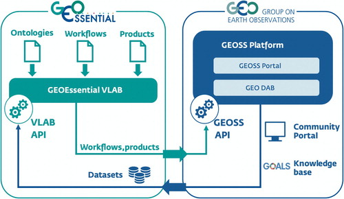
The GVL is based on previous experiences carried out in the context of GEO-related projects and initiatives such as the European Union H2020 project ECOPotential (Provenzale and Nativi Citation2017). To leverage the data management services provided by the GEOSS Platform, GVL implements a two-way interoperability with the GEOSS Platform – by accessing GEOSS datasets on one side, and publishing data, products and workflow description to GEOSS (see ).
Figure 3. Interoperability of the GEOEssential Virtual laboratory and the GEOSS Platform.
8. Dashboard
The GEOEssential Dashboard will be the visual front-end, exposing the major outputs/results of the different thematic workflows on biodiversity and ecosystems (Dantas de Paula et al. Citation2019), ecosystems, extractives (Ambrosone et al. Citation2019), night light, and the food-water-energy nexus (McCallum et al. Citation2019), while using the GEOSS platform capacities (Nativi et al. Citation2019). Through a set of dedicated modules, it will allow users to discover and access various Essential Variables, track progresses towards SDGs using official UN statistics, compute a selection of SDG indicators using Earth observation data, and explore different pilot studies related to SDG monitoring using EO data (e.g. Data Cubes, ECV and EBV monitoring).
Where possible, the GEOEssential Dashboard will use the GEOSS platform tools such as the GEOSS API, GEOSS View, GEOSS Mirror, and GEOSS Widget. GEOEssential Dashboard will demonstrate the data value chain from EVs to indicators (e.g. SDG). The Dashboard will be a generic (i.e. applicable to other indicators), replicable (i.e. expandable to other contexts), and scalable (i.e. national to regional to global) open web-based platform, automating the transformation of Earth Observation data into indicators (as graphs or/and maps) through EVs. This will show that EO, when matched with appropriate tools and services, can contribute to filling the gap between science and policy for decisions, management and reporting. It will expose the data sources, essential variables and derived indicators as dynamic maps and graphs, that can be structured and explained to different end users as story maps.
9. Conclusions
By linking policy needs with EVs data services, GEOEssential is enhancing the existing knowledge base infrastructures dealing with EVs, at the Global, Pan-European, and National scales. Presently, the GEOSS knowledge base is implemented as a searchable database according to selected topics. The proposed solution is going further by implementing a business ecosystem platform for the management and sharing of a set of knowledge bodies, including: datasets, processing artifacts, business process models (implemented as workflows), and publications. This result is obtained by bringing together existing GEOSS resources (e.g. data and organization descriptions) with newly ones (e.g. processing services and workflows), provided by the new ecosystem components, and linked together by means of the GEOEssential ontology model.
The project is filling the identified gaps in the definition and selection of EVs, in collaboration with the respective communities of practice, stakeholders and identified users. Among the GEO SBAs, different levels of EV maturity were found, in terms of their recognition and acceptance, their real applicability and use, the specification of observational requirements, the methodological approach, the measuring capabilities, technological, networking and infrastructural issues and gaps. While the SBA’s EVs are still not completely defined, each sub-community of practice tends to develop its own set of EVs. One could wonder that if everything becomes essential then nothing really remains essential. It seems therefore important to quickly reinforce the definition of EVs for each SBA in order to encourage other users to first look in the lists of existing EVs before defining new sets. If new sets are really necessary, they should be based on clear definition of what an Essential Variable is or should be. Our recommendation would be to use the initial Essential Climate Variables as the example to follow when defining EVs. This approach will help to gain interoperability between different sets of EVs in order to allow the development of cross-cutting EVs for SDGs or Nexus approaches as collections of existing EVs from different SBAs.
GEOEssential aims at improving the availability of EVs services from GEOSS and Copernicus platforms. Indeed, the development made in GEOEssential will be fully integrated in the GEOSS platform providing new datasets and services interoperability – by implementing a set of Key Enabling Technologies (KETs). These technologies will contribute to the GEOSS Platform extension and in particular the GEO DAB with the introduction of a Virtual Laboratory infrastructure that is capable of defining and executing well-specified workflows. The expected GEOEssential outputs are:
The improvement of interoperability among observational, modeling, data assimilation and prediction systems, to maximize value and benefits of EO investments;
The improvement of the link between in-situ and satellite observations for all parameters that are relevant to understand environmental processes in agriculture, hydrology, ecosystem analysis, mining and energy production, and their impact on natural ecosystems and human health;
The coordination of the KETs developed/utilized in environmental monitoring and policy domain;
The provision of useful guidance of good practices and standards for in-situ data use and Earth observation technology, at the European and National levels;
The promotion of synergetic and complementary advances in enabling technologies for the access and re-use (i.e. the interoperability) of Earth observation resources (e.g. data, best practices, services, and models); and
The enablement of cross and inter-disciplinary research on various scientific and policy relevant topics, related to environmental research, through Earth observation resources interoperability.
The GEOEssential Hub will present a dashboard and interactive story maps presenting dedicated workflows bridging data sources with policy indicators through Essential Variables by navigating the ontology built in the knowledge base. This approach will contribute to move GEOSS from a data discovery and access infrastructure towards a knowledge-oriented platform. It will demonstrate the benefits of Earth observations to provide timely indicators relating to the past, present and future status of international, European and national environmental and sustainability policies.
Acknowledgements
The authors wish to acknowledge the main contribution of the H2020 ERA-PLANET project No. 689443, as well as the contribution of all partners of the project.
Disclosure statement
No potential conflict of interest was reported by the authors.
ORCID
Anthony Lehmann http://orcid.org/0000-0002-8279-8567
Stefano Nativi http://orcid.org/0000-0003-3185-8539
Paolo Mazzetti http://orcid.org/0000-0002-8291-1128
Aidin Niamir http://orcid.org/0000-0003-4511-3407
Grégory Giuliani http://orcid.org/0000-0002-4696-5313
Additional information
Funding
References
- Allouche, J., C. Middleton, and D. Gyawali. 2014. “Nexus Nirvana or Nexus Nullity? A Dynamic Approach to Security and Sustainability in the Water-energy-food Nexus.” STEPS Working Paper 63. Brighton: STEPS Centre.
- Ambrosone, M., G. Giuliani, B. Chatenoux, D. Rodila, and P. Lacroix. 2019. “Definition of Candidate Essential Variables for the Monitoring of Mineral Resources Exploitation.” Submitted to Geo-spatial Information Science.
- Biggs, E. M., E. Bruce, B. Boruff, J. M. A. Duncan, J. Horsley, N. Pauli, K. McNeill, et al. 2015. “Sustainable Development and the Water-energy-food Nexus: A Perspective on Livelihoods.” Environmental Science & Policy 54: 389–397. doi:10.1016/j.envsci.2015.08.002.
- BISE. 2018. “Interactive Presentation of the EU Biodiversity Strategy - Mid-term Review.” Accessed November 2018. https://biodiversity.europa.eu/mtr/biodiversity-strategy-plan.
- Bojinski, S., M. Verstraete, T. C. Peterson, C. Richter, A. Simmons, and M. Zemp. 2014. “The Concept of Essential Climate Variables in Support of Climate Research, Applications, and Policy.” Bulletin of the American Meteorological Society 95 (9): 1431–1443. doi:10.1175/Bams-D-13-00047.1.
- Brandi, C. 2015. “Safeguarding the Earth System as a Priority for Sustainable Development and Global Ethics: The Need for an Earth System SDG.” Journal of Global Ethics 11 (1): 32–36. doi:10.1080/17449626.2015.1006791.
- Brooks, T. M., S. H. M. Butchart, N. A. Cox, M. Heath, C. Hilton-Taylor, M. Hoffmann, N. Kingston, J. P. Rodríguez, S. N. Stuart, and J. Smart. 2015. “Harnessing Biodiversity and Conservation Knowledge Products to Track the Aichi Targets and Sustainable Development Goals.” Biodiversity 16 (2-3): 157–174. doi:10.1080/14888386.2015.1075903.
- ConnectinGEO. 2016a. “D2.1: Navigating Sustainability in a Changing Planet.”
- ConnectinGEO. 2016b. “D2.2: EVs Curent Status in Different Communities and Way to Move Forward.”
- ConnectinGEO. 2016c. “D2.3: Proposal of EVs for Selected Theems.”
- ConnectinGEO. 2017. “D7.4: Strategic View for the Sustainability of ENEON after the End of the Project.”
- Constable, A. J., D. P. Costa, O. Schofield, L. Newman, E. R. Urban, E. A. Fulton, J. Melbourne-Thomas, et al. 2016. “Developing Priority Variables (‘Ecosystem Essential Ocean Variables’ – eEOVs) for Observing Dynamics and Change in Southern Ocean Ecosystems.” Journal of Marine Systems 161: 26–41. doi:10.1016/j.jmarsys.2016.05.003.
- Dantas de Paula, M., M. Gomez-Gomenez, A. Niamir, and T. Hickler. 2019. “The Potential of European Earth Observation Products for Driving and Evaluating Process-based Ecosystem Models.” IJDE this issue.
- EC. 2014. “2030 Climate & Energy Framework.” Accessed November 2018. https://ec.europa.eu/clima/policies/strategies/2030_en.
- EC. 2015. The Monitoring and Evaluation Framework for the Common Agricultural Policy. Luxemburg: Publications Office of the European Union. doi:10.2762/63927.
- EC. 2018. “Water.” Accessed November 2018. http://ec.europa.eu/environment/water/index_en.htm.
- EEA. 2014. “Digest of EEA Indicators 2014.” EEA technical report, Luxenburg.
- EEA. 2017. “EEA Indicators.” Accessed November 2018. https://www.eea.europa.eu/data-and-maps/indicators/about.
- EITI. 2016. “How the EITI Contributes Towards Meeting the Sustainable Development Goals.” Accessed November 2018. https://eiti.org/document/how-eiti-contributes-towards-meeting-sustainable-development-goals.
- EODC. 2018. “Earth Observation Data Centre for Water Resources Monitoring.” Accessed November 2018. https://www.eodc.eu.
- ESA. 2018. “Copernicaus.” Accessed November 2018. https://www.esa.int/Our_Activities/Observing_the_Earth/Copernicus/Overview3.
- Eurostat. 2017. “Sustainable Development in the European Union - Monitoring Report on Progress Towards the SDGs in an EU Context.” Luxenburg.
- Fasel, M., C. Brethaut, E. Rouholahnejad, M. A. Lacayo-Emery, and A. Lehmann. 2016. “Blue Water Scarcity in the Black Sea Catchment: Identifying Key Actors in the Water-ecosystem-energy-food Nexus.” Environmental Science & Policy 66: 140–150. doi:10.1016/j.envsci.2016.09.004.
- Geijzendorffer, I. R., E. Cohen-Shacham, A. F. Cordd, W. Cramer, C. Guerra, and B. Martín-López. 2017. “Ecosystem Services in Global Sustainability Policies.” Environmental Science and Policy 74: 40–48. doi: 10.1016/j.envsci.2017.04.017
- Geijzendorffer, I. R., E. C. Regan, H. M. Pereira, L. Brotons, N. Brummitt, Y. Gavish, P. Haase, et al. 2016. “Bridging the Gap Between Biodiversity Data and Policy Reporting Needs: An Essential Biodiversity Variables Perspective.” Journal of Applied Ecology 53 (5): 1341–1350. doi:10.1111/1365-2664.12417.
- GEO. 2017a. “Earth Observations in Support of the 2030 Agenda for Sustainable Development.” Accessed November, 2018. https://www.earthobservations.org/documents/publications/201703_geo_eo_for_2030_agenda.pdf.
- GEO. 2017b. “2017–2019 GEO Work Programme.” Accessed November 2018. https://www.earthobservations.org/geoss_wp.php.
- Giampietro, M., and S. G. F. Bukkens. 2015. “Analogy Between Sudoku and the Multi-scale Integrated Analysis of Societal Metabolism.” Ecological Informatics 26: 18–28. doi:10.1016/j.ecoinf.2014.07.007.
- Giampietro, M., and K. Mayumi. 2000. “Multiple-scale Integrated Assessments of Societal Metabolism: Integrating Biophysical and Economic Representations Across Scales.” Population and Environment 22 (2): 155–210. doi:10.1023/A:1026643707370.
- Griggs, D., M. Stafford-Smith, O. Gaffney, J. Rockstrom, M. C. Ohman, P. Shyamsundar, W. Steffen, G. Glaser, N. Kanie, and I. Noble. 2013. “Sustainable Development Goals for People and Planet.” Nature 495 (7441): 305–307. doi: 10.1038/495305a
- Griggs, D., M. Stafford-Smith, J. Rockstrom, M. C. Ohman, O. Gaffney, G. Glaser, N. Kanie, I. Noble, W. Steffen, and P. Shyamsundar. 2014. “An Integrated Framework for Sustainable Development Goals.” Ecology and Society 19 (4). doi:10.5751/Es-07082-190449.
- Guerry, A. D., S. Polasky, J. Lubchenco, R. Chaplin-Kramer, G. C. Daily, R. Griffin, M. Ruckelshaus, et al. 2015. “Natural Capital and Ecosystem Services Informing Decisions: From Promise to Practice.” Proceedings of the National Academy of Sciences of the United States of America 112 (24): 7348–7355. doi:10.1073/pnas.1503751112.
- Hayes, K. R., J. M. Dambacher, G. R. Hosack, N. J. Bax, P. K. Dunstan, E. A. Fulton, P. A. Thompson, et al. 2015. “Identifying Indicators and Essential Variables for Marine Ecosystems.” Ecological Indicators 57: 409–419. doi:10.1016/j.ecolind.2015.05.006.
- Hoff, H. 2011. “Understanding the Nexus.” Paper presented at the Nexus Conference, Bonn.
- Hollmann, R., C. J. Merchant, R. Saunders, C. Downy, M. Buchwitz, A. Cazenave, E. Chuvieco, et al. 2013. “THE ESA CLIMATE CHANGE INITIATIVE Satellite Data Records for Essential Climate Variables.” Bulletin of the American Meteorological Society 94 (10): 1541–1552. doi:10.1175/Bams-D-11-00254.1.
- ICSU. 2015. “Review of Targets for the Sustainable Development Goals: The Science Perspective.”
- IEA. 2018. “Sustainable Development Goal 7.” Accessed November 2018. https://www.iea.org/sdg.
- IPBES. 2016. “Summary for Policymakers of the Assessment Report of the Methodological Assessment of Scenarios and Models of Biodiversity and Ecosystem Services.”
- IPBES. 2018. “Summary for Policymakers of the Assessment Report on Land Degradation and Restoration.”
- IPCC. 2014. “Climate Change 2014: Impacts, Adaptation, and Vulnerability. Part A: Global and Sectoral Aspects.” Contribution of Working Group II to the Fifth Assessment Report of the Intergovernmental Panel on Climate Change. Cambridge, UK: Cambridge University Press and New York, NY, USA, 1132.
- Lacroix, P., F. Moser, A. Benvenuti, T. Piller, D. Jensen, I. Petersen, M. Planque, and N. Ray. In press. “MapX: An Open Geospatial Platform to Manage, Analyse and Visualise Data on Natural Resources and the Environment.” SoftwareX.
- Lausch, A., L. Bannehr, M. Beckmann, C. Boehm, H. Feilhauer, J. M. Hacker, M. Heurich, et al. 2016. “Linking Earth Observation and Taxonomic, Structural and Functional Biodiversity: Local to Ecosystem Perspectives.” Ecological Indicators 70: 317–339. doi:10.1016/j.ecolind.2016.06.022.
- Lawford, R. 2014. The GEOSS Water Strategy: From Observations to Decisions. Japan Aerospace Exploration Agency.
- Lehmann, A., R. Chaplin-Kramer, M. Lacayo, G. Giuliani, D. Thau, K. Koy, G. Goldberg, and R. Sharp Jr. 2017a. “Lifting the Information Barriers to Address Sustainability Challenges with Data from Physical Geography and Earth Observation.” Sustainability 9 (5). doi:10.3390/su9050858.
- Lehmann, A., G. Giuliani, E. Mancosu, K. C. Abbaspour, S. Soezen, D. Gorgan, A. Beel, and N. Ray. 2015. “Filling the Gap Between Earth Observation and Policy Making in the Black Sea Catchment with enviroGRIDS.” Environmental Science & Policy 46: 1–12. doi:10.1016/j.envsci.2014.02.005.
- Lehmann, A., G. Giuliani, N. Ray, K. Rahman, K. C. Abbaspour, S. Nativi, M. Craglia, D. Cripe, P. Quevauviller, and M. Beniston. 2014. “Reviewing Innovative Earth Observation Solutions for Filling Science-policy Gaps in Hydrology.” Journal of Hydrology 518: 267–277. doi:10.1016/j.jhydrol.2014.05.059.
- Lehmann, A., Y. Guigoz, N. Ray, E. Mancosu, K. C. Abbaspour, E. R. Freund, K. Allenbach, et al. 2017b. “A Web Platform for Landuse, Climate, Demography, Hydrology and Beach Erosion in the Black Sea Catchment.” Scientific Data 4. doi:10.1038/sdata.2017.87.
- Lu, Y. L., N. Nakicenovic, M. Visbeck, and A. S. Stevance. 2015. “Five Priorities for the UN Sustainable Development Goals.” Nature 520 (7548): 432–433. doi: 10.1038/520432a
- Mannion, P. 2015. “Optimal Analysis Algorithms are IoT’s Big Opportunity.” IEEE Electronics360.
- Masò, J., I. Serral, C. Domingo-Marimon, and A. Zabala Torres. 2019. “Earth Observations Observatory for Sustainable Development Goals Monitoring Based on a Comprehensive Definition of Essential Variables.” IJDE this issue.
- McCallum, I., S. Fritz, N. Kussul, A. Lehmann, J. Masò, C. Montzka, I. Serral, and D. Spengler. 2019. “Addressing the Food Water Energy Nexus with Earth Observation.” IJDE this issue.
- Miranda Espinosa, M. T., G. Giuliani, and N. Ray. 2019. “Essential Climate Variables: Reviewing the Accessibility to Data and Information Product.” IJDE this issue.
- Naeem, S., J. C. Ingram, A. Varga, T. Agardy, P. Barten, G. Bennett, E. Bloomgarden, et al. 2015. “Get the Science Right When Paying for Nature's Services.” Science 347 (6227): 1206–1207. doi:10.1126/science.aaa1403.
- Nativi, S., M. Craglia, and J. Pearlman. 2013. “Earth Science Infrastructures Interoperability: The Brokering Approach.” IEEE Journal of Selected Topics in Applied Earth Observations and Remote Sensing 6 (3): 1118–1129. doi:10.1109/Jstars.2013.2243113.
- Nativi, S., M. Santoro, G. Giuliani, and P. Mazzetti. 2019. “Towards a GEOSS Knowledge Base.” IJDE this issue.
- Patias, P., N. Verde, G. Mallinis, C. Georgiadis, G. Giuliani, J. Masò, I. Serral, et al. 2019. “The Use of Earth Observation Data and their Essential Variables in Support to UN Sustainable Development Goals.” IJDE this issue.
- Pereira, H. M., S. Ferrier, M. Walters, G. N. Geller, R. H. G. Jongman, R. J. Scholes, M. W. Bruford, et al. 2013. “Essential Biodiversity Variables.” Science 339 (6117): 277–278. doi:10.1126/science.1229931.
- Provenzale, A., and S. Nativi. 2017. “Comprehensive and Coordinated Approach of GEOSS to Ecosystem Challenges.” In Terrestrial Ecosystem Research Infrastructures, edited by A. Chabbi and W. Loescher, 369–398. Boca Raton: CRC Press. do:10.1201/9781315368252.
- Raworth, K. 2012. “A Safe and Just Space for Humanity: Can We Live Within the Doughnut?” Oxfam Discussion Paper.
- Reyers, B., M. Stafford-Smith, K.-H. Erb, R. J. Scholes, and O. Selomane. 2017. “Essential Variables Help to Focus Sustainable Development Goals Monitoring.” Current Opinion in Environmental Sustainability 26–27: 97–105. doi:10.1016/j.cosust.2017.05.003.
- Rockstrom, J., W. Steffen, K. Noone, A. Persson, F. S. Chapin, E. F. Lambin, T. M. Lenton, et al. 2009. “A Safe Operating Space for Humanity.” Nature 461 (7263): 472–475. doi:10.1038/461472a.
- Rowley, J. 2007. “The Wisdom Hierarchy: Representations of the DIKW Hierarchy.” Journal of Information Science 33: 163–180. doi: 10.1177/0165551506070706
- Ruckelshaus, M., E. McKenzie, H. Tallis, A. Guerry, G. Daily, P. Kareiva, S. Polasky, et al. 2015. “Notes from the Field: Lessons Learned from Using Ecosystem Service Approaches to Inform Real-world Decisions.” Ecological Economics 115: 11–21. doi:10.1016/j.ecolecon.2013.07.009.
- Sachs, J. D. 2012. “From Millennium Development Goals to Sustainable Development Goals.” Lancet 379 (9832): 2206–2211. doi: 10.1016/S0140-6736(12)60685-0
- Santoro, M., F. Papeschi, R. Roncella, P. Mazzetti, and S. Nativi. 2016. “The GEOSS Discovery and Access Broker APIs.” Online Document. http://www.geodab.net/apis.
- Scholes, R. J., M. Walters, E. Turak, H. Saarenmaa, C. H. R. Heip, E. O. Tuama, D. P. Faith, et al. 2012. “Building a Global Observing System for Biodiversity.” Current Opinion in Environmental Sustainability 4 (1): 139–146. doi:10.1016/J.Cosust.2011.12.005.
- Skidmore, A. K., N. Pettorelli, N. C. Coops, G. N. Geller, M. Hansen, R. Lucas, C. A. Mucher, et al. 2015. “Agree on Biodiversity Metrics to Track from Space.” Nature 523 (7561): 403–405. doi: 10.1038/523403a
- Steffen, W., K. Richardson, J. Rockstrom, S. E. Cornell, I. Fetzer, E. M. Bennett, R. Biggs, et al. 2015. “Planetary Boundaries: Guiding Human Development on a Changing Planet.” Science 347 (6223): 736. doi:10.1126/science.1259855.
- Szczypta, C., J. C. Calvet, F. Maignan, W. Dorigo, F. Baret, and P. Ciais. 2014. “Suitability of Modelled and Remotely Sensed Essential Climate Variables for Monitoring Euro-mediterranean Droughts.” Geoscientific Model Development 7 (3): 931–946. doi:10.5194/gmd-7-931-2014.
- UNSTAT. 2018. “Global Indicator Framework for the Sustainable Development Goals and Targets of the 2030 Agenda for Sustainable Development.” Accessed November 2018. https://unstats.un.org/sdgs/indicators/indicators-list.
- UNWATER. 2018. “Sustainable Development Goal 6 and Its Targets and Global Indicators.” Accessed November 2018. http://www.sdg6monitoring.org/indicators.
- Waage, J., C. Yap, S. Bell, C. Levy, G. Mace, T. Pegram, E. Unterhalter, et al. 2015. “Governing the UN Sustainable Development Goals: Interactions, Infrastructures, and Institutions.” Lancet Global Health 3 (5): E251–E2E2. doi:10.1016/s2214-109x(15)70112-9.
- Weitz, N., M. Nilsson, and M. Davis. 2014. “A Nexus Approach to the Post-2015 Agenda: Formulating Integrated Water, Energy, and Food SDGs.” SAIS Review of International Affairs 34: 37–50. doi: 10.1353/sais.2014.0022
- Wheeler, Q. D. 2004. “What if GBIF?” Bioscience 54 (8): 717. doi: 10.1641/0006-3568(2004)054[0718:WIG]2.0.CO;2
- Zeng, Y., Z. Su, J. C. Calvet, T. Manninen, E. Swinnen, J. Schulz, R. Roebeling, et al. 2015. “Analysis of Current Validation Practices in Europe for Space-based Climate Data Records of Essential Climate Variables.” International Journal of Applied Earth Observation and Geoinformation 42: 150–161. doi:10.1016/j.jag.2015.06.006.
- Zhao, Z., P. Martin, P. Grosso, W. Los, C. de Laat, K. Jeffrey, A. Hardisty, A. Vermeulen, D. Castelli, Y. Legre, and W. Kurtsch. 2015. “Reference Model Guided System Design and Implementation for Interoperable Environmental Research Infrastructures.” IEEE 11th International Conference on e-Science, Munich, 551–556. doi:10.1109/eScience.2015.41.