
ABSTRACT
The advancements of sensing technologies, including remote sensing, in situ sensing, social sensing, and health sensing, have tremendously improved our capability to observe and record natural and social phenomena, such as natural disasters, presidential elections, and infectious diseases. The observations have provided an unprecedented opportunity to better understand and respond to the spatiotemporal dynamics of the environment, urban settings, health and disease propagation, business decisions, and crisis and crime. Spatiotemporal event detection serves as a gateway to enable a better understanding by detecting events that represent the abnormal status of relevant phenomena. This paper reviews the literature for different sensing capabilities, spatiotemporal event extraction methods, and categories of applications for the detected events. The novelty of this review is to revisit the definition and requirements of event detection and to layout the overall workflow (from sensing and event extraction methods to the operations and decision-supporting processes based on the extracted events) as an agenda for future event detection research. Guidance is presented on the current challenges to this research agenda, and future directions are discussed for conducting spatiotemporal event detection in the era of big data, advanced sensing, and artificial intelligence.
1. Introduction
Spatiotemporal events are occurrences of interest to specific stakeholders and happen at a particular time and location. Examples include natural hazard events, environmental pollution events, health events, urban-related events, business events, and crisis/crime events. Many events bring adverse impacts on the environment and society. For example, natural hazards cost the U.S. $91 billion in 2018 due to 14 hazard events (NCEI Citation2019); Ebola has inflicted upon the Democratic Republic of the Congo 630 disease cases including 385 deaths since the outbreak in 1976 (ECDC Citation2019); Natural resource contamination events are costing $4.6 trillion per year in the US (Landrigan et al. Citation2018). It is crucial to detect the events in real-time and with high accuracy for responding to the challenges to reduce the cost to society, both in lives and in money. For public health events, the Defense Advanced Research Projects Agency (DARPA) estimated that fatalities can be reduced by a factor of six if the detection time can be advanced by just two days (Neill Citation2012). However, traditional event extraction methods require reactive human identification or intervention, which significantly reduces the efficiency of event detection (Shi et al. Citation2018) in addition to the high latency of transmitting sensing data. The latest improvements in sensing capabilities, event extraction methods, and event applications provide new opportunities to facilitate potential timely detections of events. To better understand the emerging technologies and identify future research for enabling such timely detection, we review the latest advances in sensing (Section 2), event extraction methods (Section 3), event applications (Section 4), and discuss the current challenges and future directions (Section 5) in the era of big data (Yang et al. Citation2019b) and artificial intelligence.
1.1. Definition of a spatiotemporal event
The term ‘event’ has been used a lot in literature with specific examples but seldom defined. An ‘event’ can be defined in three stages progressively () with the first as ‘something that happens at a particular time and place’ (Allan et al. Citation1998). This definition broadly represents an event in three aspects of what, where, and when, and is accepted in many applications, such as Earth observation, in situ sensing, and environmental monitoring and management (Guillem and Mograss Citation2005; Metzler, Cai, and Hovy Citation2012; Atefeh and Khreich Citation2015). Nevertheless, the definition ignores the process of event including beginnings, duration, ends, and can move across or involve multiple locations, and can be a compound event that has internal events.
Figure 1. Spatiotemporal event definitions.
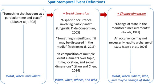
The second popular ‘event’ definition is ‘a specific occurrence involving participants’ (Linguistic Data Consortium Citation2005) by adding the human or agent factor, who, into the aspects. This definition has been largely accepted in computer science and applied fields (Chen, Ji, and Haralick Citation2009; Elkhlifi and Faiz Citation2010; Chen et al. Citation2015), media and communication (McMinn, Moshfeghi, and Jose Citation2013), and social sciences (Zhou and Chen Citation2014) for studies on social sensing, wearable sensors, health monitoring and management, urban and business intelligence, and crisis, crime, and social unrest.
The third popular ‘event’ definition is a ‘change of state’ in the monitored measurement (Kopetz Citation1991) and is shared by a number of approaches in signal processing (Nevatia, Hobbs, and Bolles Citation2004; Caudal and Nicolas Citation2005; Hühn Citation2009; Meira-Machado et al. Citation2009). For example, a precipitation event occurs when the rate of precipitation suddenly increases (Steele, Goldstein, and Browne Citation2004). This definition was followed by some publications related to Earth observation, in situ sensing, wearable sensors, environmental monitoring and management, and urban intelligence.
1.2. Requirements of event detection
Spatiotemporal events are complex, dynamic, and context dependent (Ravanbakhsh et al. Citation2017). Events extracted from various data sources, such as text, imagery, and videos, are related to the characters of the adjacent content (Lee et al. Citation2015) or disseminated to people and groups affected in a situational awareness fashion. For example, the detection of wildfire needs specific local conditions (closed roads, wind speed and direction, flame height, etc.) for evacuation or routing first-responders (Paschke, Kozlenkov, and Boley Citation2010). Existing event detection knowledge with situational awareness is usually domain-dependent, based on human annotation or intervention (Mertens et al. Citation2011) and hard to generalize for cross-domain applications (Kittler et al. Citation2014).
Spatiotemporal events require monitoring and detection with high accuracy and reliability in content (i.e. whether the event is semantically correct), location, and time to facilitate decision support (Crooks et al. Citation2013; Liu Citation2018). For example, disaster relief needs location information as accurate as possible for urgent responses (Singh et al. Citation2017). Reliability of event detection is critical with trustworthiness and performance consistency for, e.g. protecting drivers from injury and loss of life when detecting a crash. High reliability of energy consumption event detection can contribute to energy conservation and sustainability.
Event detection tasks have different timeliness or real-time requirements ranging from seconds, minutes, days, to a longer time. For example, earthquake warnings are valuable if they precede the earth-shaking that causes damage even a few seconds. Disease outbreak events can be planned for if we can timely index the patients and identify their close contacts during the epidemiologic and clinical investigation (Shmueli and Burkom Citation2010), e.g. in the coronavirus disease 2019 (COVID-19; WHO Citation2020). On the other hand, suspicious maritime events, such as arrival at critical points of a vessel trajectory, should be detected within seconds to enable action if necessary (Patroumpas et al. Citation2017). However, it is challenging to conduct real-time detection due to sensor limitations, data transmission, and semantic ambiguity issues (Tan et al. Citation2010; Lejeune et al. Citation2015).
1.3. Spatiotemporal event detection workflow
Instead of considering event detection as the event extraction method alone, we consider spatiotemporal event detection as a collection of processes starting with the sensing, extraction of events of interest, and the applications of actionable events detected ().
Figure 2. Spatiotemporal event detection workflow.
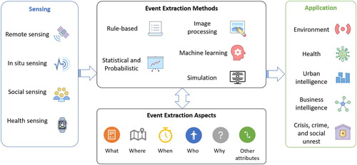
Event extraction methods focus on understanding the entirety and complexity of an event by identifying (1) the theme or occurrence (i.e. what), (2) the spatial information, such as location or boundary (i.e. where), (3) the temporal information, such as date, time and duration (i.e. when), (4) the participants (i.e. who), and (5) thematic attributes, such as environmental, infrastructural, and social/societal characteristics. Causes and consequences of events may also be identified (i.e. why).
1.4. Review approach
We followed a systematic approach by selecting papers related to ‘event detection’ and ‘spatiotemporal.’ We identified 4,770 publications in Google Scholar and 623 from the Web of Science. We removed duplicates and obtained 4973 papers, and 265 articles were selected based on their keywords most relevant to our topic. Full-text articles were assessed for cutting-edge, centrality to spatiotemporal event detection to reach 132 articles in this review.
2. Sensing
Four major categories of sensing capabilities are summarized and compared for their data sources, characteristics, and major event detection tasks ().
Table 1. Data sources, characteristics, and major event detection tasks for each type of sensing capability.
2.1. Remote sensing
Sensing the Earth remotely has been steadily improved with increased spatial resolution, all-weather imaging, increased spectral resolution, more detailed and frequent viewing, and smaller cost-effective satellites. As a result, events can be detected offline or in real-time and fed into applications such as automated detection and warning systems for planning, policymaking, natural disasters, weather events, crime, and pollution.
Satellites and aboard instruments have been observing optically and thermally the Earth surface for different detections. For example, Landsat 8 (30 m and 16 days revisit) is used for long-term decadal land-use change and fire effect detection (Soulard et al. Citation2016); Moderate Resolution Imaging Spectroradiometer (MODIS, 1 km and daily revisit) is used for daily active fire detection (Giglio, Schroeder, and Justice Citation2016); Sentinel 2 (10–50 m and 5 days revisit) is used for detailed agricultural monitoring (Bontemps et al. Citation2015). The recently launched Geostationary Operational Environmental Satellite (GOES)-R series (5-mins and 0.5 km) provide environmental monitoring, including for hurricanes, lightning strikes, and wildfires for the entire Western Hemisphere.
Active sensors provide clear images with high penetration that enables better capture of surface targets in nearly all-weather and all-time. For example, Synthetic Aperture Radar (SAR) and Light Detection and Ranging (LIDAR) have supported the dynamic monitoring of vegetation and soil moisture (Qiu et al. Citation2019), ground object change detection (Li et al. Citation2018), and agricultural cultivation area identification (Tian et al. Citation2019). LiDAR has also been used in autonomous driving to provide distance measurement (Beer et al. Citation2018).
Very-high-resolution (VHR) optical images (such as Geoeye, Quickbird, and Worldview) and very-high-resolution SAR images (such as Cosmo-Skymed and TerraSAR-X) offer meter or sub-meter resolution (Tapete and Cigna Citation2018) for monitoring detailed surface features that could not be captured before, such as inner water areas, complex land ecosystems, and maritime zones (Nguyen, Kopec, and Netzband Citation2016; Ibarrola-Ulzurrun et al. Citation2017).
Hyperspectral and multispectral imaging compose of multiple, 100s, and up to 1000 bands can detect and monitor much more detailed Earth surface targets for, e.g. crop health monitoring, mineral inspection, and fine-scale monitoring of hazardous pollutants (Debba et al. Citation2005; Adam, Mutanga, and Rugege Citation2010; Manolakis et al. Citation2013).
More recently, increasing numbers of cost-effective small satellites are being developed and launched (Nervold et al. Citation2016; Madry, Martinez, and Laufer Citation2018) to provide a low-cost platform for various missions, such as establishing constellations for low-cost communication systems and education in satellite development and operation (Gao et al. Citation2018). Similarly, short-observation time and lightweight hyperspectral imaging sensors have been embedded in unmanned aerial vehicles (UAVs) to provide high spatial resolution (1–50 cm) and flexible operational feasibilities (Zhong et al. Citation2018).
2.2. In situ sensing
Rather than sensing remotely from satellites or aircraft, in situ sensing provides measurements by sensors that are directly located in the environment such as the Earth’s surface, measurement towers, or balloons (Durry and Pouchet Citation2001; Lawrence and Balsley Citation2013). In-situ sensors can produce high temporal resolution data instantly and therefore facilitating real-time event detection (Hill, Minsker, and Amir Citation2007), such as air quality pollution, metabolites in water bodies, the concentration of carbon dioxide (CO2) in living environment.
More recently, wireless sensor networks (WSN) and the Internet of Things (IoT) have provided new opportunities for real time and high-resolution monitoring in a distributed network. The flexible distribution of sensors in a WSN facilitates a customized network for various purposes, such as volcano event detection from monitoring sensors (Werner-Allen et al. Citation2006), spatially and temporally continuous air quality monitoring (Boubrima, Bechkit, and Rivano Citation2017), and earthquake detection from a distributed acoustic sensor network on regional fiber-optic telecommunication infrastructure (Ajo-Franklin et al. Citation2019). Compared to the WSN, an IoT system refers to a large collection of sensors used to individually gather and send data through a router to the Internet. In IoT, wireless sensors usually produce a massive volume of high-temporal-resolution data when deployed for fast information extraction and near-real-time applications (Bhuiyan and Wu Citation2016). This is particularly so when combining high-quality sensing devices with standardized sensing infrastructures to ensure portability and interoperability, paving the way towards the vision of a ‘digital earth’ (Resch, Blaschke, and Mittlboeck Citation2010; Chen et al. Citation2014).
Underwater sensor networks and the Internet of Underwater Things (IoUT) have also been proposed to monitor underwater ecology and enhance tsunami warning systems (Kao et al. Citation2017) with acoustic modems placed in shallow or deep water to detect novel marine animals and extreme events (Cong et al. Citation2019).
To deal with the heterogeity, labor-intensive processing and redundancy challenges, studies have been conducted targeting data fusion and standardization (Zhou et al. Citation2016; Yang et al. Citation2018), and energy reduction and prolonged lifetime of sensors in the sensor environment.
2.3. Social sensing
Social sensing utilizes human sensing capabilities faciliated by location-based devices such as mobile phones and Global Positioning System (GPS) trackers (Liu et al. Citation2015), and social media platforms (Aggarwal and Abdelzaher Citation2012). Aggregating individually sensed data could collaboratively represent the group behaviors of a social network (Rosi et al. Citation2011), such as traffic conditions in an urban area based on GPS sensors, epidemiology behavior changes and interactions from mobile phone co-location (Madan et al. Citation2010), or the public’s reaction, sentiments and emotions to certain events (Resch et al. Citation2015a, Citation2015b).
The emerging social media platforms allow the public to report information ranging from daily life to the latest news intentionally or unintentionally (Xiao, Huang, and Wu Citation2015; Li et al. Citation2019). Spatiotemporal events commonly trigger the public to share information in various forms, such as text, voice, images, and videos. The information is especially valuable for event detection processes in a timely fashion, such as disaster or crisis management, when authoritative data are unavailable or not ready (Sakaki, Okazaki, and Matsuo Citation2010; Zhang et al. Citation2016; Li, Huang, and Emrich Citation2019).
Besides social media, Volunteered Geographic Information (VGI) (Goodchild Citation2007) frameworks is also used to collect data from volunteers and map the impacts or aftermath of natural disaster events through a developed web or mobile application (Longueville et al. Citation2010). VGI frameworks can also assist military missions or emergency responses to obtain real-time situational awareness of group behaviors and physical events (Jayarajah et al. Citation2015), such as the Federal Emergency Management Agency (FEMA) app (FEMA Citation2019).
Except the real-time and informational benefit, social sensing data may contain a significant amount of noise (Huang et al. Citation2019). Filtering mechanisms have been adopted to extract relevant data and eliminate information that are less trustworthy (Huang et al. Citation2018; Yang et al. Citation2019c) Furthermore, the multilingual challenge in the messages published on these platforms also needs to be addressed to better understand and categorize the extracted information (Dang et al. Citation2014; Lo, Chiong, and Cornforth Citation2017).
2.4. Health sensing
Health sensing uses wearable sensors in direct contact with a humanbody to monitor the health conditions. These sensors have been used to detect abnormal fall events for people with disabilities or the elderly (Mubashir, Shao, and Seed Citation2013), identify behaviors in sports activities, such as snowboarding and football (Kautz, Groh, and Eskofier Citation2015; Groh, Fleckenstein, and Eskofier Citation2016), detect whether a person is in a dangerous situation subject to crime or physical violence (López-Cuevas et al. Citation2017), or reveal mental health issues for citizens (Rodrigues et al. Citation2015). These wearable sensors leverage the advancement of information and communications technology (ICT) to collect health-related information directly but remotely for doctors and health facilities (Gao et al. Citation2016; Varatharajan et al. Citation2018).
Wearable sensors have low power consumption and high energy efficiency. A recent study shows that the quality of data acquired with low-cost (yet certified) wearable sensor technology is comparable to traditional laboratory equipment (Sagl et al. Citation2019). However, wearable sensors are limited due to the low signal-to-noise ratio, weak data handling, and discomfort for long-term usages (Chen et al. Citation2016; Majumder, Mondal, and Deen Citation2017).
3. Event extraction methods
This section summarizes the event extraction methods as rule-based, statistical and probabilistic, image processing, machine learning-based pattern extraction, and simulation with characteristics of each type (). Note that some methods might be associated with multiple categories, and this list of categories is not exclusive.
Table 2. Characteristics of different types of event extraction methods.
3.1. Rule-based methods
Rule-based methods are straightforward and require prior domain knowledge to determine and apply heuristic rules to define the presence of event attributes, such as location, time, and participants. Rule-based methods provide the capability to better capture important information about the topic, location, and time of an event, especially when dealing with noisy datasets. For example, Kilicoglu and Bergler (Citation2009) constructed a dictionary of event triggers to extract possible biological events based on heuristic rules. Ho et al. (Citation2012) designed seven heuristic rules to investigate the geolocation of possible events from online news articles. However, the performance of these rule-based methods varies depending on data quality (Ross, Wei, and Ohno-Machado Citation2014), rule tuning (Turchin, Gal, and Wasserkrug Citation2009), and parameter selection (Kaya, Ersoy, and Kamaşak Citation2009), and the pre-defined rules need to be continuously tuned for better performance (Neill, McFowland, and Zheng Citation2013; Qin et al. Citation2013). Therefore, rule-based methods are suitable for situations when the heuristic rules are widely approved or accepted and mainly used to automate the domain knowledge and reduce the labor of manual investigation.
3.2. Spatiotemporal statistical and probabilistic methods
Statistical methods identify various event aspects, such as topic, location, time, participant, and measurement change, based on the noticeable or statistically significant patterns extracted from a sampled sensing dataset. Examples include extracting event topics based on the statistics of volumes of social media keywords within a dynamic period (Chierichetti et al. Citation2014; Guille and Favre Citation2015), Extracting event participants, time, and location based on the anomalous social network states that deviate the most from a regular state based on statistical scores, such as empirical p-values that represent pre-defined features within a local spatiotemporal neighborhood (Chen and Neill Citation2014), measuring changes of an event based on sensor networks, where the statistics of a sliding window on a network can help identify system anomalies (Ge et al. Citation2015).
Like rule-based methods, statistical methods are also straightforward and generally computationally fast. They usually generate clear patterns and correlations from data and can be easily re-used for sensitivity or variable testing. However, statistical methods are conducted based on a sampled or generalized dataset from the entire dataset. Whether the sampling procedure (e.g. the spatial and temporal neighborhood determination) is appropriate for the targeted event extraction task is normally unknown, and the accuracy of extracted events depends highly on the representativeness of the sample itself.
Differentiated from statistical methods, probabilistic methods learn the probability distribution of event occurrence and other related parameters over the entire dataset. For example, Sakaki, Okazaki, and Matsuo (Citation2010) used Kalman filters to estimate the most probable center locations for event occurrences, where the data points are assumed to follow the Gaussian distribution. Probabilistic methods are suitable for extracting events that are dynamic and moving in space. Mousavi et al. (Citation2013) utilized probabilistic graphical models (PGMs) to monitor the dynamics of a wireless sensor network. Similarly, Mao, Chen, and Xu (Citation2016) adopted a Markov chain and Bayesian Network (BN) as a spatiotemporal dynamic modeling approach to extract water system events in real-time based on the spatial and temporal dependencies of sensor networks.
However, although probabilistic methods assess and leverage all possible estimations, the estimations are not easily interpretable, as the dependencies between different sensor measurements and between multiple spatiotemporal dimensions are not always transparent. Besides, the estimated results might not be correct if the available datasets are not fully representing the real world.
3.3. Spatiotemporal image processing
Image processing methods have long been applied to extract events from remote sensing imagery and include pixel-based, object-based or topology-preserving-based methods. Pixel-based methods extract events by differencing spectral values at a specific pixel and are less effective in extracting a high level of detail, as well as for dealing with heterogeneous imagery with multi-spatial–temporal-spectral records (Hussain et al. Citation2013). To overcome this limitation, object-based event extraction methods are developed by considering the spatial context, resulting in higher accuracy in event extraction and reduced misregistration and shadowing effect (Johansen et al. Citation2010). Topology-preserving image analysis leverages both topological (e.g. adjacency, inclusion, etc.) and non-topological information (e.g. metric distance, angle measure, etc.), whereas both pixel-based and object-based methods ignore topological information (Baraldi and Tiede Citation2018), e.g. wavelet filters is used to reveal the image texture for the identification of particular objects or spatial features.
Object-based event extraction methods are based on frame differencing, optical flow, and background subtraction (Parekh, Thakore, and Jaliya Citation2014; Wang and Snoussi Citation2014; Yu and Yang Citation2017; Luna et al. Citation2018), and the extracted objects can be further classified or tracked. For example, Yu and Yang (Citation2017) identified dust storm features by developing a region-growing approach and integrating heuristic and machine learning-based multi-thresholds of dust concentration. Yu, Yang, and Jin (Citation2018) further tracked the movements and seasonal evolvement patterns of dust transport in Northern Africa. Multiple existing methods track the movements of the extracted objects, including point tracking, kernel tracking, and silhouette tracking (Parekh, Thakore, and Jaliya Citation2014; Mondal, Ghosh, and Ghosh Citation2016).
Image processing methods bring opportunities to the extraction and tracking of events in space and time. However, due to the lack of concise definitions of objects and events, most existing methods are challenged by the fuzziness of detection results (Karpatne et al. Citation2018). Besides, most abovementioned methods are still restricted by the hand-coded objects or features, which usually rely on the constraints on a limited number of characteristics (e.g. size, shape, and impact area) of a particular type of object or event.
3.4. Machine learning based pattern extraction
Typical and successful machine learning tasks related to event extraction include image classification, change detection, anomaly detection, and regression-based prediction (Reichstein et al. Citation2019). There are majorly two categories of machine learning methods: supervised and unsupervised machine learning. The supervised methods use ground truth to learn the relationship between the given sample data and the desired output. The unsupervised methods infer the underlying structure from a set of data points without ground truth. Semi-supervised learning stands in the middle and utilizes a large amount of unlabeled data and a small amount of labeled data to obtain the pattern in general.
Spatial, spatiotemporal, and semantic clustering methods are among the most typical unsupervised ones for event extraction. Spatial clustering methods (e.g. k-means, mean-shift clustering, and clustering using representatives) have been utilized in event extraction application to identify the spatial regions that are impacted by the event (Leichtle et al. Citation2017). Zhang et al. (Citation2015) utilized a density-based spatial clustering of applications with noise (DBSCAN; Ester et al. Citation1996) – to aggregate high-density tweets as a single traffic incident and eliminated low-density regions as outliers. Beyond spatial clustering, spatiotemporal clustering methods have also been developed to extract events integrating both spatial and temporal properties of the sensing data (Sakai and Tamura Citation2015) for disease outbreaks (Tran-The and Zettsu Citation2014), public interest and behaviors identification from social sensing, natural disaster impact zone identification (Resch, Usländer, and Havas Citation2018) and user topic interest and behaviors (Qu et al. Citation2015).
Classification methods are among the most typical supervised machine learning methods for event extraction. Reynen and Audet (Citation2017) labeled seismic and non-seismic status for each station using seismic attributes (i.e. observed polarization and frequency content) and then trained a logistic regression to classify other stations for seismic event extraction. Tsinganos and Skodras (Citation2018) used a k-nearest neighbor (kNN) classifier to fuse heterogeneous wearable sensor data for the extraction of injury-causing fall events for senior citizens. The kNN classifier classifies a data point based on the majority class of its k nearest neighbors, where k can be determined and tuned by users. Integrating the techniques of deep learning, Liu et al. (Citation2016) applied deep neural networks to classify and extract tropical cyclones and atmospheric rivers from publicly available climate dataset. Chen et al. (Citation2018) developed a change detection method using a Deep Convolution Neural Network (DCNN) to extract the significant surface cover changes before and after the landslide events from high-resolution satellite imagery and aerial images. Reichstein et al. (Citation2019) discussed the integration of spatial and temporal context into deep learning to improve the understanding and prediction of these geoscience processes.
Apart from unsupervised and supervised methods extracting the spatiotemporal and semantic aspects of events, hybrid methods have been developed for real-world applications. Resch et al. (Citation2016) developed a semi-supervised graph-based machine learning to extract semantic information from social media posts to gain a better understanding of urban processes. Urbain (Citation2015) developed a methodology involving named entity recognition (NER) and Bayesian statistics to identify and characterize heart disease risk factor events, and Zhang et al. (Citation2016) presented GeoBurst, a method for real-time local event detection from geo-tagged tweet streams through correlating geo-topics among tweets and comparing them against historical patterns.
One challenge for supervised machine learning methods is that they require sufficient labeled data for the model to learn, but it is challenging to collect datasets describing extreme events that rarely happen. To address this issue, benchmark datasets have been produced, including a solar image benchmarking dataset based on the Solar Dynamics Observatory (SDO; Schuh et al. Citation2013), surveillance video of 23 types of outdoor activities (Oh et al. Citation2011), and a change extraction benchmark video dataset with six categories of changes (Goyette et al. Citation2012). More benchmarking datasets are still in demand to promote a positive and competitive environment for scientific research to produce more effective machine learning methods for event extraction.
3.5. Simulation
Simulations, such as numerical simulation, statistical simulation, and agent-based simulation, can provide estimates for potential event when observation data is not available. Numerical simulations are computer programs for a mathematical model representing a physical system. The benefits of numerical simulations is to provide early warning information and enhance disaster mitigation, such as flash flood alert systems (Younis, Anquetin, and Thielen Citation2008; Alfieri, Thielen, and Pappenberger Citation2012), earthquake warning systems (Al Amin et al. Citation2015), and dust storm warning systems (Basart et al. Citation2012).
Instead of describing systems based on mathematical and physics theories and equations, agent-based simulation and microsimulation utilize simple rules to deduce various possibilities and complexities of behaviors of the system, e.g. for detection of the contamination of a water distribution system and mitigation strategies for potential threats(Zechman Citation2011), extracting disease-spreading events (Duan et al. Citation2013) using human contact patterns, and extracting malfunctioning events in a manufacturing and warehouse management system and optimized the management strategies(Ruiz et al. Citation2011) considering the resource usage, control of inventory, and providers’ decision making that influence the production level.
However, simulation models can be highly computing-intensive, especially when there is an increasing demand for higher spatiotemporal resolution forecasts (Bauer, Thorpe, and Brunet Citation2015). Global weather and climate simulations today can achieve a 1 km spatial resolution, based on supercomputing, GPU computing, and artificial intelligence accelerators (e.g. Google TensorFlow, Intel Nervana; Fuhrer et al. Citation2018). Another challenge for simulation is uncertainty that can be partially addressed by assimilating (e.g. 3DVar and 4DVar) observation into simulation (Benjamin et al. Citation2016). The assimilated data, called reanalysis data, have been widely used for long-term climate studies to extract climate anomalies, including early snowmelt events (Semmens et al. Citation2013), tropical cyclone intensification events (Martineau and Son Citation2010), and extreme precipitation (Rivera, Dominguez, and Castro Citation2014).
4. Spatiotemporal event detection applications
This section reviews the major application types of spatiotemporal event detection. shows the mapping among application types, sensing sources, and event extraction methods based on the reviewed literature.
Table 3. Mapping application types with major sensing sources and event extraction methods.
4.1. Environmental monitoring and management
Early detection and forecasting of natural hazards can better prepare us to mitigate the hazardous effects by improving early warning systems with detected spatial, temporal, and magnitude factors. For example, flooding events were detected from street-level tweet incident reports during Hurricane Sandy and an Oklahoma tornado for real-time crisis mapping and management (Middleton, Middleton, and Modafferi Citation2013a; Middleton et al. Citation2013b; Yang et al. Citation2019c). Tsunami events were detected from wireless sensors and IoTs to inform the early warning systems (Poslad et al. Citation2015). The United Nations has developed the Global Early Warning System for Wildland Fires (Global EWS, http://www.un-spider.org/space-application/user-stories/global_ews) based on the forecast data from the U.S. National Centers for Environmental Prediction (NCEP) Global Forecast System. The U.S. Federal Emergency Management Agency (FEMA) recently released the Integrated Public Alert and Warning System (IPAWS, https://www.fema.gov/integrated-public-alert-warning-system) to provide real-time alerts on various natural hazards around the world and improve coordination of situation awareness and humanitarian aids.
Event detection methods are also applied in monitoring and detecting contamination events of natural resources. For example, water quality conditions are monitored to detect potential pollution using technologies such as hydrodynamic modeling, ICTs, and IoTs (Wang et al. Citation2015). Similarly, outdoor air pollution has been monitored using IoT sensors (Dutta et al. Citation2017) and human sensors (social media data) (Jiang et al. Citation2015). Pollution disasters emitted from liquid or gaseous contaminants have been detected from UAVs (Daniel et al. Citation2009). Oil spill or oil pollution events have been monitored using synthetic aperture radar (SAR) images (Solberg Citation2012; Garello and Kerbaol Citation2017).
4.2. Health monitoring and management
Personal health records can be utilized to support different health needs, such as tracking health status, customizing health plans, and promoting healthy living (Bonander and Gates Citation2010). Aggregating personal health records can help identify epidemic health issues with significant impacts (Oyana et al. Citation2017), plan for health service locations (Soares, Dewalle, and Marsh Citation2017), and conduct health surveillance for intervention and polices (Schinasi et al. Citation2018). Self-monitoring using non-invasive and wearable sensors contribute to cost-effective and easy-to-use strategies for personal healthcare processes (Gao et al. Citation2016). In addition, information contributed to social media and VGI can also contribute to detecting and monitoring the behaviors of the spatiotemporal patterns of particular epidemic and disease outbreaks (Zadeh et al. Citation2019).
Health-related event detection can contribute to general disease detection and prevention. Monitoring systems were developed by the Centers for Disease Control and Prevention (CDC) to handle threats from infectious diseases, including the Vaccine Adverse Event Reporting System (VAERS) to monitor vaccine safety (Shimabukuro et al. Citation2015), and the Global Disease Detection Operations Center to conduct event-based surveillance for diseases worldwide (Christian et al. Citation2017).
4.3. Urban intelligence monitoring and management
Urban events are detected for the effectiveness and efficiency of addressing urban issues, such as traffic conditions (e.g. load and collision), noise, energy consumption, safety, and road condition. The increasing population of urban areas leads to increased demands for urban infrastructure and services. The efficient detection of urban events can have a positive impact on the workflow of providing urban services, including health services, energy usage, tourism, and city safety (Panagiotou et al. Citation2016; Souto and Liebig Citation2016). By integrating cloud computing and sensing data, the delivery of city services can be enhanced to provide scalable computation and real-time intelligent event detection functionalities (Yu, Sun, and Cheng Citation2012; Jin et al. Citation2014). More recently, edge computing and mobile computing have been proposed to extend cloud computing from the sensor end, relieving the computational intensity of a centralized cloud computing resource and enabling real-time processing to support smart cities from the personal terminal to infrastructure hub (Tang et al. Citation2017; Dautov et al. Citation2018).
4.4. Business intelligence
Abnormal business-related events are monitored and detected from social sensing to inform business intelligence. Enterprise-related events, such as ‘industrial unrest’ and ‘customer complaints,’ can serve as the input of the enterprise information fusion framework to evaluate the impact of these events and generate real-time alerts (Shroff, Agarwal, and Dey Citation2011). The uniqueness of business events is that they are future happenings rather than historical happenings (Verma et al. Citation2015). By monitoring user preferences and claims, companies can formalize the decision-making workflow based on a complex streaming analysis problem for better strategic planning of future events (Lanza-Cruz, Berlanga, and Aramburu Citation2018). By monitoring business-related events within an enterprise network or manufacturing process, companies can improve the efficiency and agility of the manufacturing processes (Estruch and Álvaro Citation2012), trace the origin of a network threat (Ren and Wang Citation2019), identify emerging trends for business transactions (Akila, Govindasamy, and Sandosh Citation2016), and predict the micro-location patterns of software firms (Kinne and Resch Citation2018). These detected events can further enable real-time, automatic and systematic reactions based on practical reasoning for business intelligence.
4.5. Crisis, crime, and social unrest monitoring
Social media, surveillance videos, news, and other public records have been monitored to detect crime events, such as shootings (Li et al. Citation2012), drug deals (Artikis et al. Citation2012), and civil unrest. The event extraction processes are usually integrated with the streaming data to provide real-time monitoring and reporting. Furthermore, the detected events can also be streamlined with different personnel and agents, such as the police, special security forces, state police departments, and patrol forces. Remote sensing, in combination with surveillance images and videos, has also offered opportunities to detect armed conflicts and terrorist events, especially those in difficult-to-reach and hazardous places (Witmer Citation2015), and detect the possible factors endangering World Heritage Sites, including armed conflicts, poaching and looting (Tapete and Cigna Citation2018). These detected events can further inform the early warning system for safety protection of world heritage.
5. Current challenges and future advances
This section reviews the major challenges according to the three steps of spatiotemporal event detection: sensing, extraction methods, and applications (). Recommended research directions are provided to address these challenges from multiple perspectives.
Table 4. Challenges and future advancements for spatiotemporal event detection.
5.1. Sensing
Sensor design
Sensors have been evolving from pressure sensing to light and sound sensing, infrared, hyper/multi-spectral, ultrasonic, emotion, chemical, and biological sensing. Recent advancements in sensor developments have broadened sensors for commodity: e.g. scanning road for precision and real-time 3D imaging to support autonomous vehicles (Feller et al. Citation2019); recognizing human gestures with active ultrasonic sensing (Sang, Shi, and Liu Citation2018); enhancing security with biometric-based fingerprints and facial recognition (Ren et al. Citation2015); and detecting human emotions with thermal sensing (Cruz-Albarran et al. Citation2017).
However, it is still challenging to develop more hybrid or multi-sensing elements or systems. The current trend is that sensors are and will be more miniaturized, consume less power, and continuously fuse with other sensors. As an alternative solution, event-driven sensors can remain asleep until an event of interest occurs and might address the issues of energy consumption and short sensor lifetime (Olsson, Bogoslovov, and Gordon Citation2016).
Sensor reliability
Sensing results usually have issues of data uncertainty, including inaccurate or missing position information, delayed or out-of-order sensor readings, and the ambiguity of semantics (Liu, Deng, and Li Citation2017). As reviewed, probabilistic methods are advantageous in dynamic modeling and handling data uncertainty. Appropriate measurements for data correlation are required to better understand data uncertainty (Koch, Koldehofe, and Rothermel Citation2008). In addition, extraction methods that are robust to data uncertainty and have low sensitivity need to be developed and experimented with in various sensing environments. For missing data, innovative approaches that estimate or recover missing data need to be further investigated and evaluated.
Sensor intelligence
Sensors are expected not only to capture data of interest but also interpret the data onboard. Onboard processing for satellites, aircraft or UAVs can effectively reduce data volume and data transmission by performing data filtering and decimation on board (Villano, Krieger, and Moreira Citation2016) or data compression based on hierarchical grid interpolation (Gashnikov and Glumov Citation2016). These onboard data processing techniques can effectively reduce the latency, enable joint processing from multiple sources, and support further analyses and operations to be conducted (Perez-Neira et al. Citation2018). However, onboard processing requires the onboard computing device to have high performance and reliability, to use limited resources, and perform in harsh environments due to radiation, temperature, and vibration (George and Wilson Citation2018). Apart from hardware requirements, the software architecture of the onboard processing for detection needs to be developed and promoted. Sensor intelligence also reflects its capability of learning from the past. Enhanced perception of sensors will help the sensors to self-calibrate and improve the reliability and quality of information towards a smart sensing system.
Interoperability between sensors and sensor networks
Generally speaking, sensor webs (intelligent sensors acting as a whole rather than as a combination of single sensors) have only emerged very recently because of increasingly reliable communication technologies, affordable embedded devices, and the growing importance of sensor data for (near) real-time decision support. One essential driver is the upcoming importance of interoperability, which in this case means that different types of sensors should be able to communicate with each other and produce a common output. Interoperability is a fundamental prerequisite for pervasive sensor webs, involving interoperability at different levels: data structures, measurement transmission, sensor queries, and alerting functionality. Therefore, the Open Geospatial Consortium (OGC) initiated the development of the Sensor Web Enablement (SWE) group of standards (Botts et al. Citation2006) that serves the whole process chain from data acquisition and transmission to alerting and tasking.
5.2. Event extraction method
Evaluation metrics are hard to define
Evaluation metrics of event extraction are hard to define and generalize for different methods and applications. For example, event extraction can be evaluated using quantitative verification, such as the probability of detection (POD), false alarm ratio (FAR), and critical success index (CSI) (Wilks Citation2011). The classification-based event extraction methods can be evaluated using the classification accuracy metrics, including precision, recall, and F-value (Peters and de Albuquerque Citation2015). The National Institute of Standards and Technology (NIST) defined two evaluation metrics for multimedia event detection PMiss@TER = 12.5 and Normalized Detection Cost (NDC) (NIST Citation2013). The PMiss@TER = 12.5 refers to the 12.5:1 ratio between the missed detection and false alarm probabilities, whereas the Normalized Detection Cost is a weighted linear combination of these two probabilities. The problem gets more complicated when multiple events are involved with spatial and temporal overlap. Most complex event extraction tasks follow the single event evaluation metrics, but new metrics need to be developed in cases where contexts are complicated (Temko et al. Citation2006; Zhuang et al. Citation2010; Heittola et al. Citation2011). Evaluation metrics for complex event extraction from heterogeneous sources such as multi-sensor, multi-media, and multi-language are still in demand.
Cross-domain capability
Existing event extraction methods usually focus on domain-specific events with limits on applicability to cross-domain events. For example, methods extracting landslides are not necessarily capable of extracting extreme precipitation. Besides, features constructed by manual identifications or pre-defined rules are incapable of producing domain-invariant elements for cross-domain event extraction (Xu et al. Citation2016). Depending on the capability of different event extraction methods, methods may have the potential to be adapted for a certain number of domains or events (Nguyen and Grishman Citation2016; Yu et al. Citation2019). Literature has also discussed the adaptability of their methods to other domains (Sagl et al. Citation2012), though these methods are rarely developed for cross-domain purposes.
Limited training/benchmark data
We also observe the negative impact of limited training or benchmark data on the enhancements of event extraction methods. It is extremely difficult to overcome the issue due to limited training data because the learned rules or models might contain substantial biases (Chang et al. Citation2016). For example, adequate validation accuracy cannot be achieved due to limited training data (Ahmad et al. Citation2016), and a deep learning architecture easily leads to overfitting of the limited training data (Nie et al. Citation2017). For reducing the impact of limited training data, data augmentation techniques, e.g. flipping, distorting, or cropping training images, have been applied to increase the size and diversity of training data (Li and Hsu Citation2018). However, these data augmentation techniques do not fundamentally address the challenge of the limited training data issue. More open benchmark data should be advocated and developed with the purpose of research sharing and competition.
Machine and Deep Learning
Many existing event extraction methods learn from past events using the statistics and probabilities of event occurrences and properties. However, the contexts of events, even of the same type, are changing rapidly over space and time, making it difficult for existing event extraction methods to produce accurate results for future events (Yu et al. Citation2019). Besides, existing methods may fail when dealing with an unknown type of event, especially when there is a lack of training data. Machine and deep learning have expanded event detection systems to identify unknown events by studying the potential triggers of unknown events (Atefeh and Khreich Citation2015), exploring the abnormal spatiotemporal patterns in the data sources (Briassouli Citation2018), or transfer the learning of existing human-constructed event schemas to detect unseen events (Huang et al. Citation2017). Future methods and applications need to have the capability of life-long learning where a system can constantly identify new, unknown events and incrementally add these events to the knowledge base.
The interactivity and explainability of the machine and deep learning methods are increasingly crucial. Machine and deep learning-based event extraction methods with interactivity can enhance human-machine communication and correct errors in the early stages, whereas the methods with explainability can improve the trust of users for the detected events. Furthermore, due to the urgent need for real-time response and decision making, new self-active learning or even unsupervised learning methods should be developed for event detection with limited training datasets and as little human annotation effort as possible.
5.3. Application
Sensing data preprocessing for actionability of event detection applications
The exponential increase of sensing data volume has required high-performance computational resources for scalable event detection (Yang et al. Citation2019b). Computational platforms have been developed to meet this requirement, such as Google Earth Engine (Gorelick et al. Citation2017), Amazon Web Services (AWS, https://registry.opendata.aws/), and European Space Agency (ESA) Thematic Exploitation Platform (TEP, https://tep.eo.esa.int/), providing online access to archived EO data (e.g. Landsat, Sentinel, and MODIS). However, functionalities of handling the big spatiotemporal data are not readily available regarding query optimization, preprocessing, and streaming information extraction from the massive spatiotemporal data (Yang et al. Citation2017; Li et al. Citation2017a, Citation2017b, Citation2019; Yang et al. Citation2019a).
Any single event extraction problem may consider a variety of diverse data sources with different data types and formats. Therefore, fusing data from multiple sources, such as multi-sensor, multi-media, and multi-language, is crucial through aggregating, converting, and reformatting into a uniform structure (Zhang Citation2010). Data fusion techniques remain challenging for multi-source data fusion within different resolutions or internal structures, data imperfection, ambiguities and inconsistency, semantic gaps, and information conflict (Khaleghi et al. Citation2013; Alam et al. Citation2017).
Transfer detection results to operation and decision support
For event processing in real-time, it is essential to integrate event detection and the results of the detection into operational systems. Architectures have been proposed to better integrate event detection in various kinds of applications, such as subway emergency operations (Filipponi et al. Citation2010), and processes can be reused for efficient event detection and decision-supporting purposes (Bok, Kim, and Yoo Citation2018). By archiving previous events, event extraction methods can learn the previous conditions for similar events to occur and the following procedures for relevant operational agents to take action (Kezunovic, Xie, and Grijalva Citation2013). The challenges of transferring event detection results into operational systems are majorly due to the inability to detect events with high accuracy in real-time. Exploring increasingly available types of data sources might improve the spatial and temporal resolution and coverage to facilitate higher accuracy of event detection. Further investigations are still needed through addressing the challenges of sensing data and event extraction methods.
To make informed decisions following detected events, decision-makers will need timely and accurate information about events’ possible consequences, public perceptions of those consequences, and any available negative impact mitigation options. Therefore, event detection is only a part of the decision-making processes. However, the challenge of transferring detection results to decision-makers lies in the capability of event detection community to explain and visualize the detection uncertainty (Artikis et al. Citation2012; Khanna and Cheema Citation2013). Using the information provided by event detection, risk managers need to quantify and characterize the detected events along with the scientific uncertainties (Li, Chen, and Feng Citation2012; Trick Citation2013). Decision-makers decide based on the analysis of risk managers whether a perceived risk warrants action. The scientific uncertainty, by itself, does not directly impact the decision-making.
6. Conclusion
As an overarching objective of almost all remote sensing and many other sensing operations, spatiotemporal event detection is a critical foundation for the advancement of sensing technologies. We analyzed recent advancements in spatiotemporal event detection by revisiting the definition of spatiotemporal events and the methods of detection. We aim to draw the reader’s attention to the scientific and technological advancements of sensing technologies, event extraction methods, and applications for better accuracy, effectiveness, and efficiency. A research objective for spatiotemporal event detection is laid out, including analyzing varied sensing data, leveraging available technologies to extract spatiotemporal events, and mitigating the potential negative impacts of these events. The main challenges remain in effective handling of sensing data, developing superior extraction methods associated with specific domains and applications, and utilizing detected events for operational processes.
Overall, challenges exist in: (a) sensing technologies for sensor design, sensor reliability, and sensor intelligence; (b) event extraction methods in hard-to-define evaluation metrics, limited cross-domain capability, and limited training and benchmarking datasets; (c) ensuring the actionability of detected events, and how to integrate or transfer event information into operational and decision-support systems while considering uncertainty propagation, timeliness, and other factors. Future work should address these challenges by developing novel real-time event detection methods. In addition, with the rapid increase of the available spatiotemporal data sources, future research should better integrate these data for comprehensive and multi-dimensional event detection to benefit both the scientific understanding of events and the operational processes of event-related decision making.
Acknowledgements
We thank Drs. Changlin Wang, Zhen Liu, and the anonymous reviewers for their constructive comments and suggestions. The research is supported by NSF (CNS 1841520 and ACI 1835507), NASA (80NSSC19P2033), and the NSF Spatiotemporal I/UCRC IAB members. This community paper is one of a set of efforts to setup the foundation for future spatiotemporal studies/sciences. Yang, Yu and Bambacus initialized the concept for this paper. Yu and Yang designed the paper structure. Yu wrote the paper with assistant from other authors. Yang revised the paper with other authors. Other authors contributedly equally to the paper for idea, writeup, and revision. They are listed in alphabetical order based on last name.
Disclosure statement
No potential conflict of interest was reported by the author(s).
ORCID
Keith Clarke http://orcid.org/0000-0001-5805-6056
Jing Li http://orcid.org/0000-0002-9544-8240
Wenwen Li http://orcid.org/0000-0003-2237-9499
Jingchao Yang http://orcid.org/0000-0001-7071-7291
Chaowei Yang http://orcid.org/0000-0001-7768-4066
Additional information
Funding
References
- Adam, E., O. Mutanga, and D. Rugege. 2010. “Multispectral and Hyperspectral Remote Sensing for Identification and Mapping of Wetland Vegetation: A Review.” Wetlands Ecology and Management 18 (3): 281–296.
- Aggarwal, C. C., and T. Abdelzaher. 2012. “Social Sensing.” In Managing and Mining Sensor Data, edited by Charu C. Aggarwal, 237–297. Boston, MA, USA: Springer.
- Ahmad, K., N. Conci, G. Boato, and F. G. De Natale. 2016. “Used: A Large-Scale Social Event Detection Dataset.” In proceedings of the 7th international conference on Multimedia Systems, Klagenfurt, Austria, May 10–13.
- Ajo-Franklin, J. B., S. Dou, N. J. Lindsey, I. Monga, C. Tracy, M. Robertson, V. R. Tribaldos, et al. 2019. “Distributed Acoustic Sensing Using Dark Fiber for Near-Surface Characterization and Broadband Seismic Event Detection.” Scientific Reports 9 (1): 1328.
- Akila, V., V. Govindasamy, and S. Sandosh. 2016. “Complex Event Processing over Uncertain Events: Techniques, Challenges, and Future Directions.” In 2016 international conference on Computation of Power, Energy Information and Commuincation (ICCPEIC), Chennai, India, April 20–21.
- Alam, F., R. Mehmood, I. Katib, N. N. Albogami, and A. Albeshri. 2017. “Data Fusion and IoT for Smart Ubiquitous Environments: A Survey.” IEEE Access 5: 9533–9554.
- Al Amin, A., M. Hasan, K. S. Kabir, T. Choudhury, and A. A. Al Islam. 2015. “Early Detection of Earthquake Using Satellite Based Quantum Computing.” In 2015 4th international conference on Computer Science and Network Technology, Harbin, China, December 19–20.
- Alfieri, L., J. Thielen, and F. Pappenberger. 2012. “Ensemble Hydro-Meteorological Simulation for Flash Flood Early Detection in Southern Switzerland.” Journal of Hydrology 424-425: 143–153.
- Allan, J., J. G. Carbonell, G. Doddington, J. Yamron, and Y. Yang. 1998. “Topic Detection and Tracking Pilot Study Final Report.” In proceedings of DARPA Broadcast News Transcription and Understanding Workshop, Lansdowne, Virginia, USA, February 8–11.
- Artikis, A., O. Etzion, Z. Feldman, and F. Fournier. 2012. “Event Processing Under Uncertainty.” In proceedings of the 6th ACM International Conference on Distributed Event-Based Systems, Berlin, Germany, July 16–20.
- Atefeh, F., and W. Khreich. 2015. “A Survey of Techniques for Event Detection in Twitter.” Computational Intelligence 31 (1): 132–164.
- Baraldi, A., and D. Tiede. 2018. “AutoCloud+, a “Universal” Physical and Statistical Model-Based 2D Spatial Topology-Preserving Software for Cloud/Cloud–Shadow Detection in Multi-Sensor Single-Date Earth Observation Multi-Spectral Imagery—Part 1: Systematic ESA EO Level 2 Product Generation at the Ground Segment as Broad Context.” ISPRS International Journal of Geo-Information 7 (12): 457.
- Basart, S., C. Pérez, S. Nickovic, E. Cuevas, and J. Baldasano. 2012. “Development and Evaluation of the BSC-DREAM8b Dust Regional Model over Northern Africa, the Mediterranean and the Middle East.” Tellus B: Chemical and Physical Meteorology 64 (1): 18539.
- Bauer, P., A. Thorpe, and G. Brunet. 2015. “The Quiet Revolution of Numerical Weather Prediction.” Nature 525 (7567): 47.
- Beer, M., O. M. Schrey, J. F. Haase, J. Ruskowski, W. Brockherde, B. J. Hosticka, and R. Kokozinski. 2018. “SPAD-based Flash LiDAR Sensor with High Ambient Light Rejection for Automotive Applications.” In Quantum Sensing and Nano Electronics and Photonics, San Francisco, California, United States, January 27 – February 1.
- Benjamin, S. G., S. S. Weygandt, J. M. Brown, M. Hu, C. R. Alexander, T. G. Smirnova, J. B. Olson, et al. 2016. “A North American Hourly Assimilation and Model Forecast Cycle: The Rapid Refresh.” Monthly Weather Review 144 (4): 1669–1694.
- Bhuiyan, M. Z. A., and J. Wu. 2016. “Event Detection Through Differential Pattern Mining in Internet of Things.” In 2016 IEEE 13th international conference on Mobile Ad Hoc and Sensor Systems, Brasilia, Brazil, October 10–13.
- Birenboim, A., M. Dijst, F. E. Scheepers, M. P. Poelman, and M. Helbich. 2019. “Wearables and Location Tracking Technologies for Mental-State Sensing in Outdoor Environments.” The Professional Geographer 71 (3): 449–461.
- Bok, K., D. Kim, and J. Yoo. 2018. “Complex Event Processing for Sensor Stream Data.” Sensors 18 (9): 3084.
- Bonander, J., and S. Gates. 2010. “Public Health in an Era of Personal Health Records: Opportunities for Innovation and New Partnerships.” Journal of Medical Internet Research 12 (3): e33.
- Bontemps, S., M. Arias, C. Cara, G. Dedieu, E. Guzzonato, O. Hagolle, J. Inglada, et al. 2015. “Building a Data Set over 12 Globally Distributed Sites to Support the Development of Agriculture Monitoring Applications with Sentinel-2.” Remote Sensing 7 (12): 16062–16090.
- Botts, M., G. Percivall, C. Reed, and J. Davidson. 2006. “OGC® Sensor Web Enablement: Overview and High Level Architecture.” In international conference on GeoSensor Networks, 175–190, Springer, Berlin, Heidelberg, October.
- Boubrima, A., W. Bechkit, and H. Rivano. 2017. “Optimal WSN Deployment Models for Air Pollution Monitoring.” IEEE Transactions on Wireless Communications 16 (5): 2723–2735.
- Briassouli, A. 2018. “Unknown Crowd Event Detection from Phase-Based Statistics.” In 2018 15th IEEE international conference on Advanced Video and Signal Based Surveillance (AVSS), Auckland, New Zealand, November 27–30.
- Caudal, P., and D. Nicolas. 2005. “Types of Degrees and Types of Event Structures.” In Event Arguments: Foundations and Applications, edited by Claudia Maienborn, and Angelika Wöllstein, 277–300. Berlin, Germany: De Gruyter.
- Chang, X., Y. L. Yu, Y. Yang, and E. P. Xing. 2016. “Semantic Pooling for Complex Event Analysis in Untrimmed Videos.” IEEE Transactions on Pattern Analysis and Machine Intelligence 39 (8): 1617–1632.
- Chen, N., X. Chen, K. Wang, and X. Niu. 2014. “Progress and Challenges in the Architecture and Service Pattern of Earth Observation Sensor Web for Digital Earth.” International Journal of Digital Earth 7 (12): 935–951.
- Chen, Z., H. Ji, and R. Haralick. 2009. “A Pairwise Event Coreference Model, Feature Impact and Evaluation for Event Coreference Resolution.” In proceedings of the workshop on Events in Emerging Text Types, Borovets, Bulgaria, September 14–16.
- Chen, M., Y. Ma, J. Song, C. F. Lai, and B. Hu. 2016. “Smart Clothing: Connecting Human with Clouds and Big Data for Sustainable Health Monitoring.” Mobile Networks and Applications 21 (5): 825–845.
- Chen, F., and D. B. Neill. 2014. “Non-parametric Scan Statistics for Event Detection and Forecasting in Heterogeneous Social Media Graphs.” In proceedings of the 20th ACM SIGKDD international conference on Knowledge discovery and data mining, New York, New York, USA, August 24–27.
- Chen, Y., L. Xu, K. Liu, D. Zeng, and J. Zhao. 2015. “Event Extraction Via Dynamic Multi-Pooling Convolutional Neural Networks.” In proceedings of the 53rd Annual Meeting of the Association for Computational Linguistics and the 7th International Joint Conference on Natural Language Processing, Beijing, China, July 26–31.
- Chen, Z., Y. Zhang, C. Ouyang, F. Zhang, and J. Ma. 2018. “Automated Landslides Detection for Mountain Cities Using Multi-Temporal Remote Sensing Imagery.” Sensors 18 (3): 821.
- Chierichetti, F., J. Kleinberg, R. Kumar, M. Mahdian, and S. Pandey. 2014. “Event Detection Via Communication Pattern Analysis.” In eighth international AAAI conference on Weblogs and Social Media, Ann Arbor, Michigan, USA, June 1–4.
- Christian, K. A., A. D. Iuliano, T. M. Uyeki, E. D. Mintz, S. T. Nichol, P. Rollin, J. E. Staples, and R. R. Arthur. 2017. “What We Are Watching—Top Global Infectious Disease Threats, 2013-2016: An Update from CDC's Global Disease Detection Operations Center.” Health Security 15 (5): 453–462.
- Cong, Y., B. Fan, D. Hou, H. Fan, K. Liu, and J. Luo. 2019. “Novel Event Analysis for Human-Machine Collaborative Underwater Exploration.” Pattern Recognition 96: 106967.
- Costa, D., C. Duran-Faundez, D. Andrade, J. Rocha-Junior, and J. Just Peixoto. 2018. “Twittersensing: An Event-Based Approach for Wireless Sensor Networks Optimization Exploiting Social Media in Smart City Applications.” Sensors 18 (4): 1080.
- Crooks, A., A. Croitoru, A. Stefanidis, and J. Radzikowski. 2013. “# Earthquake: Twitter as a Distributed Sensor System.” Transactions in GIS 17 (1): 124–147.
- Cruz-Albarran, I. A., J. P. Benitez-Rangel, R. A. Osornio-Rios, and L. A. Morales-Hernandez. 2017. “Human Emotions Detection Based on a Smart-Thermal System of Thermographic Images.” Infrared Physics & Technology 81: 250–261.
- Dang, Y., Y. Zhang, P. J. H. Hu, S. A. Brown, Y. Ku, J. H. Wang, and H. Chen. 2014. “An Integrated Framework for Analyzing Multilingual Content in Web 2.0 Social Media.” Decision Support Systems 61: 126–135.
- Daniel, K., B. Dusza, A. Lewandowski, and C. Wietfeld. 2009. “AirShield: A System-of-Systems MUAV Remote Sensing Architecture for Disaster Response.” In 2009 3rd Annual IEEE Systems Conference, Vancouver, BC, Canada, March 23–26.
- Dautov, R., S. Distefano, D. Bruneo, F. Longo, G. Merlino, A. Puliafito, and R. Buyya. 2018. “Metropolitan Intelligent Surveillance Systems for Urban Areas by Harnessing IoT and Edge Computing Paradigms.” Software: Practice and Experience 48 (8): 1475–1492.
- Debba, P., F. J. A. Van Ruitenbeek, F. D. Van Der Meer, E. J. M. Carranza, and A. Stein. 2005. “Optimal Field Sampling for Targeting Minerals Using Hyperspectral Data.” Remote Sensing of Environment 99 (4): 373–386.
- Duan, W., X. Qiu, Z. Cao, X. Zheng, and K. Cui. 2013. “Heterogeneous and Stochastic Agent-Based Models for Analyzing Infectious Diseases’ Super Spreaders.” IEEE Intelligent Systems 28 (4): 18–25.
- Durry, G., and I. Pouchet. 2001. “A Near-Infrared Diode Laser Spectrometer for the in Situ Measurement of Methane and Water Vapor from Stratospheric Balloons.” Journal of Atmospheric and Oceanic Technology 18 (9): 1485–1494.
- Dutta, J., C. Chowdhury, S. Roy, A. I. Middya, and F. Gazi. 2017. “Towards Smart City: Sensing Air Quality in City Based on Opportunistic Crowd-Sensing.” In proceedings of the 18th International Conference on Distributed Computing and Networking, Hyderabad, India, January 5–7.
- ECDC (European Center for Disease Prevention and Control). 2019. Communicable Disease Threats Report. https://ecdc.europa.eu/sites/portal/files/documents/communicable-disease-threats-report-12-january-2019.pdf.
- Elkhlifi, A., and R. Faiz. 2010. “French-written Event Extraction Based on Contextual Exploration.” In Twenty-Third International Florida Artificial Intelligence Research Society Conference, Daytona Beach, Florida, USA, May 19–21.
- Ester, M., H. P. Kriegel, J. Sander, and X. Xu. 1996. “A Density-Based Algorithm for Discovering Clusters in Large Spatial Databases with Noise.” In KDD'96 proceedings of the Second International Conference on Knowledge Discovery and Data Mining, Portland, Oregon, August 2–4.
- Estruch, A., and J. A. H. Álvaro. 2012. “Event-driven Manufacturing Process Management Approach.” In international conference on Business Process Management, Tallinn, Estonia, September 3–6.
- Feller, C., U. Haböck, S. Maier, and J. Schwenninger. 2019. “Investigation of Lidar Data for Autonomous Driving with an Electric Bus.” ATZelectronics Worldwide 14 (3): 34–39.
- FEMA. 2019. Animals in Disaster: Module Awareness and Preparedness. Accessible through. Accessed October 18, 2019. https://training.fema.gov/emiweb/downloads/is10comp.pdf.
- Filipponi, L., A. Vitaletti, G. Landi, V. Memeo, G. Laura, and P. Pucci. 2010. “Smart City: An Event Driven Architecture for Monitoring Public Spaces with Heterogeneous Sensors.” In 2010 fourth international conference on Sensor Technologies and Applications, Venice, Italy, July 18–25.
- Fuhrer, O., T. Chadha, T. Hoefler, G. Kwasniewski, X. Lapillonne, D. Leutwyler, D. Lüthi, et al. 2018. “Near-global Climate Simulation at 1km Resolution: Establishing a Performance Baseline on 4888 GPUs with COSMO 5.0.” Geoscientific Model Development 11 (4): 1665–1681.
- Gao, W., S. Emaminejad, H. Y. Y. Nyein, S. Challa, K. Chen, A. Peck, H. M. Fahad, et al. 2016. “Fully Integrated Wearable Sensor Arrays for Multiplexed in Situ Perspiration Analysis.” Nature 529 (7587): 509.
- Gao, S., M. N. Sweeting, S. Nakasuka, and S. P. Worden. 2018. “Issue Small Satellites.” Proceedings of the IEEE 106 (3): 339–342.
- Garello, R., and V. Kerbaol. 2017. “Oil Pollution Monitoring: An Integrated Approach.” In 2017 IEEE Workshop on Environmental, Energy, and Structural Monitoring Systems (EESMS), Milan, Italy, July 24–25.
- Gashnikov, M. V., and N. I. Glumov. 2016. “Onboard Processing of Hyperspectral Data in the Remote Sensing Systems Based on Hierarchical Compression.” Computer Optics 40 (4): 543–551.
- Ge, Y., A. J. Flueck, D. K. Kim, J. B. Ahn, J. D. Lee, and D. Y. Kwon. 2015. “Power System Real-Time Event Detection and Associated Data Archival Reduction Based on Synchrophasors.” IEEE Transactions on Smart Grid 6 (4): 2088–2097.
- George, A. D., and C. M. Wilson. 2018. “Onboard Processing with Hybrid and Reconfigurable Computing on Small Satellites.” Proceedings of the IEEE 106 (3): 458–470.
- Giglio, L., W. Schroeder, and C. O. Justice. 2016. “The Collection 6 MODIS Active Fire Detection Algorithm and Fire Products.” Remote Sensing of Environment 178: 31–41.
- Goodchild, M. F. 2007. “Citizens as Sensors: The World of Volunteered Geography.” GeoJournal 69 (4): 211–221.
- Gorelick, N., M. Hancher, M. Dixon, S. Ilyushchenko, D. Thau, and R. Moore. 2017. “Google Earth Engine: Planetary-Scale Geospatial Analysis for Everyone.” Remote Sensing of Environment 202: 18–27.
- Goyette, N., P. M. Jodoin, F. Porikli, J. Konrad, and P. Ishwar. 2012. “Changedetection.net: A New Change Detection Benchmark Dataset.” In 2012 IEEE computer society conference on Computer Vision And Pattern Recognition Workshops, Providence, RI, USA, June 16–21.
- Groh, B. H., M. Fleckenstein, and B. M. Eskofier. 2016. “Wearable Trick Classification in Freestyle Snowboarding.” In 2016 IEEE 13th international conference on Wearable and Implantable Body Sensor Networks, San Francisco, CA, USA, June 14-17.
- Guille, A., and C. Favre. 2015. “Event Detection, Tracking, and Visualization in Twitter: A Mention-Anomaly-Based Approach.” Social Network Analysis and Mining 5 (1): 18.
- Guillem, F., and M. Mograss. 2005. “Gender Differences in Memory Processing: Evidence from Event-Related Potentials to Faces.” Brain and Cognition 57 (1): 84–92.
- Heittola, T., A. Mesaros, T. Virtanen, and A. Eronen. 2011. “Sound Event Detection in Multisource Environments Using Source Separation.” In Machine Listening in Multisource Environments 2011, Florence, Italy, September 1.
- Hill, D. J., B. S. Minsker, and E. Amir. 2007. “Real-time Bayesian Anomaly Detection for Environmental Sensor Data.” In proceedings of the 32nd conference of the International Association for Hydro-Environment Engineering and Research (IAHR), Venice, Italy, July 1–6.
- Ho, S. S., M. Lieberman, P. Wang, and H. Samet. 2012. “Mining Future Spatiotemporal Events and Their Sentiment from Online News Articles for Location-Aware Recommendation System.” In Proceedings of the First ACM SIGSPATIAL International Workshop on Mobile Geographic Information Systems, Redondo Beach, California, USA, November 6.
- Huang, L., H. Ji, K. Cho, and C. R. Voss. 2017. “Zero-shot Transfer Learning for Event Extraction.” arXiv preprint arXiv:1707.01066.
- Huang, X., Z. Li, C. Wang, and H. Ning. 2019. “Identifying Disaster Related Social Media for Rapid Response: A Visual-Textual Fused CNN Architecture.” International Journal of Digital Earth 1–23. doi:10.1080/17538947.2019.1633425.
- Huang, X., C. Wang, Z. Li, and H. Ning. 2018. “A Visual-Textual Fused Approach to Automated Tagging of Flood-Related Tweets During a Flood Event.” International Journal of Digital Earth. doi: 10.1080/17538947.2018.1523956
- Hühn, P. 2009. “Event and Eventfulness.” Handbook of Narratology 19: 80.
- Hussain, M., D. Chen, A. Cheng, H. Wei, and D. Stanley. 2013. “Change Detection from Remotely Sensed Images: From Pixel-Based to Object-Based Approaches.” ISPRS Journal of Photogrammetry and Remote Sensing 80: 91–106.
- Ibarrola-Ulzurrun, E., C. Gonzalo-Martin, J. Marcello-Ruiz, A. Garcia-Pedrero, and D. Rodriguez-Esparragon. 2017. “Fusion of High Resolution Multispectral Imagery in Vulnerable Coastal and Land Ecosystems.” Sensors 17 (2): 228.
- Jayarajah, K., S. Yao, R. Mutharaju, A. Misra, G. De Mel, J. Skipper, T. Abdelzaher, and M. Kolodny. 2015. “Social Signal Processing for Real-Time Situational Understanding: A Vision and Approach.” In 2015 IEEE 12th international conference on Mobile Ad Hoc and Sensor Systems, Dallas, USA, October 19–22.
- Jiang, W., Y. Wang, M. H. Tsou, and X. Fu. 2015. “Using Social Media to Detect Outdoor air Pollution and Monitor air Quality Index (AQI): A Geo-Targeted Spatiotemporal Analysis Framework with Sina Weibo (Chinese Twitter).” PloS one 10 (10): e0141185.
- Jin, J., J. Gubbi, S. Marusic, and M. Palaniswami. 2014. “An Information Framework for Creating a Smart City Through Internet of Things.” IEEE Internet of Things Journal 1 (2): 112–121.
- Johansen, K., L. A. Arroyo, S. Phinn, and C. Witte. 2010. “Comparison of Geo-Object Based and Pixel-Based Change Detection of Riparian Environments Using High Spatial Resolution Multi-Spectral Imagery.” Photogrammetric Engineering & Remote Sensing 76 (2): 123–136.
- Kao, C. C., Y. S. Lin, G. D. Wu, and C. J. Huang. 2017. “A Comprehensive Study on the Internet of Underwater Things: Applications, Challenges, and Channel Models.” Sensors 17 (7): 1477.
- Karpatne, A., I. Ebert-Uphoff, S. Ravela, H. A. Babaie, and V. Kumar. 2018. “Machine Learning for the Geosciences: Challenges and Opportunities.” IEEE Transactions on Knowledge and Data Engineering 31 (8): 1544–1554.
- Kautz, T., B. H. Groh, and B. M. Eskofier. 2015. “Sensor Fusion for Multi-Player Activity Recognition in Game Sports.” In Workshop on Large-Scale Sports Analytics, 21st ACM SIGKDD Conference on Knowledge Discovery and Data Mining,, Sydney, Australia, August 10–13.
- Kaya, G. T., O. K. Ersoy, and M. E. Kamaşak. 2009. “Support Vector Selection and Adaptation for Classification of Earthquake Images.” In 2009 IEEE International Geoscience and Remote Sensing Symposium, Paris, France, December 7–10.
- Kezunovic, M., L. Xie, and S. Grijalva. 2013. “The Role of Big Data in Improving Power System Operation and Protection.” In 2013 IREP Symposium Bulk Power System Dynamics and Control-IX Optimization, Security and Control of the Emerging Power Grid, Rethymno, Greece, August 25–30.
- Khaleghi, B., A. Khamis, F. O. Karray, and S. N. Razavi. 2013. “Multisensor Data Fusion: A Review of the State-of-the-art.” Information Fusion 14 (1): 28–44.
- Khanna, V., and R. K. Cheema. 2013. “Fire Detection Mechanism Using Fuzzy Logic.” International Journal of Computer Applications 65: 12.
- Kilicoglu, H., and S. Bergler. 2009. “Syntactic Dependency Based Heuristics for Biological Event Extraction.” In Proceedings of the BioNLP 2009 Workshop Companion Volume for Shared Task, Boulder, Colorado, USA, June 5.
- Kinne, J., and B. Resch. 2018. “Analyzing and Predicting Micro-Location Patterns of Software Firms.” ISPRS International Journal of Geo-Information 7 (1): 1.
- Kittler, J., W. Christmas, T. De Campos, D. Windridge, F. Yan, J. Illingworth, and M. Osman. 2014. “Domain Anomaly Detection in Machine Perception: A System Architecture and Taxonomy.” IEEE Transactions on Pattern Analysis and Machine Intelligence 36 (5): 845–859.
- Koch, G. G., B. Koldehofe, and K. Rothermel. 2008. “Higher Confidence in Event Correlation Using Uncertainty Restrictions.” In 2008 the 28th International Conference on Distributed Computing Systems Workshops, Beijing, China, June 17–20.
- Kopetz, H. 1991. “Event-triggered Versus Time-Triggered Real-Time Systems.” In Operating Systems of the 90s and Beyond, Dagstuhl Castle, Germany, July 8–12.
- Landrigan, P. J., R. Fuller, N. J. Acosta, O. Adeyi, R. Arnold, A. B. Baldé, R. Bertollini, et al. 2018. “The Lancet Commission on Pollution and Health.” The Lancet 391 (10119): 462–512.
- Lanza-Cruz, I., R. Berlanga, and M. Aramburu. 2018. “Modeling Analytical Streams for Social Business Intelligence.” Informatics 5: 33.
- Lawrence, D. A., and B. B. Balsley. 2013. “High-resolution Atmospheric Sensing of Multiple Atmospheric Variables Using the DataHawk Small Airborne Measurement System.” Journal of Atmospheric and Oceanic Technology 30 (10): 2352–2366.
- Lee, K., Y. Artzi, Y. Choi, and L. Zettlemoyer. 2015. “Event Detection and Factuality Assessment with Non-Expert Supervision.” In proceedings of the 2015 conference on Empirical Methods in Natural Language Processing, Lisbon, Portugal, September 17–21.
- Leichtle, T., C. Geiß, M. Wurm, T. Lakes, and H. Taubenböck. 2017. “Unsupervised Change Detection in VHR Remote Sensing Imagery–an Object-Based Clustering Approach in a Dynamic Urban Environment.” International Journal of Applied Earth Observation and Geoinformation 54: 15–27.
- Lejeune, G., R. Brixtel, A. Doucet, and N. Lucas. 2015. “Multilingual Event Extraction for Epidemic Detection.” Artificial Intelligence in Medicine 65 (2): 131–143.
- Li, Y., J. Chen, and L. Feng. 2012. “Dealing with Uncertainty: A Survey of Theories and Practices.” IEEE Transactions on Knowledge and Data Engineering 25 (11): 2463–2482.
- Li, W., and C. Y. Hsu. 2018. “Automated Terrain Feature Identification from Remote Sensing Imagery: A Deep Learning Approach.” International Journal of Geographical Information Science 1–24. doi:10.1080/13658816.2018.1542697.
- Li, Z., F. Hu, J. L. Schnase, D. Q. Duffy, T. Lee, M. K. Bowen, and C. Yang. 2017a. “A Spatiotemporal Indexing Approach for Efficient Processing of Big Array-Based Climate Data with MapReduce.” International Journal of Geographical Information Science 31 (1): 17–35.
- Li, Z., Q. Huang, G. Carbone, and F. Hu. 2017b. “A High Performance Query Analytical Framework for Supporting Data-Intensive Climate Studies.” Computers, Environment and Urban Systems 62 (3): 210–221.
- Li, Z., Q. Huang, and C. Emrich. 2019. “Introduction to Social Sensing and Big Data Computing for Disaster Management.” International Journal of Digital Earth 12 (11). doi:10.1080/17538947.2019.1670951.
- Li, Z., Q. Huang, Y. Jiang, and F. Hu. 2019. “SOVAS: A Scalable Online Visual Analytic System for Big Climate Data Analysis.” International Journal of Geographical Information Science 1–22. doi:10.1080/13658816.2019.1605073.
- Li, R., K. H. Lei, R. Khadiwala, and K. C. C. Chang. 2012. “Tedas: A Twitter-Based Event Detection and Analysis System.” In 2012 IEEE 28th international conference on Data Engineering, Washington DC, USA, April 1–5.
- Li, Y., L. Zhou, C. Peng, and L. Jiao. 2018. “Spatial Fuzzy Clustering and Deep Auto-Encoder for Unsupervised Change Detection in Synthetic Aperture Radar Images.” In IGARSS 2018-2018 IEEE International Geoscience and Remote Sensing Symposium, Valencia, Spain, July 22–27.
- Linguistic Data Consortium. 2005. ACE (Automatic Content Extraction) English Annotation Guidelines for Events Version 5.4.3 2005.07.01. https://www.ldc.upenn.edu/sites/www.ldc.upenn.edu/files/english-events-guidelines-v5.4.3.pdf.
- Liu, T. 2018. “Fibre Optic Sensors for Coal Mine Hazard Detection.” In Handbook of Optical Fibers, edited by Gang-Ding Peng, 1–27. Singapore: Springer Nature.
- Liu, F., D. Deng, and P. Li. 2017. “Dynamic Context-Aware Event Recognition Based on Markov Logic Networks.” Sensors 17 (3): 491.
- Liu, Y., X. Liu, S. Gao, L. Gong, C. Kang, Y. Zhi, G. Chi, and L. Shi. 2015. “Social Sensing: A New Approach to Understanding Our Socioeconomic Environments.” Annals of the Association of American Geographers 105 (3): 512–530.
- Liu, Y., E. Racah, J. Correa, A. Khosrowshahi, D. Lavers, K. Kunkel, M. Wehner, and W. Collins. 2016. “Application of Deep Convolutional Neural Networks for Detecting Extreme Weather in Climate Datasets.” arXiv preprint arXiv:1605.01156.
- Lo, S. L., R. Chiong, and D. Cornforth. 2017. “An Unsupervised Multilingual Approach for Online Social Media Topic Identification.” Expert Systems with Applications 81: 282–298.
- Longueville, B. D., G. Luraschi, P. Smits, S. Peedell, and T. D. Groeve. 2010. “Citizens as Sensors for Natural Hazards: A VGI Integration Workflow.” Geomatica 64 (1): 41–59.
- López-Cuevas, A., M. A. Medina-Pérez, R. Monroy, J. E. Ramírez-Márquez, and L. A. Trejo. 2017. “Fitoviz: A Visualisation Approach for Real-Time Risk Situation Awareness.” IEEE Transactions on Affective Computing 9 (3): 372–382.
- Luna, E., J. San Miguel, D. Ortego, and J. Martínez. 2018. “Abandoned Object Detection in Video-Surveillance: Survey and Comparison.” Sensors 18 (12): 4290.
- Madan, A., M. Cebrian, D. Lazer, and A. Pentland. 2010. “Social Sensing for Epidemiological Behavior Change.” In Proceedings of the 12th ACM international conference on Ubiquitous computing, Copenhagen, Denmark, September 26–29.
- Madry, S., P. Martinez, and R. Laufer. 2018. “Introduction to the World of Small Satellites.” In Innovative Design, Manufacturing and Testing of Small Satellites, edited by Scott Madry, Peter Martinez, and Rene Laufer, 1–11. Cham, Switzerland: Springer.
- Majumder, S., T. Mondal, and M. Deen. 2017. “Wearable Sensors for Remote Health Monitoring.” Sensors 17 (1): 130.
- Manolakis, D., E. Truslow, M. Pieper, T. Cooley, and M. Brueggeman. 2013. “Detection Algorithms in Hyperspectral Imaging Systems: An Overview of Practical Algorithms.” IEEE Signal Processing Magazine 31 (1): 24–33.
- Mao, Y., X. Chen, and Z. Xu. 2016. “Real-time Event Detection with Water Sensor Networks Using a Spatio-Temporal Model.” In International Conference on Database Systems for Advanced Applications, Dallas, TX, USA, April 16–19.
- Martineau, P., and S. W. Son. 2010. “Quality of Reanalysis Data During Stratospheric Vortex Weakening and Intensification Events.” Geophysical Research Letters 37 (22).
- McMinn, A. J., Y. Moshfeghi, and J. M. Jose. 2013. “Building a Large-Scale Corpus for Evaluating Event Detection on Twitter.” In Proceedings of the 22nd ACM international conference on Information & Knowledge Management, San Francisco, California, USA, October 27–November 01.
- Meira-Machado, L., J. de Uña-Álvarez, C. Cadarso-Suarez, and P. K. Andersen. 2009. “Multi-state Models for the Analysis of Time-to-Event Data.” Statistical Methods in Medical Research 18 (2): 195–222.
- Mertens, R., H. Lei, L. Gottlieb, G. Friedland, and A. Divakaran. 2011. “Acoustic Super Models for Large Scale Video Event Detection.” In Proceedings of the 2011 joint ACM workshop on Modeling and representing events, Scottsdale, Arizona, USA, November 30.
- Metzler, D., C. Cai, and E. Hovy. 2012. “Structured Event Retrieval over Microblog Archives.” In proceedings of the 2012 conference of the North American Chapter of the Association for Computational Linguistics: Human Language Technologies, Montréal, Canada, June 3–8.
- Middleton, S. E., L. Middleton, and S. Modafferi. 2013a. “Real-time Crisis Mapping of Natural Disasters Using Social Media.” IEEE Intelligent Systems 29 (2): 9–17.
- Middleton, S. E., A. Zielinski, Ö Necmioğlu, and M. Hammitzsch. 2013b. “Spatio-temporal Decision Support System for Natural Crisis Management with Tweetcomp1.” In Decision Support Systems III-Impact of Decision Support Systems for Global Environments, Thessaloniki, Greece, May 29–31.
- Missier, P., A. Romanovsky, T. Miu, A. Pal, M. Daniilakis, A. Garcia, D. Cedrim, and L. da Silva Sousa. 2016. “Tracking Dengue Epidemics Using Twitter Content Classification and Topic Modelling.” In international conference on Web Engineering, 80–92, Springer, Cham, June.
- Mondal, A., S. Ghosh, and A. Ghosh. 2016. “Efficient Silhouette-Based Contour Tracking Using Local Information.” Soft Computing 20 (2): 785–805.
- Mousavi, A., M. Duckham, R. Kotagiri, and A. Rajabifard. 2013. “Spatio-temporal Event Detection Using Probabilistic Graphical Models (PGMs).” In 2013 IEEE symposium on Computational Intelligence and Data Mining, Singapore, April 16–19.
- Mubashir, M., L. Shao, and L. Seed. 2013. “A Survey on Fall Detection: Principles and Approaches.” Neurocomputing 100: 144–152.
- NCEI (NOAA National Centers for Environmental Information). 2019. U.S. Billion-Dollar Weather and Climate Disasters. https://www.ncdc.noaa.gov/billions/.
- Neill, D. B. 2012. “New Directions in Artificial Intelligence for Public Health Surveillance.” IEEE Intelligent Systems 27 (1): 56–59.
- Neill, D. B., E. McFowland III, and H. Zheng. 2013. “Fast Subset Scan for Multivariate Event Detection.” Statistics in Medicine 32 (13): 2185–2208.
- Nervold, A. K., J. Berk, J. Straub, and D. Whalen. 2016. “A Pathway to Small Satellite Market Growth.” Advances in Aerospace Science and Technology 1 (01): 14.
- Nevatia, R., J. Hobbs, and B. Bolles. 2004. “An Ontology for Video Event Representation.” In 2004 conference on Computer Vision and Pattern Recognition Workshop, Washington, DC, USA, June 27–July 02.
- Nguyen, T. H., and R. Grishman. 2016. “Modeling Skip-Grams for Event Detection with Convolutional Neural Networks.” In proceedings of the 2016 conference on Empirical Methods in Natural Language Processing, Austin, Texas, USA, November 1–5.
- Nguyen, X. T., J. Kopec, and M. Netzband. 2016. “Remote Sensing and Spatial Analysis for Flood Monitoring and Management in Ho Chi Minh City.” In Sustainable Ho Chi Minh City: Climate Policies for Emerging Mega Cities, edited by Antje Katzschner, Michael Waibel, Dirk Schwede, Lutz Katzschner, Michael Schmidt, and Harry Storch, 151–173. Cham, Switzerland: Springer.
- Nie, L., X. Wang, J. Zhang, X. He, H. Zhang, R. Hong, and Q. Tian. 2017. “Enhancing Micro-Video Understanding by Harnessing External Sounds.” In proceedings of the 25th ACM international conference on Multimedia, Mountain View, California, USA, October 23–27.
- NIST (National Institute of Standards and Technology). 2013. “NIST TRECVID Multimedia Event Detection 2013.” Accessed May 15, 2019. http://www.nist.gov/itl/iad/mig/med13.cfm.
- Oh, S., A. Hoogs, A. Perera, N. Cuntoor, C. C. Chen, J. T. Lee, S. Mukherjee, et al. 2011. “A Large-Scale Benchmark Dataset for Event Recognition in Surveillance Video.” In IEEE computer Vision and Pattern Recognition (CVPR) 2011, Colorado Springs, Colorado, USA, June 21–23.
- Olsson, R. H., R. B. Bogoslovov, and C. Gordon. 2016. “Event Driven Persistent Sensing: Overcoming the Energy and Lifetime Limitations in Unattended Wireless Sensors.” In 2016 IEEE Sensors, Orlando, FL, USA, October 30–November 3.
- Osborne, T., and P. I. Jones. 2017. “Biosensing and Geography: A Mixed Methods Approach.” Applied Geography 87: 160–169.
- Oyana, T. J., P. Podila, J. M. Wesley, S. Lomnicki, and S. Cormier. 2017. “Spatiotemporal Patterns of Childhood Asthma Hospitalization and Utilization in Memphis Metropolitan Area from 2005 to 2015.” Journal of Asthma 54 (8): 842–855.
- Panagiotou, N., N. Zygouras, I. Katakis, D. Gunopulos, N. Zacheilas, I. Boutsis, V. Kalogeraki, S. Lynch, and B. O’Brien. 2016. “Intelligent Urban Data Monitoring for Smart Cities.” In Joint European conference on Machine Learning and Knowledge Discovery in Databases, Riva del Garda, Italy, September 19–23.
- Parekh, H. S., D. G. Thakore, and U. K. Jaliya. 2014. “A Survey on Object Detection and Tracking Methods.” International Journal of Innovative Research in Computer and Communication Engineering 2 (2): 2970–2979.
- Paschke, A., A. Kozlenkov, and H. Boley. 2010. “A Homogeneous Reaction Rule Language for Complex Event Processing.” arXiv preprint arXiv:1008.0823.
- Patroumpas, K., E. Alevizos, A. Artikis, M. Vodas, N. Pelekis, and Y. Theodoridis. 2017. “Online Event Recognition from Moving Vessel Trajectories.” GeoInformatica 21 (2): 389–427.
- Perez-Neira, A. I., M. A. Vazquez, S. Maleki, M. R. Shankar, and S. Chatzinotas. 2018. “Signal Processing for High Throughput Satellite Systems: Challenges in New Interference-limited Scenarios.” arXiv preprint arXiv:1802.03958.
- Peters, R., and J. P. de Albuquerque. 2015. “Investigating Images as Indicators for Relevant Social Media Messages in Disaster Management.” In the 12th international conference on Information Systems for Crisis Response and Management, Kristiansand, Norway, May 24–27.
- Poslad, S., S. E. Middleton, F. Chaves, R. Tao, O. Necmioglu, and U. Bügel. 2015. “A Semantic IoT Early Warning System for Natural Environment Crisis Management.” IEEE Transactions on Emerging Topics in Computing 3 (2): 246–257.
- Qin, Y., Y. Zhang, M. Zhang, and D. Zheng. 2013. “Feature-rich Segment-Based News Event Detection on Twitter.” In Proceedings of the sixth international joint conference on Natural Language Processing, Nagoya, Japan, October 14–18.
- Qiu, J., W. T. Crow, W. Wagner, and T. Zhao. 2019. “Effect of Vegetation Index Choice on Soil Moisture Retrievals Via the Synergistic Use of Synthetic Aperture Radar and Optical Remote Sensing.” International Journal of Applied Earth Observation and Geoinformation 80: 47–57.
- Qu, Q., C. Chen, C. S. Jensen, and A. Skovsgaard. 2015. “Space-Time Aware Behavioral Topic Modeling for Microblog Posts.” IEEE Data Eng. Bull 38 (2): 58–67.
- Ravanbakhsh, M., M. Nabi, H. Mousavi, E. Sangineto, and N. Sebe. 2017. “Plug-and-play CNN for Crowd Motion Analysis: An Application in Abnormal Event Detection.” In 2018 IEEE winter conference on Applications of Computer Vision (WACV), Lake Tahoe, Nevada, USA, March 12–15.
- Reichstein, M., G. Camps-Valls, B. Stevens, M. Jung, J. Denzler, and N. Carvalhais. 2019. “Deep Learning and Process Understanding for Data-Driven Earth System Science.” Nature 566 (7743): 195.
- Ren, C. X., Y. B. Gong, F. Hao, X. Y. Cai, and Y. X. Wu. 2015. “When Biometrics Meet IoT: A Survey.” In proceedings of the 6th international Asia conference on Industrial Engineering and Management Innovation, Tianjin, China, July 25–26.
- Ren, X., and L. Wang. 2019. “DMNAED: A Novel Framework Based on Dynamic Memory Network for Abnormal Event Detection in Enterprise Networks.” In Pacific-Asia conference on Knowledge Discovery and Data Mining, Macau, China, April 14–17.
- Resch, B., T. Blaschke, and M. Mittlboeck. 2010. “Live Geography-Interoperable Geo-Sensor Webs Facilitating the Vision of Digital Earth.” International Journal on Advances in Networks and Services 3 (3&4): 323–332.
- Resch, B., M. Sudmanns, G. Sagl, A. Summa, P. Zeile, and J. P. Exner. 2015a. “Crowdsourcing Physiological Conditions and Subjective Emotions by Coupling Technical and Human Mobile Sensors.” GI_Forum 1: 514–524.
- Resch, B., A. Summa, G. Sagl, P. Zeile, and J. P. Exner. 2015b. “Urban Emotions—Geo-Semantic Emotion Extraction from Technical Sensors, Human Sensors and Crowdsourced Data.” In Progress in Location-Based Services 2014, 199–212. Springer, Cham.
- Resch, B., A. Summa, P. Zeile, and M. Strube. 2016. “Citizen-centric Urban Planning Through Extracting Emotion Information from Twitter in an Interdisciplinary Space-Time-Linguistics Algorithm.” Urban Planning 1 (2): 114–127.
- Resch, B., F. Usländer, and C. Havas. 2018. “Combining Machine-Learning Topic Models and Spatiotemporal Analysis of Social Media Data for Disaster Footprint and Damage Assessment.” Cartography and Geographic Information Science 45 (4): 362–376.
- Reynen, A., and P. Audet. 2017. “Supervised Machine Learning on a Network Scale: Application to Seismic Event Classification and Detection.” Geophysical Journal International 210 (3): 1394–1409.
- Ristea, A., J. Kurland, B. Resch, M. Leitner, and C. Langford. 2018. “Estimating the Spatial Distribution of Crime Events Around a Football Stadium from Georeferenced Tweets.” ISPRS International Journal of Geo-Information 7 (2): 43.
- Rivera, E. R., F. Dominguez, and C. L. Castro. 2014. “Atmospheric Rivers and Cool Season Extreme Precipitation Events in the Verde River Basin of Arizona.” Journal of Hydrometeorology 15 (2): 813–829.
- Rodrigues, J. G., M. Kaiseler, A. Aguiar, J. P. S. Cunha, and J. Barros. 2015. “A Mobile Sensing Approach to Stress Detection and Memory Activation for Public Bus Drivers.” IEEE Transactions on Intelligent Transportation Systems 16 (6): 3294–3303.
- Rosi, A., M. Mamei, F. Zambonelli, S. Dobson, G. Stevenson, and J. Ye. 2011. “Social Sensors and Pervasive Services: Approaches and Perspectives.” In 2011 IEEE international conference on Pervasive Computing and Communications Workshops (PERCOM Workshops), Seattle, USA, March 21–25.
- Ross, M. K., W. Wei, and L. Ohno-Machado. 2014. “‘Big Data’ and the Electronic Health Record.” Yearbook of Medical Informatics 23 (01): 97–104.
- Ruiz, N., A. Giret, V. Botti, and V. Feria. 2011. “Agent-supported Simulation Environment for Intelligent Manufacturing and Warehouse Management Systems.” International Journal of Production Research 49 (5): 1469–1482.
- Sagl, G., T. Blaschke, E. Beinat, and B. Resch. 2012. “Ubiquitous Geo-Sensing for Context-Aware Analysis: Exploring Relationships between Environmental and Human Dynamics.” Sensors 12 (7): 9800–9822.
- Sagl, G., B. Resch, A. Petutschnig, K. Kyriakou, M. Liedlgruber, and F. H. Wilhelm. 2019. “Wearables and the Quantified Self: Systematic Benchmarking of Physiological Sensors.” Sensors 19 (20): 4448.
- Sakai, T., and K. Tamura. 2015. “Real-time Analysis Application for Identifying Bursty Local Areas Related to Emergency Topics.” SpringerPlus 4 (1): 162.
- Sakaki, T., M. Okazaki, and Y. Matsuo. 2010. “Earthquake Shakes Twitter Users: Real-Time Event Detection by Social Sensors.” In Proceedings of the 19th international conference on World wide web, Raleigh, North Carolina, USA, April 26–30.
- Sang, Y., L. Shi, and Y. Liu. 2018. “Micro Hand Gesture Recognition System Using Ultrasonic Active Sensing.” IEEE Access 6: 49339–49347.
- Schinasi, L. H., A. H. Auchincloss, C. B. Forrest, and A. V. D. Roux. 2018. “Using Electronic Health Record Data for Environmental and Place Based Population Health Research: A Systematic Review.” Annals of Epidemiology 28 (7): 493–502.
- Schuh, M. A., R. A. Angryk, K. G. Pillai, J. M. Banda, and P. C. Martens. 2013. “A Large-Scale Solar Image Dataset with Labeled Event Regions.” In 2013 IEEE international conference on Image Processing, Melbourne, Australia, September 15–18.
- Semmens, K. A., J. Ramage, A. Bartsch, and G. E. Liston. 2013. “Early Snowmelt Events: Detection, Distribution, and Significance in a Major Sub-Arctic Watershed.” Environmental Research Letters 8 (1): 014020.
- Shi, L., Y. Wu, L. Liu, X. Sun, and L. Jiang. 2018. “Event Detection and Identification of Influential Spreaders in Social Media Data Streams.” Big Data Mining and Analytics 1 (1): 34–46.
- Shimabukuro, T. T., M. Nguyen, D. Martin, and F. DeStefano. 2015. “Safety Monitoring in the Vaccine Adverse Event Reporting System (VAERS).” Vaccine 33 (36): 4398–4405.
- Shmueli, G., and H. Burkom. 2010. “Statistical Challenges Facing Early Outbreak Detection in Biosurveillance.” Technometrics 52 (1): 39–51.
- Shroff, G., P. Agarwal, and L. Dey. 2011. “Enterprise Information Fusion for Real-Time Business Intelligence.” In 14th international conference on Information Fusion, Chicago, Illinois, USA, July 5–8.
- Singh, J. P., Y. K. Dwivedi, N. P. Rana, A. Kumar, and K. K. Kapoor. 2017. “Event Classification and Location Prediction from Tweets During Disasters.” Annals of Operations Research 283: 737–757.
- Soares, N., J. Dewalle, and B. Marsh. 2017. “Utilizing Patient Geographic Information System Data to Plan Telemedicine Service Locations.” Journal of the American Medical Informatics Association 24 (5): 891–896.
- Solberg, A. H. S. 2012. “Remote Sensing of Ocean Oil-Spill Pollution.” Proceedings of the IEEE 100 (10): 2931–2945.
- Soulard, C., C. Albano, M. Villarreal, and J. Walker. 2016. “Continuous 1985–2012 Landsat Monitoring to Assess Fire Effects on Meadows in Yosemite National Park, California.” Remote Sensing 8 (5): 371.
- Souto, G., and T. Liebig. 2016. “On Event Detection from Spatial Time Series for Urban Traffic Applications.” In Solving Large Scale Learning Tasks. Challenges and Algorithms, edited by Stefan Michaelis, Nico Piatkowski, and Marco Stolpe, 221–233. Cham, Switzerland: Springer.
- Steele, F., H. Goldstein, and W. Browne. 2004. “A General Multilevel Multistate Competing Risks Model for Event History Data, with an Application to a Study of Contraceptive Use Dynamics.” Statistical Modelling: An International Journal 4 (2): 145–159.
- Tan, R., G. Xing, J. Chen, W. Z. Song, and R. Huang. 2010. “Quality-driven Volcanic Earthquake Detection Using Wireless Sensor Networks.” In 2010 31st IEEE Real-Time Systems Symposium, San Diego, CA, USA, November 30–December 3.
- Tang, B., Z. Chen, G. Hefferman, S. Pei, T. Wei, H. He, and Q. Yang. 2017. “Incorporating Intelligence in Fog Computing for Big Data Analysis in Smart Cities.” IEEE Transactions on Industrial Informatics 13 (5): 2140–2150.
- Tapete, D., and F. Cigna. 2018. “Appraisal of Opportunities and Perspectives for the Systematic Condition Assessment of Heritage Sites with Copernicus Sentinel-2 High-Resolution Multispectral Imagery.” Remote Sensing 10 (4): 561.
- Temko, A., R. Malkin, C. Zieger, D. Macho, C. Nadeu, and M. Omologo. 2006. “CLEAR Evaluation of Acoustic Event Detection and Classification Systems.” In international evaluation workshop on Classification of Events, Activities and Relationships, Southampton, UK, April 6–7.
- Tian, F., B. Wu, H. Zeng, X. Zhang, and J. Xu. 2019. “Efficient Identification of Corn Cultivation Area with Multitemporal Synthetic Aperture Radar and Optical Images in the Google Earth Engine Cloud Platform.” Remote Sensing 11 (6): 629.
- Traag, V. A., A. Browet, F. Calabrese, and F. Morlot. 2011. “Social Event Detection in Massive Mobile Phone Data Using Probabilistic Location Inference.” In 2011 IEEE third international conference on Privacy, Security, Risk and Trust and 2011 IEEE Third International Conference on Social Computing, Boston, MA, USA, October 9–11.
- Tran-The, H., and K. Zettsu. 2014. “Discovering Co-Occurrence Patterns of Heterogeneous Events from Unevenly-Distributed Spatiotemporal Data.” In 2017 IEEE international conference on Big Data, Boston, MA, USA, December 11–14.
- Trick, W. E. 2013. “Decision Making During Healthcare-Associated Infection Surveillance: A Rationale for Automation.” Clinical Infectious Diseases 57 (3): 434–440.
- Tsinganos, P., and A. Skodras. 2018. “On the Comparison of Wearable Sensor Data Fusion to a Single Sensor Machine Learning Technique in Fall Detection.” Sensors 18 (2): 592.
- Turchin, Y., A. Gal, and S. Wasserkrug. 2009. “Tuning Complex Event Processing Rules Using the Prediction-Correction Paradigm.” In proceedings of the third ACM international conference on Distributed Event-Based Systems, Nashville, Tennessee, USA, July 6–9.
- Urbain, J. 2015. “Mining Heart Disease Risk Factors in Clinical Text with Named Entity Recognition and Distributional Semantic Models.” Journal of Biomedical Informatics 58: S143–S149.
- Varatharajan, R., G. Manogaran, M. K. Priyan, and R. Sundarasekar. 2018. “Wearable Sensor Devices for Early Detection of Alzheimer Disease Using Dynamic Time Warping Algorithm.” Cluster Computing 21 (1): 681–690.
- Verma, I., L. Dey, R. S. Srinivasan, and L. Singh. 2015. “Event Detection from Business News.” In international conference on Pattern Recognition and Machine Intelligence, Warsaw, Poland, June 30–July 3.
- Villano, M., G. Krieger, and A. Moreira. 2016. “Onboard Processing for Data Volume Reduction in High-Resolution Wide-Swath SAR.” IEEE Geoscience and Remote Sensing Letters 13 (8): 1173–1177.
- Wang, T., and H. Snoussi. 2014. “Detection of Abnormal Visual Events Via Global Optical Flow Orientation Histogram.” IEEE Transactions on Information Forensics and Security 9 (6): 988–998.
- Wang, Z., H. Song, D. W. Watkins, K. G. Ong, P. Xue, Q. Yang, and X. Shi. 2015. “Cyber-physical Systems for Water Sustainability: Challenges and Opportunities.” IEEE Communications Magazine 53 (5): 216–222.
- Werner-Allen, G., K. Lorincz, M. Ruiz, O. Marcillo, J. Johnson, J. Lees, and M. Welsh. 2006. “Deploying a Wireless Sensor Network on an Active Volcano.” IEEE Internet Computing 10 (2): 18–25.
- Werner, C., B. Resch, and M. Loidl. 2019. “Evaluating Urban Bicycle Infrastructures Through Intersubjectivity of Stress Sensations Derived from Physiological Measurements.” ISPRS International Journal of Geo-Information 8 (6): 265.
- WHO (World Health Organization). 2020. “Coronavirus Disease 2019 (COVID-19) Situation Report – 27.” https://www.who.int/docs/default-source/coronaviruse/situation-reports/20200216-sitrep-27-covid-19.pdf.
- Wilks, D. S. 2011. Statistical Methods in the Atmospheric Sciences. Oxford, UK: Academic Press.
- Witmer, F. D. 2015. “Remote Sensing of Violent Conflict: Eyes from Above.” International Journal of Remote Sensing 36 (9): 2326–2352.
- Xiao, Y., Q. Huang, and K. Wu. 2015. “Understanding Social Media Data for Disaster Management.” Natural Hazards 79 (3): 1663–1679.
- Xu, T., F. Zhu, E. K. Wong, and Y. Fang. 2016. “Dual Many-to-one-Encoder-Based Transfer Learning for Cross-Dataset Human Action Recognition.” Image and Vision Computing 55: 127–137.
- Yang, C., K. Clarke, S. Shekhar, and C. V. Tao. 2019a. “Big Spatiotemporal Data Analytics: A Research and Innovation Frontier.” International Journal of Geographical Information Science. doi: 10.1080/13658816.2019.1698743
- Yang, A. M., X. L. Yang, J. C. Chang, B. Bai, F. B. Kong, and Q. B. Ran. 2018. “Research on a Fusion Scheme of Cellular Network and Wireless Sensor for Cyber Physical Social Systems.” Ieee Access 6: 18786–18794.
- Yang, C., M. Yu, F. Hu, Y. Jiang, and Y. Li. 2017. “Utilizing Cloud Computing to Address Big Geospatial Data Challenges.” Computers, Environment and Urban Systems 61: 120–128.
- Yang, C., M. Yu, Y. Li, F. Hu, Y. Jiang, Q. Liu, D. Sha, M. Xu, and J. Gu. 2019b. “Big Earth Data Analytics: A Survey.” Big Earth Data 3 (2): 83–107.
- Yang, J., M. Yu, H. Qin, M. Lu, and C. Yang. 2019c. “A Twitter Data Credibility Framework—Hurricane Harvey as a Use Case.” ISPRS International Journal of Geo-Information 8 (3): 111.
- Younis, J., S. Anquetin, and J. Thielen. 2008. “The Benefit of High-Resolution Operational Weather Forecasts for Flash Flood Warning.” Hydrology and Earth System Sciences Discussions 5 (1): 345–377.
- Yu, M., Q. Huang, H. Qin, C. Scheele, and C. Yang. 2019. “Deep Learning for Real-Time Social Media Text Classification for Situation Awareness–Using Hurricanes Sandy, Harvey, and Irma as Case Studies.” International Journal of Digital Earth 12 (11): 1230–1247.
- Yu, X., F. Sun, and X. Cheng. 2012. “Intelligent Urban Traffic Management System Based on Cloud Computing and Internet of Things.” In 2012 international conference on Computer Science and Service System, Nanjing, China, August 11–13.
- Yu, M., and C. Yang. 2017. “A 3D Multi-Threshold, Region-Growing Algorithm for Identifying Dust Storm Features from Model Simulations.” International Journal of Geographical Information Science 31 (5): 939–961.
- Yu, M., C. Yang, and B. Jin. 2018. “A Framework for Natural Phenomena Movement Tracking–Using 4D Dust Simulation as an Example.” Computers & Geosciences 121: 53–66.
- Zadeh, A. H., H. M. Zolbanin, R. Sharda, and D. Delen. 2019. “Social Media for Nowcasting Flu Activity: Spatio-Temporal Big Data Analysis.” Information Systems Frontiers 21 (4): 743–760.
- Zechman, E. M. 2011. “Agent-Based Modeling to Simulate Contamination Events and Evaluate Threat Management Strategies in Water Distribution Systems.” Risk Analysis: An International Journal 31 (5): 758–772.
- Zhang, J. 2010. “Multi-source Remote Sensing Data Fusion: Status and Trends.” International Journal of Image and Data Fusion 1 (1): 5–24.
- Zhang, S., J. Tang, H. Wang, and Y. Wang. 2015. “Enhancing Traffic Incident Detection by Using Spatial Point Pattern Analysis on Social Media.” Transportation Research Record: Journal of the Transportation Research Board 2528 (1): 69–77.
- Zhang, C., G. Zhou, Q. Yuan, H. Zhuang, Y. Zheng, L. Kaplan, S. Wang, and J. Han. 2016. “Geoburst: Real-Time Local Event Detection in Geo-Tagged Tweet Streams.” In proceedings of the 39th international ACM SIGIR conference on Research and Development in Information Retrieval, Pisa, Italy, July 17–21.
- Zhong, Y., X. Wang, Y. Xu, S. Wang, T. Jia, X. Hu, J. Zhao, L. Wei, and L. Zhang. 2018. “Mini-UAV-Borne Hyperspectral Remote Sensing: From Observation and Processing to Applications.” IEEE Geoscience and Remote Sensing Magazine 6 (4): 46–62.
- Zhou, Y., R. Arghandeh, I. Konstantakopoulos, S. Abdullah, and C. J. Spanos. 2016. “Data-driven Event Detection with Partial Knowledge: A Hidden Structure Semi-Supervised Learning Method.” In 2016 American Control Conference (ACC), Boston, MA, USA, July 6–8.
- Zhou, X., and L. Chen. 2014. “Event Detection over Twitter Social Media Streams.” The VLDB Journal—The International Journal on Very Large Data Bases 23 (3): 381–400.
- Zhuang, X., X. Zhou, M. A. Hasegawa-Johnson, and T. S. Huang. 2010. “Real-world Acoustic Event Detection.” Pattern Recognition Letters 31 (12): 1543–1551.